
Last updated July 14, 2026
How to Climb Mount Cameroon: West Africa’s Highest Peak & the Race of Hope
West Africa’s highest mountain – a 4,040 m (13,255 ft) active volcano that rises from the ocean to the clouds in barely 30 km, crossing five ecosystems on one non-technical trail from Buea. Home of the Bakweri people and the legendary 38 km Race of Hope.
⚠️ Read this first: current security status
Mount Cameroon is climbed from Buea, in Cameroon’s Southwest Region – an area affected by the ongoing Anglophone Crisis. As of May 2026, the US State Department places the Southwest Region (including Buea) under a Level 4 “Do Not Travel” advisory for terrorism, unrest, crime, kidnapping, and IEDs, and the UK, Canadian, and Australian governments advise against all travel there. Deaths and injuries have been reported in Buea itself.
This guide documents the mountain and the climb factually. It is not a recommendation to travel against your government’s advisory. Anyone considering a trip must check their own country’s current advisory, confirm insurance that covers the region, and make an informed personal decision. Full security section below.
Find Hotels, Flights & Trips for the World’s Best Hiking Destinations
The Global Summit Guide Travel Shop on Expedia — curated for outdoor adventurers, mountaineers, and serious hikers. Patagonia to the Alps. Nepal to the Rockies. Curated lodging for every region we cover.
Explore Travel Shop on Expedia →Mount Cameroon is the finest non-technical big-mountain trek in West Africa – and one of the most complicated to reach right now. The climb itself is pure endurance: 3,170 m of gain from Buea (~870 m) to a 4,040 m volcanic summit, through rainforest, savannah, and black scree, on a well-worn trail with a mandatory local guide. No ropes, no crampons.
What sets it apart is the mountain: the highest peak in West Africa, one of Earth’s most prominent summits, an active volcano, and the stage for the 38 km Race of Hope. What complicates it is the Southwest Region security situation – the single biggest factor in whether a trip is realistic. Weigh that first, then plan the climb.
On this page
Why Mount Cameroon is unlike any other African peak
Ocean to alpine in 30 km, an active volcano, and deep Bakweri roots – a non-technical climb with outsized character.
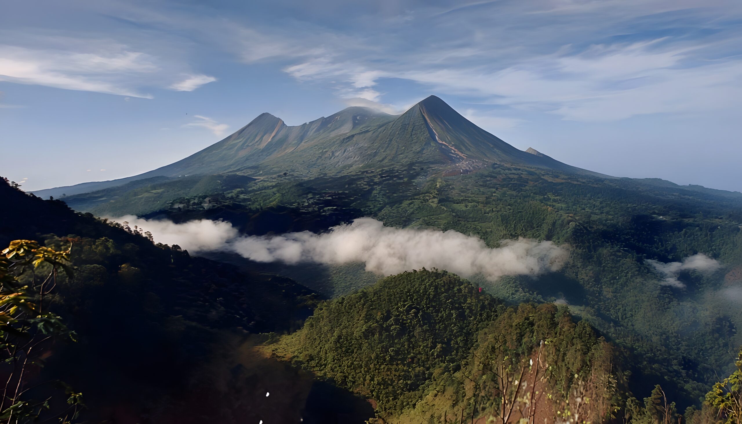
Mount Cameroon – Mongo ma Ndemi (“Mountain of Greatness”) in Duala, and Fako to the Bakweri people who live on its slopes – is the highest mountain in West Africa, and the highest in sub-Saharan western and central Africa. Some sources (Britannica among them) put it at 4,095 m; most climbing sources use 4,040 m (13,255 ft). Either way, its real distinction isn’t raw height but the way it stands: rising almost from sea level to over 4,000 m within about 30 km of the Atlantic, it is one of the most topographically prominent peaks on Earth – an “Ultra” with roughly 3,900 m of prominence. Three things make it special.
Five ecosystems on one trail
Few climbs anywhere compress so much life into so little distance. The trail from Buea passes through tropical rainforest, montane forest, savannah grassland, alpine scrub, and finally barren volcanic scree – the same span of biomes that takes weeks to cross the East African Rift, walked here in about 12 km of ascent. The lower forest still shelters forest elephants, Preuss’s monkey, and the drill, plus plant species found on no other mountain.
An active volcano you walk across
Mount Cameroon is the only currently active volcano on the Cameroon Volcanic Line and one of the most active in Africa, with roughly seven to eight confirmed eruptions in the last century (1909, 1922, 1925, 1954, 1959, 1982, 1999, and 2000). Climbers cross black scree from the recent flows, pass sulphur vents near the top, and share the flanks with more than 100 cinder cones. The 1999 eruption sent a lava flow 9.2 km down the mountain, cutting the coastal highway and stopping barely 200 m from the sea.
Non-technical, but never trivial
Unlike Mount Stanley’s glaciers or Mount Kenya’s technical Batian, Mount Cameroon is a hike from bottom to top – no ropes, no crampons, no experience required. That accessibility is real, but it isn’t the same as easy: 3,170 m of gain, rainforest humidity, cold and wind above 3,500 m, and no reliable water on the upper mountain. Treated with respect, it’s one of the most rewarding non-technical mountains anywhere – and one of the great entries on any list of the world’s best non-technical peaks to trek.
The security reality: plan around this first
The mountain is straightforward; getting to it safely is the real question in 2026.
Mount Cameroon rises directly above Buea, capital of Cameroon’s Southwest Region – one of the two English-speaking regions at the centre of the Anglophone Crisis, an armed conflict between separatist groups and government forces that escalated in 2016–17 and continues today. This is not a historical footnote; it is the defining planning factor for a Mount Cameroon trip right now.
What this means in practice. Some climbers and local operators still complete Mount Cameroon ascents during calmer windows, and the MCIEO continues to run guided climbs. But the security picture is serious and can change week to week: road closures, “ghost town” shutdowns, and clashes occur with little warning. If you are weighing a trip, three things are non-negotiable: check your own government’s current advisory (not this page – advisories move); confirm that your travel and rescue insurance actually covers Cameroon’s Southwest Region, since many policies exclude “do not travel” zones and would be void there; and take the guidance of an established Buea-based operator on timing and specific routes.
Who should climb it
Security aside, the physical bar is honest multi-day endurance – no exotic skills.
A good fit if you’re a fit hiker with multi-day trekking experience. If you’ve handled something like the Tour du Mont Blanc, the Inca Trail, or an Annapurna trek and have a solid cardio base, the mountain asks for stamina, not technique. It’s also a strong, affordable stepping stone toward Kilimanjaro: real altitude exposure at 4,040 m, the same basic hut-and-porter rhythm, and big daily gain – at a fraction of the cost. The Kilimanjaro progression plan shows where it fits.
Not a good fit if you have no multi-day hiking base or altitude exposure (build that first), if you have serious cardiovascular disease or uncontrolled hypertension (the 4,040 m altitude is real cardiac stress – see a doctor), or if you’d be attempting the June–September wet season, when the mountain’s western flank sees some of the heaviest rain in Africa. And there is no legal solo option: a licensed MCIEO guide is mandatory.
The routes
One dominant trail, one scenic circuit, and one legendary race.
| Route | Start | Distance | Days | Best for |
|---|---|---|---|---|
| Guinness Trail | Buea (~870 m) | 12.7 km one way | 2–3 | Standard route; ~90% of climbers |
| Mapanja Circuit | Buea up, Mapanja down | ~20 km circuit | 3–4 | Full ecological + cultural experience |
| Race of Hope | Buea | 38 km round trip | 1 (race) | Elite mountain runners only |
Route 1 · The Guinness Trail (Mountaineer Route)
Used by roughly 90% of climbers, the Guinness Trail – also called the Mountaineer Route or Mann Spring Trail – starts near Buea (~870 m) and climbs through a chain of huts to the summit. The standard two-day rhythm: Day 1 from Buea up through rainforest to Hut 1 (~1,850 m) and on to Hut 2 (~2,850 m), 5–8 hours; Day 2 a pre-dawn summit push past Hut 3 (~3,760 m) to the top at 4,040 m, then all the way down to Buea, 8–12 hours. Some parties add a third day to break the long descent.
Route 2 · The Mapanja Circuit
Ascends the Guinness Trail but descends a different line through the village of Mapanja on the southern flank. The circuit trades more time and cost for more varied scenery, better acclimatisation, less backtracking, and the chance to pass through traditional Bakweri villages. It ends away from Buea, so you’ll arrange transport back or continue to the Limbe coast.
Route 3 · The Race of Hope
Not a climbing route but an extreme race, traditionally held each February since 1973: the full Guinness Trail from Buea to summit and back – 38 km, 3,170 m up and 3,170 m down – in a single day. Course records sit around 4 hours 24 minutes (men) and 5 hours 22 minutes (women). It’s for experienced mountain and ultra runners only, but its half-century history is why the standard trail carries the Guinness name.
Summit day, hour by hour
From Hut 2 (2,850 m) to the top and back to Buea – the crux of the standard climb.
2026 costs
One of Africa’s most affordable major climbs – the climb itself is cheap; the flights aren’t.
| Item | 2026 cost (USD) | Notes |
|---|---|---|
| Guided climb (2–3 days, group of 2–4) | $250–450 / person | MCIEO guide, porters, hut fees, basic meals, park entry |
| Solo climber | $400–600 | Full guide/porter cost without cost-sharing |
| Mapanja Circuit (3–4 days) | $400–650 / person | Extra day and circuit logistics |
| Flights to Douala (DLA) | $800–1,800 | Air France, Brussels Airlines, Royal Air Maroc common |
| Cameroon visa | $70–140 | Required for most nationalities; obtain in advance |
| Douala–Buea transport | $20–100 | ~3 hours each way; shared taxi to private vehicle |
| Buea hotels + meals | $110–470 | Mid-range $30–80/night; food is inexpensive |
| Travel insurance | $50–150+ | Must cover the Southwest Region — many exclude it |
| Full international trip | $1,400–3,400 | From North America / Europe, all in |
| Regional African climber | $300–700 | Without international flights |
For comparison, a Kilimanjaro expedition typically runs $2,800–6,500 and Mount Stanley $2,500–5,000+. The climb itself here is a bargain; the cost and the complexity are in getting to Buea. Run your own figures through the expedition budget calculator, and make sure any policy you buy is valid via the mountaineering insurance guide.
Gear checklist
Simple compared with technical peaks — layers, footwear, water, and a hut sleep system.
Footwear & clothing
- Broken-in hiking boots or trail-running shoes with good scree traction
- Camp shoes for the huts; 3–4 pairs merino socks + liners
- Base layer (merino/synthetic), fleece mid-layer, light down/synthetic jacket
- Waterproof shell jacket + pants (rain is possible even in the dry season)
- Warm hat, sun hat, light gloves, sunglasses
Pack, sleep, hydration & health
- 45–60 L pack; sleeping bag rated to ~−5 °C + liner; small summit daypack
- 3 L water capacity (no reliable water above ~2,000 m) + purification
- Headlamp + spare batteries; trekking poles for the scree descent
- Sunscreen SPF 50+, lip balm, insect repellent, personal first-aid/blister kit
- Anti-malarials + yellow-fever certificate (required for entry); passport + visa
Rental in Buea is limited — arrive self-sufficient. For deeper dives, see the layering guide and boots guide.
When to climb
Dry season only, really — the wet season here is among the wettest on Earth.
Nov–Mar · Dry
The window. Drier trails, better visibility, most reliable summit views. Dec–Feb is the peak; the Race of Hope runs in late February.
Apr–May · Transition
Rain increasing, conditions variable. Climbable but accept the chance of a wet trip.
Jun–Sep · Wet
Not recommended. Debundscha at the base records 10,000 mm+ a year — saturated trails, flash-flood risk, no views.
Oct · Transition
Drying out, fewer crowds. Late October can be acceptable ahead of peak season.
History & the Race of Hope
From a 5th-century-BC eruption at sea to a half-century of mountain running.
~450 BC — the oldest record. The Carthaginian navigator Hannon described a flaming mountain on the West African coast in his Periplus — almost certainly Mount Cameroon, making it one of the earliest active volcanoes in the human historical record.
The Bakweri and Efasa-Moto. The Bakweri people of the eastern and southern slopes have long regarded the mountain as the home of the deity Efasa-Moto, and their name for it, “Fako,” also names the surrounding division. Eruptions were traditionally read as the deity’s moods; climbing protocols, traditional medicine, and festivals still connect community life to the peak.
1861 — first recorded ascent. The English explorer Sir Richard Burton, together with the German botanist Gustav Mann (whose name survives at Mann’s Spring, ~2,440 m), made the first documented summit in 1861, published through the Royal Geographical Society. Systematic European exploration followed during the German colonial period (Cameroon was a German protectorate from 1884 to 1916).
A century of eruptions. Confirmed 20th-century events in 1909, 1922 (a flow reached the coast), 1925, 1954, 1959, and 1982 preceded the well-documented 1999 eruption — a 9.2 km lava flow that severed the coastal highway and forced evacuations — and the 2000 summit-region eruption. A short unconfirmed event may have occurred in 2012.
1973 — the Race of Hope begins. First run in 1973 and sponsored by Guinness Cameroon (hence “Guinness Trail”), the annual Buea-to-summit-and-back race has become one of Africa’s iconic mountain-running events and the anchor of the local climbing economy.
Frequently asked questions
What is the highest mountain in West Africa?
Mount Cameroon, at 4,040 m (13,255 ft) — also the highest in sub-Saharan western and central Africa. Some sources cite 4,095 m. It’s an active stratovolcano near Buea, on the Gulf of Guinea coast. Several East African peaks rise above it by elevation (the ‘fourth in Africa’ label is inaccurate), but it ranks among the world’s most prominent mountains, an “Ultra” with ~3,900 m of prominence.
Is it safe to climb Mount Cameroon right now?
Access is seriously constrained. Buea is in the Southwest Region, and as of May 2026 the US State Department has a Level 4 “Do Not Travel” advisory there (terrorism, kidnapping, IEDs), with the UK, Canada, and Australia advising against all travel. Some climbs still happen during stable windows, but check your government’s current advisory, confirm insurance that covers the region, and decide for yourself. This is not the routine planning of a decade ago.
How much does it cost to climb in 2026?
Roughly $250–450 per person for a 2–3 day guided group climb, or $400–600 solo, including the mandatory MCIEO guide, porters, huts, meals, and park entry. A full international trip runs $1,400–3,400 — far less than Kilimanjaro or Mount Stanley.
Is Mount Cameroon technical?
No — a non-technical trek on all standard routes. No ropes, crampons, or experience needed. The challenge is endurance: ~3,170 m of gain over ~12.7 km one way, plus humidity low down and cold, wind, and altitude up high.
Do I need a guide?
Yes — a licensed MCIEO guide is mandatory; independent climbing isn’t permitted. The fee is modest ($30–60/day) and covers routefinding, weather calls, porters, cultural context, and safety oversight.
When is the best time to climb?
November–March, best December–February. Avoid June–September — the wet season here is among the heaviest-rainfall periods anywhere in Africa.
Sources & methodology
Elevation, geology, and first-ascent history compiled from Encyclopædia Britannica, the Smithsonian Global Volcanism Program, the Royal Geographical Society (Burton, 1861–62), and Suh et al. (2003) on the 1999–2000 eruptions. Route, hut, cost, and MCIEO logistics from Buea-based operators and independent trip reports (P600, Country Highpoints). Security status from the US State Department (May 2026), UK FCDO, Global Affairs Canada, and Australia’s Smartraveller, current to mid-2026.
Elevations are given metres-first with feet in parentheses. Advisory status, operator pricing, and eruption/monitoring data all change — verify with official sources (and your own government’s advisory) before booking or travelling.
West Africa’s roof — with eyes open
Mount Cameroon is a magnificent, affordable, non-technical volcano. It also sits above a region under active travel warnings. Do the honest homework first — advisory, insurance, local guidance — then decide. If the timing isn’t right, Toubkal and Kilimanjaro are waiting.
Africa’s Highest Peaks → Consider Toubkal →This peak is one of Africa’s highest and most notable mountains
Africa’s highest peaks span four regions and host some of the most diverse mountaineering objectives in the world. See the complete collection covering Africa’s Triple Crown (the only three 5,000m+ peaks), all 11 major African peaks with elevations and first ascents, regional groupings, volcanic peaks, and a 6-step climbing progression order from Toubkal through Kilimanjaro.
View All Africa’s Highest Peaks →🏔 Part of Africa’s Highest Peaks
One of Africa’s 11 major climbing peaks across 4 regions. See the full collection with Triple Crown, volcanic peaks, and costs.
View All Africa’s Peaks →Mount Kilimanjaro belongs to both the Seven Summits and Africa’s Highest Peaks
As Africa’s highest peak (5,895m) and the world’s tallest free-standing mountain, Kilimanjaro is the headline summit of two iconic mountaineering collections. The Seven Summits requires climbing the highest peak on every continent; Africa’s Highest Peaks covers all 11 major African peaks across 4 regions including the Triple Crown.
Seven Summits → Africa’s Peaks →Was this helpful?
🏔Related peaks nearby
🧭Explore & compare
Global Summit Guide is an independent mountaineering resource founded in 2026. The team combines first-hand trekking and climbing experience with in-depth research and professional health and nutrition review to help climbers choose objectives, prepare properly, and stay safe.
Health, altitude, and nutrition content is reviewed by Taylor Ludlow (Registered Nurse) and Brigg Hoopes (Nutritionist).
What We Don't Know Yet
Mountain information changes quickly. This box explains the limits of what this page can responsibly promise.
- Guide-company prices, departure dates, guide ratios, included services, and cancellation rules can change without notice.
- Total trip cost can change with flights, lodging, guide pricing, permits, gear rentals, transportation, and exchange rates.
- Visa, passport, vaccination, border, insurance, and local transportation rules may change before your trip.
Verify current conditions with official land managers, guide services, local forecasts, and current route reports before booking or climbing.
Part of this Global Summit Guide cluster
Explore the complete Mountains guide for more context, routes, planning links, and related resources.
Mountaineering, rock and ice climbing, glacier travel, and high-altitude activity are inherently dangerous and can result in serious injury or death. The information on Global Summit Guide is provided for general informational and educational purposes only and is not a substitute for professional instruction, qualified guiding, proper equipment, or your own judgment and experience.
Route conditions, weather, snowpack, permits, regulations, and hazards change constantly and may differ from what is described here. Details may be incomplete, out of date, or contain errors. Always verify current information with local authorities, certified guides, and official sources before making any decision in the mountains.
Nothing on this site is medical, legal, or financial advice. Our fitness, acclimatization, altitude, and nutrition content is general in nature; consult a qualified physician before beginning any strenuous exercise program or exposing yourself to high altitude.
You are solely responsible for your own safety and decisions. To the fullest extent permitted by law, Global Summit Guide and its team accept no liability for any loss, injury, damage, or expense arising from use of, or reliance on, this information. By using this site you acknowledge these risks and accept these terms.
Some links on this site may be affiliate links. If you buy through them we may earn a small commission at no extra cost to you; this never affects our recommendations.
Global Summit Guide recommendation path
Next Best Mountain to Research
Use these recommendations to continue the right planning path instead of stopping on one page.
Use current permit, weather, route, and operator information before booking or climbing.