Climbing Mexico’s Volcanoes: High-Altitude Peaks of the Trans-Mexican Volcanic Belt
Mexico’s Trans-Mexican Volcanic Belt holds five of North America’s highest peaks and offers the continent’s best-value altitude acclimatization progression: a 10-14 day trip from sea level to 5,636m for under $3,000. Pico de Orizaba, Iztaccihuatl, and La Malinche form the classic three-peak itinerary used by Aconcagua, Denali, and Everest aspirants. Popocatépetl, Mexico’s second-highest peak, has been closed to climbing since 1994. This guide covers all six major Mexico volcanoes, the classic acclimatization sequence, and how Mexico fits into the global altitude training pathway.
3rd highest in N.A.
volcanic peaks
itinerary
cost (guided)
Mexico’s volcanoes occupy a specific and valuable role in global mountaineering: they are where North American and European climbers go to get serious altitude exposure without an expedition budget. Pico de Orizaba (Citlaltépetl) at 5,636m is the third-highest peak in all of North America — behind only Alaska’s Denali and Canada’s Mount Logan — and climbing it is cheaper than most multi-day Rainier programs. The classic Mexico volcanoes itinerary combines La Malinche, Iztaccihuatl, and Pico de Orizaba into a 10-14 day altitude progression that delivers more acclimatization in two weeks than most North American training peaks provide in a season. This guide covers the six major Mexican volcanoes, the classic itinerary, and why Mexico sits at a specific waypoint in the altitude training pathway toward Aconcagua, Denali, and eventually the Himalaya.
Understanding the Trans-Mexican Volcanic Belt
Mexico’s major climbing peaks are volcanoes — specifically, stratovolcanoes of the Trans-Mexican Volcanic Belt (TMVB), a 900-kilometer east-west volcanic arc stretching across central Mexico from the Pacific coast near Puerto Vallarta to the Gulf of Mexico near Veracruz. The belt is part of the Pacific Ring of Fire, formed by the subduction of the Cocos Plate beneath the North American Plate. The TMVB hosts dozens of volcanoes; six of them rise above 4,000 meters and concern climbers, with the top three (Orizaba, Popocatépetl, Iztaccihuatl) all exceeding 5,000m.
Geographically, the climbing peaks cluster in two main areas. The central cluster near Mexico City holds Iztaccihuatl and Popocatépetl (paired volcanoes about 60km east of the capital), plus Nevado de Toluca to the west and Ajusco at the city’s southern edge. The eastern cluster in Puebla and Veracruz states holds Pico de Orizaba and La Malinche, which together anchor the classic Mexico volcanoes itinerary. Both clusters are accessible from Mexico City International Airport (MEX), typically the entry point for international climbers.
What makes these peaks distinctive is their combination of high altitude, non-technical standard routes, and affordable access. Unlike the Andes (which require international travel and complex permits for peaks over 5,000m) or the Himalaya (which require expedition logistics), Mexico’s high peaks can be climbed on weekend trips from the US. A climber in Denver can be on Pico de Orizaba’s summit within 48 hours of leaving home, which positions Mexico uniquely as the continent’s most accessible altitude training destination.
Mexico as the Acclimatization Stepping Stone
The fundamental reason most climbers visit Mexico’s volcanoes is altitude training. The peaks’ elevations — 4,461m on La Malinche, 5,230m on Iztaccihuatl, and 5,636m on Pico de Orizaba — cover the full altitude progression needed before attempting Aconcagua (6,961m), Denali (6,190m), Kilimanjaro (5,895m), or any Himalayan trekking peak. Mexico delivers this progression in 10-14 days at a fraction of the cost and logistical complexity of visiting any other serious altitude destination.
Consider the alternatives. Climbing Aconcagua as “altitude training” costs $6,000-$10,000 and requires 18-21 days. Reaching Everest Base Camp for altitude exposure costs $2,500-$5,000 and takes 14-16 days of trekking. Climbing Kilimanjaro runs $2,500-$5,000 and takes 8-10 days. Mexico’s three-peak progression costs $1,500-$3,000 and fits in 10-14 days — and unlike Kilimanjaro (which tops out at 5,895m with a single summit), Mexico provides three separate altitude summits at 4,461m, 5,230m, and 5,636m, giving climbers multiple chances to test their altitude tolerance under different conditions.
Altitude Progression: 2,240m → 5,636m
Mexico City sits at 2,240m — already at meaningful altitude for sea-level residents, which means climbers begin acclimatizing from the moment they land. Each subsequent peak builds on the previous: La Malinche (4,461m) clears the 4,000m threshold; Iztaccihuatl (5,230m) enters the extreme altitude zone; Pico de Orizaba (5,636m) provides summit exposure comparable to Everest Base Camp.
Altitude Tolerance Testing
The primary diagnostic value of Mexico is identifying whether a climber’s body handles altitude well before they spend $40,000+ on Everest or $6,000+ on Aconcagua. Climbers who experience severe AMS symptoms on Iztaccihuatl’s 5,230m summit can reasonably predict similar difficulty at higher altitudes. Those who feel strong on Pico de Orizaba’s 5,636m are good candidates for Aconcagua.
Glacier & Mountaineering Skills
Pico de Orizaba’s Jamapa Glacier route develops essential skills for higher objectives: rope team travel, crampon technique on exposed ice, self-arrest on moderate slopes, and cold-weather camping at 4,260m at Piedra Grande hut. These are directly transferable to Denali, Aconcagua, and the Cascade volcanoes. Iztaccihuatl adds scrambling and mixed terrain experience.
Cost Efficiency
Mexico’s combination of high altitude, non-technical routes, affordable operators, and proximity to major airports makes it the single most cost-effective altitude training destination in the Americas. A guided 10-day Mexico volcanoes trip delivers more acclimatization per dollar than any comparable program. This matters for climbers budgeting multi-year progressions toward the Seven Summits or Himalayan objectives.
The climbers you meet on Iztaccihuatl and Pico de Orizaba fall into three main groups: (1) Aconcagua/Denali aspirants doing pre-expedition altitude training, typically 6-18 months before their bigger trip; (2) climbers building toward the Seven Summits using Mexico as the second or third peak after Kilimanjaro or Elbrus; (3) experienced mountaineers who return to Mexico annually to maintain altitude fitness and run clients. Few climbers visit Mexico for Mexico’s sake — the peaks are almost universally part of a larger progression toward higher objectives elsewhere.
Mexico’s 6 Major Climbing Volcanoes: Comparison Table
The table below lists the six Mexico volcanoes covered in detail in this guide, ranked by elevation. The “role” column indicates each peak’s position in the typical climbing progression.
| # | Peak | Elevation | State | Role in Progression | Difficulty | Best Season |
|---|---|---|---|---|---|---|
| 1 | Pico de Orizaba (Citlaltépetl) | 5,636 m / 18,491 ft | Puebla/Veracruz | Main objective | Moderate (glacier) | Nov–Mar |
| 2 | Popocatépetl | 5,426 m / 17,802 ft | Puebla/Morelos | Closed (1994+) | N/A — do not attempt | Closed |
| 3 | Iztaccihuatl | 5,230 m / 17,160 ft | México/Puebla | Main objective | Moderate mountaineering | Nov–Mar |
| 4 | Nevado de Toluca (Xinantécatl) | 4,680 m / 15,354 ft | México | Acclimatization | Easy-Moderate | Nov–Mar |
| 5 | La Malinche (Matlalcueye) | 4,461 m / 14,636 ft | Tlaxcala/Puebla | Acclimatization | Moderate hike | Nov–Mar |
| 6 | Ajusco (Xitle/Pico del Águila) | 3,930 m / 12,894 ft | Mexico City | Day trip | Easy hike | Nov–May |
Mexico’s 6 Major Volcanoes: Detailed Breakdown
The sections below cover the six major Mexico volcanoes in detail, ordered by elevation. Each entry describes the volcano’s character, standard route, cultural significance, and practical climbing considerations.
Pico de Orizaba (Citlaltépetl)
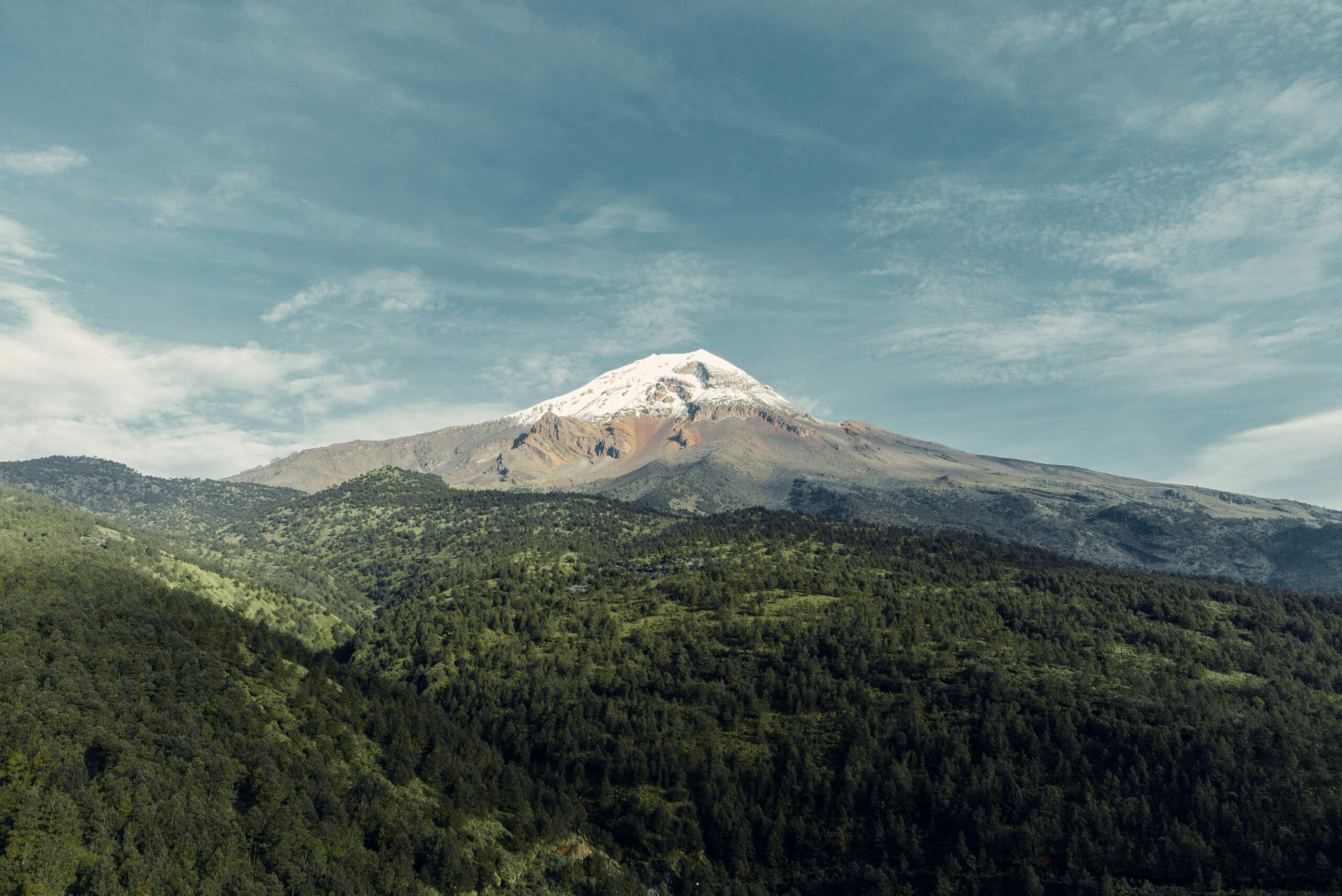
Pico de Orizaba is Mexico’s highest peak, the third-highest mountain in North America (after Denali at 6,190m and Mount Logan at 5,959m), and the culminating objective of virtually every Mexico volcanoes itinerary. Known locally as Citlaltépetl — “star mountain” in Nahuatl, the pre-Columbian Aztec language — the peak is a dormant stratovolcano whose last confirmed eruption occurred in 1846. The volcano rises in near-perfect conical symmetry from the surrounding Puebla-Veracruz highlands, visible on clear days from the Gulf of Mexico coast 100 kilometers to the east. First climbed on May 1, 1848 by American soldiers F. Maynard and William F. Raynolds during the aftermath of the Mexican-American War, Pico de Orizaba has been a significant mountaineering objective since the 19th century.
The standard Jamapa Glacier route from the Piedra Grande hut (4,260m) is the most climbed line and the route most Mexico volcanoes operators use. The climb involves: an alpine start around midnight, ascent through rocky moraine to the glacier edge at around 4,900m, crampons-on across the Labyrinth (a maze of crevasses that has grown significantly more complex as the glacier has retreated), sustained snow and ice climbing up the glacier to the crater rim at 5,500m, and a final ridge traverse to the summit. Total climb time from hut to summit runs 8-12 hours; round-trip 14-18 hours. The crux is altitude and endurance, not technical difficulty.
What climbers should understand is that the Jamapa Glacier has changed dramatically since 2000. The glacier has retreated more than 200 meters vertically and exposed significant crevassed terrain that requires genuine route-finding. Current climbing parties often need to navigate around large crevasses on the Labyrinth that were minor features 20 years ago. This has added legitimate technical difficulty to what was once a simple snow walk. Recent research documents intense freeze-thaw cycles in the glacier retreat zone creating unstable rock and ice conditions above 4,000m — climbers should expect more complex conditions than older guidebooks describe. A guide with current-season knowledge is strongly recommended.
Full Pico de Orizaba climb guide →Popocatépetl
Popocatépetl is Mexico’s second-highest peak and the most active major volcano in North America. The name derives from Nahuatl — popōca (it smokes) and tepētl (mountain): “the smoking mountain” — and proves accurate on almost any day. Popocatépetl, or “Popo” as it’s universally called in Mexico, entered an active eruptive phase in December 1994 after roughly 70 years of dormancy. That eruption has continued uninterrupted for more than three decades, with thousands of discrete eruptions, frequent ash plumes reaching 5-8 kilometers altitude, periodic dome-building phases, and continuous monitoring by CENAPRED (Mexico’s National Center for Disaster Prevention).
Climbing Popocatépetl is prohibited and has been since the 1994 reactivation. CENAPRED maintains a 12-kilometer exclusion zone around the summit. The volcano’s alert system — a traffic-light semaphore — has cycled through Yellow Phase 2 and Phase 3 for most of the past three decades, with occasional Yellow Phase 1 periods when activity quiets briefly. Unauthorized climbing is illegal under Mexican law and potentially fatal: multiple climbers have died in ash plume events, pyroclastic flows, and lahars. The last legal summit attempts predate most current climbers’ careers. Despite being visible from Mexico City and a 2-hour drive from the capital, Popo is firmly off-limits.
What climbers can do is admire Popo from Iztaccihuatl and Paso de Cortés — the two are paired volcanoes separated by the Paso de Cortés pass, and the view of Popo’s ash plume from Iztaccihuatl’s ridge is one of the most iconic sights in Mexican mountaineering. In Aztec legend, Popocatépetl was a warrior and Iztaccihuatl was his sleeping love — the mountains’ silhouettes are read as the warrior kneeling beside the sleeping woman. This story is culturally fundamental in central Mexico and adds meaning to climbing Iztaccihuatl specifically. For current volcanic status, climbers should check CENAPRED’s website or the Servicio Sismológico Nacional before visiting.
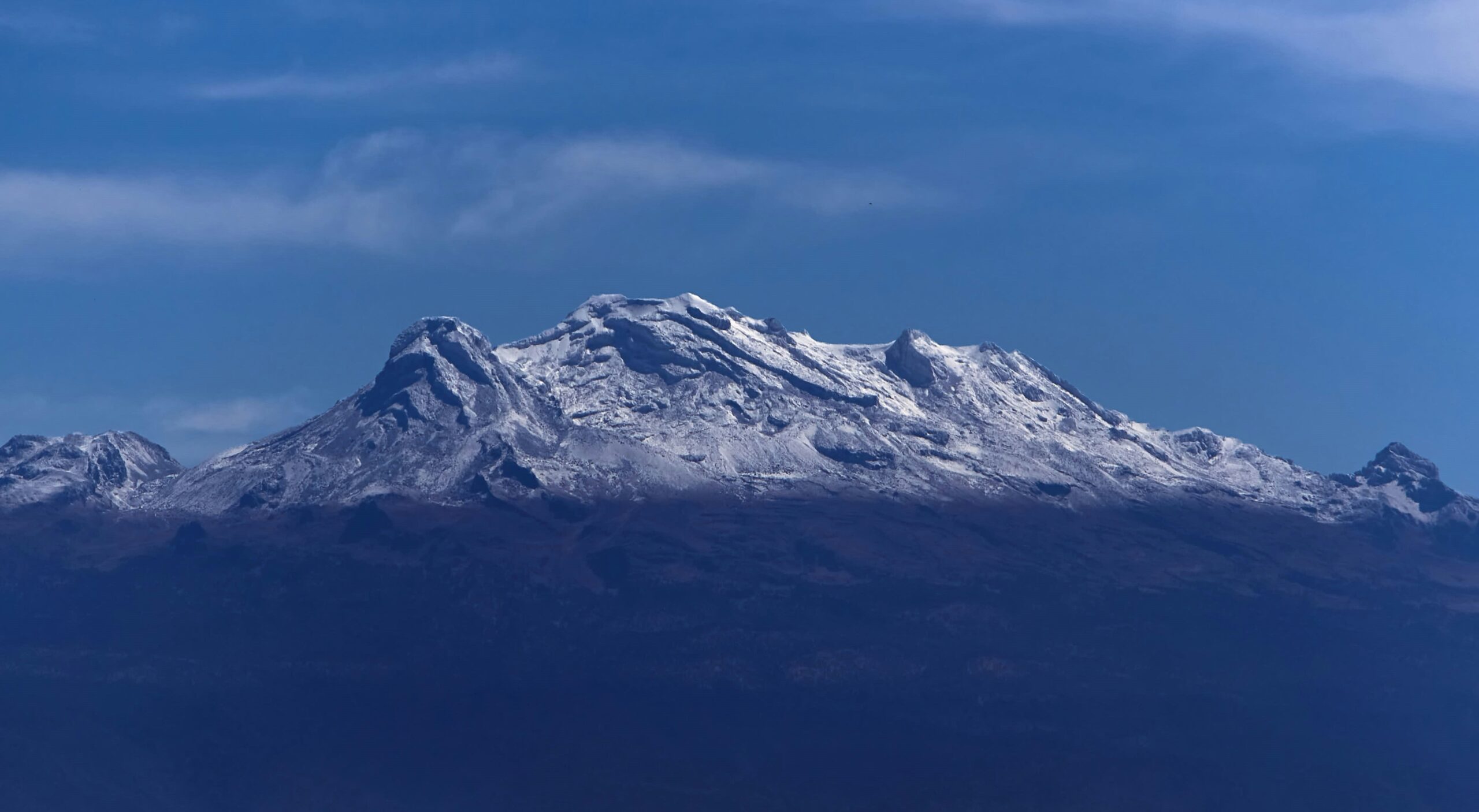
Iztaccihuatl (Ixta)
Iztaccihuatl is Mexico’s third-highest peak and — with Popocatépetl closed — the most popular serious mountaineering objective in the country after Pico de Orizaba. The name means “white woman” in Nahuatl, derived from iztāc (white) and cihuātl (woman), reflecting the mountain’s profile: a ridge of four summit peaks (Los Pies, Las Rodillas, El Pecho, La Cabeza — the feet, knees, chest, and head) that together form the silhouette of a reclining female figure. Known colloquially as “Ixta,” the peak is shared by the states of México and Puebla within Izta-Popo Zoquiapan National Park — the same park that contains prohibited Popocatépetl.
The standard Arista del Sol (Ridge of the Sun) route — also called the “Knees route” — starts from La Joya trailhead at 3,900m, accessed from the Paso de Cortés park entrance. Climbers ascend past the Ayoloco Refuge (4,750m) or camp there, then continue via the exposed summit ridge over the false summits (Los Pies and Las Rodillas) before reaching El Pecho, the true summit at 5,230m. The route involves mixed scrambling, some scree, and moderate snow climbing depending on season. Total round-trip from La Joya runs 10-14 hours for acclimatized parties. Most climbers use a 2-day format with one night at Ayoloco.
What makes Iztaccihuatl the ideal second-peak in the Mexico progression is that it builds real mountaineering skills — crampon use, exposure on steep terrain, altitude over 5,000m — without the technical glacier demands of Pico de Orizaba. Climbers with La Malinche experience and solid fitness can summit Ixta and use it as a proving ground for Orizaba the following week. The views across Paso de Cortés to active Popocatépetl — often erupting ash plumes visible from the summit ridge — add a dimension of volcanic spectacle no other Mexico climb offers.
Full Iztaccihuatl climb guide →Nevado de Toluca (Xinantécatl)
Nevado de Toluca, known by its Nahuatl name Xinantécatl (“naked man” or “naked gentleman”), is Mexico’s fourth-highest peak and its most visually distinctive — the summit contains a wide, partly collapsed crater holding two permanent lakes: Lago del Sol (Lake of the Sun) and Lago de la Luna (Lake of the Moon). The volcano sits about 80 kilometers west of Mexico City in the State of México, making it the most accessible 4,000m+ peak for Mexico City-based climbers. Nevado de Toluca is dormant — its last known eruption occurred approximately 3,300 years ago — and the crater lakes have significant archaeological importance as Aztec and earlier ritual offering sites.
The standard climb is non-technical and operates as either a day hike or overnight trip. A dirt road climbs from the town of Raíces to within the crater itself at approximately 4,200m, dramatically shortening the approach. From there, parties typically hike around the crater rim to the summit of Pico del Fraile at 4,680m — a 4-6 hour round trip involving rocky scrambling but no real technical climbing. Some climbers combine the hike with a descent into the crater to visit the lakes, which requires an additional hour or two. For climbers staying in Mexico City, Nevado de Toluca works as a weekend day trip that delivers authentic high-altitude exposure.
What makes Nevado de Toluca useful in the Mexico volcanoes progression is its position as a higher-altitude alternative to La Malinche for the first acclimatization peak. Where La Malinche tops out at 4,461m, Nevado de Toluca’s 4,680m summit pushes altitude testing slightly higher. The road-accessible upper slopes also make it possible to sleep at 4,200m — a powerful acclimatization step that’s useful before attempting Iztaccihuatl. Some operators substitute Nevado de Toluca for La Malinche in their itineraries when weather or scheduling preferences align better with the western cluster.
La Malinche (Matlalcueye)
La Malinche is Mexico’s sixth-highest peak and the standard first peak in virtually every Mexico volcanoes itinerary. The mountain is an extinct stratovolcano rising from the plains between the states of Tlaxcala and Puebla, about 130 kilometers east of Mexico City and directly on the route to Pico de Orizaba. The Nahuatl name is Matlalcueye — “lady with a blue-green skirt” — referring to the blue pine forest that wraps the mountain’s flanks. The Spanish name “La Malinche” derives from Malintzin (also called Doña Marina), the Nahua woman who served as translator and companion to Hernán Cortés during the Spanish conquest; the mountain was renamed in her honor or, depending on historical interpretation, her shame.
The standard La Malinche climb from the IMSS vacation center at 3,100m is a moderately demanding day hike: 14 kilometers round trip, approximately 1,360 meters of elevation gain, and 6-9 hours total. The route climbs through pine forest, then ponderosa woodland, then alpine tundra, and finally loose volcanic scree to the summit. No technical climbing is required and no mountaineering gear is needed beyond good boots, layers, and trekking poles. The summit day exposes climbers to the 4,000m+ zone for the first time in a typical progression, setting up bodies for the harder peaks that follow.
What makes La Malinche functionally essential for any Mexico volcanoes trip is its combination of easy access, meaningful altitude, and low cost. IMSS-Tlaxcala charges $6-$10 for park entry, accommodation at the base is $30-$60/night in simple cabins, and a guide costs $50-$100 per day. A climber can fly into Mexico City, transfer to Tlaxcala the same day, summit La Malinche the next morning, and be ready for Iztaccihuatl a few days later — a remarkably efficient acclimatization sequence. For climbers on tight schedules, La Malinche can be compressed into a single day from Mexico City with early transport, though this sacrifices the rest time that makes the acclimatization work.
Ajusco (Pico del Águila)
Ajusco is the highest peak within Mexico City’s municipal boundaries — a dormant shield volcano at the city’s southern edge whose silhouette defines the capital’s southern skyline. The primary summit is Pico del Águila (“Eagle’s Peak”) at 3,930m, with a secondary summit at Cruz del Marqués (3,900m). The mountain name derives from Nahuatl — a-xōcho (water) and co (place): “place of water” — reflecting its role as a key watershed for the Valley of Mexico. Ajusco is part of the Ajusco-Chichinauhtzin Biological Corridor, a chain of protected areas south of Mexico City that serves as the capital’s primary green space.
The standard hike to Pico del Águila from the Ajusco road is a 3-4 hour round trip with moderate fitness demands and no technical climbing. The route climbs through alpine meadow and rock scrambling on the upper sections — the final summit block requires some hands-on scrambling but no gear. Parking is available at multiple access points along the Ajusco road (Carretera Picacho-Ajusco); the most popular starting point is the INSEN parking area. The summit offers exceptional views of Mexico City’s sprawl on clear days and of the larger volcanoes — Popocatépetl’s ash plume, Iztaccihuatl’s profile, and sometimes Pico de Orizaba to the east.
For climbers acclimatizing on arrival in Mexico City, Ajusco is an ideal first-day hike. Flying in to Mexico City International Airport (MEX) at 2,240m, spending a day at the hotel, then climbing Ajusco the second day provides a gentle altitude progression that’s measurably better than simply resting at 2,240m for two days. The mountain is also popular with Mexico City climbers for weekly training hikes. Note that Ajusco has historically had some security concerns related to car break-ins at trailheads; most guides recommend parking at the INSEN lot rather than more isolated pullouts, and the mountain is much safer during weekends when other hikers are present.
The Classic Mexico Volcanoes Itinerary
Most guided Mexico volcanoes trips follow a well-established 10-14 day progression that combines La Malinche, Iztaccihuatl, and Pico de Orizaba with appropriate rest and transit days. This itinerary has been refined over decades of commercial guiding and delivers the altitude progression climbers need for Aconcagua, Denali, or Everest preparation. Variations exist — some operators substitute Nevado de Toluca for La Malinche, some add Ajusco as a day-1 acclimatization hike, some compress or expand the schedule — but the core structure is remarkably consistent across the industry.
Arrive Mexico City 2,240m
Arrive at Mexico City International Airport (MEX). Transfer to hotel in central Mexico City. Rest day — Mexico City at 2,240m is already meaningful altitude for sea-level residents. Hydrate, eat light, go to bed early. No climbing today.
Ajusco day hike 3,930m
Optional: drive to Ajusco south of Mexico City for a 4-hour day hike to Pico del Águila. Gentle altitude exposure to 3,930m. Return to Mexico City in afternoon. Climbers feeling strong after Day 1 often do this; those still adjusting to arrival rest again. Some itineraries skip Ajusco entirely.
Transfer to Tlaxcala 2,250m
Drive from Mexico City to Apizaco or Huamantla, Tlaxcala (~2 hours). Check into hotel. Gear check and briefing. Early dinner. This is a rest day that doubles as positioning for La Malinche. Accommodation in Tlaxcala is simpler and cheaper than Mexico City but adequate.
La Malinche summit 4,461m
Early start from the IMSS trailhead at 3,100m. 6-9 hour round trip to summit and return. First exposure to the 4,000m+ zone. Return to Tlaxcala base in afternoon. Immediate feedback on how your body handles altitude — this is the first critical data point.
Rest & transit to Paso de Cortés 3,700m
Rest day. Drive from Tlaxcala to Paso de Cortés (the pass between Iztaccihuatl and Popocatépetl) at 3,700m. The drive itself adds altitude exposure. Check into Altzomoni or similar high lodge. Afternoon acclimatization walk. Early bed.
La Joya to Ayoloco Refuge 4,750m
Drive from Paso de Cortés to La Joya trailhead at 3,900m. Climb to Ayoloco Refuge at 4,750m (3-5 hours). Afternoon at high camp acclimatizing. Early dinner, gear check for summit day. Cold night at nearly 4,800m — this is the altitude test before the summit push.
Iztaccihuatl summit & descent 5,230m
Alpine start around 3-4 AM. Summit push via the Arista del Sol route over Los Pies and Las Rodillas to El Pecho summit at 5,230m. Descend to Ayoloco, continue down to La Joya. Transfer back to lower accommodation. This is the critical altitude test — how you feel at 5,230m predicts Pico de Orizaba.
Rest day & transfer to Tlachichuca 2,640m
Essential rest day at lower elevation. Drive from Paso de Cortés area to Tlachichuca, Puebla (base for Pico de Orizaba). Long drive (4-5 hours) but mostly downhill to lower altitude for recovery. Check into Tlachichuca lodging. Hot meal, early bed.
Piedra Grande Hut 4,260m
4WD transfer from Tlachichuca up the rough road to Piedra Grande hut at 4,260m (2-3 hours by 4WD). Settle into the basic concrete hut. Short acclimatization hike to the 4,500m shoulder. Early dinner and gear prep. Try to sleep before the midnight start.
Pico de Orizaba summit 5,636m
Alpine start at midnight or 1 AM. Ascend rocky moraine to the Jamapa Glacier edge at ~4,900m. Crampons on for the Labyrinth crevasse zone, then sustained snow and ice climbing up the glacier to the crater rim. Summit between dawn and mid-morning. Long descent to Piedra Grande then down to Tlachichuca. The culminating day of the trip.
Weather contingency & departure
Transfer from Tlachichuca to Mexico City (5 hours) or Veracruz (2.5 hours) for flights home. Most itineraries include 1-2 buffer days for weather turnbacks on Iztaccihuatl or Pico de Orizaba — these are used when storms or conditions prevent summit attempts. Good operators build these in automatically.
The specific order — La Malinche first, Iztaccihuatl second, Pico de Orizaba last — is not arbitrary. Each peak provides diagnostic information: La Malinche tests general altitude tolerance at 4,461m; Iztaccihuatl extends that to 5,230m with real mountaineering; Pico de Orizaba uses the accumulated acclimatization for a 5,636m technical summit. Skipping ahead — attempting Pico de Orizaba without prior acclimatization — dramatically lowers success rates (from 60-75% down to 20-30%) and significantly raises altitude illness risk. This is why guides insist on the progression and why building it yourself requires the rest days.
The Cultural Context: Popocatépetl and Iztaccihuatl in Aztec Legend
Mexico’s volcanoes are not just geographic features. They carry more than 700 years of cultural and spiritual significance in Mesoamerican history, and understanding this context changes how visiting climbers experience the mountains. No story is more central than the legend of Popocatépetl and Iztaccihuatl — a pre-Columbian narrative that explains why these paired volcanoes carry the names they do, and why their silhouettes appear throughout Mexican art, literature, and popular culture.
The legend tells of an Aztec warrior named Popocatépetl who loved the princess Iztaccihuatl. Before the two could marry, Popocatépetl was sent into battle by her father, the emperor. A jealous rival spread word that Popocatépetl had died in combat. Iztaccihuatl, hearing the false news, died of grief. When Popocatépetl returned victorious and discovered what had happened, he carried her body to the mountains outside Tenochtitlan and laid her on a high peak, where she became the sleeping woman — her profile still visible in the four summits of Iztaccihuatl (the feet, knees, chest, and head). Popocatépetl knelt beside her with a torch to keep her warm, and the gods turned him into the neighboring volcano — eternally smoking from the torch he still carries. The story is recorded in multiple pre-Columbian sources and remains one of the most recognized legends in Mexican cultural heritage.
For climbers, this context matters because you are climbing in a living cultural landscape, not just a geographic one. Iztaccihuatl’s summit ridge really does trace a reclining female figure — the four summits (Los Pies, Las Rodillas, El Pecho, La Cabeza) are named for the body parts they represent. Climbing the peak is, in a real sense, climbing along the body of the sleeping princess. Popocatépetl’s continuous smoking — the mountain has erupted continuously since December 1994 — is read by many Mexicans as the warrior still keeping his vigil. When CENAPRED alerts update the Popo alert system, the stories circulate alongside the scientific bulletins.
Most of Mexico’s major volcanoes have both Spanish colonial names and Nahuatl (Aztec) names. The Nahuatl names are older and often more descriptive: Citlaltépetl (Star Mountain) for Pico de Orizaba, Popōca-tepētl (Smoking Mountain) for Popocatépetl, Iztāc-Cihuātl (White Woman) for Iztaccihuatl, Matlalcueye (Lady with Blue-Green Skirt) for La Malinche, Xinantécatl (Naked Gentleman) for Nevado de Toluca. Using both names in conversation — or learning the Nahuatl meanings — marks you as a climber who respects the cultural depth of where you’re climbing.
When to Climb Mexico’s Volcanoes
Mexico’s climbing season is well-defined and dictated by the country’s wet/dry seasonal pattern rather than temperature. The peaks themselves are cold year-round — high camps on Pico de Orizaba see sub-freezing temperatures most nights — but the critical variable is precipitation.
Dry Season (November–March): The Climbing Window
The dry season runs from November through March and delivers virtually all guided Mexico volcanoes trips. Skies are clear most days, weather patterns are stable, and storm systems are rare. January and February are peak season with the most consistent conditions but the coldest nights (-15°C / 5°F at high camps is common). November and March offer slightly warmer conditions with marginally more weather variability — still excellent choices for climbers who don’t tolerate extreme cold well. December has the shortest daylight hours.
Wet Season (May–October): Not Recommended
The wet season brings afternoon thunderstorms, persistent cloud cover, and unstable weather on the volcanic peaks. Climbing is possible in principle but not recommended: views are limited, lightning hazard is significant on exposed ridges, and trails become muddy and dangerous. Most commercial operators do not run programs between May and October. Local climbers sometimes attempt early-morning summits during wet season lulls, but this requires flexibility that most international travelers don’t have.
Shoulder Season (April): Transitional
April is transitional — often the last month when stable conditions prevail before the afternoon storms return. Some experienced operators run climbs through mid-April. Weather reliability drops as the month progresses.
Timing Considerations for Aconcagua Preparation
For climbers using Mexico as preparation for Aconcagua (which runs November-March in the Southern Hemisphere), the timing alignment is nearly perfect. A Mexico trip in December delivers altitude training that’s still fresh for an Aconcagua attempt in January-February. Denali aspirants typically prefer Mexico trips in January-February for May-June Denali expeditions.
Frequently Asked Questions About Climbing Mexico’s Volcanoes
What are Mexico’s highest volcanoes?
Mexico’s three highest peaks are all volcanoes in the Trans-Mexican Volcanic Belt: Pico de Orizaba (Citlaltépetl) at 5,636m, Popocatépetl at 5,426m, and Iztaccihuatl at 5,230m. Pico de Orizaba is the highest peak in Mexico and the third-highest in North America after Denali (6,190m) and Mount Logan (5,959m). Popocatépetl has been closed to climbing since 1994 due to ongoing eruptive activity. Iztaccihuatl is the most popular serious climbing objective in Mexico, followed by Pico de Orizaba as the culmination of a typical acclimatization trip.
Can you still climb Popocatépetl?
No — Popocatépetl has been closed to climbing since December 1994, when the volcano entered an active eruptive phase that continues today. CENAPRED (Mexico’s National Center for Disaster Prevention) maintains a 12-kilometer exclusion zone around the summit, and unauthorized climbs are illegal and potentially fatal. The volcano has erupted thousands of times since 1994, with ash plumes regularly reaching 5-8 kilometers altitude. The volcanic alert system has been at Yellow Phase 2 or Phase 3 for most of the past three decades. Climbers visiting the region admire Popocatépetl from Iztaccihuatl or Paso de Cortés but do not ascend it.
Is Pico de Orizaba hard to climb?
Pico de Orizaba is physically demanding but not technically difficult by mountaineering standards. The standard Jamapa Glacier route requires basic glacier travel skills — crampons, ice axe, and self-arrest technique — but no advanced climbing knowledge. The main challenge is altitude: Pico de Orizaba’s 5,636m summit places climbers in the “extreme altitude” zone where summit day typically involves 12-16 hours of effort, 1,100m of elevation gain from high camp, and exposure to winds and cold. Success rates average 60-75% for climbers who have properly acclimatized via La Malinche and Iztaccihuatl first. The glacier has retreated significantly since 2000, adding technical difficulty on some route variations.
Can beginners climb Iztaccihuatl?
Iztaccihuatl is not a beginner mountain despite having no advanced technical requirements. At 5,230m, the peak puts climbers in serious altitude territory, and the standard Arista del Sol route involves mixed scrambling, moderate snow climbing, and long summit days (10-14 hours round trip from La Joya base). Basic mountaineering skills — crampon use, ice axe technique, self-arrest — are required. Iztaccihuatl serves as an excellent second peak in the Mexico volcanoes progression after La Malinche, and as preparation before attempting Pico de Orizaba. Complete beginners with no mountaineering experience should not attempt Iztaccihuatl without prior training on easier peaks.
What is the best Mexico volcanoes acclimatization itinerary?
The classic Mexico volcanoes acclimatization progression runs 10-14 days: arrive in Mexico City (2,240m), spend 1-2 days sightseeing or at sea-level base, climb La Malinche (4,461m) as a day hike from Puebla, rest and descend to lower altitude, climb Iztaccihuatl (5,230m) with 1 night at 4,750m, rest at 2,000-3,000m, then climb Pico de Orizaba (5,636m) as the final objective. This sequence builds altitude tolerance from 2,240m to 5,636m with appropriate rest days between peaks. The itinerary is used by Aconcagua, Denali, and Everest aspirants for pre-expedition altitude training and costs $1,500-$3,000 total.
Is Mexico good training for Aconcagua?
Yes — Mexico is one of the best training destinations for Aconcagua and other high-altitude objectives. The Mexico volcanoes offer sustained altitude exposure above 4,000m over a 10-14 day period at a fraction of the cost of Aconcagua itself. Pico de Orizaba’s 5,636m summit is within 1,300 meters of Aconcagua’s 6,961m, providing realistic altitude testing without the expedition logistics. The Mexico climate is also more forgiving than Patagonian conditions — dry cold rather than wet cold, stable weather windows November through March. Most Aconcagua operators recommend or welcome climbers who have completed the Mexico volcanoes trip as preparation.
When is the best time to climb Mexico volcanoes?
The dry season runs from November through March, with December-February offering the most stable weather and best climbing conditions. January and February are peak season — cold nights (sub-freezing at high camps) but generally clear days with predictable weather windows. November and March are shoulder months with slightly warmer conditions but more variable weather. April to October is the rainy season; climbing is possible but rain, storms, and poor visibility make the experience difficult and dangerous. Most operators schedule their primary Mexico volcanoes programs for December through February. The season overlaps conveniently with Aconcagua prep planning.
Do you need a guide to climb Pico de Orizaba?
No — Pico de Orizaba is not technically required to be climbed with a guide, unlike some international peaks. However, guided climbs are strongly recommended and chosen by most international climbers. A guide provides logistical support (transportation between peaks, high camp setup, cooking), local knowledge of conditions, safety backup for altitude issues, and eliminates the complexity of navigating Mexican park permits and communities independently. Typical guided Mexico volcanoes programs run $1,500-$3,000 for 8-12 day multi-peak itineraries. Independent climbers visit the peaks for far less ($300-$600 in park fees and transport) but take on significantly more logistical burden.
How much does it cost to climb Mexico volcanoes?
A guided Mexico volcanoes trip typically costs $1,500-$3,000 per person for 8-12 day programs covering La Malinche, Iztaccihuatl, and Pico de Orizaba. Budget operators offer smaller-group trips from $1,200-$1,800. Premium operators charge $2,500-$4,000 for smaller groups and higher service levels. These costs typically include guide fees, transportation between peaks, high camp accommodation, food, and group equipment. Flights to Mexico City (MEX) or Veracruz (VER) add $300-$800 from North America. Climbers providing their own gear save approximately $200-$400 over renting. Independent climbing is significantly cheaper at $400-$800 total for the same peaks.
Where is Pico de Orizaba located?
Pico de Orizaba (Citlaltépetl) straddles the border between the states of Puebla and Veracruz in central Mexico, about 200 kilometers east of Mexico City and 100 kilometers west of the Gulf of Mexico. The standard access route starts from Tlachichuca, Puebla, a small town at 2,640m that serves as the base for climbs — most climbers reach Tlachichuca via private 4WD transport from Mexico City (4-5 hours) or Puebla city (1.5 hours). From Tlachichuca, a rough 4WD road climbs to the Piedra Grande hut at 4,260m, the standard high camp for the ascent.
Plan Your Mexico Volcanoes Trip
For detailed planning on each peak and broader acclimatization and training resources, see the guides below.
Book Your Mexico Volcanoes Progression
For most climbers, the Mexico volcanoes progression is the single most valuable training trip in the years before attempting Aconcagua, Denali, or Everest. The 10-14 day La Malinche → Iztaccihuatl → Pico de Orizaba itinerary delivers altitude testing and glacier skills at a fraction of the cost and logistics of other altitude destinations. Start with the individual peak guides for route details.
Iztaccihuatl
Pico de Orizaba