
Last updated May 21, 2026
Mount Rainier Climb Guide: The Cascade Volcanoes Anchor, the Disappointment Cleaver Route & the 1870 Stevens-Van Trump First Ascent (2026)
On 17 August 1870, Hazard Stevens and Philemon Beecher Van Trump survived a night in a steam cave on the summit crater of a 14,411-foot volcano that the Puyallup people had called Tahoma for centuries. Theirs is the first verified ascent — an 1855 claim by US Army Lieutenant August Kautz reached very high but is widely considered to have stopped short of the true summit. Today Mount Rainier is the most heavily glaciated peak in the contiguous US, the centerpiece of the 5th national park ever established (1899), and the standard “first major glacier climb” for thousands of American mountaineers each year. The June 1981 Disappointment Cleaver serac collapse killed 11 — still the worst single mountaineering accident in US history. Here’s the verified 2026 planning data.
In This Guide — Mount Rainier Detailed Sub-Pages
Mount Rainier National Park. The mountain is the centerpiece of Mount Rainier National Park — established 2 March 1899 as the 5th national park in the United States, after Yellowstone (1872), Sequoia (1890), Yosemite (1890), and General Grant (now part of Kings Canyon, 1890). The park covers 953 km² (236,381 acres) and protects the entire mountain plus surrounding old-growth temperate rainforest. Mount Rainier contains the largest collection of glaciers on a single mountain in the contiguous United States — 25+ named glaciers covering 80+ km². The park sees approximately 1.5 million visitors per year, of which roughly 10,000 attempt the summit climb.
The History of Mount Rainier
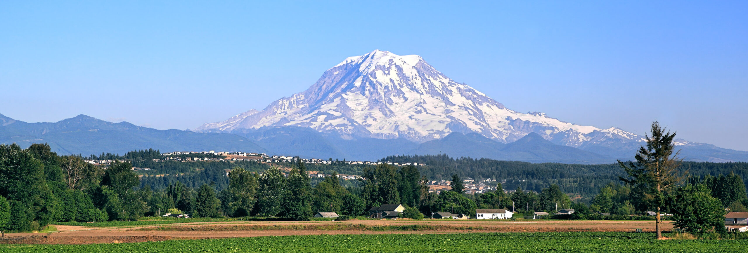
Mount Rainier rises 14,410 feet (4,392 meters) in the Cascade Range of southwestern Washington State — the highest mountain in Washington, the highest volcanic peak in the contiguous United States, and the most topographically prominent mountain in the lower 48 at 13,210 feet of prominence. Visible from Seattle 90 km away on clear days, Mount Rainier dominates the regional skyline as the iconic image of the Pacific Northwest. It is the most heavily glaciated peak in the contiguous US, containing more glacier ice than the rest of the contiguous-US mountains combined.
The Tahoma name. The Indigenous Puyallup name for the mountain is Tahoma (sometimes spelled Tacoma), meaning approximately “the mother of waters” — a direct reference to the rivers that originate from the mountain’s 25+ glaciers and flow throughout western Washington. The Yakama people call the mountain Tahoma or Tacoma with similar meaning. The Nisqually people, Puyallup people, Yakama people, and other regional tribes have visited the mountain’s lower slopes for at least 9,000 years according to archaeological evidence. The Indigenous relationship with the mountain predates European exploration by millennia and continues today — the mountain remains culturally significant to the Puyallup Tribe, the Nisqually Indian Tribe, the Yakama Nation, the Muckleshoot Indian Tribe, the Squaxin Island Tribe, and the Cowlitz Indian Tribe. Many climbers and Indigenous people prefer the name Tahoma; the federal “Mount Rainier” name has periodically been challenged but remains the official designation. Climbers should be aware of the Indigenous context when referencing the mountain.
Find Hotels, Flights & Trips for the World’s Best Hiking Destinations
The Global Summit Guide Travel Shop on Expedia — curated for outdoor adventurers, mountaineers, and serious hikers. Patagonia to the Alps. Nepal to the Rockies. Curated lodging for every region we cover.
Explore Travel Shop on Expedia →1792: George Vancouver and the “Rainier” Name
The “Mount Rainier” name was given on 8 May 1792 by British Royal Navy Captain George Vancouver, who was charting the Puget Sound coastline. Vancouver named the mountain in honor of his friend Rear Admiral Peter Rainier — a British Navy officer who never saw the mountain that bears his name. The naming was characteristic of the colonial-era practice of imposing European names on Indigenous landscapes. Vancouver’s contemporaries used both the Indigenous Tahoma name and the Rainier name interchangeably; the Rainier designation became dominant in American usage after Washington Territory’s establishment in 1853.
1855: The Disputed August Kautz Claim
The first documented serious climbing attempt was made in July 1855 by US Army Lieutenant August Kautz, then stationed at Fort Steilacoom near Tacoma. Kautz, accompanied by three soldiers, his Indigenous Nisqually guide Wapowety, and an Army surgeon, climbed via what is now called the Kautz Glacier route on the southwest side of the mountain. The party reached very high — by some accounts approximately 14,000 feet, just below the true summit. The 1855 expedition turned back before reaching the true high point, likely due to a combination of weather, time pressure, and uncertainty about the summit’s exact location in cloud.
Kautz himself never claimed to have reached the true summit, but the route he established bears his name today. His expedition is historically significant as the first documented serious mountaineering attempt on Mount Rainier and the first to demonstrate that the peak was climbable. Modern climbing historians consider the 1855 Kautz attempt to have stopped slightly below the true summit rather than reaching it.
17 August 1870: The Stevens-Van Trump First Ascent
The first verified ascent of Mount Rainier was made on 17 August 1870 by two men:
- Hazard Stevens (1842-1918) — 28 years old at the time of the ascent; son of Isaac Stevens, the first governor of Washington Territory and a Civil War general. Hazard Stevens later served as a Civil War officer himself and became a prominent Washington Territory figure.
- Philemon Beecher Van Trump (1839-1915) — 31 years old at the time; federal land agent and Washington Territory pioneer. Van Trump made multiple subsequent ascents of the mountain and became deeply associated with it; the Van Trump Glacier on the south side bears his name.
Stevens and Van Trump climbed via what is now broadly called the Gibraltar Ledges route from the Paradise side of the mountain. They were guided in part by Sluiskin, a Yakama tribesman who provided invaluable knowledge of the lower-mountain terrain but who refused to climb to the summit himself — citing Yakama spiritual beliefs that the upper mountain was sacred and not to be approached. (Sluiskin’s exact role and identity have been somewhat disputed historically; some accounts place him as Yakama, others as Klickitat or Nisqually.)
The two climbers reached the summit late in the day on 17 August 1870 and were forced to spend the night in a steam cave on the summit crater rim — a natural feature formed where geothermal heat from the still-active volcano melts ice from below, creating warm, livable cavities even at the summit. Their survival of the night in the steam cave became a defining legend of American mountaineering. They descended successfully on 18 August.
1870-1899: The Path to National Park Status
The Stevens-Van Trump first ascent in 1870 launched American mountaineering interest in Mount Rainier. Subsequent ascents through the 1870s and 1880s included Fay Fuller on 10 August 1890 — the first woman to summit Mount Rainier, and one of the first women in American mountaineering history to summit a major peak. Fuller, a 20-year-old schoolteacher, climbed in unusual gear including bloomers and rubber-soled overshoes; her ascent was widely reported and contributed to growing American interest in mountaineering.
The 1899 establishment of Mount Rainier National Park on 2 March 1899 made the mountain the 5th national park in the United States. President William McKinley signed the legislation. The new park status protected the mountain from logging, mining, and development — and established the institutional infrastructure that would eventually include the modern climbing program, the visitor centers at Paradise and Sunrise, and the network of ranger stations and trails.
1969: RMI Expeditions Founded by the Whittaker Family
The modern commercial guiding era began in 1969 with the founding of RMI Expeditions (Rainier Mountaineering, Inc.) by Lou Whittaker (1929-2024) and the Whittaker family — one of the most influential American mountaineering families. Jim Whittaker, Lou’s twin brother, had become the first American to summit Mount Everest in 1963 — and the Whittaker family used Rainier as their training ground for international expeditions throughout the 1960s-1990s. RMI Expeditions has guided more climbers up Mount Rainier than any other operator and remains one of the three NPS-authorized concessioners.
21 June 1981: The Worst Mountaineering Accident in US History
On 21 June 1981, a massive ice avalanche on the Disappointment Cleaver route killed 11 climbers when a serac (a column of glacier ice) collapsed onto a guided RMI rope team near 11,000 feet. The accident remains the worst single mountaineering accident in United States history. The victims were primarily inexperienced clients on a guided 4-day climbing course. The accident triggered substantial changes in Rainier guiding protocols, route selection, and serac monitoring — and reshaped how American commercial mountaineering manages overhead hazard.
The 1981 disaster reinforced a fundamental truth that has shaped Rainier climbing ever since: the mountain’s standard route is not safe — it is climbed despite its hazards, not because it lacks them. Modern Disappointment Cleaver guiding includes route variations to bypass identified serac hazard zones, pre-dawn climbing schedules to minimize warming-related collapse risk, and rapid-movement protocols through known hazard areas.
2000s-2025: Climate Change and Glacier Retreat
Mount Rainier’s glaciers have retreated dramatically over the past two decades. The Nisqually Glacier, the most-monitored glacier on the mountain and the principal study site for Cascades climate research, has retreated approximately 1.5 kilometers since 1857 with substantial acceleration since 2000. The Carbon Glacier — the lowest-elevation glacier in the contiguous US — has also retreated significantly. Climate change has visibly changed the mountain’s character: more open crevasses, more rockfall as previously ice-cemented slopes thaw, less reliable snow bridges, and earlier-season hazard development.
The 2025 climbing season demonstrated these trends dramatically. The public Camp Muir shelter was closed for maintenance and emergency use only from July through late September. The Disappointment Cleaver route shifted between Ingraham Direct and DC during the season as serac fall hazards evolved. By September 2025, all three major guide services had ceased operations on Disappointment Cleaver citing extreme crevasse, serac, and rockfall hazard — an unusually early shutdown that signaled accelerating late-season degradation.
The Cascade Volcanoes Anchor — Why Rainier Matters to American Mountaineering
Mount Rainier occupies a specific and central role in American mountaineering: it is the standard “first major glacier climb” for the entire United States. No other mountain in the lower 48 combines comparable altitude, glacier complexity, expedition logistics, and accessibility — and no other peak has produced as many American mountaineers building toward harder objectives.
The Rainier-to-Denali progression: The defining American mountaineering progression runs Mount Hood → Mount Baker → Mount Rainier → Denali → Aconcagua → Himalaya. Almost every American climber pursuing the Seven Summits or Himalayan expeditions has Mount Rainier in their résumé. RMI Expeditions explicitly markets its Rainier programs as preparation for higher objectives; Alpine Ascents International, IMG, and the other operators do the same. The reason is simple: Rainier teaches the operational pattern that translates directly to Denali — multi-day expedition logistics, rope-team glacier travel, alpine starts, crevasse rescue, weather management, and the discipline to turn back when conditions demand.
The Whittaker family legacy: Jim Whittaker became the first American to summit Mount Everest on 1 May 1963 — and trained for that summit on Mount Rainier. His twin brother Lou Whittaker (1929-2024) founded RMI Expeditions in 1969 and made Rainier the launching pad for American international mountaineering for the next 55 years. The Whittakers’ continuing presence — Lou’s son Peter Whittaker now leads RMI — means modern Rainier guides operate under traditions established by the people who first introduced America to Himalayan climbing.
The 1981 disaster’s continuing influence: The 21 June 1981 Disappointment Cleaver serac collapse — which killed 11 climbers in the worst US mountaineering accident in history — fundamentally shaped how American commercial mountaineering manages overhead hazard. Every Rainier guide trained after 1981 has been formed by the lessons of that accident. The protocols developed in response (route variations, serac monitoring, rapid-movement schedules through hazard zones) now extend to Denali, Aconcagua, and international expedition guiding. Rainier didn’t just produce American mountaineers — it produced the safety culture that shapes them.
For international climbers visiting Rainier: The mountain offers a different experience than European Alps classics. Less Indigenous-name-and-Catholic-clergy history; more federal-government-and-Civil-War history (the 1870 first ascent by the son of Washington Territory’s governor). Less paid-guide vs free-climbing tradition (Rainier guiding is restricted to three NPS-authorized concessioners); more glacier-and-volcano focus rather than rock-climbing focus. The contrast with Mont Blanc, the Matterhorn, or the Eiger is substantive — Rainier is American glaciated alpinism in its purest form.
Mount Rainier Historical Timeline
Archaeological evidence places the Puyallup, Nisqually, Yakama, and other Pacific Northwest peoples on the mountain’s lower slopes for at least 9,000 years. The mountain — called Tahoma (“mother of waters”) — is sacred to multiple regional tribes.
British Royal Navy Captain George Vancouver names the mountain after Rear Admiral Peter Rainier — a friend who never saw the peak. The name imposes European designation over Indigenous Tahoma terminology.
US Army Lieutenant August Kautz with Nisqually guide Wapowety and a small Army party climbs via what becomes the Kautz Glacier route. Reaches very high but generally considered to have stopped short of the true summit. First documented serious mountaineering attempt on Mount Rainier.
Hazard Stevens and Philemon Beecher Van Trump make the first verified summit, guided by Sluiskin (Yakama). They survive a night on the summit in a steam cave at the crater rim — establishing one of American mountaineering’s defining legends.
20-year-old schoolteacher Fay Fuller becomes the first woman to summit Mount Rainier, climbing in bloomers and rubber-soled overshoes. Her ascent is widely reported and contributes substantially to public interest in American mountaineering.
President William McKinley signs legislation establishing Mount Rainier National Park — the 5th national park in the United States after Yellowstone (1872), Sequoia (1890), Yosemite (1890), and General Grant (1890). 953 km² of protected area.
Jim Whittaker becomes the first American to summit Mount Everest. He trained for the climb on Mount Rainier. The Whittaker family — Jim and his twin brother Lou — become the most influential American mountaineering family of the 20th century.
Lou Whittaker founds Rainier Mountaineering, Inc. (RMI Expeditions) — establishing the modern American commercial guiding industry. RMI becomes one of three NPS-authorized concessioners and has guided more climbers up Mount Rainier than any other operator.
An ice avalanche on the Disappointment Cleaver route kills 11 climbers when a serac collapses onto a guided RMI rope team near 11,000 feet. Remains the worst single mountaineering accident in United States history. Fundamentally reshapes American commercial mountaineering safety protocols.
Alpine Ascents International, International Mountain Guides (IMG), and other operators join the NPS concessioner system. Rainier becomes the standard “first major glacier climb” for American mountaineers building toward Denali, Aconcagua, and international objectives.
Mount Rainier’s glaciers retreat dramatically. The Nisqually Glacier retreats ~1.5 km since 1857 with major acceleration after 2000. Climbing route conditions change substantially across two decades. Crevasses open earlier, snow bridges weaken faster, rockfall increases as previously ice-cemented slopes thaw.
A May 19, 2025 serac-fall event on the Ingraham Direct shifts traffic back to Disappointment Cleaver. Camp Muir public shelter closed for maintenance through late September. The season demonstrates how rapidly the mountain’s “standard” routes shift between climbing seasons.
By September 2025, all three major guide services cease operations on Disappointment Cleaver — an unusually early shutdown citing extreme crevasse, serac fall, and rockfall hazard. Large crevasses open in and around Camp Muir itself. Signals accelerating late-season degradation as a Rainier reality.
The Mount Rainier Routes
Mount Rainier has more than 20 named climbing routes. The Disappointment Cleaver and Emmons-Winthrop routes account for the substantial majority of summit ascents; harder routes like Kautz Glacier, Liberty Ridge, and Ptarmigan Ridge are climbed by experienced alpinists.
| Route | Side | Grade | First Ascent | Status |
|---|---|---|---|---|
| Disappointment Cleaver (DC) | South | Glaciated | Modern standard line | ● Open · Standard · ~75-80% of ascents |
| Ingraham Direct | South | Glaciated | Variant of DC | ● Open · Standard variant when DC closed |
| Emmons-Winthrop | NE | Glaciated | Stevens/Van Trump variants | ● Open · Less Crowded Alternative |
| Kautz Glacier | SW | Mixed | 1855 Kautz attempt (disputed) / Modern variants | ● Open · Technical Alternative |
| Liberty Ridge | North | Mixed / Technical | 1935 | ● Open · Elite Only |
| Ptarmigan Ridge | NW | Mixed / Technical | 1935 | ● Open · Elite Only |
| Gibraltar Ledges | South | Mixed | 17 Aug 1870 (Stevens/Van Trump) | ● Closed Most Years · Historic |
Disappointment Cleaver (DC) Route — The Commercial Standard
Style: Glaciated mountaineering with technical crevasse and serac hazard · Used by ~75-80% of climbers.
Approach (Day 1): From Paradise (5,400 ft / 1,646m) on the south side of the mountain, climb the Muir Snowfield approximately 4-5 hours to Camp Muir at 10,080 ft / 3,072m. Camp Muir consists of multiple stone structures including the public shelter (closed July-September 2025 for maintenance), guide-service buildings, and ranger structures. Sleep at Camp Muir.
Day 2 — Summit Push: Pre-dawn alpine start at midnight or 1 AM. From Camp Muir:
- Cowlitz Glacier (10,080 → 11,200 ft): Roped glacier travel across the Cowlitz to Ingraham Flats. ~45 minutes.
- Ingraham Flats (11,200 ft / 3,414m): Glaciated bench used as a higher camp by some teams. Cathedral Gap leads onto the Ingraham Glacier.
- Ingraham Glacier crossing (11,200 → 12,300 ft): Crosses below substantial overhead serac hazard — one of the most dangerous sections on the route. Teams move quickly.
- Disappointment Cleaver ascent (12,300 → 12,800 ft): A rocky rib between the Ingraham and Emmons Glaciers. Mixed snow and rock; some scrambling. The 1981 disaster occurred near the base of the cleaver.
- Upper mountain snow slopes (12,800 → 14,000 ft): Steep snow climbing with occasional fixed cables and rope-team movement.
- Crater rim (14,000 → 14,400 ft): The actual summit is Columbia Crest, on the rim of the active volcanic crater. Climbers traverse the crater rim (often through fumaroles releasing volcanic gas) to reach the high point.
Times: 4-6 hours up from Camp Muir to summit; 3-5 hours down. Total summit-day time: 8-12 hours from Camp Muir round-trip.
Total program: Standard commercial program is 4 days — Day 1 climbing school at Paradise/Camp Muir, Day 2 ascend to Muir, Day 3 summit push and descent to Paradise, Day 4 weather contingency or rest. 2-3 day independent programs are common.
Used by: All three NPS-authorized commercial operators (RMI Expeditions, Alpine Ascents International, IMG) plus most independent climbers.
Emmons-Winthrop Route — The Less-Crowded Alternative
Style: Sustained glaciated mountaineering on the longest glacier route in the contiguous US.
Approach: From the White River trailhead on the northeast side of the mountain, climb to Camp Schurman at 9,440 ft / 2,877m via Glacier Basin. The approach is approximately 7 km / 6 hours to Camp Schurman. Camp Schurman has a small public shelter and is operated by NPS climbing rangers during peak season.
Summit push: Climb the Emmons Glacier — the longest glacier in the contiguous US — up to approximately 13,500 ft, then climb the upper snow slopes to the summit crater. ~6-9 hours from Schurman to summit.
Why climbers choose it: The Emmons route is significantly less crowded than DC. The longer glacier travel provides a more “expedition” feel. The terrain is more open, with fewer narrow chokepoints. Camp Schurman is a smaller, more intimate climbing community than Camp Muir.
The trade-off: Longer total approach time. White River trailhead is farther from major access roads. Crevasses on the Emmons can be substantial — late-season hazard is real. The 2025 season saw rangers warning of increasing serac and rockfall risk on the Emmons as warming continued. Not a “softer option” — the Emmons is a serious glaciated climb with full Mount Rainier consequence.
Kautz Glacier — The Technical Alternative
Style: Steeper, more technical mixed climbing on the southwest side of the mountain.
Character: The Kautz Glacier route — named after the disputed 1855 Lt. August Kautz attempt — climbs the southwest side of the mountain via steeper glaciated terrain. The route includes a section of 50-55° ice climbing on the “Kautz Ice Cliff” and is significantly more technical than the DC or Emmons routes. Climbing through Paradise/Comet Falls area, then ascending through the Wilson Glacier, the Kautz Ice Cliff, and the upper snow slopes to the summit.
Modern status: Open and climbed by experienced alpinists wanting a more technical Rainier objective than the standard routes. The Kautz is among the most aesthetic climbs on the mountain. Conditions vary substantially with season; the route is most reliable in late spring / early summer.
Used by: Independent experienced parties and some commercial guides offering technical Rainier programs. Not a beginner route.
Liberty Ridge, Ptarmigan Ridge & Other Elite Routes
Liberty Ridge: First climbed in 1935 by Ome Daiber, Arnie Campbell, and Jim Borrow — one of the most aesthetic and serious lines on the mountain. The north face ridge climb involves sustained mixed climbing with substantial objective hazard from icefall and rockfall. Liberty Ridge is graded Grade III-IV alpine and remains one of the most coveted American mountaineering objectives. The route has produced several climbing fatalities over the decades and is considered elite-only.
Ptarmigan Ridge: Also first climbed in 1935 — a parallel northwest ridge to Liberty Ridge. Sustained mixed terrain; less famous than Liberty but similarly serious. Most ascents are by alpinists with significant prior experience on similar grade routes.
Gibraltar Ledges: The historic 1870 Stevens/Van Trump route on the south side. Closed most years now due to extreme rockfall hazard from the Gibraltar Rock area. Occasionally climbed in winter or shoulder seasons when frozen conditions stabilize the rockfall — but the route is generally considered too dangerous for modern summer climbing.
Modern elite status: Rainier’s harder routes (Liberty, Ptarmigan, the North face routes, Mowich Face) are climbed by perhaps 20-50 parties per year total. These routes require significant prior alpine experience — multiple comparable climbs on Mount Hood, Mount Baker, Bugaboos, or similar — and acceptance of substantially elevated objective hazard compared to the standard routes.
The Camp Muir Progression (Disappointment Cleaver Standard)
Most Mount Rainier climbs use Camp Muir as the operational base. The full Disappointment Cleaver progression:
The Camp Muir public shelter has had availability issues. The 2025 climbing season saw the public shelter closed for maintenance from July through late September, with emergency use only. Independent climbers were required to bring their own tent and sleep on the snowfield near the shelter complex. Check current NPS Climbing Conditions Reports before relying on the public shelter — facility status changes between seasons. Guide-service buildings at Camp Muir are reserved for paying clients of authorized concessioners and are not available to independent climbers.
Costs & 2026 Logistics
Mount Rainier requires a climbing permit fee plus wilderness camping permit. Commercial guiding is restricted to three NPS-authorized concessioners: RMI Expeditions, Alpine Ascents International, and International Mountain Guides (IMG). The mountain is significantly less expensive than international expedition peaks but more regulated than independent Cascade volcano climbs.
| Item | Cost | Notes |
|---|---|---|
| Mount Rainier Climbing Fee (annual) | $73 per climber | Required for all climbers above 10,000 ft / 3,048m; supports rescue/ranger operations |
| Wilderness Camping Permit (Camp Muir/Schurman) | $16-$26 | Reserved through recreation.gov; typically books 1-3 months in advance during peak season |
| Mount Rainier National Park entrance fee | $30/vehicle | Standard NPS entrance; some climbers use the America the Beautiful pass ($80/year) |
| RMI Expeditions 4-day program | $1,650-$1,750 | Most common commercial guided product; includes 4 days, gear, food, instruction |
| Alpine Ascents International 4-day program | $1,950-$2,200 | Premium tier; smaller groups; more instruction time |
| IMG (International Mountain Guides) 4-day program | $1,750-$2,000 | Established Pacific NW operator; Rainier programs and Emmons options |
| Gear rental (boots, axe, crampons, harness, helmet) | $150-$300 | Most operators offer rental packages; some clients bring own gear |
| Travel to Paradise (from Seattle, ~2 hours) | $50-$150 | Rental car or shuttle; no public transportation to Paradise |
| Pre-climb lodging (Ashford / Packwood) | $120-$300/night | Small mountain towns near park entrance; book early in peak season |
| Travel insurance (alpine coverage) | $50-$150 | Recommended; some operators require |
| Independent climber budget | $200-$400 | Climbing fee + permit + entrance + gear assumed owned |
| Guided 4-day program (standard) | $1,650-$2,200 | Most common pricing range across all three operators |
| Total trip budget (guided, including travel) | $2,500-$4,500 USD | Including international/domestic flights, gear, lodging, contingency |
Why three operators only. The National Park Service awards commercial guiding concessions through a competitive bid process roughly every 10 years. The current concession period began in 2014 and runs through 2024 (recently extended); the next concession award will likely produce some shifts but the three-operator structure is expected to continue. RMI Expeditions (founded by Lou Whittaker in 1969) has guided more climbers up Rainier than any other operator — typically 1,500-2,000 client-summits per year. Alpine Ascents International (founded by Todd Burleson) operates premium-tier programs with smaller groups and more instruction. International Mountain Guides (IMG) (founded in 1986) offers a mix of standard and harder route options. All three operators have substantial Denali, Aconcagua, and international expedition programs — Rainier is the entry point.
Permits book out fast in peak season. Wilderness camping permits for Camp Muir or Camp Schurman during July-August book out within hours of release. Recreation.gov releases permits in waves — check the NPS Mount Rainier climbing page (nps.gov/mora) for current reservation policies. Guided clients have permits handled by their operator. Independent climbers must reserve their own permits and check in at the ranger station at Paradise before starting their climb. Walk-up climbers without permits will be turned away.
Best Time to Climb & Cascade Volcano Weather
The Mount Rainier main climbing season runs from late May through mid-September, with the prime guided window typically May through July. Late-season conditions degrade rapidly — by September 2025, all three major guide services had ceased operations on Disappointment Cleaver entirely.
| Period | Window | Conditions | Watch For |
|---|---|---|---|
| Winter | December – March | Heavy snow; severe weather; technical winter routes only | Extreme cold (-30°C+ on summit); avalanche hazard; storms; only experienced winter alpinists |
| Pre-Season | April – Mid-May | Spring snow on the mountain; routes establishing; weather warming | Some routes not yet established; weather variability; lingering avalanche conditions |
| Prime Season | Late May – Mid-July | Best snow conditions on standard routes; firm snow; stable snow bridges | Crowd pressure on Camp Muir; reservation difficulty; standard climbing season |
| Mid-Season | Mid-July – August | Warmer temperatures; longer days; more crevasses open | Crevasse opening accelerates; serac fall risk rising; rockfall increases; afternoon thunderstorms |
| Late Season | September | Substantially deteriorated conditions; routes shifting; reduced guide operations | By Sept 2025: all major guides ceased DC operations; large crevasses in Camp Muir itself; only experienced parties |
The midnight start pattern. Mount Rainier summit days begin at midnight or 1 AM from Camp Muir. The very early start serves multiple purposes: (1) snow bridges on the Ingraham Glacier are firmer in pre-dawn cold, reducing crevasse hazard; (2) serac fall on the Cathedral Gap traverse is significantly less likely in cold pre-dawn temperatures; (3) afternoon thunderstorms on the Cascades are common in summer — climbers must be off the upper mountain before noon to avoid lightning risk; (4) the long ~10-hour round trip from Camp Muir requires nearly the full day. Climbers who start later than 1 AM almost always face elevated weather and hazard risk on descent.
Rainier creates its own weather. Mount Rainier is so massive — 14,410 feet rising from sea level — that it generates its own weather patterns. Lenticular clouds form over the summit even on otherwise clear days, indicating high winds aloft. Pacific storm systems hitting the Cascades produce extreme conditions on the upper mountain: winds over 100 mph, temperatures down to -30°C, and sudden whiteout conditions. The “Rainier weather forecast” must include both the NWS regional forecast AND the specific Mount Rainier National Park climbing rangers’ mountain forecast. Don’t rely on smartphone weather apps — they consistently underestimate upper-mountain conditions.
Essential Gear Checklist
Mount Rainier gear demands are full glacier mountaineering kit. The mountain’s altitude (4,392m), cold, sustained glacier travel, and crevasse rescue requirements demand the same gear that climbers will later use on Denali, Aconcagua, or international expeditions. This is what makes Rainier valuable as the standard American “first major glacier climb.”
Alpine Clothing System
- Synthetic or merino base layers (top + bottom; warm reserve set for camp)
- Mid-weight insulating layer (fleece or synthetic)
- Heavy down or synthetic insulated jacket (summit day reserve)
- Quality hardshell jacket + pants (Gore-Tex or equivalent)
- Warm beanie + buff + sun hat
- Liner gloves + insulated climbing gloves + summit mitts (heavy)
- Glacier sunglasses (Category 4) + goggles for wind/whiteouts
Footwear & Crampons
- Mountaineering boots B2-B3 (rigid): La Sportiva Trango Tower, Scarpa Mont Blanc, Salewa Crow GTX, La Sportiva G2 Evo
- Crampons with anti-balling plates (Petzl Vasak, Grivel G12, Black Diamond Sabretooth)
- Wool/synthetic socks (3 pairs) + liner socks
- Gaiters (calf-height; full glacier coverage)
- Camp shoes / down booties for Camp Muir
Glacier & Technical Hardware
- Climbing harness with full strength rating
- Climbing helmet (essential — overhead hazard real on DC and Emmons)
- Ice axe (60-65cm general-mountaineering axe)
- 3 locking carabiners + 3 standard carabiners
- Belay device + prusik cord
- 2 prusiks + cordelette for crevasse rescue
- 2 alpine slings + 1 longer sling
- Glacier rope (8-9mm × 30-50m for rope team; guide-provided)
- Personal anchors (PAS or Daisy chain)
Camp & Personal Gear
- 50-65L expedition pack (carry approach gear up; daypack from camp)
- 4-season tent (with poles for snow; if not staying in public shelter)
- Sleeping bag rated to -10°C/15°F or colder
- Sleeping pad (closed-cell foam + inflatable combo recommended)
- Stove + fuel (for melting snow + cooking)
- 1L+ insulated water bottle + electrolytes
- Trail food + summit-day energy bars/gels + extra reserves
- Sunscreen (high SPF), lip balm with SPF
- Personal first aid kit + headlamp + spare batteries
- NPS climbing pass + wilderness permit + identification
Difficulty & Why Rainier Is Different From Mont Blanc
Mount Rainier is not technically harder than Mont Blanc or the major Alps peaks — but it presents different challenges that climbers from the European tradition often underestimate. Five specific characteristics define what the mountain actually demands:
1. Glacier hazard is sustained and dynamic. Mount Rainier is the most heavily glaciated peak in the contiguous US. Every climbing route crosses substantial glacier terrain with active crevasse evolution, serac fall hazard, and snow bridge instability. The 1981 Disappointment Cleaver disaster — 11 climbers killed by a serac collapse — is the worst single US mountaineering accident in history and remains the defining cautionary tale. The mountain’s standard route is not safe — it is climbed despite its hazards, not because it lacks them. Annual death tolls average 4-6 climbers across all routes.
2. The route changes every season — sometimes every week. Unlike European Alps peaks where the standard line is largely fixed, Rainier’s standard routes are dynamic. The 2025 season saw traffic shift between Ingraham Direct and Disappointment Cleaver multiple times as serac fall hazards evolved. By September 2025, all three major guide services had ceased operations on DC entirely. Climbers must trust route condition reports from active sources — Mount Rainier National Park climbing rangers, RMI’s route conditions blog, or current guide-service updates. A “DC route” from 2020 trip reports is not the same route in 2026.
3. Rainier creates its own weather. The mountain’s massive 4,400m prominence above the surrounding terrain produces severe upper-mountain weather even when sea-level conditions look fine. Lenticular cloud caps over the summit indicate high winds aloft; Pacific storm systems hitting the Cascades produce 100+ mph wind events and temperatures below -30°C; sudden whiteouts on the upper glaciers create dangerous navigation conditions. Climbers who don’t watch the Mountain Forecast — and who don’t accept the guide’s turnaround calls — get caught.
4. The midnight alpine start is non-negotiable. Summit pushes begin at midnight or 1 AM from Camp Muir for serac fall and weather reasons. Climbers who arrive at Camp Muir expecting “a good night’s sleep before the climb” don’t sleep more than 3-4 hours regardless. The transition from sea level to 10,000 feet in 24 hours produces sleep disruption that compounds with the midnight wake-up. Most climbers’ summit day is run on minimal sleep, full glacier kit, and 10+ hours of sustained exertion. This is the operational reality that translates to Denali — and one of the reasons Rainier is such useful Denali preparation.
5. Volcanic gas at the summit is a real (mild) hazard. Mount Rainier is an active volcano — last erupted approximately 1894. The summit crater contains steam fumaroles releasing low concentrations of volcanic gases including hydrogen sulfide and carbon dioxide. The fumaroles are also what created the steam caves where Stevens and Van Trump survived the night in 1870. Modern climbers traverse the crater rim to reach Columbia Crest — usually without significant gas exposure. However, climbers with respiratory conditions should be aware of the fumarole activity. Don’t linger near active steam vents; move through the crater promptly.
What Mount Rainier rewards: Climbers with prior alpine experience on smaller glaciated peaks (Mount Hood, Mount Baker, Mount Adams, or formal alpine instruction), strong fitness for 8-12 hour summit days, comfort with sustained glacier travel and crevasse rescue, willingness to operate on minimal sleep at altitude, ability to absorb 4-7 days of weather flexibility, and acceptance of the mountain’s dynamic route reality. As preparation for Denali, the Cascade Volcanoes, Aconcagua, or international expedition climbing, Mount Rainier is excellent — and is explicitly designed by the major operators as the entry point for that progression. As preparation for harder Alps peaks like the Matterhorn or Eiger, Rainier teaches glacier and weather skills but doesn’t teach the rock-climbing exposure those peaks demand. As a “first major glaciated mountain,” Rainier is among the best choices in North America — provided climbers approach it with appropriate respect.
Featured Expedition Operators
Commercial guiding on Mount Rainier is restricted to three NPS-authorized concessioners. All three operate under National Park Service oversight, run similar 4-day programs, and provide IFMGA/AMGA-trained guides. Below are the three concessioners plus additional context.
RMI Expeditions (Rainier Mountaineering, Inc.)
Founded by Lou Whittaker in 1969, RMI is the oldest and largest Mount Rainier guide service — and has guided more climbers up the mountain than any other operator. RMI has 50+ years of Rainier expertise and runs the most comprehensive Rainier program portfolio: standard 4-day Disappointment Cleaver climbs, Emmons-Winthrop programs, Kautz Glacier technical climbs, custom programs, and Denali/international expedition operations. The Whittaker family continues to be involved — Peter Whittaker (Lou’s son) leads RMI today. rmiguides.com
Alpine Ascents International
Founded by Todd Burleson in 1986, Seattle-based Alpine Ascents operates premium-tier Mount Rainier programs with smaller group sizes (typically 1:2 client-to-guide ratios), more instruction time, and higher per-climber pricing. Strong reputation for technical preparation and structured progression toward Denali, the Seven Summits, and international expeditions. AMGA-certified guides. alpineascents.com
International Mountain Guides (IMG)
Founded in 1986, Ashford-based IMG (located in the small town nearest the Mount Rainier National Park entrance) operates a comprehensive Mount Rainier program including standard DC ascents, Emmons options, Kautz technical climbs, and seasonal Liberty Ridge attempts. AMGA-certified guides. IMG also operates significant Denali, Everest, and international programs. mountainguides.com
Whittaker Mountaineering
Family-affiliated gear and services operation associated with the Whittaker mountain legacy — provides gear rental, climbing courses, and ancillary services in Ashford. Not an NPS-authorized concessioner for the standard guided ascent, but provides infrastructure that supports the broader Mount Rainier climbing community. whittakermountaineering.com
Frequently Asked Questions
Mount Rainier rises to 4,392 meters (14,410 feet) in the Cascade Range of Washington State. It is the highest mountain in Washington, the highest volcanic peak in the contiguous United States, and the most topographically prominent mountain in the lower 48 — visible from Seattle 90 km away on clear days. The Indigenous Puyallup name for the mountain is Tahoma (sometimes spelled Tacoma), meaning approximately “the mother of waters” — a reference to the rivers that originate from the mountain’s 25+ named glaciers. The “Mount Rainier” name was given in 1792 by British explorer George Vancouver in honor of Peter Rainier.
The first verified ascent of Mount Rainier was made on 17 August 1870 by Hazard Stevens (28, son of the first governor of Washington Territory) and Philemon Beecher Van Trump (31, federal land agent) via the Gibraltar Ledges route from Paradise. They were guided in part by Sluiskin, a Yakama tribesman who refused to climb to the summit himself. Stevens and Van Trump survived a night on the summit in a steam cave at the crater rim. An earlier 1855 claim by US Army Lieutenant August Kautz reached very high on the mountain via what is now called the Kautz Glacier route but is generally considered to have stopped before the true summit. The first Indigenous ascent in modern records is also from the 1870s period — the mountain has likely been visited by Puyallup, Yakama, Nisqually, and other regional peoples for far longer than written records document.
The Disappointment Cleaver (DC) Route is the standard guided route, accounting for the substantial majority of Mount Rainier ascents. Climbers approach from Paradise (5,400 ft / 1,646m) on the south side of the mountain, climb 4-5 hours to Camp Muir at 10,080 ft / 3,072m for the first overnight. The summit push starts at midnight or 1 AM, ascends to Ingraham Flats (11,200 ft / 3,414m), crosses the Cathedral Gap, then climbs Disappointment Cleaver — a rocky rib between the Ingraham and Emmons Glaciers — before ascending steep snow slopes and the summit crater to the high point at Columbia Crest. The route is approximately 9,000 vertical feet from Paradise. Total summit-day time: 8-12 hours from Camp Muir round-trip. The exact route line changes annually as glaciers shift.
Mount Rainier has caused approximately 425 climber and skier deaths since 1897 — making it among the deadliest mountains in the United States. The June 1981 ice avalanche on Disappointment Cleaver remains the worst single mountaineering accident in US history, killing 11 climbers when a serac collapsed onto a guided rope team. Annual death tolls average 4-6 climbers per year across all routes. Primary hazards: crevasses (the mountain has 25+ glaciers with constant crevasse evolution), serac fall (the Disappointment Cleaver has overhead hanging ice), rockfall (especially in late season as glaciers retreat), avalanches in early/late season, severe weather (Rainier creates its own storms), and altitude (4,392m affects unacclimatized sea-level climbers significantly). The 2025 climbing season saw the public Camp Muir shelter closed for maintenance and major guide services ceasing operations on the DC route by September.
Guided 2026 Mount Rainier climbs typically cost $1,500-$2,800 per climber for the standard 4-day program through major operators like RMI Expeditions, Alpine Ascents International, IMG (International Mountain Guides), or Whittaker Mountaineering. The 4-day program includes climbing school, all technical gear, food, guides, and the summit push. NPS climbing fees: $73 per climber for the annual climbing pass (required for all climbers above 10,000 ft / 3,048m) plus a wilderness camping permit fee. Independent climbers can budget $200-$400 for fees, permits, and basic logistics. Total trip budget including travel to Paradise, gear rental, and weather contingency typically runs $2,500-$4,500 USD for guided climbers — substantially less than international expedition peaks but more than self-organized Cascade climbs.
The main Mount Rainier climbing season runs from late May through mid-September, with the prime guided window typically May through July. Late May and June often offer the best snow conditions — firm snow on the upper mountain with stable snow bridges. July and August have warmer temperatures but increased crevasse opening, serac fall risk, and rockfall as the glaciers warm. By September, conditions typically deteriorate substantially — by September 2025, major guide services had ceased operations on the Disappointment Cleaver route entirely, citing extreme crevasse, serac, and rockfall hazard. Early-season ascents (March-May) and winter ascents are possible but require full winter mountaineering competence and substantially elevated avalanche risk.
Yes — both climbing fees and wilderness permits are required. The Mount Rainier Climbing Fee ($73 per climber, paid through the NPS) is required for all climbers above 10,000 ft / 3,048m and supports climbing rangers and rescue operations. A wilderness camping permit is required for any overnight stay including Camp Muir or Camp Schurman — reserved through recreation.gov, typically requires reservation 1-3 months in advance during peak season. Commercial guiding is restricted to three NPS-authorized concessioners: RMI Expeditions, Alpine Ascents International, and International Mountain Guides (IMG). Independent climbers must pass through a ranger check-in at the climbing rangers’ station at Paradise before starting their climb. Group sizes are limited; party size restrictions apply.
Mount Rainier is the standard “first major glacier climb” for American mountaineers, but it is not a beginner peak in the absolute sense. Climbers should arrive with prior alpine experience (Mount Hood, Mount Baker, Mount Adams, or formal alpine instruction at minimum), strong fitness for 8-12 hour summit days, comfort with cramponing, self-arrest, and roped glacier travel, and willingness to operate on minimal sleep at altitude. Guided 4-day programs through RMI, Alpine Ascents, or IMG include climbing school instruction that brings less-experienced climbers up to the necessary skill level — making the mountain accessible to fit, motivated newcomers with the right guide support. Beginners without any alpine background should consider Mount Hood or Mount Baker as preparation peaks before attempting Rainier.
Mount Rainier sits in the Cascade Range in Washington State, approximately 90 km southeast of Seattle-Tacoma. Coordinates: 46.8523°N, 121.7603°W. The mountain is the centerpiece of Mount Rainier National Park — established 2 March 1899 as the fifth national park in the United States. The park covers 953 km² and includes the entire mountain plus surrounding forested terrain. The main climbing approach is from Paradise (5,400 ft / 1,646m) on the south side; the Emmons-Winthrop route uses the White River trailhead on the northeast side. The mountain is visible from Seattle, Tacoma, Olympia, and most of western Washington on clear days, dominating the regional skyline as the iconic image of the Pacific Northwest.
Mount Rainier Map & Paradise Weather
Mount Rainier summit coordinates: 46°51’08″N 121°45’37″W (46.8523°N, -121.7603°W). The map below shows the summit’s position in the Cascade Range. Live weather is shown for Paradise (5,400 ft / 1,646m) — the main trailhead. Summit conditions are typically 22-30°C colder than Paradise; upper-mountain wind speeds are often 3-5x higher than valley readings.
Mount Rainier Climbing Permits & Logistics Guide
Was this helpful?
🏔Related peaks nearby
🧭Explore & compare
Global Summit Guide is an independent mountaineering resource founded in 2026. The team combines first-hand trekking and climbing experience with in-depth research and professional health and nutrition review to help climbers choose objectives, prepare properly, and stay safe.
Health, altitude, and nutrition content is reviewed by Taylor Ludlow (Registered Nurse) and Brigg Hoopes (Nutritionist).
What We Don't Know Yet
Mountain information changes quickly. This box explains the limits of what this page can responsibly promise.
- Permit availability, reservation windows, quotas, and official fee rules may change after this page is updated.
- Guide-company prices, departure dates, guide ratios, included services, and cancellation rules can change without notice.
- Weather, snowpack, avalanche risk, road access, and route conditions can change quickly and may be different on your climbing dates.
- Route conditions, trailhead access, crevasse exposure, stream crossings, and rescue access may vary from published planning guidance.
- Total trip cost can change with flights, lodging, guide pricing, permits, gear rentals, transportation, and exchange rates.
Verify current conditions with official land managers, guide services, local forecasts, and current route reports before booking or climbing.
Part of this Global Summit Guide cluster
Explore the complete Mountains guide for more context, routes, planning links, and related resources.
Mountaineering, rock and ice climbing, glacier travel, and high-altitude activity are inherently dangerous and can result in serious injury or death. The information on Global Summit Guide is provided for general informational and educational purposes only and is not a substitute for professional instruction, qualified guiding, proper equipment, or your own judgment and experience.
Route conditions, weather, snowpack, permits, regulations, and hazards change constantly and may differ from what is described here. Details may be incomplete, out of date, or contain errors. Always verify current information with local authorities, certified guides, and official sources before making any decision in the mountains.
Nothing on this site is medical, legal, or financial advice. Our fitness, acclimatization, altitude, and nutrition content is general in nature; consult a qualified physician before beginning any strenuous exercise program or exposing yourself to high altitude.
You are solely responsible for your own safety and decisions. To the fullest extent permitted by law, Global Summit Guide and its team accept no liability for any loss, injury, damage, or expense arising from use of, or reliance on, this information. By using this site you acknowledge these risks and accept these terms.
Some links on this site may be affiliate links. If you buy through them we may earn a small commission at no extra cost to you; this never affects our recommendations.
Global Summit Guide recommendation path
Next Best Mountain to Research
Use these recommendations to continue the right planning path instead of stopping on one page.
Use current permit, weather, route, and operator information before booking or climbing.