
Last updated July 2, 2026
The Best Mountains to Climb in Utah: Wasatch, Uinta, La Sal & Tushar Ranges (2026)
Utah’s four major mountain ranges — Wasatch (Mount Nebo, Mount Timpanogos), Uinta (Kings Peak at 13,528ft, Utah’s highest), La Sal (Mount Peale near Moab), and Tushar (Delano Peak) — offer everything from beginner-friendly Bald Mountain to expert-level Kings Peak. This complete state guide ranks the 10 best mountains across all difficulty levels with route details, seasonal recommendations, and the protocol for choosing your first Utah climb.
Utah’s mountains are among the most underrated climbing destinations in the American West — combining 13,000-foot Uinta peaks, the iconic Wasatch Front rising directly above Salt Lake City and Provo, the La Sal Mountains rising dramatically from the desert near Moab, and the lesser-known Tushar peaks of southern Utah. Generally, Utah’s mountain landscape divides into four distinct ranges, each with its own character: the Wasatch Range running north-south past Salt Lake City and Provo (most accessible), the Uinta Mountains extending east-west across northeast Utah and containing Kings Peak at 13,528 feet (the state’s highest summit), the La Sal Mountains rising dramatically from red rock desert near Moab (Mount Peale at 12,726 feet), and the Tushar Mountains in southern Utah (Delano Peak at 12,174 feet). Specifically, Utah has zero peaks above 14,000 feet, but its 13ers in the Uintas and high Wasatch summits offer genuine high-altitude climbing experiences. Notably, this guide ranks the 10 best mountains to climb in Utah across all difficulty levels — from beginner Bald Mountain (Uinta) to expert Kings Peak — with route details, seasonal windows, and the common mistake of confusing Mount Timpanogos and Mount Nebo for Utah’s highest peak (Kings Peak holds that title at 13,528ft in the remote High Uintas).
Key Takeaways
- Kings Peak (13,528ft) is Utah’s highest mountain — located in the Uinta Mountains in the High Uintas Wilderness, requires 29-mile / 3-day backpacking trip via Henrys Fork Trail.
- Utah has zero 14ers — Kings Peak falls approximately 472 feet short of the 14,000-foot threshold; the state’s other 13ers (South Kings, Gilbert Peak, Mount Emmons) cluster in the Uintas.
- 4 major mountain ranges — Wasatch (most accessible from SLC/Provo), Uinta (highest peaks), La Sal (near Moab), Tushar (southern Utah).
- Mount Timpanogos (11,752ft) is Utah’s most-climbed serious mountain — non-technical but strenuous, 14 miles round-trip via Timpooneke Trail.
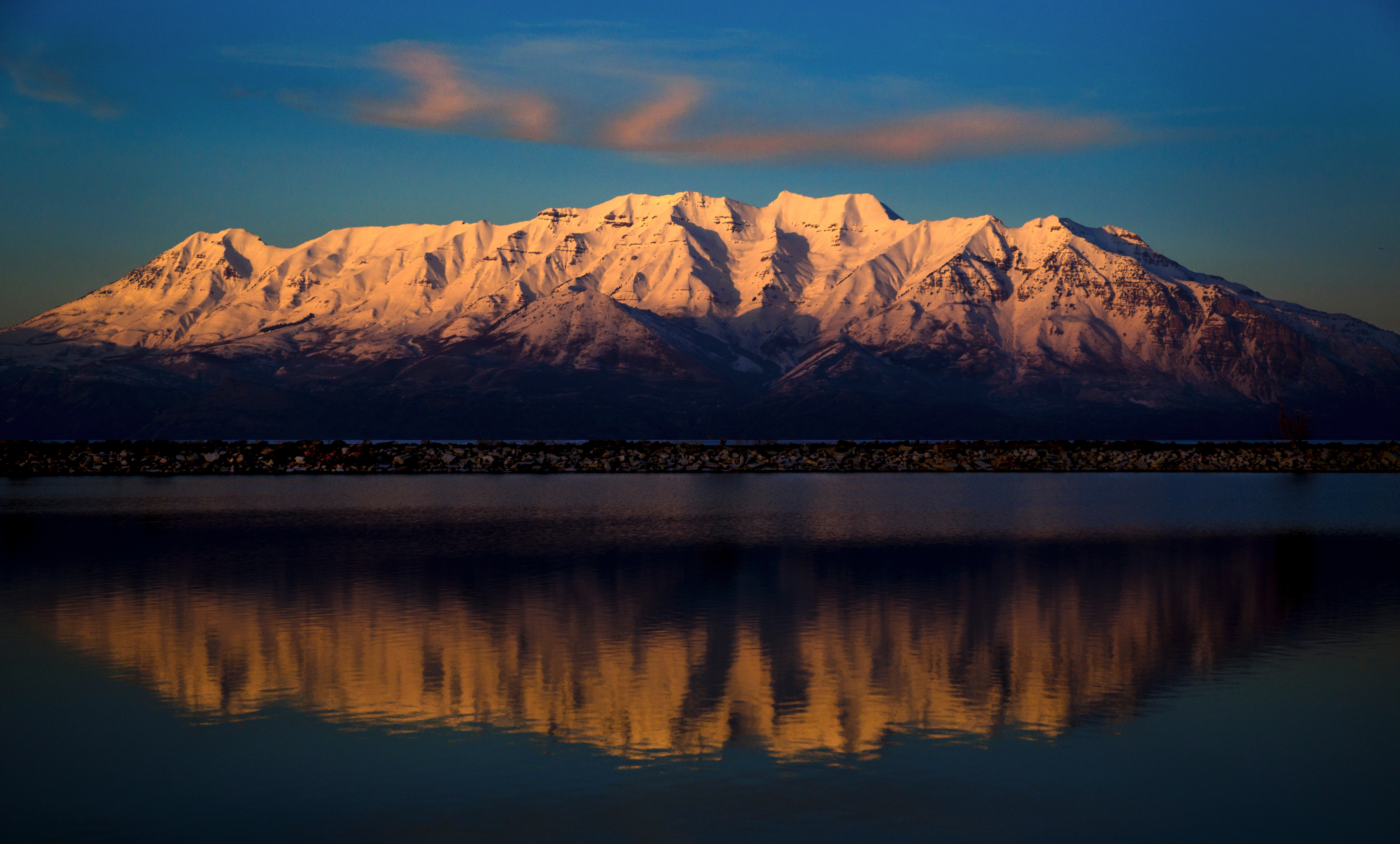
- Mount Nebo (11,928ft) is the highest peak in the Wasatch Range — often confused as Utah’s highest but Kings Peak in the Uintas is 1,600 feet higher.
- Mount Peale (12,726ft) is the highest La Sal peak — near Moab with dramatic desert-to-alpine transition.
- 4 difficulty tiers in Utah: Beginner (Bald Mountain, Ensign Peak), Moderate (Mount Timpanogos, Mount Olympus), Hard (Mount Nebo full traverse, Pfeifferhorn, Lone Peak), Expert (Kings Peak 3-day backpack).
- Best season July-September for most Utah peaks, with Uinta Mountains shifting to late June through early October due to higher elevation.
- Most Utah peaks need no special permits beyond Big/Little Cottonwood Canyon fees ($5/day) and trailhead access — Utah remains one of America’s most accessible mountain states.
Why Climb in Utah?
Utah is one of America’s most underrated mountain climbing destinations — combining four distinct ranges, accessible peaks within an hour of major urban centers, and a complete progression pathway from beginner walk-ups to expert multi-day expeditions, all within state borders. Generally, Utah’s mountain landscape divides into four genuinely different ranges with distinct character, climbing culture, and peak selection: the Wasatch Range running north-south past Salt Lake City and Provo (the most accessible high mountains in the American West for a metropolitan population), the Uinta Mountains extending east-west across northeast Utah and containing Utah’s highest peak (Kings Peak at 13,528ft), the La Sal Mountains rising dramatically from red rock desert near Moab (Mount Peale at 12,726ft offering an unforgettable desert-to-alpine transition), and the Tushar Mountains in southern Utah (Delano Peak at 12,174ft providing less-crowded high-altitude climbing). Specifically, climbers can complete a full mountaineering progression entirely within Utah — starting with beginner-friendly Bald Mountain in the Uintas, advancing through Mount Olympus and Mount Timpanogos in the Wasatch, building experience on Mount Nebo and the harder Wasatch peaks, and ultimately tackling Kings Peak as a 3-day expedition. Notably, Utah is one of America’s most accessible mountain states from a permit perspective — most peaks require no special permits beyond Big and Little Cottonwood Canyon fees ($5/day) and standard trailhead access, in contrast to states like Washington and Alaska where permits and fees can substantially complicate climbing logistics.
The 4 Utah Mountain Ranges
Utah’s climbable mountains organize into four major ranges, each with distinct character and peak selection. Generally, climbers should consider not just individual peaks but which range matches their travel base, aesthetic preferences, and experience level. Specifically, the Wasatch is most accessible from urban Utah, the Uinta Mountains hold the state’s highest peaks, the La Sal Mountains offer dramatic desert-to-alpine landscapes, and the Tushar Mountains provide less-crowded high-altitude climbing in southern Utah.
Find Hotels, Flights & Trips for the World’s Best Hiking Destinations
The Global Summit Guide Travel Shop on Expedia — curated for outdoor adventurers, mountaineers, and serious hikers. Patagonia to the Alps. Nepal to the Rockies. Curated lodging for every region we cover.
Explore Travel Shop on Expedia →The Wasatch Range is Utah’s most famous and most accessible mountain system — running approximately 160 miles north-south from southern Idaho through northern Utah, with Mount Nebo (11,928ft) as its highest peak near Nephi in the southern Wasatch. Generally, the Wasatch is the defining mountain landscape for Utah’s population — roughly 80% of Utah residents live along the Wasatch Front, the western edge of the range, putting some of America’s most accessible high mountains within an hour of major population centers. Specifically, the range includes iconic peaks: Mount Nebo (11,928ft, southern Wasatch highest), Mount Timpanogos (11,752ft, second-highest and most-climbed), Lone Peak (11,253ft), Pfeifferhorn (11,326ft), Twin Peaks (11,330ft, Salt Lake County highpoint), Mount Olympus (9,026ft, iconic SLC peak), Box Elder Peak (11,101ft), and many others. Notably, the Wasatch is renowned for its accessibility — five canyons (Mill Creek, Big Cottonwood, Little Cottonwood, Parleys, American Fork) provide access to dozens of climbable peaks within 30 minutes of Salt Lake City, supporting one of America’s most active urban mountaineering cultures.
The Uinta Mountains hold Utah’s highest peaks and are unusual among major American ranges in their east-west orientation. Generally, the Uinta range extends approximately 150 miles across northeast Utah and into Wyoming, containing the High Uintas Wilderness — one of the largest protected wilderness areas in Utah at approximately 460,000 acres. Specifically, the range includes Utah’s highest summit (Kings Peak at 13,528ft) plus multiple adjacent 13ers: South Kings Peak (13,512ft), Gilbert Peak (13,442ft), Mount Emmons (13,440ft), Gunsight Peak (13,263ft), and Wilson Peak (13,221ft). Notably, the Uintas offer something rare in American mountaineering — beginner access to genuine alpine terrain via Mirror Lake Highway, which crosses the western Uintas at 10,700 feet and provides trailheads for accessible high peaks including Bald Mountain (11,943ft, 2-mile round-trip). The range is also home to over 1,000 alpine lakes and the longest non-Sierra wilderness backpacking system in the western USA.
The La Sal Mountains rise dramatically from the red rock desert of eastern Utah near Moab — creating one of America’s most distinctive climbing contrasts where 12,000-foot alpine peaks loom over 4,000-foot canyon country. Generally, the La Sals are the second-highest mountain range in Utah after the Uintas, containing Mount Peale (12,726ft, the range’s highest), Mount Mellenthin (12,646ft), Mount Tukuhnikivatz (12,482ft), and Manns Peak (12,272ft). Specifically, the standard climbing route for Mount Peale is a moderately strenuous but non-technical hike via Geyser Pass and the south ridge — approximately 8-10 miles round-trip with substantial elevation gain. Notably, La Sal climbing combines mountaineering with proximity to Moab’s national parks (Arches, Canyonlands), making the area popular for climbers wanting to combine alpine summits with red rock landscape exploration. The range is far less crowded than the Wasatch and offers a genuinely different aesthetic experience from Utah’s other ranges.
The Tushar Mountains are Utah’s third-highest range — a compact volcanic range in southern Utah near Beaver, with Delano Peak (12,174ft) as its highest summit. Generally, the Tushars are far less famous than the Wasatch and Uintas but offer high-quality high-altitude climbing with substantially less crowding than the Wasatch peaks near Salt Lake City. Specifically, the range includes Delano Peak (12,174ft), Mount Belknap (12,139ft), Mount Baldy (12,082ft), and others — all of which can be climbed as moderately strenuous day hikes from trailheads accessed via Beaver, Utah. Notably, the Tushar Mountains are particularly attractive for southern Utah climbers — accessible from Cedar City, St. George, and the I-15 corridor, providing high-elevation climbing options for visitors to Bryce, Zion, and Capitol Reef who want to add genuine alpine summits to their southern Utah trip.
The 10 Best Mountains to Climb in Utah
The 10 peaks below represent the best climbing in Utah across all four ranges and four difficulty levels. Generally, climbers should match peak selection to their experience and available time — Bald Mountain takes 2 hours from a high trailhead, while Kings Peak requires 3 days of backpacking. Specifically, the rankings consider summit quality, difficulty appropriate to the tier, route quality, and overall climbing significance within Utah’s mountaineering culture.
Kings Peak is Utah’s highest mountain and the focal objective for climbers completing Utah’s state highpoint or pursuing Utah’s 13ers. Generally, the standard route is the Henrys Fork Trail — a 29-mile round-trip backpacking trip typically completed over 3 days with overnight camps at Dollar Lake or Painter Basin. Specifically, the route crosses Gunsight Pass and Anderson Pass before the final boulder field summit scramble — a technically straightforward Class 2-3 ascent that becomes serious in poor weather. Notably, Kings Peak is genuinely remote — the Henrys Fork Trailhead is approximately 4-5 hours drive from Salt Lake City, and the round-trip commitment makes this a substantial multi-day expedition rather than a day climb. Most climbers attempt Kings Peak in July or August when snow has cleared from the upper boulder fields and weather windows are most reliable.
Mount Timpanogos is Utah’s most iconic and most-climbed serious mountain — a 7,000-foot prominence above Utah Valley that defines the Wasatch skyline from Lehi south through Provo. Generally, two standard trails reach the summit: the Timpooneke Trail (7.5 miles one-way, ~4,500ft gain) and the Aspen Grove Trail (7 miles one-way, ~4,850ft gain), converging at the saddle approximately 1.5 miles below the summit. Specifically, both routes are non-technical hiking with no climbing required, though the final summit pyramid involves brief rocky terrain. Notably, Mount Timpanogos hosts Utah’s only remaining glacier — a small but persistent snow and ice field on the northeast face popular for descent via glissade. Most ascents take 8-12 hours round-trip, making this a long but achievable day hike for fit climbers acclimatized to altitude.
Mount Nebo is the highest peak in the Wasatch Range — a dramatic triple-summit massif rising above Nephi at the southern terminus of the Wasatch. Generally, the standard North Summit route via the Monument Trailhead is a moderate hike of approximately 8 miles round-trip with 3,800 feet of elevation gain, while the full Three-Summit Traverse (visiting North, Middle, and South summits) is a more committing 12+ mile day requiring 3rd class scrambling. Specifically, the North Summit holds the highest elevation at 11,928 feet, though the South Summit at 11,877 feet has its own dedicated trail and prominence sufficient to count as a separate summit. Notably, Mount Nebo is commonly misidentified as Utah’s highest peak — it’s the highest in the Wasatch Range but approximately 1,600 feet lower than Kings Peak in the Uintas. The mountain offers expansive views across Utah Valley, the Wasatch Plateau, and into central Utah.
Mount Peale is the highest peak in the La Sal Mountains and offers Utah’s most dramatic desert-to-alpine climbing experience. Generally, the standard route is via Geyser Pass and the south ridge — approximately 8-10 miles round-trip with substantial elevation gain through alpine basins and along ridgeline terrain. Specifically, the climb starts in aspen and conifer forest, transitions through subalpine meadows, and finishes on rocky high-altitude terrain with views extending across Canyonlands National Park, the Manti-La Sal National Forest, and into Colorado on clear days. Notably, the La Sal Mountains are dramatically less crowded than the Wasatch peaks — Mount Peale rarely sees more than a dozen climbers on any given day even in prime season, making this an excellent choice for climbers wanting solitude alongside the dramatic landscape contrast that makes the La Sals unique.
Delano Peak is the highest summit in the Tushar Mountains — Utah’s third-highest mountain range located in southern Utah near Beaver. Generally, the standard route is a relatively short but high-elevation hike from the Big John Flat or Mud Lake trailheads — typically 4-6 miles round-trip with manageable elevation gain. Specifically, the Tushar Mountains are a volcanic range with rounded summits and open alpine terrain, making for non-technical hiking on Delano Peak and adjacent summits including Mount Belknap (12,139ft) and Mount Baldy (12,082ft). Notably, the Tushars are dramatically less famous than the Wasatch and Uintas but offer outstanding climbing for southern Utah-based climbers and visitors combining national park trips (Bryce, Zion, Capitol Reef) with mountain climbing — Delano Peak is approximately 90 minutes from Cedar City and 3 hours from St. George.
Lone Peak is one of the most demanding day-hike summits in the Wasatch Range — a 15-mile round-trip climb with approximately 5,500 feet of elevation gain from low starting elevations. Generally, the Jacobs Ladder Trail via Corner Canyon (above Draper) is the most common Salt Lake County access, with the Lone Peak Couloir route from Bell’s Canyon offering a more direct but harder line. Specifically, the upper terrain involves Class 3 scrambling on the granite summit pillar, with sustained exposure and significant route-finding challenges. Notably, Lone Peak is dramatically underestimated based on its modest 11,253-foot elevation — the combination of long approach, sustained elevation gain from low starting elevations, exposed upper scrambling, and full mountaineering commitment makes this a peak that defeats many fit hikers who attempt it without proper preparation. Plan a minimum 10-14 hour day with 4-5 liters of water minimum.
The Pfeifferhorn is Utah’s premier Class 3 scrambling objective — a dramatic ridge peak accessed via Little Cottonwood Canyon. Generally, the standard route from White Pine Trailhead is approximately 10 miles round-trip with 4,500 feet of elevation gain, finishing with several hundred feet of exposed Class 3 scrambling on the summit ridge. Specifically, the climbing isn’t difficult by technical climbing standards (no roped climbing required) but the exposure is genuine and the consequences of falls are severe — many hikers turn back at the start of the summit ridge after assessing the exposure. Notably, the Pfeifferhorn is one of the best summits in Utah for transitioning from hiking to alpine scrambling — a logical step between standard trail hiking peaks (Timpanogos, Mount Olympus) and more demanding alpine objectives (Lone Peak, Kings Peak).
Twin Peaks (South) is the highest peak entirely within Salt Lake County and a serious objective in the Wasatch wilderness above Big Cottonwood Canyon. Generally, the standard route via the Broads Fork approach is approximately 13 miles round-trip with 5,500 feet of elevation gain, combining sustained hiking with Class 2-3 scrambling on the upper sections. Specifically, the route follows Broads Fork past the famous Lake Blanche viewpoint, then ascends steep terrain to gain the summit ridge. Notably, Twin Peaks is sometimes confused with American Fork Twin Peaks (11,433ft on the SLC/Utah County border) — South Twin Peaks at 11,330ft holds the title of highest peak entirely within Salt Lake County. The climbing is comparable to Lone Peak in commitment though somewhat less technically demanding.
Mount Olympus is Salt Lake City’s most iconic mountain — a dramatic peak rising directly above the eastern Salt Lake Valley with one of the most accessible summit hikes among major Wasatch peaks. Generally, the standard route via the Olympus Trail is approximately 7 miles round-trip with 4,200 feet of elevation gain, taking most hikers 6-8 hours. Specifically, the trail is sustained steep hiking throughout with a final 0.3-mile scramble to the summit involving Class 2 rocky terrain. Notably, Mount Olympus is dramatically underestimated by visitors who see it from the valley floor and assume the short distance translates to easy climbing — the 4,200 feet of elevation gain over 3.5 miles makes this one of the steepest sustained climbs in the central Wasatch. Most SLC locals consider it the proving-ground peak before attempting harder objectives like Lone Peak or the Pfeifferhorn.
Bald Mountain is Utah’s best beginner-friendly high-altitude summit — a genuine 11,943-foot peak reached via a 2-mile round-trip trail from a 10,700-foot trailhead along Mirror Lake Highway. Generally, the math is unusual: climbers gain only approximately 1,200 feet of elevation (manageable for most reasonably fit hikers) but reach a true high-alpine summit with views across the western Uintas, the Wasatch Front to the west, and into Wyoming to the north. Specifically, the trail is well-maintained, signed, and non-technical — appropriate for fit beginners without scrambling experience. Notably, the trailhead at 10,700 feet itself represents genuine altitude exposure, so flatland visitors should plan for some adjustment time even on this “easy” peak. Bald Mountain is also an excellent acclimatization summit for climbers preparing for harder Utah objectives like Kings Peak or Wasatch full-day hikes.
Quick Comparison Table
| # | Peak | Elevation | Range | Distance | Difficulty |
|---|---|---|---|---|---|
| 1 | Kings Peak | 13,528ft | Uinta | 29 mi RT (3 days) | Expert |
| 2 | Mount Timpanogos | 11,752ft | Wasatch | 14-15 mi RT | Moderate |
| 3 | Mount Nebo | 11,928ft | Wasatch | 8 mi RT | Hard |
| 4 | Mount Peale | 12,726ft | La Sal | 8-10 mi RT | Hard |
| 5 | Delano Peak | 12,174ft | Tushar | 4-6 mi RT | Moderate-Hard |
| 6 | Lone Peak | 11,253ft | Wasatch | 15 mi RT | Hard |
| 7 | Pfeifferhorn | 11,326ft | Wasatch | 10 mi RT | Hard (Class 3) |
| 8 | Twin Peaks (S) | 11,330ft | Wasatch | 13 mi RT | Hard |
| 9 | Mount Olympus | 9,026ft | Wasatch | 7 mi RT | Moderate |
| 10 | Bald Mountain | 11,943ft | Uinta | 2 mi RT | Beginner |
Want more Utah peakbagging? See our dedicated guides to the Utah 13ers (Uinta high peaks above 13,000ft), Wasatch Range Peaks (full inventory of climbable Wasatch summits), and Utah Range Highpoints (the highest peak in each Utah mountain range).
How to Choose Your First Utah Mountain
Choosing the right Utah peak combines honest experience assessment, geographic preference (which range), available time, and season. Generally, climbers should follow the 4-step protocol below rather than selecting peaks based on social media or convenience. Specifically, the protocol prevents the most common Utah climbing mistakes: underestimating Mount Olympus and Lone Peak based on modest summit elevations, overestimating Mount Nebo or Timpanogos as Utah’s highest peak (Kings Peak holds that title), and attempting Kings Peak without multi-day backpacking experience.
The 4-Step Protocol for Choosing Your First Utah Mountain
- Identify your honest experience level. Beginners: Bald Mountain (Uinta, 2-mile RT from high trailhead), Ensign Peak (1-mile RT SLC), drive-up summits via Mirror Lake Highway. Intermediate: Mount Timpanogos (14 mi RT via Timpooneke), Mount Nebo (8 mi RT via Monument Trailhead), Delano Peak (4-6 mi RT). Hard: Mount Nebo all-three-summit traverse, Lone Peak, Pfeifferhorn class 3 scramble. Expert: Kings Peak (29 mi RT 3-day backpack), winter ascents of Wasatch peaks.
- Choose your range based on travel base. Wasatch Range — most accessible from Salt Lake City and Provo (Timpanogos, Nebo, Olympus, Lone Peak, Pfeifferhorn). Uinta Mountains — northeast Utah, requires 2-4 hour drive from urban Utah but contains Kings Peak plus Bald Mountain. La Sal Mountains — eastern Utah near Moab, Mount Peale, ideal for climbers combining mountaineering with Arches/Canyonlands National Park visits. Tushar Mountains — southern Utah, Delano Peak, accessible from Cedar City and St. George.
- Match difficulty to your skills honestly. Don’t pick Utah peaks beyond your experience — the Wasatch peaks have killed inexperienced hikers in surprise weather and difficult terrain. Use the 4-tier system: Beginner (Bald Mountain, Ensign Peak), Moderate (Mount Olympus, Mount Timpanogos), Hard (Mount Nebo, Lone Peak, Pfeifferhorn, Twin Peaks, Mount Peale), Expert (Kings Peak 3-day backpack). Build experience progressively rather than jumping difficulty tiers.
- Plan around season and access. Wasatch Range: July-September prime (snow lingers into June on north aspects). Uinta Mountains: late June through early October. La Sal Mountains: May-October (longest season). Tushar Mountains: June-October. Check Big and Little Cottonwood Canyons fees ($5/day in summer). Kings Peak requires Henrys Fork trailhead access and 3-day backpacking permit. Most Utah peaks need no special permits beyond canyon fees and trailhead access — check current regulations with the Uinta-Wasatch-Cache National Forest before climbing.
Common Mistakes Utah Climbers Make
Avoid These Common Utah Mountaineering Mistakes
- Assuming Mount Timpanogos or Mount Nebo is Utah’s highest peak. Kings Peak in the Uinta Mountains at 13,528ft is Utah’s highest summit — approximately 1,600 feet higher than Mount Nebo (11,928ft, highest in the Wasatch). The confusion happens because Timpanogos and Nebo are visible from major population centers while Kings Peak is in the remote High Uintas.
- Underestimating Mount Olympus based on its modest elevation. At 9,026 feet, Mount Olympus appears moderate, but 4,200 feet of sustained elevation gain over 3.5 miles makes it one of the steepest hikes in the central Wasatch. Many fit hikers turn back without summiting.
- Attempting Lone Peak without preparation. Lone Peak at 11,253ft is dramatically underestimated — 15 miles round-trip with 5,500 feet of gain from low elevation, plus Class 3 exposed scrambling on the summit pillar. Plan a 10-14 hour day minimum.
- Visiting the Uintas without altitude preparation. Even “easy” Uinta peaks like Bald Mountain start at 10,700 feet — sea-level visitors commonly experience altitude effects on this 2-mile round-trip hike. Spend 1-2 days at altitude before attempting Kings Peak.
- Treating the Pfeifferhorn as a hike. The Pfeifferhorn involves exposed Class 3 scrambling on its summit ridge — not technical climbing but genuine consequence terrain. Hikers without scrambling experience routinely turn back at the start of the summit ridge.
- Underestimating Cottonwood Canyon weather. Both Big and Little Cottonwood Canyons experience rapid afternoon thunderstorm development from mid-July through early September. Plan summit arrivals before noon to avoid lightning exposure on Wasatch peaks.
- Ignoring the dog restrictions in Little Cottonwood Canyon. Little Cottonwood is a watershed protection area — no dogs permitted anywhere in the canyon. Plan dog-friendly hikes for Mill Creek Canyon (odd-day/even-day off-leash system) or Big Cottonwood Canyon trails.
- Driving to Kings Peak trailhead without time buffer. The Henrys Fork Trailhead is approximately 4-5 hours from Salt Lake City — many climbers underestimate the drive and arrive at the trailhead too late to start the approach. Plan to arrive the day before and camp at the trailhead.
What We Don’t Know
Honest limitations of any Utah mountain guide
The 10 peaks featured represent a curated selection, not Utah’s full mountain inventory. Utah has hundreds of climbable peaks across its four major ranges plus many minor ranges (Stansbury Mountains, Oquirrh Mountains, Bear River Range, Henry Mountains, Abajo Mountains). The 10 peaks selected reflect mountaineering significance and accessibility rather than exhaustive coverage. Climbers exploring beyond the top 10 should consult our dedicated Utah 13ers, Wasatch Range Peaks, and Utah Range Highpoints resources.
Conditions change. Trail closures, canyon fee changes, permit system updates, and seasonal variation all affect Utah mountain climbing. Information current as of June 2026 may shift — check current conditions through the Uinta-Wasatch-Cache National Forest, Ashley National Forest (for Uintas), or Manti-La Sal National Forest (for La Sal Mountains) before committing to any specific climb.
Difficulty ratings reflect typical conditions. The 4-tier difficulty system reflects standard-route difficulty in good summer conditions. Actual difficulty shifts substantially with weather, snow conditions, group experience, and individual factors. Winter ascents of Utah peaks are genuinely possible but require winter mountaineering skills and equipment — multiple climbers have died on Wasatch peaks attempting winter ascents without proper preparation.
Mount Nebo elevation conflicts across sources. Mount Nebo’s official elevation appears as 11,928ft in USGS data and Wikipedia, though some sources list 11,933ft or 11,935ft. The 11,928ft figure is used in this guide as the most widely cited official elevation, but climbers may encounter the slightly higher figure in other sources. The difference doesn’t affect Mount Nebo’s status as the highest Wasatch peak.
Class 3 scrambling assessments are subjective. Routes described as “Class 3 scrambling” (Pfeifferhorn summit ridge, Mount Nebo three-summit traverse, Lone Peak summit pillar) involve exposure that some climbers consider harder than the technical rating suggests. Climbers uncomfortable with exposure should consider these peaks more carefully than the Class 3 rating implies, or build experience on less-exposed scrambling first.
Utah Mountain FAQ
What is the highest mountain in Utah?
Kings Peak (13,528 feet / 4,123 meters) is the highest mountain in Utah, located in the Uinta Mountains in the northeast corner of the state within the High Uintas Wilderness. Kings Peak is substantially higher than Utah’s next-highest peaks — South Kings Peak (13,512ft) and Gilbert Peak (13,442ft) are adjacent summits, while the highest Wasatch Range peak (Mount Nebo at 11,928ft) is approximately 1,600 feet lower. Kings Peak is climbed via the standard Henrys Fork Trail — a 29-mile round-trip backpacking trip typically completed over 3 days. Many Utah residents incorrectly assume Mount Timpanogos or Mount Nebo is the state’s highest peak because they are more visible from major population centers — but Kings Peak in the remote Uintas holds the title.
How many 14ers are in Utah?
Utah has zero 14ers — no mountains in Utah reach 14,000 feet in elevation. Utah’s highest peak is Kings Peak at 13,528 feet, which falls approximately 472 feet short of the 14,000-foot threshold that defines a 14er. Utah does have multiple 13ers (peaks above 13,000 feet) concentrated in the Uinta Mountains — Kings Peak, South Kings Peak, Gilbert Peak, Mount Emmons, Gunsight Peak, and others. Only five states have 14ers: Colorado (53), California (12), Washington (3), Wyoming (2), and Alaska. Utah’s highest peaks are genuine high altitude climbing but don’t qualify for 14er status.
What are the main mountain ranges in Utah?
Utah has four major mountain ranges relevant to climbing. The Wasatch Range is the most accessible — running from southern Idaho through northern Utah past Salt Lake City and Provo, with Mount Nebo (11,928ft) as its highest peak. The Uinta Mountains run east-west across northeastern Utah and contain Kings Peak at 13,528 feet — Utah’s highest summit. The La Sal Mountains rise from the desert near Moab in eastern Utah, with Mount Peale (12,726ft) as the highest. The Tushar Mountains are a smaller but high-elevation range in southern Utah, with Delano Peak (12,174ft) as the highest. Utah also has many minor ranges including the Stansbury Mountains, Oquirrh Mountains, Henry Mountains, Abajo Mountains, and Bear River Range.
What are the best mountains to climb in Utah?
The best mountains to climb in Utah span four ranges and all difficulty levels: Kings Peak (13,528ft — Utah’s highest), Mount Timpanogos (11,752ft — most-climbed), Mount Nebo (11,928ft — highest in Wasatch), Mount Peale (12,726ft — highest in La Sal), Delano Peak (12,174ft — highest in Tushar), Lone Peak (11,253ft), Pfeifferhorn (11,326ft — Class 3), Twin Peaks (11,330ft — SLC County highest), Mount Olympus (9,026ft — iconic SLC peak), and Bald Mountain (11,943ft — beginner-friendly Uinta summit). Climbers should match peak selection to experience — Bald Mountain or Mount Olympus for beginners, Mount Timpanogos for moderate hikers, Kings Peak as a multi-day commitment, and Lone Peak or Pfeifferhorn for technically capable climbers.
How hard is Mount Timpanogos?
Mount Timpanogos is a strenuous but non-technical day hike — appropriate for fit hikers without climbing experience but demanding because of its substantial distance and elevation gain. The two standard routes are the Timpooneke Trail (7.5 miles one-way, ~4,500ft gain) and the Aspen Grove Trail (7 miles one-way, ~4,850ft gain), with most hikers taking 8-12 hours round-trip. The trails are well-maintained with no technical climbing required, though the final summit approach involves a short rocky scramble. Mount Timpanogos at 11,752 feet represents genuine high altitude exposure — sea-level visitors without acclimatization commonly experience altitude effects on the summit.
When is the best time to climb mountains in Utah?
The best time to climb most Utah mountains is July through September. The Wasatch Range opens up in early July as snow clears from upper trails (though north aspects can hold snow into late July), with prime conditions through September. The Uinta Mountains have a shorter season due to higher elevation — late June through early October, with Kings Peak typically requiring conditions in July or August. The La Sal Mountains have the longest season — May through October. The Tushar Mountains follow June-October. Winter ascents of many Utah peaks are possible but require avalanche awareness, winter mountaineering skills, and equipment — multiple hikers have died on Wasatch peaks in winter conditions.
Sources and Methodology
Numbered Source References
This Utah guide synthesizes data from federal land management authorities, USGS topographic records, and Utah-specific climbing resources.
- USGS topographic and elevation data. United States Geological Survey — official source for peak elevations referenced throughout this guide, including Kings Peak (13,528ft) and all Utah peak elevations.
- Uinta-Wasatch-Cache National Forest. USFS — official authority for Wasatch Range trails, Big and Little Cottonwood Canyon fees, and Uinta Mountains access.
- Ashley National Forest. Official authority for Kings Peak and High Uintas Wilderness — Henrys Fork Trailhead access and backpacking regulations.
- Manti-La Sal National Forest. Official authority for La Sal Mountains including Mount Peale, plus Tushar Mountains coverage.
- Utah Geological Survey. Authoritative source for Utah mountain range classifications and the Wasatch Range as part of the Rocky Mountains.
- SummitPost and PeakVisor. Climbing community databases for Utah peak rankings, route information, and historical climbing data.
- Internal Global Summit Guide research. Cross-referenced with site coverage including Wasatch Range Peaks, Utah 13ers, Utah Range Highpoints, Salt Lake County Top 10 Peaks, Best Mountains Near Salt Lake City, Kings Peak via Henrys Fork trip report, and the USA Mountain Hub.
Methodology note. Quarterly review cycle — next review September 2026 (post-summer climbing season).
Continue Your Utah Mountain Research
Utah Offers Complete Mountaineering Progression
Generally, Utah’s four ranges offer the full mountaineering progression — beginner Bald Mountain in the Uintas, iconic Mount Timpanogos and Mount Olympus in the Wasatch, challenging Mount Nebo and Lone Peak, and expert Kings Peak as a multi-day expedition. Specifically, the state has zero 14ers but Kings Peak at 13,528 feet represents genuine high-altitude climbing. Notably, Utah is one of America’s most accessible mountain states — most peaks need no special permits beyond standard trailhead and canyon fees.
← Back to USA Mountain HubWas this helpful?
🏔Related peaks nearby
🧭Explore & compare
Global Summit Guide is an independent mountaineering resource founded in 2026. The team combines first-hand trekking and climbing experience with in-depth research and professional health and nutrition review to help climbers choose objectives, prepare properly, and stay safe.
Health, altitude, and nutrition content is reviewed by Taylor Ludlow (Registered Nurse) and Brigg Hoopes (Nutritionist).
What We Don't Know Yet
Mountain information changes quickly. This box explains the limits of what this page can responsibly promise.
- Route conditions, snowpack, closures, and weather can change quickly after this page is updated.
- Permit rules, fees, quotas, and reservation windows may change between review cycles.
- Operator availability, pricing, guide ratios, and cancellation terms can change by season.
- Your fitness, altitude response, risk tolerance, and experience level may change what is safe or realistic.
- Use this page for planning guidance, then verify current information with official sources and qualified local experts before committing.
Verify current conditions with official land managers, guide services, local forecasts, and current route reports before booking or climbing.
Part of this Global Summit Guide cluster
Explore the complete USA Peakbagging Challenges guide for more context, routes, planning links, and related resources.
Mountaineering, rock and ice climbing, glacier travel, and high-altitude activity are inherently dangerous and can result in serious injury or death. The information on Global Summit Guide is provided for general informational and educational purposes only and is not a substitute for professional instruction, qualified guiding, proper equipment, or your own judgment and experience.
Route conditions, weather, snowpack, permits, regulations, and hazards change constantly and may differ from what is described here. Details may be incomplete, out of date, or contain errors. Always verify current information with local authorities, certified guides, and official sources before making any decision in the mountains.
Nothing on this site is medical, legal, or financial advice. Our fitness, acclimatization, altitude, and nutrition content is general in nature; consult a qualified physician before beginning any strenuous exercise program or exposing yourself to high altitude.
You are solely responsible for your own safety and decisions. To the fullest extent permitted by law, Global Summit Guide and its team accept no liability for any loss, injury, damage, or expense arising from use of, or reliance on, this information. By using this site you acknowledge these risks and accept these terms.
Some links on this site may be affiliate links. If you buy through them we may earn a small commission at no extra cost to you; this never affects our recommendations.
Global Summit Guide recommendation path
Next Best Mountain to Research
Use these recommendations to continue the right planning path instead of stopping on one page.
Use current permit, weather, route, and operator information before booking or climbing.