
Last updated June 2, 2026
The Best Mountains to Climb in Wyoming: Grand Teton, Gannett Peak & The Wind River Range (2026)
Wyoming’s five mountain ranges offer some of America’s most technical alpine objectives — Gannett Peak (13,809ft, Wyoming’s highest in the remote Wind River Range), Grand Teton (13,775ft, the iconic 5.4 technical rock summit), Mount Moran, Cloud Peak (Bighorns), and the famous Devils Tower. This complete state guide ranks the 10 best Wyoming peaks across all difficulty levels with route details, range breakdowns, and the protocol for choosing your first Wyoming objective.
Wyoming offers some of America’s most technically demanding and most remote mountain climbing — defined not by elevation (Wyoming has zero 14ers) but by character, technical commitment, and wilderness experience. Generally, Wyoming’s mountain landscape divides into five distinct ranges: the Teton Range with its dramatic alpine rock peaks accessible from Jackson Hole (Grand Teton 13,775ft, Mount Moran), the Wind River Range with Wyoming’s highest peak and largest concentration of 13ers (Gannett Peak 13,809ft plus 35+ peaks above 13,000ft), the Bighorn Mountains in north-central Wyoming (Cloud Peak 13,167ft), the Absaroka Range bordering Yellowstone (Francs Peak 13,153ft), and the Black Hills containing the iconic Devils Tower (5,114ft). Specifically, Wyoming’s highest peak Gannett at 13,809ft falls 191 feet short of the 14,000-foot 14er threshold — making Wyoming categorically different from Colorado (53 14ers) in climbing culture and approach. Notably, Wyoming climbing prioritizes technical character over elevation: Grand Teton requires 5.4 rock climbing minimum (not hiking), Gannett Peak requires 40+ miles of backpacking and glacier travel, and Devils Tower demands 5.7+ trad climbing. This guide ranks the 10 best mountains to climb in Wyoming across all difficulty levels — from accessible Static Peak in the Tetons to expert-level Grand Teton — with route details, range characteristics, the 4-step protocol for choosing your first Wyoming peak, and the surprising fact that despite being the second state in the Mountain West for alpine prestige, Wyoming has zero ranked 14ers.
Key Takeaways
- Gannett Peak (13,809ft) is Wyoming’s highest mountain — located in the Wind River Range, accessible only via 40+ mile multi-day backpacking trip, requires Class 3-4 scrambling and glacier travel.
- Grand Teton (13,775ft) is Wyoming’s most famous peak — but it’s NOT the highest; it’s the iconic 5.4 technical rock summit climbed via Owen-Spalding route, far more committing than the grade suggests.
- Wyoming has zero ranked 14ers — Gannett Peak falls 191 feet short of the 14,000-foot threshold; this is a fundamental cultural difference from Colorado.
- 5 major mountain ranges: Teton (Grand Teton, Mount Moran), Wind River (Gannett, Fremont — 35+ peaks above 13,000ft, most remote), Bighorn (Cloud Peak), Absaroka (Francs Peak — Yellowstone borderlands), Black Hills (Devils Tower).
- Devils Tower is in Wyoming — the iconic 5,114ft volcanic monolith in northeast Wyoming, America’s first National Monument (1906), with 220+ rock climbing routes from 5.7 to 5.13+.
- Wyoming climbing is technical, not hiking-based — Grand Teton requires rock skills, Gannett requires multi-day backpacking and glacier travel, Devils Tower requires trad climbing experience.
- 4 difficulty tiers in Wyoming: Beginner (Static Peak, Table Mountain — accessible Teton summits), Moderate (Cloud Peak, Francs Peak — Class 2 hiking), Hard (Gannett Peak, Fremont Peak — backpacking + scrambling), Expert (Grand Teton 5.4, Mount Moran technical, Devils Tower 5.7+).
- Best season July-August with mid-July through early September as the prime window — Wyoming has a shorter climbing season than Colorado due to higher latitude and remote access requirements.
- Wyoming requires more permits than most western states — Grand Teton National Park backcountry permits, Bridger-Teton National Forest registration for Wind River, Devils Tower National Monument climbing registration, plus an annual June climbing closure on the Tower for indigenous ceremonies.
Why Climb in Wyoming?
Wyoming offers some of America’s most technically demanding and most remote mountain climbing — an alpine climbing destination defined not by elevation but by character, technical commitment, and wilderness experience. Generally, Wyoming’s five major mountain ranges (Teton, Wind River, Bighorn, Absaroka, Black Hills) collectively contain dozens of peaks above 13,000 feet plus the world-famous Devils Tower monolith, but zero ranked 14ers — a fundamental cultural difference from neighboring Colorado that shapes how climbers approach the state. Specifically, Wyoming’s highest peak Gannett Peak at 13,809 feet sits in the remote Wind River Range and falls just 191 feet short of the 14,000-foot threshold; Wyoming’s most famous peak Grand Teton at 13,775 feet is climbed via the 5.4 Owen-Spalding technical rock route (not hiking); and Devils Tower at 5,114 feet represents America’s first National Monument and one of the world’s premier rock climbing destinations. Notably, Wyoming climbing requires more technical skills and longer expeditions than most state-level mountain destinations — Gannett Peak requires a 40+ mile multi-day backpacking trip with glacier travel, Grand Teton requires actual rock climbing with rope and harness, and the state’s 13ers in the Wind River Range demand backcountry navigation and self-sufficiency that most climbers underestimate.
The 5 Wyoming Mountain Ranges
Wyoming’s mountains organize across five major ranges, each with distinct geological character, technical demands, and access patterns. Generally, climbers should consider not just individual peaks but which range matches their experience level, available time, and travel base. Specifically, the Teton Range demands technical rock skills, the Wind River Range demands backpacking and multi-day commitment, the Bighorn Mountains offer the most accessible hiking objectives, the Absaroka Range provides Yellowstone borderlands climbing, and the Black Hills focus on technical rock climbing at Devils Tower rather than hiking summits.
Find Hotels, Flights & Trips for the World’s Best Hiking Destinations
The Global Summit Guide Travel Shop on Expedia — curated for outdoor adventurers, mountaineers, and serious hikers. Patagonia to the Alps. Nepal to the Rockies. Curated lodging for every region we cover.
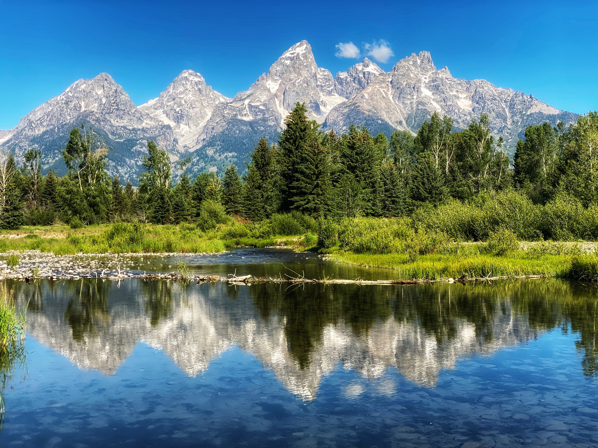
Explore Travel Shop on Expedia →The Teton Range is Wyoming’s most famous and most photographed mountain range, containing Grand Teton (13,775ft) plus Mount Moran (12,605ft), Static Peak (11,303ft), Buck Mountain, and the Cathedral Group of dramatic alpine rock peaks. Generally, the range extends approximately 40 miles north-south through Grand Teton National Park and is accessible from Jackson, Wyoming as the primary gateway town. Specifically, the Teton Range is geologically distinct as one of the youngest ranges in the Rocky Mountains — uplifted along the Teton Fault as recently as 10 million years ago, creating the dramatic vertical relief from valley floor (6,400ft at Jackson Hole) to summit (13,775ft at Grand Teton) — over 7,000 feet of vertical relief in just a few miles. Notably, the Tetons demand technical climbing skills on virtually all serious summit objectives: Grand Teton via Owen-Spalding (5.4 minimum), Mount Moran via the CMC Route (5.5 technical alpine rock), and most other Cathedral Group peaks via technical routes. Static Peak and Table Mountain (11,106ft) offer accessible non-technical hiking summits for climbers without rock skills. Exum Mountain Guides and Jackson Hole Mountain Guides hold long-standing concessionaire status with the National Park Service.
The Wind River Range is Wyoming’s largest and most remote mountain range, containing Gannett Peak (13,809ft, Wyoming’s highest summit) plus 35+ other peaks above 13,000 feet — making it Wyoming’s most concentrated 13er region. Generally, the range extends approximately 100 miles through west-central Wyoming, with Pinedale on the west and Lander on the east as the primary gateway towns. Specifically, the Wind River 13ers include Fremont Peak (13,750ft, second-highest), Mount Warren (13,720ft), Mount Helen (13,620ft), Mount Sacagawea (13,569ft), Mount Woodrow Wilson (13,502ft), Wind River Peak (13,192ft in the southern range), plus dozens of other peaks named for explorers, native leaders, and natural features. Notably, the Wind River Range demands multi-day backpacking commitment that most state-level climbing destinations don’t require — Gannett Peak’s standard route from Trail Lake Trailhead via Glacier Trail is approximately 40+ miles round-trip, typically completed as a 4-day backpacking trip with the summit attempt on day 3 from a base camp at Titcomb Basin or Dinwoody Glacier. The Wind River also contains the famous Cirque of the Towers — a dramatic granite amphitheater with classic rock climbs including Pingora, Wolf’s Head, and Warbonnet Peak.
The Bighorn Mountains in north-central Wyoming contain Cloud Peak (13,167ft, the range’s highest summit) plus Black Tooth Mountain (13,005ft), Bomber Mountain (12,840ft), Hallelujah Peak, and approximately 15 other named peaks above 12,000 feet. Generally, the range extends approximately 200 miles north-south between Sheridan and Buffalo on the east and the Bighorn Basin on the west, providing some of Wyoming’s most accessible hiking-oriented alpine peaks. Specifically, Cloud Peak via the West Tensleep Trailhead approach is approximately 22 miles round-trip, typically completed as a 2-3 day backpacking trip with the summit attempt as a Class 2 hike from Mistymoon Lake base camp — significantly more accessible than the Wind River Range’s premier peaks but still requiring multi-day commitment. Notably, the Cloud Peak Wilderness Area encompasses 189,000 acres and contains dozens of alpine lakes, making the range a popular destination for combined fishing and climbing trips. The Bighorns offer Wyoming’s best mountain experience for climbers without technical rock skills or extensive backpacking experience.
The Absaroka Range extends from northwest Wyoming into southwestern Montana, with the Wyoming portion bordering Yellowstone National Park to the east. Generally, the range contains Francs Peak (13,153ft, the highest summit in Wyoming’s portion of the Absarokas) plus Wapiti Peak, Carter Mountain, and dozens of other 12,000-13,000ft peaks. Specifically, the Absarokas are volcanic in origin — formed by extensive volcanic activity approximately 50 million years ago, creating the dramatic eroded peaks and colorful mineralized rock that characterize the range. Notably, the Absarokas receive less climbing traffic than the Tetons or Wind Rivers due to fewer “must-climb” iconic summits and more remote access via Cody, Wyoming as the gateway town. However, the range offers excellent backcountry alpine hiking and serves as the eastern boundary of greater Yellowstone — climbers and hikers attempting peaks here often combine the experience with Yellowstone National Park visits. The Absarokas also contain significant grizzly bear and wolf populations, requiring bear-aware backcountry practices.
The Black Hills extend from northeast Wyoming into western South Dakota, with the Wyoming portion containing the famous Devils Tower (5,114ft) plus various other granite domes and rock formations. Generally, the Wyoming Black Hills are characterized not by hiking-oriented summit objectives but by technical rock climbing — Devils Tower is one of America’s premier trad climbing destinations with 220+ documented routes ranging from 5.7 to 5.13+, drawing climbers worldwide. Specifically, Devils Tower itself rises only 867 feet above its base (5,114ft total elevation), but the dramatic vertical columns of phonolite porphyry create one of the world’s most distinctive climbing experiences — the standard Durrance Route (5.7) has been climbed by thousands annually since being first established in 1938. Notably, Devils Tower holds deep cultural significance for several Native American tribes including the Lakota, Cheyenne, Crow, and Arapaho, and is subject to an annual June climbing closure (voluntary) to respect indigenous ceremonies. The Tower is also famous worldwide as the climactic setting of Steven Spielberg’s “Close Encounters of the Third Kind” (1977) and was the first U.S. National Monument, established by Theodore Roosevelt in 1906.
The 10 Best Mountains to Climb in Wyoming
The 10 mountains below represent the best climbing in Wyoming across all five ranges and four difficulty levels. Generally, climbers should match peak selection to experience — Static Peak is an accessible Teton summit while Gannett Peak demands serious multi-day backpacking expertise and Grand Teton demands actual rock climbing skills. Specifically, the rankings consider summit prestige, route quality, range representation, and overall climbing significance within Wyoming mountaineering culture.
Gannett Peak is Wyoming’s highest summit and one of the most committing state highpoint objectives in the contiguous USA. Generally, the standard route from Trail Lake Trailhead via the Glacier Trail to Dinwoody Glacier is approximately 40+ miles round-trip with 7,000+ feet of total elevation gain — typically completed as a 4-day backpacking trip with the summit attempt on day 3 from a base camp at Dinwoody Glacier or Titcomb Basin. Specifically, the climb involves Class 3 scrambling on the upper mountain plus crossing the Gooseneck Glacier with crampons and ice axe — making it the only Wyoming peak that requires glacier travel skills for the standard route. Notably, despite being Wyoming’s highest peak, Gannett Peak is far less famous than Grand Teton — most people incorrectly assume Grand Teton holds the title due to its iconic profile and tourism prominence. The peak honors Henry Gannett, the “Father of American Map Making” and the chief geographer of the USGS who advocated for the creation of the National Park Service.
Grand Teton is Wyoming’s most famous peak and one of the most iconic alpine rock summits in North America. Generally, the standard Owen-Spalding route is rated 5.4 (Yosemite Decimal System) with Grade II commitment — but the actual climb involves the Belly Roll, the Crawl, the Double Chimney, and a rappel descent above 13,000 feet, making it significantly more committing than the 5.4 grade suggests. Specifically, most climbers attempt Grand Teton as a 2-day climb with overnight camp at the Lower Saddle (11,650ft) or Moraine Camp, requiring rope, harness, helmet, technical climbing gear, and alpine rock climbing experience. Notably, despite Grand Teton being Wyoming’s second-highest peak (lower than Gannett at 13,809ft), it’s universally considered Wyoming’s most demanding standard objective due to sustained technical rock climbing on every route to the summit. The Upper Exum Ridge (5.5) and Direct Exum (5.7) offer more sustained alternatives. Exum Mountain Guides and Jackson Hole Mountain Guides offer the established guided ascent programs with NPS concessionaire status.
Fremont Peak is the second-highest peak in the Wind River Range and a popular Gannett Peak alternative for climbers wanting a high Wyoming summit without the full Gannett commitment. Generally, the standard route from the Elkhart Park Trailhead via Titcomb Basin is approximately 24 miles round-trip with 5,500 feet of elevation gain — typically completed as a 3-day backpacking trip. Specifically, the route involves Class 3 scrambling on the upper mountain but doesn’t require glacier travel — making it more accessible than Gannett Peak for climbers without crampons-and-ice-axe experience. Notably, Fremont Peak is named after John C. Frémont, the 19th-century American explorer and military officer who led an 1842 expedition to the Wind River Range. Fremont may have climbed the peak in 1842 (making him one of the first non-indigenous people to summit a Wyoming 13er), though the historical record is contested. Many Wind River climbers combine Fremont with neighboring 13ers as multi-day objectives from Titcomb Basin.
Cloud Peak is the highest summit in the Bighorn Mountains and Wyoming’s most accessible high-altitude objective for climbers without technical skills. Generally, the standard route from the West Tensleep Trailhead is approximately 22 miles round-trip with 4,200 feet of elevation gain — typically completed as a 2-3 day backpacking trip with summit attempts from a base camp at Mistymoon Lake. Specifically, the summit climb itself is Class 2 hiking and scrambling on talus and broken rock, requiring no technical climbing skills beyond solid hiking ability and altitude tolerance. Notably, Cloud Peak Wilderness encompasses 189,000 acres of the Bighorn National Forest and contains over 100 named alpine lakes — making the area a popular destination for combined fishing and climbing trips. The peak gets its name from the persistent afternoon cloud cap that forms around the summit during summer thunderstorm season, making the standard rule of early summit attempts especially important on Cloud Peak.
Wind River Peak is the highest summit in the southern Wind River Range and offers a more accessible Wind River 13er experience than Gannett Peak or Fremont Peak. Generally, the standard route from the Worthen Meadow Reservoir Trailhead via Stough Creek Basin is approximately 16 miles round-trip with 4,200 feet of elevation gain — typically completed as a 2-day backpacking trip from Lander. Specifically, the route involves Class 2-3 scrambling on the upper mountain with some routefinding required on the broken summit ridge. Notably, the southern Wind River Range receives significantly less traffic than the Titcomb Basin and Glacier Trail approaches to Gannett and Fremont Peaks, making Wind River Peak an excellent option for climbers wanting a Wind River 13er experience with fewer crowds and easier logistics from Lander rather than Pinedale.
Francs Peak is the highest summit in Wyoming’s portion of the Absaroka Range and one of the most accessible 13,000ft+ Wyoming peaks for climbers wanting a less technical objective. Generally, the standard route is approximately 16 miles round-trip with 4,100 feet of elevation gain — typically completed as an overnight backpacking trip from the Cody area trailheads in Shoshone National Forest. Specifically, the route involves Class 2 hiking on broad ridges with no technical climbing required — making Francs Peak accessible to fit hikers with multi-day backpacking experience. Notably, the Absaroka Range contains significant grizzly bear populations including the Greater Yellowstone Ecosystem’s primary northern habitat — climbers must use proper bear-aware backcountry practices including bear spray, food storage in approved canisters, and travel in groups when possible. Francs Peak’s volcanic origin creates dramatic eroded ridges and colorful mineralized rock distinctive from Wyoming’s granite-and-gneiss Wind River and Teton ranges.
Mount Moran is the Teton Range’s second-most-iconic peak after Grand Teton and a serious technical climbing objective in its own right. Generally, the standard CMC Route is rated 5.5 technical alpine rock with multiple pitches of sustained climbing, plus an exposed ridge approach — typically completed as a 2-day climb with overnight camp on the lower mountain. Specifically, the iconic Skillet Glacier visible from Jackson Hole creates Mount Moran’s most distinctive feature and lures extreme skiers each spring; the glacier itself is now significantly reduced from historical extent due to climate change. Notably, Mount Moran is named after Thomas Moran, the 19th-century American landscape painter whose Yellowstone paintings influenced the creation of America’s first national park. Most climbers without prior trad climbing experience attempt Mount Moran with guide support — the route is considered more committing than Grand Teton’s Owen-Spalding despite the lower summit elevation, due to longer technical climbing and more complex routefinding.
Black Tooth Mountain is the second-highest summit in the Bighorn Mountains and a more technical alternative to nearby Cloud Peak. Generally, the standard route via the Mistymoon Lake approach involves Class 3 scrambling on the final summit pyramid — significantly harder than Cloud Peak’s Class 2 hike despite the modest elevation difference. Specifically, the peak’s distinctive dark, jagged summit profile (which inspired the name) requires careful routefinding on the upper mountain with some loose rock and exposure. Notably, Black Tooth typically receives less climbing traffic than Cloud Peak due to the technical difficulty difference — Cloud Peak’s Class 2 hiking route attracts most Bighorn climbers, while Black Tooth’s Class 3 character filters for more experienced climbers. The peak is often combined with Cloud Peak as a two-summit objective from a base camp at Mistymoon Lake.
Devils Tower is one of America’s most iconic and most famous climbing destinations — a dramatic 867-foot vertical monolith of phonolite porphyry rising above the surrounding Black Hills landscape in northeast Wyoming. Generally, the standard Durrance Route (5.7) was first established in 1938 and remains the most popular line to the summit — typically completed as a single-day climb with rappels for the descent. Specifically, Devils Tower features more than 220 documented climbing routes ranging from 5.7 to 5.13+, drawing trad climbers worldwide for the distinctive hexagonal column climbing on solid basalt. Notably, Devils Tower was America’s first National Monument, established by Theodore Roosevelt in 1906, and holds deep cultural significance for several Native American tribes including the Lakota, Cheyenne, Crow, Kiowa, and Arapaho — the National Park Service implements an annual June voluntary climbing closure to respect indigenous ceremonies and traditional uses. The Tower is also globally famous as the climactic setting of Steven Spielberg’s “Close Encounters of the Third Kind” (1977), introducing the formation to international audiences.
Static Peak is the most accessible non-technical Teton Range summit and an excellent option for climbers wanting Teton scenery without the rock climbing demands of Grand Teton or Mount Moran. Generally, the standard route via Death Canyon Trailhead is approximately 16 miles round-trip with 4,800 feet of elevation gain — typically completed as a strong day hike with summit Class 2 scrambling. Specifically, Static Peak crosses Static Peak Divide at 10,790 feet before the final ridge climb to the summit — the entire route is hiking-and-scrambling without any rock climbing required. Notably, Static Peak offers spectacular views of Grand Teton, Mount Moran, and the entire Teton Range main crest, making it an excellent acclimatization option for climbers planning Grand Teton attempts later in the same trip. The peak’s name reflects the dramatic lightning activity that frequently occurs at this elevation in the Tetons — climbers should follow strict afternoon weather discipline and aim for early-morning summits in July-August thunderstorm season.
Quick Comparison Table
| # | Peak | Elevation | Range | Distance | Difficulty |
|---|---|---|---|---|---|
| 1 | Gannett Peak | 13,809ft | Wind River | 40+ mi RT | Class 3-4 + glacier |
| 2 | Grand Teton | 13,775ft | Teton | 13 mi RT | 5.4 minimum (rock) |
| 3 | Fremont Peak | 13,750ft | Wind River | 24 mi RT | Class 3 |
| 4 | Cloud Peak | 13,167ft | Bighorn | 22 mi RT | Class 2 |
| 5 | Wind River Peak | 13,192ft | Wind River | 16 mi RT | Class 2-3 |
| 6 | Francs Peak | 13,153ft | Absaroka | 16 mi RT | Class 2 |
| 7 | Mount Moran | 12,605ft | Teton | 12 mi RT | 5.5 technical |
| 8 | Black Tooth Mtn | 13,005ft | Bighorn | 22 mi RT | Class 3 |
| 9 | Devils Tower | 5,114ft | Black Hills | Short | 5.7+ trad |
| 10 | Static Peak | 11,303ft | Teton | 16 mi RT | Class 2 |
Want the deepest Grand Teton coverage? See our dedicated Grand Teton Complete Climbing Guide for the full mountain page plus 7 specialized child pages covering routes, permits, weather, gear, difficulty, acclimatization, and guide companies.
How to Choose Your First Wyoming Mountain
Choosing the right Wyoming mountain combines honest experience assessment, range preference, technical commitment recognition, and seasonal planning. Generally, climbers should follow the 4-step protocol below rather than picking peaks based on tourism prominence (Grand Teton is the famous one but it’s also the technical one). Specifically, the protocol prevents the most common Wyoming mountain mistakes: underestimating Grand Teton as a hike, attempting Gannett Peak without backpacking experience, and ignoring Wyoming’s shorter climbing season.
The 4-Step Protocol for Choosing Your First Wyoming Mountain
- Identify your honest experience level. Beginners: Static Peak (Tetons, 11,303ft, Class 2 hike), Table Mountain (Tetons, 11,106ft), or Bomber Mountain (Bighorns, 12,840ft, Class 2). Intermediate hikers: Cloud Peak (13,167ft, 22 mi RT 2-3 days, Class 2), Francs Peak (13,153ft, Class 2). Advanced scramblers and backpackers: Gannett Peak (13,809ft, 40+ mi RT 4-day, Class 3-4 with glacier travel), Fremont Peak (13,750ft, Class 3), Wind River Peak (13,192ft, Class 2-3). Expert technical climbers: Grand Teton (13,775ft, 5.4 minimum rock), Mount Moran (12,605ft, 5.5 alpine rock), Devils Tower (5,114ft, 5.7+ trad climbing).
- Choose your range based on travel base. Teton Range — accessible from Jackson, contains Grand Teton and Mount Moran (technical objectives) plus Static Peak (accessible). Wind River Range — most remote, largest range, accessible from Pinedale (west) or Lander (east), requires multi-day backpacking for all major summits including Gannett and Fremont. Bighorn Mountains — accessible from Sheridan or Buffalo, best for non-technical climbers wanting high-altitude experience without technical commitment. Absaroka Range — accessible from Cody, less crowded, requires bear-aware backcountry practices in greater Yellowstone ecosystem. Black Hills — accessible from Crook County for Devils Tower, exclusively technical rock climbing rather than hiking summits.
- Understand Wyoming’s technical character. Wyoming has zero ranked 14ers and the state’s premier peaks demand technical skills that surprise climbers expecting Colorado-style accessible 14ers. Grand Teton at 13,775ft requires actual rock climbing (5.4 minimum), not hiking — the standard Owen-Spalding route involves the Belly Roll, the Crawl, double chimneys, and rappels above 13,000 feet. Gannett Peak requires glacier travel skills and crampons. Mount Moran is alpine rock with significant exposure. Devils Tower is exclusively technical rock climbing. Match your skills honestly — Wyoming’s premier peaks demand more technical competence than most state-level destinations.
- Plan around shorter season and remote access. Wyoming has a shorter climbing season than Colorado due to higher latitude and remote access. Grand Teton and Tetons: mid-June through September with prime conditions in July-August. Wind River Range: late June through September; Gannett Peak typically requires conditions in July or August for safe summit attempts. Bighorn Mountains: similar window. Wyoming requires more permits than Utah — Grand Teton National Park backcountry permits for overnight Lower Saddle camps, Bridger-Teton National Forest registration for Wind River wilderness, Devils Tower National Monument climbing registration, plus an annual June climbing closure on Devils Tower for indigenous ceremonies (voluntary but widely respected). Most Wyoming peaks require multi-day commitment due to remote trailheads.
Common Mistakes Wyoming Mountain Climbers Make
Avoid These Common Wyoming Mountain Mistakes
- Underestimating Grand Teton as a “hike” because it’s famous. Grand Teton at 13,775ft is technical rock climbing requiring 5.4 minimum skills, not a hike despite being attempted by thousands of inexperienced climbers annually. The standard Owen-Spalding route involves the Belly Roll, the Crawl, double chimneys, and a rappel descent above 13,000 feet. Most parties should hire Exum or JHMG guides unless they have prior trad climbing experience with rope, harness, anchor building, and rappelling skills.
- Confusing Grand Teton as Wyoming’s highest peak. Grand Teton (13,775ft) is Wyoming’s most famous peak but NOT its highest — Gannett Peak (13,809ft) in the remote Wind River Range holds that title by 34 feet. The fame of Grand Teton creates a persistent misconception that even some Wyoming residents share. Climbers planning state highpoint completion need Gannett Peak’s serious multi-day commitment, not just Grand Teton.
- Attempting Gannett Peak without backpacking experience. Gannett Peak’s 40+ mile round-trip distance and 4-day standard itinerary require serious backcountry backpacking competence — not just hiking fitness. The route involves multiple stream crossings, glacier travel with crampons, exposed Class 3-4 scrambling, and complete self-sufficiency in the Bridger Wilderness with no cell service. Build experience with shorter backpacking trips and lower-elevation glacier exposure first.
- Ignoring the June climbing closure on Devils Tower. The voluntary June climbing closure on Devils Tower respects sacred ceremonies of multiple Native American tribes including the Lakota, Cheyenne, Crow, Kiowa, and Arapaho. While the closure is technically voluntary, the climbing community widely respects it — climbing during the June closure invites significant social and ethical pushback. Plan Devils Tower climbs for outside the June window.
- Skipping bear-aware backcountry practices. Wyoming’s Wind River, Absaroka, and Yellowstone-adjacent ranges all contain significant grizzly bear populations. Backpackers must carry bear spray, store food in approved bear canisters or hang systems, travel in groups when possible, and make noise on the trail. Recent fatal grizzly encounters in the region underscore the seriousness of bear-aware practices.
- Treating Wyoming’s climbing season like Colorado’s. Wyoming’s higher latitude means shorter prime climbing windows than Colorado — Gannett Peak typically requires July-August conditions, while Grand Teton has a slightly longer window from mid-June through September. Snow on north aspects can persist much later than Colorado peaks of similar elevation. Plan accordingly.
- Underestimating the afternoon thunderstorm rule on Tetons. The Tetons generate intense afternoon thunderstorms throughout July-August with lightning that has killed climbers on multiple occasions. The “be off the summit by noon” rule is non-negotiable for Grand Teton and other Teton peaks — multiple Grand Teton climbing deaths each decade involve afternoon lightning strikes on exposed ridges.
- Confusing Devils Tower hiking with Devils Tower climbing. The Tower Trail is a 1.3-mile loop hike at the base of Devils Tower — popular with general National Monument visitors but not a “summit” of Devils Tower. Reaching the actual Tower summit requires technical rock climbing (5.7+ trad) with rope, gear, and proper rappel descent. The two activities are fundamentally different despite happening at the same location.
What We Don’t Know
Honest limitations of any Wyoming mountain guide
The 10 peaks featured represent a curated selection, not Wyoming’s full mountain inventory. Wyoming contains dozens of named peaks above 12,000 feet plus hundreds of named summits across the five ranges. The 10 peaks selected reflect range representation, difficulty progression, and historical/cultural significance — but the Wind River Range alone could justify a dedicated guide covering 35+ peaks above 13,000 feet. Climbers planning systematic Wyoming peakbagging should consult specialized resources like the SummitPost database, the Wyoming 13ers guide on SunlitSummit, and the Wyoming Trail Conservation Initiative.
The Wyoming highpoint question is more contested than it seems. Wyoming’s highest peak is officially Gannett Peak at 13,809 feet per USGS measurements. Some historical sources cite Gannett at 13,804 feet or other slightly varied figures. The 191-foot gap below 14,000 feet is sometimes incorrectly reported as smaller or larger — but the genuine measurement consistently places Wyoming’s highpoint just short of 14er status. Recent LiDAR surveys have refined Wyoming’s peak elevations slightly but haven’t fundamentally changed the rankings.
Conditions change. Trail closures, permit requirements, glacier conditions on Gannett Peak, and access road status (particularly for remote trailheads) all change year-over-year. Wyoming’s Wind River and Absaroka ranges receive less infrastructure investment than Colorado peaks — climbers should expect rougher access roads, less maintained trails, and reduced rescue infrastructure. Check current conditions through the Bridger-Teton National Forest, Shoshone National Forest, Bighorn National Forest, Grand Teton National Park, or Devils Tower National Monument before any specific climb.
Grizzly bear conditions and management evolve. The Greater Yellowstone Ecosystem grizzly bear population has been actively managed for decades, and recent legal status changes (delisting/relisting under the Endangered Species Act) affect management approaches. Climbers should consult current Wyoming Game and Fish Department guidance, FWS bear safety resources, and recent trip reports before backcountry travel in grizzly habitat.
The Devils Tower June closure status evolves. The voluntary June climbing closure has been in effect since 1995 but compliance levels and management approaches continue to evolve. Some climbers maintain that the closure should remain voluntary; others advocate for mandatory closure. Climbers planning June Devils Tower attempts should check current NPS guidance and respect indigenous community input regardless of the official policy status.
Wyoming Mountain FAQ
What is the highest mountain in Wyoming?
Gannett Peak (13,809 feet / 4,209 meters) is the highest mountain in Wyoming, located in the Wind River Range in the Bridger Wilderness of the Bridger-Teton National Forest. Gannett Peak is climbed via the Pole Creek and Titcomb Basin approach — a 40+ mile round-trip backpacking trip typically completed over 4 days, with the final summit push requiring Class 3-4 scrambling and crossing the Gooseneck Glacier with crampons and ice axe. Many people incorrectly assume Grand Teton is Wyoming’s highest peak because it’s far more famous — but Gannett Peak in the remote Wind River Range holds the title by 34 feet. Gannett Peak is also the highest summit of the Wind River Range and the highest peak in the contiguous USA north of Colorado.
How many 14ers are in Wyoming?
Wyoming has zero ranked 14ers — no mountains in Wyoming reach 14,000 feet in elevation. Wyoming’s highest peak is Gannett Peak at 13,809 feet, which falls approximately 191 feet short of the 14,000-foot threshold that defines a 14er. Wyoming does have many 13ers (peaks above 13,000 feet) concentrated in the Wind River Range — Gannett Peak, Grand Teton (13,775ft), Fremont Peak (13,750ft), Mount Warren (13,720ft), Mount Helen (13,620ft), Mount Sacagawea (13,569ft), Wind River Peak (13,192ft), Cloud Peak (13,167ft in the Bighorns), Francs Peak (13,153ft in the Absarokas), and many others. Only five US states have 14ers: Colorado (53 ranked), California (12), Washington (3), and Alaska (additional peaks above 14,000ft including Denali at 20,310ft).
How hard is Grand Teton to climb?
Grand Teton is a serious technical alpine rock climb requiring real rock climbing skills, not a hike. The standard Owen-Spalding route is rated 5.4 (Yosemite Decimal System) with Grade II commitment, but the actual climb involves the Belly Roll, the Crawl, the Double Chimney, and a rappel descent above 13,000 feet — significantly more committing than the 5.4 grade suggests in the alpine context. Most climbers attempt Grand Teton as a 2-day climb with overnight camp at the Lower Saddle or Moraine Camp, requiring rope, harness, helmet, technical climbing gear, and alpine rock climbing experience. Most climbers without prior trad climbing experience hire guides — Exum Mountain Guides and Jackson Hole Mountain Guides are the established services with NPS concessionaire status.
What are the main mountain ranges in Wyoming?
Wyoming has five major mountain ranges relevant to climbing. The Teton Range in northwest Wyoming contains Grand Teton (13,775ft) and Mount Moran (12,605ft) — dramatic alpine rock peaks accessible from Jackson Hole. The Wind River Range in west-central Wyoming is Wyoming’s largest range, containing Gannett Peak (state’s highest at 13,809ft) plus 35+ other peaks above 13,000 feet. The Bighorn Mountains in north-central Wyoming contain Cloud Peak (13,167ft, the range’s highest). The Absaroka Range in northwest Wyoming borders Yellowstone National Park and contains Francs Peak (13,153ft). The Black Hills in northeast Wyoming contain the famous Devils Tower (5,114ft monolith). Wyoming also has minor ranges including the Beartooth Mountains (extending into Montana), Snowy Range, and Medicine Bow Mountains.
What are the best mountains to climb in Wyoming?
The best mountains to climb in Wyoming span five ranges and all difficulty levels: Gannett Peak (13,809ft — Wyoming’s highest, multi-day backpack with glacier travel), Grand Teton (13,775ft — most famous, 5.4 technical rock minimum), Fremont Peak (13,750ft — second-highest Wind River peak), Cloud Peak (13,167ft — highest in Bighorn Mountains, Class 2 hiking), Wind River Peak (13,192ft — southern Wind River, accessible from Lander), Francs Peak (13,153ft — highest in Wyoming Absarokas, Class 2), Mount Moran (12,605ft — Teton Range technical alternative, 5.5 alpine rock), Black Tooth Mountain (13,005ft — second-highest Bighorn, Class 3), Devils Tower (5,114ft — iconic 5.7+ technical rock monolith), and Static Peak (11,303ft — accessible Teton summit, Class 2). Climbers should match peak selection to skills — Static Peak or Cloud Peak for beginners, Francs Peak or Fremont Peak as advancing objectives, and Grand Teton, Gannett Peak, or Devils Tower only with technical climbing experience or guide support.
Is Devils Tower in Wyoming?
Yes, Devils Tower is located in northeast Wyoming and is one of America’s most distinctive geological landmarks. Devils Tower rises to 5,114 feet of total elevation (867 feet of prominence above the surrounding terrain) in Devils Tower National Monument — established in 1906 as America’s first National Monument by Theodore Roosevelt. Devils Tower is an igneous intrusion composed of phonolite porphyry that’s eroded into hundreds of distinctive vertical columns ranging from 1 to 8 feet in diameter, formed approximately 50 million years ago. Devils Tower is one of America’s premier technical rock climbing destinations — the standard Durrance Route (5.7) was first climbed in 1938 and remains the most popular route, while the Tower features more than 220 documented climbing routes ranging from 5.7 to 5.13+. The Tower holds deep cultural significance for several Native American tribes and is the subject of an annual June voluntary climbing closure to respect indigenous ceremonies.
Sources and Methodology
Numbered Source References
This Wyoming mountain guide synthesizes data from federal land management authorities, USGS topographic records, and Wyoming-specific climbing community resources.
- USGS topographic and elevation data. United States Geological Survey — official source for peak elevations referenced throughout this guide, including Gannett Peak (13,809ft), Grand Teton (13,775ft), and all other Wyoming peak elevations.
- Grand Teton National Park (NPS). Official authority for Grand Teton climbing permits, route conditions, weather, and backcountry camping regulations.
- Bridger-Teton National Forest (USFS). Authority for Wind River Range wilderness access, Gannett Peak approach via Bridger Wilderness, and trail conditions for the major Wind River climbing approaches.
- Shoshone National Forest (USFS). Authority for Absaroka Range access and Francs Peak approach trails.
- Bighorn National Forest (USFS). Authority for Cloud Peak Wilderness access and Bighorn Mountains climbing trails.
- Devils Tower National Monument (NPS). Official authority for Devils Tower climbing registration, route information, and June voluntary climbing closure for indigenous ceremonies.
- SummitPost climbing database. Community-driven climbing database with detailed route information, historical context, and first-ascent records for Wyoming peaks.
- Internal Global Summit Guide research. Cross-referenced with our existing Grand Teton coverage including the main mountain page (/mountains-grand-teton-wyoming-usa/) plus 7 specialized child pages covering routes, permits, weather, gear, difficulty, acclimatization, and guide companies.
Methodology note. Quarterly review cycle — next review September 2026 (post-summer climbing season). Elevation data uses NAVD88 / NAPGD2022 standards. Wyoming peak rankings verified against multiple sources due to elevation variations between historical and current measurements.
Continue Your Wyoming Mountain Research
Wyoming Offers America’s Most Technical State-Level Climbing
Generally, Wyoming’s five ranges deliver complete mountain progression — Static Peak and Cloud Peak for non-technical climbers, Gannett Peak for advanced backpackers, Grand Teton for technical alpine rock climbers, and Devils Tower for trad climbing specialists. Specifically, despite having zero 14ers, Wyoming represents some of the most committing alpine climbing in the contiguous USA. Notably, Wyoming’s premier peaks demand technical skills beyond hiking — match your skills to the peak’s character honestly.
← Back to USA Mountain HubWas this helpful?
🏔Related peaks nearby
🧭Explore & compare
Global Summit Guide is an independent mountaineering resource founded in 2026. The team combines first-hand trekking and climbing experience with in-depth research and professional health and nutrition review to help climbers choose objectives, prepare properly, and stay safe.
Health, altitude, and nutrition content is reviewed by Taylor Ludlow (Registered Nurse) and Brigg Hoopes (Nutritionist).
What We Don't Know Yet
Mountain information changes quickly. This box explains the limits of what this page can responsibly promise.
- Weather, snowpack, avalanche risk, road access, and route conditions can change quickly and may be different on your climbing dates.
- Route conditions, trailhead access, crevasse exposure, stream crossings, and rescue access may vary from published planning guidance.
- Gear requirements can change by season, route variation, weather window, personal cold tolerance, and guide-service requirements.
- Comparisons simplify complex decisions; the better mountain depends on current conditions, skills, timing, budget, and risk tolerance.
- Visa, passport, vaccination, border, insurance, and local transportation rules may change before your trip.
Verify current conditions with official land managers, guide services, local forecasts, and current route reports before booking or climbing.
Part of this Global Summit Guide cluster
Explore the complete Pick Your Mountain guide for more context, routes, planning links, and related resources.
Mountaineering, rock and ice climbing, glacier travel, and high-altitude activity are inherently dangerous and can result in serious injury or death. The information on Global Summit Guide is provided for general informational and educational purposes only and is not a substitute for professional instruction, qualified guiding, proper equipment, or your own judgment and experience.
Route conditions, weather, snowpack, permits, regulations, and hazards change constantly and may differ from what is described here. Details may be incomplete, out of date, or contain errors. Always verify current information with local authorities, certified guides, and official sources before making any decision in the mountains.
Nothing on this site is medical, legal, or financial advice. Our fitness, acclimatization, altitude, and nutrition content is general in nature; consult a qualified physician before beginning any strenuous exercise program or exposing yourself to high altitude.
You are solely responsible for your own safety and decisions. To the fullest extent permitted by law, Global Summit Guide and its team accept no liability for any loss, injury, damage, or expense arising from use of, or reliance on, this information. By using this site you acknowledge these risks and accept these terms.
Some links on this site may be affiliate links. If you buy through them we may earn a small commission at no extra cost to you; this never affects our recommendations.
Global Summit Guide recommendation path
Next Best Mountain to Research
Use these recommendations to continue the right planning path instead of stopping on one page.
Use current permit, weather, route, and operator information before booking or climbing.