Climbing Patagonia: The World’s Most Dramatic Mountain Region
There is no other place on earth quite like Patagonia. A million square kilometers of ice, rock, and wind at the tail end of the Americas — where the Andes narrow to their southernmost reach and fracture into granite spires that look like they were designed for magazine covers. This guide covers the three climbing regions, the history, the famous peaks, the trekking alternatives, and the unique Patagonian climbing culture built around waiting for weather windows in the world’s most atmospheric mountain town.
region size
Patagonia’s tallest
Ice Field
on summit days
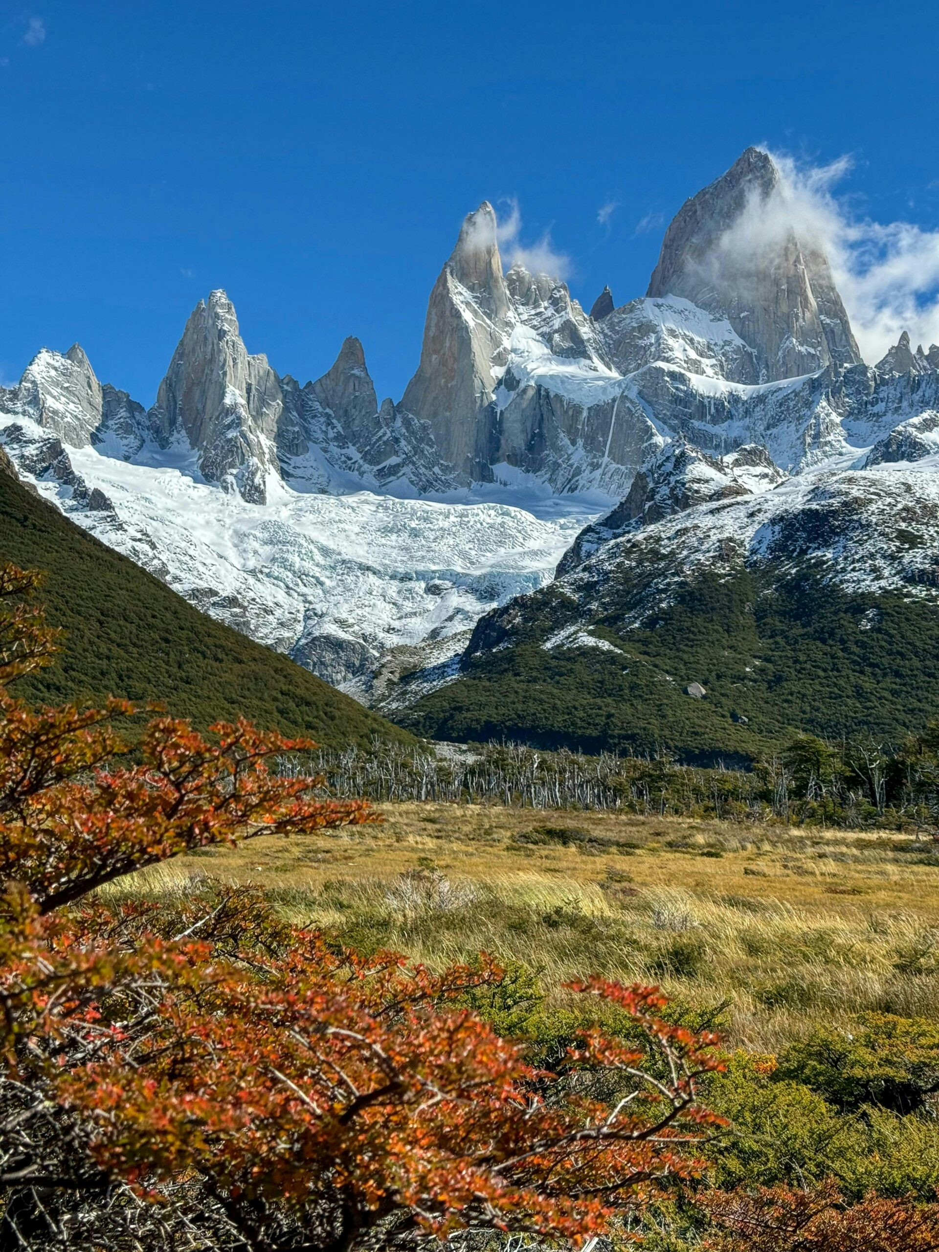
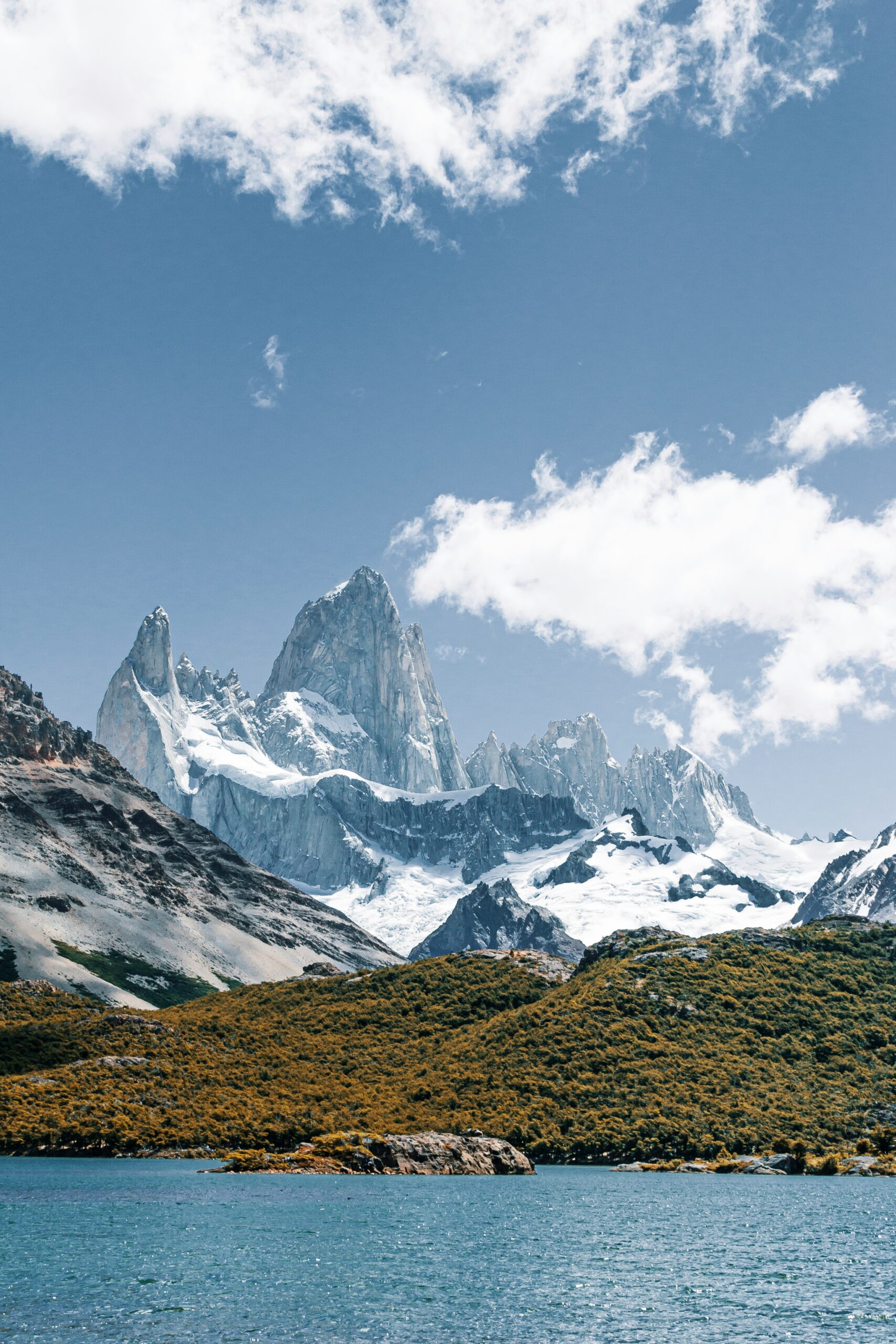
There’s a photograph every climber has seen of Cerro Fitz Roy at sunrise: a jagged black silhouette igniting in pink light against the indigo dawn, with the wild scarp of the Aguja Poincenot to its left and the needle of Cerro Torre somewhere off-frame to the right. Most climbing destinations look good in that light. Patagonia is the only one where you’ll later realize the photograph undersold what it was like to stand there. This guide covers climbing Patagonia in all its forms — the legendary granite towers of the Chaltén massif, the wind-carved walls of Torres del Paine, the Southern Patagonian Ice Field that connects them, the history that made this region the emotional capital of modern alpinism, and the small patient village where climbers wait for the weather windows that define everything.
Why Patagonia Captures Climbers Like Nowhere Else
Climbing Patagonia is not like climbing anywhere else. It’s not even close. Every major mountain region on earth is defined by its altitude, its technical difficulty, or its remoteness. Patagonia is defined by the weather — by the thousands of hours climbers spend in El Chaltén’s cafés watching forecasts, and by the fleeting 48-hour windows when the wind drops below 40 km/h and the sky clears and suddenly the entire social geography of the town shifts as climbers race to their base camps.
The mountains themselves are absurd. Fitz Roy is 3,405 meters tall, which is nothing by global standards — a third the height of Everest, barely two-thirds of Aconcagua. But it rises from its glacial apron in a way that no eight-thousander or Seven Summit does: a single monolithic granite slab nearly two vertical kilometers high, with a summit ice cap that looks like it was shellacked on by a model railroader. Cerro Torre next door is smaller still, at 3,128 meters. And yet the first confirmed ascent of Cerro Torre took until 1974 — more than two decades after Annapurna, more than 20 years after Everest. Patagonia’s peaks made fools of the best climbers of multiple generations because they weren’t high, they were impossible in ways that altitude-climbing conventions never prepared anyone for.
Reinhold Messner, the greatest high-altitude mountaineer in history, called this the most beautiful mountain area in the world. Rolando Garibotti, the definitive chronicler of the region, devoted an entire life and a magnificent 400-page guidebook (Patagonia Vertical) to describing the routes. Climbers return to El Chaltén every southern summer not because this is where you go to tick a summit — the success rate on most Patagonian objectives hovers somewhere between 1 percent and 10 percent in any given season — but because the waiting is the experience. The landscape, the town, the weather obsession, the sudden explosive joy when a window opens, the community of climbers that has built itself around this cycle for generations: this is what people mean when they say Patagonia.
What follows in this guide is the complete climbing Patagonia — the three regions, the peaks, the trekking alternatives for those not climbing, the wind, the history, and the small town where everything happens. It’s long because Patagonia is not something you can summarize in a listicle. You either understand what this place is or you don’t, and to understand it you need to spend time with it. This guide is a place to start.
Understanding Patagonia’s Geography
Patagonia is not a country. It’s a region — and a famously ill-defined one, shared between Argentina (which claims about 930,000 km² on the eastern side) and Chile (about 110,000 km² on the western Pacific coast). The Andes mountain range forms the border between the two, running north-to-south down Patagonia’s spine. The region begins roughly at the Colorado River in the north around 39° south latitude and extends to Tierra del Fuego at the tip of the continent. Total area exceeds 1.04 million square kilometers — larger than France, Germany, Italy, and the United Kingdom combined.
For climbers, almost everything happens in the southern half of Patagonia, between about 47° and 51° south latitude. This is where the Andes rise into the two most celebrated climbing massifs in the Southern Hemisphere — the Chaltén massif on the Argentine side, and the Paine Massif on the Chilean side — separated by about 350 kilometers of ice, roadless wilderness, and fjord. Getting between them requires either a long overland drive via Rio Gallegos (roughly 11 hours of bus or car travel) or an expensive flight combination. Very few climbing trips cover both in a single visit.
The geographic heart of southern Patagonia is the Southern Patagonian Ice Field (Hielo Patagónico Sur), a single continuous ice sheet covering approximately 12,363 km² — the third-largest contiguous ice mass on earth after Antarctica and Greenland. This ice field feeds famous glaciers including Perito Moreno (which calves into Lago Argentino on the Argentine side), Grey Glacier (in Torres del Paine), and Viedma and Upsala (also Argentine). Fitz Roy, Cerro Torre, and the Paine peaks all rise as rocky nunataks — islands of stone — from this ice sheet. When you stand at the base of any of these peaks, you are standing on a glacier flowing out of a much larger body of ice. The Northern Patagonian Ice Field (4,200 km²) is separated from the Southern by about 150 kilometers and contains Monte San Valentín, the highest peak in the Patagonian Andes.
Argentine Patagonia is dry, windblown steppe on the leeward side of the Andes — vast grasslands, guanacos, and far horizons. Chilean Patagonia is wet temperate rainforest on the windward side — the Westerlies dump their moisture on Chile before crossing the mountains dry. Climbers often describe the contrast as “Argentina looks like Wyoming, Chile looks like British Columbia.” The peaks sit on the Argentina-Chile border, and weather arrives from Chile and exits to Argentina. This matters because weather windows are determined by what happens over the Pacific.
The Three Climbing Regions of Patagonia
Climbing Patagonia breaks neatly into three distinct regions, each with its own character, approach, and climbing community. Almost every Patagonian climbing trip starts by picking which of these regions to visit — and understanding what you’re signing up for with that choice.
🇦🇷 Chaltén Massif
The spiritual center of modern Patagonian climbing. Fitz Roy, Cerro Torre, Poincenot, and the Aguja group rise as an interconnected skyline above the village of El Chaltén. More technical climbs than any other region; more climbing culture than anywhere else in South America. Weather-window climbing at its most refined form.
🇨🇱 Torres del Paine
The most-visited Patagonian destination — a national park built around three iconic granite spires (the Torres) and the massive Paine Massif. Far more trekkers than climbers; the famous W Circuit and O Circuit routes draw tens of thousands of hikers annually. Technical climbing on the Torres themselves is serious, committing, and less frequently attempted than Chaltén objectives.
🏔️ The Patagonian Ice Field Outliers
The peaks beyond the two main centers — Monte San Valentín (Patagonia’s highest), Cerro San Lorenzo, Cerro Murallón, the Cordillera Sarmiento, and the peaks of the Beagle Channel. These are genuinely remote objectives requiring extensive logistics — boat approaches, aerial drops, multi-week expeditions. Almost no commercial guiding exists for these peaks.
A two-week Patagonia trip realistically covers only one main region with any depth. Climbers typically choose Chaltén. Trekkers typically choose Torres del Paine. Ambitious multi-month trips occasionally combine Chaltén and Paine. The remote ice field peaks are for climbers who’ve already spent multiple seasons in the region and want something different. Plan accordingly — don’t try to do everything in ten days.
Patagonia’s Most Important Peaks and Destinations
The table below lists the 10 most significant climbing and trekking destinations covered in detail in this guide. Difficulty is expressed using the French alpine system (F easiest through ED+ hardest) where applicable, or as a trekking grade for non-climbing destinations.
| # | Peak / Destination | Elevation | Country | Region | Type | Difficulty |
|---|---|---|---|---|---|---|
| 1 | Monte San Valentín | 4,058 m / 13,314 ft | Chile | N. Ice Field | Ice/Snow | Remote PD+ |
| 2 | Cerro San Lorenzo | 3,706 m / 12,159 ft | Arg/Chi | Outlying | Mixed | Remote D |
| 3 | Cerro Fitz Roy | 3,405 m / 11,171 ft | Argentina | Chaltén Massif | Granite | ED (Franco-Arg) |
| 4 | Cerro Torre | 3,128 m / 10,262 ft | Argentina | Chaltén Massif | Ice tower | ED+ (Ragni) |
| 5 | Aguja Poincenot | 3,002 m / 9,849 ft | Argentina | Chaltén Massif | Granite | ED |
| 6 | Torre Central (Paine) | 2,884 m / 9,462 ft | Chile | Torres del Paine | Granite | ED |
| 7 | Cerro Paine Grande | 2,884 m / 9,462 ft | Chile | Torres del Paine | Mixed | D to TD |
| 8 | Aguja Guillaumet | 2,579 m / 8,461 ft | Argentina | Chaltén Massif | Granite | AD to D |
| 9 | Torres del Paine O Circuit | 130 km trek | Chile | Torres del Paine | Trekking | Moderate |
| 10 | Torres del Paine W Circuit | 80 km trek | Chile | Torres del Paine | Trekking | Moderate |
The Chaltén Massif: Fitz Roy, Cerro Torre, and the Agujas
The Chaltén massif is the beating heart of Patagonian climbing. A single connected skyline of granite spires rising above the village of El Chaltén on the Argentine side of the border, the massif holds more iconic named peaks per square kilometer than anywhere else on earth. The La Compañía (the main group — Fitz Roy, Poincenot, Saint-Exupéry, Mermoz, Guillaumet) and the Torre Group (Cerro Torre, Torre Egger, Punta Herron, Cerro Standhardt) together make up what climbers mean when they say “the Chaltén massif.” Every serious climbing trip to Patagonia begins here.
Cerro Fitz Roy
Cerro Fitz Roy is the defining mountain of Patagonia — the silhouette on the Patagonia clothing logo, the peak that appears when anyone Googles “Patagonia,” and the granite tower against which every climber eventually measures their ambition. Known locally as Chaltén (meaning “smoking mountain” in Aonikenk — the local Tehuelche people believed the clouds wreathing the summit were smoke), the mountain was first summited on February 2, 1952 by Frenchmen Lionel Terray and Guido Magnone via what is now known as the Franco-Argentine route on the southeast face. It took French alpinism’s golden generation — fresh from the first ascent of Annapurna in 1950 — to finally crack the mountain that had defeated every previous attempt.
Fitz Roy has no easy route. Every established line on the mountain involves 1,500+ meters of technical rock climbing at 5.10 grade or harder, with significant ice and mixed sections, loose blocks, and committing position. The standard Franco-Argentine (Supercouloir) route is graded ED — among the hardest standard routes on any major world mountain. The Supercanaleta (a long couloir-and-face line) and the Afanassieff route (the long west ridge) are other well-known objectives, all at similar difficulty. Alex Honnold and Tommy Caldwell’s 2014 link-up of all seven summits of the Fitz Roy massif in a single 5-day push — known as the Fitz Traverse — stands as one of the great modern alpine achievements.
Summit success rates on Fitz Roy are low even among elite climbers — estimates suggest somewhere between 5% and 15% of attempts reach the top in any given season, entirely weather-dependent. Most climbers who travel to attempt Fitz Roy spend 3-5 weeks in El Chaltén waiting for a window, often never climbing. The experience is its own reward: the daily cycle of forecasts, the base camp at Paso Superior, the granite slabs of the Orsini Towers below, the feeling of being in the middle of a landscape that nothing in the Northern Hemisphere prepares you for.
Full Fitz Roy climb guide →Cerro Torre
If Fitz Roy is the soul of Patagonia, Cerro Torre is its ghost story. A slender 3,128-meter granite spike capped by a terrifying mushroom of rime ice, the mountain looms from the Chaltén skyline as what many climbers consider the most impossible-looking mountain on earth. Italian climber Cesare Maestri claimed the first ascent in 1959 with Toni Egger (who died on the descent) — a claim now widely regarded as fabricated. In 1970, Maestri returned with a gasoline-powered compressor and drilled his way up the southeast ridge, placing 400+ bolts in what was later called the Compressor Route — an act many alpinists considered desecration. The first widely accepted “fair means” ascent came on January 13, 1974 by Italian Casimiro Ferrari, Daniele Chiappa, Mario Conti, and Pino Negri via the west face — more than 22 years after Fitz Roy was first climbed.
Cerro Torre’s standard modern route is the Ragni Route on the west face — Ferrari’s original line, named for the Italian climbing club Ragni di Lecco. Graded ED+, the route is entirely a technical ice climb: steep snow and ice runnels up the west face, a crux vertical ice column near the summit, and the final mushroom — a rime ice formation so unstable it literally changes shape from season to season. Verifying a Cerro Torre summit is itself an ongoing debate among climbers; the summit mushroom has been reported at dramatically different heights by different parties.
In January 2012, American climbers Hayden Kennedy and Jason Kruk made a notable ascent of Cerro Torre’s southeast ridge using “fair means” — no bolted aid. On their descent, they removed 125 of Maestri’s original compressor bolts, ending that line’s existence as a viable modern route and returning the mountain to something closer to its original character. The decision was controversial but celebrated by the broader climbing community. Cerro Torre remains one of the most coveted alpine objectives on earth, and one of the most defeating — most parties who attempt it leave without summiting.
Full Cerro Torre climb guide →Aguja Poincenot
Aguja Poincenot is Fitz Roy’s next-door neighbor — a slender granite obelisk rising just south of the main peak, named for Jacques Poincenot, a French climber who drowned in 1952 while attempting the first ascent of Fitz Roy with Terray and Magnone. Poincenot was first summited on February 2, 1962 by Argentines Carlos Comesaña and Clemente Fonrouge via what is now the standard Whillans-Cochrane route on the east face. For climbers seeking a major Patagonian summit that is genuinely attainable rather than aspirational, Poincenot is often cited as the finest objective in the massif.
The standard Whillans route is graded ED with sustained rock climbing at 5.10 and ice sections in the upper pitches. Most parties approach from Paso Superior base camp and complete the climb as a long committing day push during a weather window. Poincenot’s appeal for strong climbers is that it offers the full Patagonian experience — the granite, the exposure, the position in the center of the massif — at a difficulty that allows more parties to actually summit than the harder lines on Fitz Roy or Cerro Torre. Summit success rates here are meaningfully higher, though still weather-dependent.
Poincenot is often combined with nearby peaks as part of the celebrated Fitz Traverse — the linkup of all seven Fitz Roy massif summits first completed by Alex Honnold and Tommy Caldwell in 2014. The seven summits of the traverse, in order, are: Aguja Guillaumet, Aguja Mermoz, Cerro Fitz Roy, Aguja Poincenot, Aguja Rafael Juárez, Aguja Saint-Exupéry, and Aguja de l’S. For climbers working through these peaks individually rather than as a traverse, Poincenot is usually the third objective after Guillaumet and before the bigger peaks — a natural progression within a season-long trip.
The Aguja Group: Guillaumet, Mermoz, Saint-Exupéry
The northern peaks of the Chaltén massif — Aguja Guillaumet (2,579m), Aguja Mermoz (2,750m), and Aguja Saint-Exupéry (2,558m) — were named by French climbers for early Aeropostale aviators who flew mail routes over Patagonia in the 1920s: Henri Guillaumet, Jean Mermoz, and Antoine de Saint-Exupéry (later famous as the author of The Little Prince). These peaks offer the most accessible routes in the Chaltén massif and serve as essential “starter peaks” for climbers visiting the region for the first time.
Aguja Guillaumet is widely considered the easiest meaningful summit in the massif — its Amy-Vidailhet route on the northwest face is graded AD to D and involves moderate rock climbing with some snow and ice. Guillaumet’s proximity to El Chaltén and the relatively short approach to its base (about 3-4 hours from the Río Eléctrico trailhead) make it a popular first-attempt peak. Many climbers use Guillaumet as a “calibration climb” — a way to understand Patagonian rock, weather windows, and base camp life before attempting harder objectives. Success rates on Guillaumet are meaningfully higher than on the bigger peaks.
Aguja Mermoz and Aguja Saint-Exupéry are more serious — both offer technical rock routes at the D to TD grade that require sustained 5.10 climbing, strong mixed skills, and real route-finding. Both are sometimes attempted on the same trip from the same base camp, and both are popular “second objectives” for climbers who have already summited Guillaumet and are working up toward Poincenot or Fitz Roy. The approach to all three peaks shares the same valley system — the Piedras Blancas and Piedra del Fraile area northwest of El Chaltén — making multi-peak trips logistically efficient.
Torres del Paine: Chile’s Crown Jewel
If the Chaltén massif is where climbers go, Torres del Paine is where everyone else goes. The Chilean national park — Parque Nacional Torres del Paine, established in 1959 and named a UNESCO Biosphere Reserve in 1978 — is the single most-visited destination in Patagonia, with roughly 300,000 annual visitors drawn by the park’s three iconic granite towers, the massive Paine Massif backdrop, and two of the most celebrated multi-day trekking routes on earth: the W Circuit and the O Circuit. For every serious climber attempting the technical peaks of the Paine massif, there are 500 trekkers moving through the valleys between them.
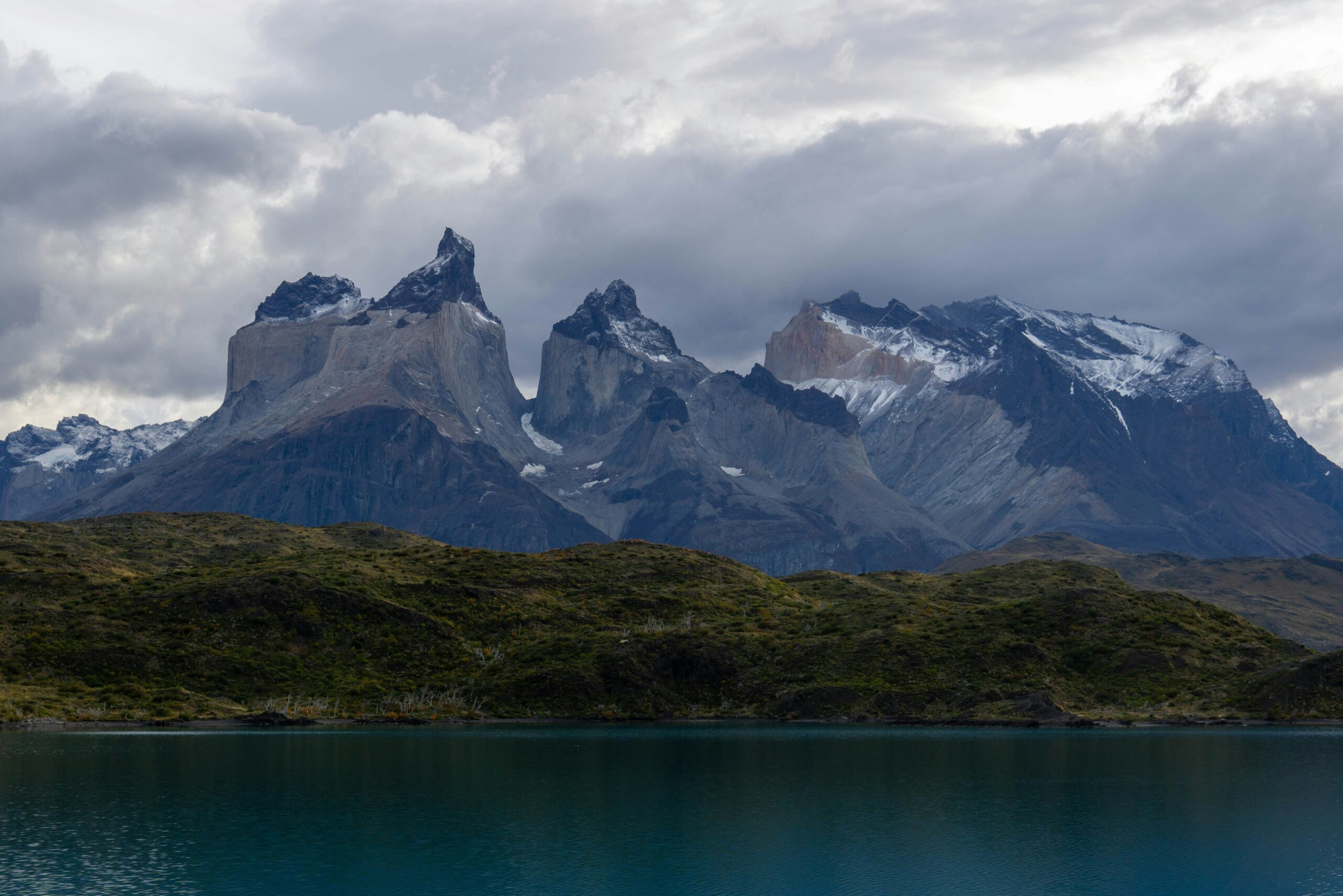
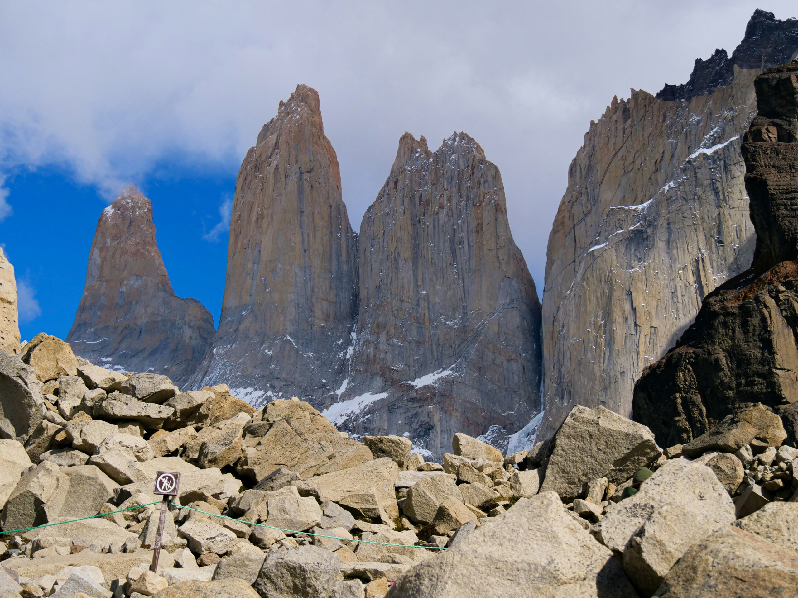
The park’s defining feature is the Paine Massif — a compact concentration of peaks rising from the southern Patagonian steppe, crowned by three vertical granite towers (las Torres) whose monolithic faces soar 1,200 to 1,500 meters directly above the valley floor. The three towers — Torre Sur (2,850m), Torre Central (2,884m), and Torre Norte (2,248m) — are unnamed in local Indigenous language but have become the visual symbol of southern Chile. Behind them rise Paine Grande (the massif’s highest point), Cerro Paine Chico, the Cuernos del Paine (the striking black-topped “Horns”), and Cerro Almirante Nieto.
Climbing the Paine Towers
The Torres themselves are serious technical objectives comparable in difficulty to Fitz Roy — but less frequently climbed because the park’s bureaucracy is more complex, the approaches longer, and the weather windows (while generally more stable than Chaltén) harder to predict from a commercial base. Torre Central‘s standard route via the south face is graded ED with sustained granite climbing. Torre Sur was first climbed in 1963 and remains technically demanding. Torre Norte is the shortest and moderately easier, though still a serious objective. Climbing here requires coordination with CONAF (Chile’s national parks service) and accepting longer approach commitments than Chaltén offers.
For most visitors, Torres del Paine is a trekking destination rather than a climbing one — and the two famous multi-day routes are as iconic as the peaks themselves.
W Circuit vs O Circuit: Choosing Your Torres del Paine Trek
The W Circuit
The W Circuit is the iconic Torres del Paine experience — named for the W-shape the route traces across the park’s three main valleys. It hits all the highlights: the Base of the Towers viewpoint (the classic sunrise photograph spot), the French Valley below the Cuernos, and the Grey Glacier terminus at the edge of the Southern Patagonian Ice Field.
The three arms:
- Eastern arm: Base de las Torres day hike (the payoff sunrise)
- Central arm: French Valley and Cuernos viewpoints
- Western arm: Grey Glacier and Paine Grande base
The W is the right choice for visitors with 4-6 days who want the essential Torres del Paine experience. Campsites and refugios require advance reservations booked 6+ months in advance for summer dates. Starting from Hotel Las Torres on the east or from Paine Grande Lodge on the west (via catamaran from Pudeto) are both viable; east-to-west is slightly more common.
The O Circuit
The O Circuit encompasses the entire Paine Massif — the W plus the backcountry northern half. Adding about 50 kilometers, three to five additional days, and the dramatic John Gardner Pass crossing (at 1,200m, the O’s highest point), the O delivers the northern face views of the massif that most visitors never see. The northern section is significantly less trafficked than the W — some days on the backcountry segments you’ll walk 4-5 hours without seeing another trekker.
What the O adds:
- Seron and Dickson campsites (day 2-3)
- Los Perros campsite below John Gardner Pass
- The John Gardner Pass crossing — spectacular ice field views
- Paso campsite on the far side, rejoining the W at Grey Glacier
The O is the serious trekker’s choice and delivers what many consider the complete Torres del Paine experience. Only hiked counterclockwise (CONAF rule). Requires strong trekking fitness, weather flexibility, and careful campsite booking. Not recommended for first-time Patagonian trekkers with less than 4 days of previous multi-day experience.
Torres del Paine’s campsite system is operated by two private concessionaires (Vertice and Fantastico Sur) plus CONAF (the national parks service). Campsites fill completely for summer dates 6-12 months in advance. Booking strategy: open reservations the moment they become available (typically July-August for the following summer) and book your campsites in sequence along your intended route. Park entrance is approximately $35-50 USD depending on season. Detailed trekking logistics, day-by-day route descriptions, and packing lists are covered in our full trekking guide.
→ Read our complete Torres del Paine trekking guide for day-by-day itineraries, campsite details, gear lists, and pre-trip logistics for both the W and O Circuits.
Beyond Chaltén and Paine: The Remote Patagonian Peaks
For climbers who have already visited the main Patagonian centers — or who specifically want away from the established circuits — the outlying peaks of Patagonia offer some of the most genuinely remote climbing on earth. These peaks see a fraction of the attention that Fitz Roy and the Torres receive, require significantly more complex logistics, and reward experienced expedition climbers with solitude unavailable elsewhere in the region.
Monte San Valentín (4,058m / 13,314 ft) is the highest peak in all of Patagonia — despite most people never having heard of it. Rising from the Northern Patagonian Ice Field near Laguna San Rafael in Chilean Aysén Province, San Valentín is a challenging expedition objective primarily due to remoteness rather than technical difficulty. The standard approach involves a boat journey and multi-day ice field traverse simply to reach base camp. First climbed in 1952 by a German-Chilean team, the peak sees only a handful of summits per year.
Cerro San Lorenzo (3,706m) straddles the Argentina-Chile border near the southern end of the Northern Patagonian Ice Field. Taller than Fitz Roy, more technical than San Valentín, and significantly more remote than either Chaltén or Paine, San Lorenzo represents the “hidden Patagonia” — an expedition-grade objective requiring weeks of logistics and commitment. Its south face is considered one of the great unclimbed lines in Patagonia.
Cerro Murallón (2,831m) is widely regarded as one of the most beautiful unclimbed big-wall objectives in Patagonia — a massive granite wall rising from the edge of the Southern Patagonian Ice Field. The east face was first climbed in 1984; other faces remain either unclimbed or rarely attempted. Murallón is for expedition climbers with extensive Patagonian experience who specifically want isolation.
Further south, the Cordillera Darwin in Chilean Tierra del Fuego offers some of the most remote mountaineering on earth — Monte Sarmiento (2,404m), Monte Darwin (2,488m), and associated peaks rising directly from the Beagle Channel. Access is by boat only, weather is even worse than mainland Patagonia, and successful summits are rare. This is the far end of committed mountaineering.
The Wind: Patagonia’s Defining Challenge
Climbers new to Patagonia expect the challenge to be technical — the granite, the ice, the altitude, the cold. They learn quickly that the challenge is the wind. Nowhere else on earth does a climbing region organize its entire culture around windspeed forecasts. Nowhere else do experienced alpinists spend three weeks in a village watching weather apps and walk away without climbing anything, counting the trip as successful because they made good decisions.
Patagonia sits directly in the path of the Roaring Forties and Furious Fifties — the belts of sustained westerly winds that circle the Southern Hemisphere between 40° and 60° south latitude. Unlike the Northern Hemisphere where continents interrupt these wind patterns, the Southern Hemisphere has almost no land between Patagonia and Antarctica to slow the air. The result is some of the most sustained wind on earth — and the Patagonian Andes stand squarely in its path. Weather systems slam into the mountains from the Pacific with extraordinary force, dump most of their moisture on the Chilean side, and emerge onto the Argentine steppe stripped of precipitation but carrying wind speeds that regularly exceed 100 km/h at mountain-top altitudes.
What “the wind” means in climbing practice: sustained winds of 80-100 km/h are normal in the Chaltén massif during the climbing season. Gusts exceeding 150 km/h occur regularly on exposed ridges and summits. Wind chill at -10°C with 100 km/h wind produces effective temperatures around -35°C. Climbing in sustained winds above about 60 km/h becomes physically dangerous — climbers can be blown off stances, ropes can become unmanageable, communication becomes impossible. Most Patagonian climbing happens in weather windows: narrow 24-72 hour periods when wind speeds drop below 40 km/h and precipitation is absent. These windows might arrive once a week, once a month, or not at all during a given trip.
Virtually every climber in El Chaltén checks meteoblue.com, windguru.cz, and meteo-chaltén.com.ar (a local forecasting site) multiple times daily. The town’s social rhythm revolves around forecasts: when a window is predicted 3-5 days out, you’ll watch the cafés fill with climbers packing gear and checking each other’s plans. When the window arrives, the town empties. When climbers return, the cafés fill again with stories and the next round of forecast-watching begins. This cycle — rest, forecast, stage, climb, rest, repeat — is the essential pattern of Patagonian climbing.
El Chaltén: The Small Town That Runs Patagonian Climbing
El Chaltén is arguably the most atmospheric climbing town in the world. Officially founded on October 12, 1985 — making it Argentina’s youngest town — El Chaltén was established hastily by the Argentine government to assert sovereignty over a disputed border region with Chile. It’s a small grid of unpaved streets in a steppe valley at 405 meters elevation, surrounded on three sides by the peaks of Los Glaciares National Park. Permanent population is approximately 2,000; summer population swells to many multiples of that as climbers and trekkers fill every hostel, cabin, and campsite in the area.
What makes El Chaltén different from other mountain towns is that almost everyone here is a climber or trekker. There’s no ski resort infrastructure, no luxury tourism, no second-home market. You will not find a shopping mall, a chain hotel, or a McDonald’s. What you’ll find is: La Senyera bakery that opens at 5 AM for pre-climb breakfasts, Patagonicus pizzeria that fills every night with climbers talking about conditions, La Cervecería brewery where post-climb celebrations happen, and a row of small climbing gear shops that stock every weather-obsessed niche product imaginable. The physical infrastructure is spartan — the main street is dusty in summer, muddy in shoulder seasons — but the cultural infrastructure is dense and knowing.
El Chaltén is within the boundaries of Los Glaciares National Park, which means the trailheads for most climbing approaches start from the edge of town. You can walk from your hostel to the trail leading to Fitz Roy base camp in 5 minutes. This extraordinary convenience — being able to step out of a coffee shop and onto the trail that leads to Laguna de los Tres and its iconic Fitz Roy view — is something no other climbing town on earth replicates. Even Chamonix requires cable cars; Zermatt requires trains. El Chaltén requires walking out the door.
For visitors who haven’t climbed, El Chaltén offers a full world of day hikes and multi-day trekking. The Laguna de los Tres hike (20 km round trip, 8-10 hours, 800m elevation gain) to the glacial lake directly beneath Fitz Roy is considered one of the most rewarding day hikes on earth. The Laguna Torre hike offers comparable scenery with Cerro Torre as the objective. Longer trekking routes include the Huemul Circuit (40 km, 4 days, more committing terrain with glacier crossings) and overnight camping options at Poincenot and D’Agostini campgrounds.
Non-Climbing Patagonia: The World Around the Climbs
Many visitors to Patagonia never climb a technical route, and for good reason: the region offers some of the most spectacular hiking, glacier viewing, and landscape tourism on earth. Even climbers spend significant portions of their trips doing non-climbing activities while waiting for weather windows — it’s part of the Patagonian experience. Here are the essential non-climbing Patagonian destinations worth knowing about.
Perito Moreno Glacier (Argentina)
The single most famous glacier in South America — and one of the only major glaciers on earth that is not retreating. Perito Moreno is a 30-kilometer-long, 5-kilometer-wide tongue of ice that calves directly into Lago Argentino in a continuous slow-motion spectacle of house-sized ice blocks falling into aqua-blue water. Viewed from extensive boardwalk systems in Los Glaciares National Park about 80 km from El Calafate, Perito Moreno is typically visited as a half-day trip from Calafate. Mini-trekking on the glacier surface is offered by several operators.
El Calafate and Lago Argentino
El Calafate is the gateway town for southern Argentine Patagonia — a small tourist-service city of 25,000 people on the southern shore of Lago Argentino. Most Patagonia visitors arrive via the El Calafate airport (FTE), spend 1-2 days seeing Perito Moreno, and then transfer 3-4 hours north to El Chaltén for climbing/trekking. El Calafate itself is pleasant but not essential beyond its role as logistical hub.
The Carretera Austral (Chile)
For travelers with time, the 1,240-kilometer Carretera Austral — Chile’s southern highway — is one of the great road journeys on earth. Winding from Puerto Montt south through fjords, rainforests, and glaciers to Villa O’Higgins at the edge of the ice field, the route is more adventure than transit. Most visitors drive segments rather than the entire route. Access to remote climbing areas like the Cochamó Valley and parts of the Northern Ice Field begins here.
Cochamó: “The Yosemite of South America”
Less famous than Chaltén or Paine, Cochamó Valley in southern Chile’s Los Lagos region has emerged over the past two decades as one of South America’s most significant big-wall rock climbing destinations. The valley’s 1,000-meter granite walls and dense old-growth forest have drawn comparisons to Yosemite. Cochamó is accessible only by a 10-km hike in — no roads reach the main climbing areas. Primary climbing season is December through March.
The History and Culture of Patagonian Climbing
Patagonia’s climbing culture has a specific lineage — a chain of figures, expeditions, and ethical debates that shaped the region from its first ascents in the 1950s through the controversies of the 2010s. Understanding this history adds depth to the climbing experience in a way that isn’t quite true of the Alps (too old to have a single lineage) or the Himalaya (too big). Here are the key figures.
Lionel Terray & Guido Magnone
French climbers, fresh from the first ascent of Annapurna, made the first ascent of Fitz Roy on February 2, 1952. Terray’s account of the climb — three days on the wall in brutal conditions — established Patagonia in the international alpine imagination. Jacques Poincenot drowned during the approach; the peak next to Fitz Roy was named for him.
Cesare Maestri & Casimiro Ferrari
Italian Cesare Maestri claimed the first ascent of Cerro Torre in 1959 — a claim now widely considered fabricated after his climbing partner Toni Egger died on the descent. In 1974, fellow Italian Casimiro Ferrari made the first confirmed ascent of Cerro Torre via the west face. The Maestri claim remains the most famous disputed first ascent in mountaineering history.
The Compressor Route controversy
Maestri returned to Cerro Torre in 1970 with a gasoline-powered air compressor and drilled more than 400 bolts up the southeast ridge. The resulting “Compressor Route” was widely condemned as desecration of the mountain. For four decades it remained a standard route despite the controversy — until 2012.
Hayden Kennedy & Jason Kruk
On January 16, 2012, American climbers Kennedy and Kruk completed the first “fair means” ascent of Cerro Torre’s southeast ridge — no bolt-aiding. On the descent, they removed 125 of Maestri’s original compressor bolts. The decision was controversial locally but celebrated by the broader alpine community as restoring the mountain’s original character.
Alex Honnold & Tommy Caldwell
The Fitz Traverse — linking all seven summits of the Fitz Roy massif in a single continuous push — was completed on February 16, 2014 by Alex Honnold and Tommy Caldwell over five days. The traverse is widely considered one of the great modern alpine achievements, combining technical rock and ice climbing with unprecedented endurance.
Rolando Garibotti
Argentine-Italian climber Rolando Garibotti has spent more than three decades documenting the climbing history and route catalog of the Chaltén massif. His 2012 guidebook Patagonia Vertical (co-authored with Dörte Pietron) remains the definitive reference for climbing the region and has shaped modern ethics and documentation practices throughout Patagonia.
Best Time to Climb Patagonia
The Patagonian climbing season runs from late October through early April, with the prime window concentrated between December and February. Understanding the seasonal weather character is essential for trip planning.
- November (early season): Long days beginning (sunset at 9-10 PM by late month). Cold but generally stable conditions. Fewer crowds in El Chaltén. Paine Circuit trekking possible but some campsites may not be fully open.
- December: Peak of early season. Days are long, El Chaltén is busy, and serious climbers begin arriving for multi-month stays. Strong wind pattern still present. Technical climbing starts to get productive as weather windows appear.
- January: Peak climbing season. Stable weather windows are most likely, but also the busiest month in El Chaltén — every campsite, hostel, and cabin books out. Torres del Paine is at peak visitation. Prices highest.
- February: Arguably the best month for serious climbers. Similar window frequency to January, fewer crowds as summer winds down, better availability. Days begin shortening but still 14+ hours of daylight.
- March: Shoulder season. Weather becomes less reliable but still possible for strong parties. Autumn colors in the Chaltén valleys are spectacular. Paine trekking is quieter and arguably more atmospheric.
- April (late season): Winter approaching. Days shortening rapidly. Many campsites close. Only experienced parties should consider April climbing.
- May-October: Winter. Patagonian winter climbing is extreme — limited daylight, severe cold, high avalanche risk. Small community of specialists attempts winter climbs; not accessible to normal climbers.
Frequently Asked Questions About Climbing Patagonia
Where is Patagonia?
Patagonia is the southernmost region of South America, split between Argentina (eastern side, about 930,000 km²) and Chile (western side, about 110,000 km²) by the Andes mountain range. The region extends from roughly 39° south latitude down to Tierra del Fuego at the continent’s southern tip. Patagonia covers more than 1.04 million square kilometers total — larger than the combined areas of France, Germany, Italy, and the UK. For climbers, the main destinations are in the southern half: the Chaltén massif (Argentine side, includes Fitz Roy and Cerro Torre), Torres del Paine National Park (Chilean side), and the outlying peaks of the Southern Patagonian Ice Field.
What is the highest peak in Patagonia?
Monte San Valentín (4,058m / 13,314 ft) in Chilean Patagonia is the highest peak in the Patagonian Andes, rising from the Northern Patagonian Ice Field. It was first climbed in 1952. Cerro San Lorenzo (3,706m) on the Argentina-Chile border is the second-highest. The Chaltén massif’s famous Fitz Roy reaches 3,405m — not the tallest in the region, but arguably the most aesthetically significant. Patagonia is not an altitude-climbing destination; the challenge is weather, wind, and technical difficulty, not elevation.
Is Fitz Roy or Cerro Torre harder?
Cerro Torre is generally considered more difficult than Fitz Roy. Cerro Torre’s standard route (the Ragni Route on the west face, an ice route) is graded ED+ with sustained technical ice climbing, while Fitz Roy’s standard Franco-Argentine route is ED with mixed rock and ice. Cerro Torre’s summit is also notoriously difficult to verify due to the mountain’s mushroom-like summit ice cap. Both peaks see extremely low summit success rates in any given season — estimated at 1-5% of attempts depending on year and weather. These are among the most technical big-mountain climbs on earth.
Can beginners climb Fitz Roy?
No — Fitz Roy has no beginner or intermediate routes. Every route on the mountain involves technical rock climbing at 5.10 or harder, significant ice and mixed terrain, and 1,500+ meters of vertical gain on the climb itself. Climbers attempting Fitz Roy should have extensive big-wall, alpine, and technical ice experience. The closest thing to a “beginner” Patagonian objective is Aguja Guillaumet (2,579m), the easiest named peak in the Chaltén massif, with established moderate routes at the AD to D grade. Most climbers visiting the Chaltén area come to trek and view Fitz Roy from Laguna de los Tres rather than climb it.
What is the best time to visit Patagonia?
The Patagonian climbing and trekking season runs from November through March (Southern Hemisphere late-spring through summer). The prime window for most climbing is December through February, with January being peak month. Climbers need “weather windows” — stable periods of 2-5 days that arrive unpredictably and require flexibility in trip planning. For trekkers in Torres del Paine or around El Chaltén, the same November-March window applies but with slightly better conditions in the shoulder months (November and March) when crowds are lighter. April and October are possible for experienced parties but weather becomes unreliable.
What is El Chaltén?
El Chaltén is the village at the base of the Chaltén massif in Argentine Patagonia, serving as the primary access point for climbing Fitz Roy, Cerro Torre, and surrounding peaks. Officially founded in 1985 as Argentina’s youngest town (to establish Argentine sovereignty in a disputed border region), El Chaltén has grown into the country’s self-declared “trekking capital” — a compact pedestrian village where virtually every shop, restaurant, and guide service caters to climbers and hikers. The town sits at 405m elevation within Los Glaciares National Park, 220 kilometers north of El Calafate. Population fluctuates from about 2,000 permanent residents to several times that during peak summer season.
W Circuit or O Circuit — which is better in Torres del Paine?
The W Circuit (4-5 days, 80km) covers the three most iconic destinations in Torres del Paine — the Base of the Towers, the French Valley, and Grey Glacier — making it the right choice for first-time visitors with limited time. The O Circuit (7-10 days, 130km) includes all of the W plus the northern backcountry section over John Gardner Pass, offering remoteness, fewer crowds, and a complete view of Paine Massif’s northern face. The O is the definitive Paine experience for serious trekkers; the W is the correct choice for most visitors. Both require advance campsite reservations 6+ months ahead for summer dates. See our Torres del Paine trekking guide for full details.
Why is wind so important in Patagonia climbing?
Patagonia sits in the path of the Roaring Forties and Furious Fifties — the zone of sustained westerly winds that circles the Southern Hemisphere between 40° and 60° latitude with almost no land to slow them down. Sustained winds of 80-100 km/h are normal; gusts exceeding 150 km/h occur regularly on exposed ridges and summits. Wind is the defining climbing challenge — more than altitude, technical difficulty, or cold. Climbers wait for “weather windows” when wind speeds drop below 40-60 km/h, often spending weeks in El Chaltén or base camps watching forecasts before finding a single climbable day. This unpredictability makes Patagonia a high-commitment, low-success-rate destination.
Do I need a permit to climb in Patagonia?
Climbing permits vary by area. Los Glaciares National Park (Argentina, covering Fitz Roy and Cerro Torre) requires climbers to register at the park ranger station in El Chaltén but charges no climbing fee. Argentine park entrance is free for the Chaltén side. Torres del Paine (Chile) charges a park entrance fee (approximately $35-$50 USD in 2026) and requires advance reservations at campsites for multi-day treks. Climbing in Torres del Paine’s technical peaks requires separate coordination with CONAF (Chile’s national parks service). Neither country has a lottery-style permit system — climbing access is administrative rather than restrictive.
What is the Patagonian Ice Field?
The Patagonian Ice Field is the largest contiguous ice mass in the Southern Hemisphere outside Antarctica, divided into Northern and Southern ice fields separated by a 150km gap. The Southern Patagonian Ice Field covers approximately 12,363 square kilometers — larger than Connecticut — and feeds numerous major glaciers including Perito Moreno, Upsala, and Viedma on the Argentine side and Grey, Tyndall, and Pío XI on the Chilean side. Fitz Roy, Cerro Torre, and the Paine Massif all rise as “islands” of rock above this ice sheet. The ice field creates Patagonia’s unique character: a land where glaciers actively calve into lakes visible from many climbing base camps.
Plan Your Patagonia Trip
For detailed planning on individual Patagonia objectives — and broader preparation for climbing in the region’s unique conditions — see the guides below.
Your Patagonia Trip, Whatever Form It Takes
Whether you’re a climber planning a month in El Chaltén, a trekker working out the logistics of the Paine O Circuit, or somewhere in between, Patagonia rewards careful planning and flexibility in equal measure. Start with our Torres del Paine trekking guide for the essential trekker’s perspective, or the Fitz Roy and Cerro Torre climb guides for technical details.