
Last updated June 8, 2026
How to Climb Iztaccíhuatl: Mexico’s Third-Highest Peak, the Arista del Sol & the Sleeping Woman Legend
Mexico’s third-highest mountain at 5,230m — the “Sleeping Woman” of Aztec legend. A 2-3 day climb from Mexico City via La Joya basecamp, ascending the Arista del Sol (Ridge of the Sun) across the volcano’s torso to El Pecho (the Breast). The classic 5,000m+ acclimatization peak for Pico de Orizaba expeditions and one of the most accessible glaciated summits in North America.
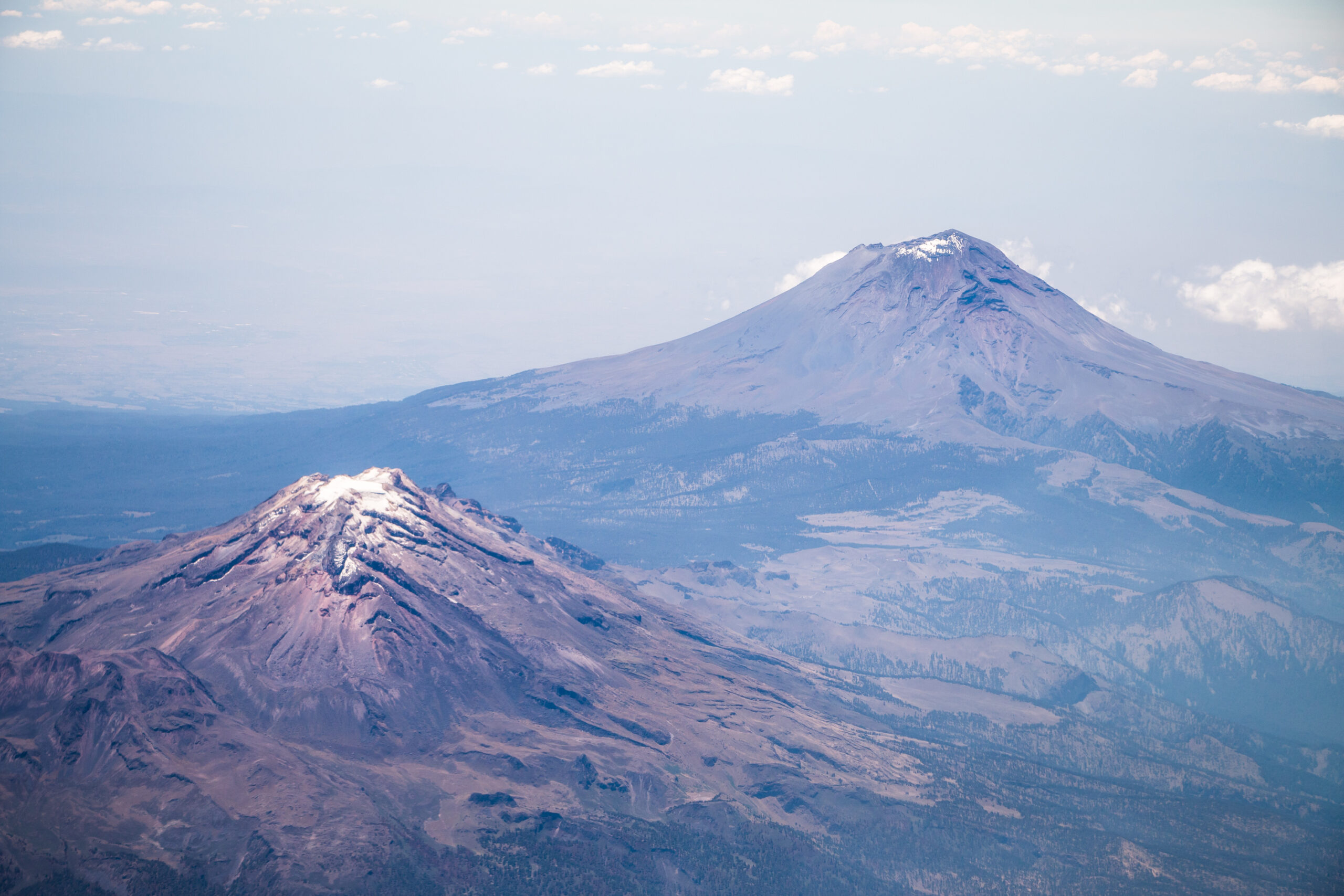
Iztaccíhuatl is Mexico’s third-highest mountain — a 5,230-meter (17,160-foot) dormant stratovolcano in the Trans-Mexican Volcanic Belt, located approximately 70 kilometers southeast of Mexico City on the boundary between México State and Puebla. Known affectionately as “Izta” by climbers and as “La Mujer Dormida” (The Sleeping Woman) by Mexicans, the peak takes its name from the Nahuatl Aztec language — “Iztaccíhuatl” means “White Woman” (from iztāc “white” + cihuātl “woman”). The mountain’s distinctive silhouette, visible from Mexico City and Puebla on clear days, resembles a woman lying on her back, with four main peaks corresponding to her body parts: La Cabeza (the Head, 5,146m), El Pecho (the Breast, 5,230m — the highest point and true summit), La Barriga (the Belly), and Los Pies (the Feet, 5,030m). According to Aztec legend — perhaps the most famous Romeo-and-Juliet tale of Mexican mythology — Iztaccíhuatl was a princess who died of grief upon receiving a false report that her warrior lover Popocatépetl had been killed in battle. When the victorious Popocatépetl returned and discovered the tragedy, he carried her body to a high place and lit a torch he vowed never to extinguish; the gods covered both lovers with snow and transformed them into the two volcanoes that face each other across the Paso de Cortés saddle today — Iztaccíhuatl the eternally sleeping Sleeping Woman, and Popocatépetl (5,426m, “Smoking Mountain” in Nahuatl) the actively erupting volcano standing eternal vigil. Iztaccíhuatl is the substantial 8th highest peak in North America, the substantial third-highest in Mexico (after Pico de Orizaba 5,636m and Popocatépetl 5,426m), and the substantial classic acclimatization peak for international climbers pursuing Pico de Orizaba expeditions. The standard climb is the Arista del Sol (Ridge of the Sun) route from La Joya trailhead (3,930m), ascending through four mountain passes (Los Portillos), past the Refugio del Grupo de los Cien at 4,725m, and across the glacier-covered summit ridge to El Pecho. Despite its 5,230m elevation, the climb is non-technical in the sense that no roped rock climbing is required — but the substantial altitude, the substantial multi-pitch summit ridge traverse, and the substantial glacier crossing demand crampons, ice axe, helmet, and substantial cardiovascular fitness. This guide covers the Arista del Sol route in complete detail, the Knees and El Pecho summit ridge, 2026 access and permit requirements via Paso de Cortés, the Aztec legend that defines the peak’s cultural identity, Popocatépetl’s volcanic activity affecting access, basecamp logistics at La Joya, and why Iztaccíhuatl remains the most popular Mexican volcano for international mountaineers building toward Pico de Orizaba and other higher Latin American objectives.
Iztaccíhuatl Location & Live Weather
Iztaccíhuatl is located in the Trans-Mexican Volcanic Belt on the boundary between México State and Puebla, approximately 70 kilometers southeast of Mexico City. The summit coordinates are 19.1789°N, 98.6417°W. Climbers approach via Amecameca (west side) or San Nicolas de los Ranchos (east side), then drive to Paso de Cortés (3,600m) for permits, continuing to the La Joya trailhead at 3,930m. International access via Mexico City International Airport (MEX) — the largest airport in Latin America — or Puebla International Airport (PBC); both have substantial connections from North American, European, and Latin American cities.
Weather data from Open-Meteo at coordinates 19.1789°N, 98.6417°W. Summit conditions at 5,230m are typically 25-30°C colder than valley readings. Mexican dry season (November-March) provides the most stable summit conditions; rainy season (May-September) brings substantial afternoon thunderstorms.
Find Hotels, Flights & Trips for the World’s Best Hiking Destinations
The Global Summit Guide Travel Shop on Expedia — curated for outdoor adventurers, mountaineers, and serious hikers. Patagonia to the Alps. Nepal to the Rockies. Curated lodging for every region we cover.
Explore Travel Shop on Expedia →Iztaccíhuatl At a Glance
| Summit elevation | 5,230 m (17,160 ft) — Mexico’s third-highest peak; sources cite 5,230-5,286m depending on survey |
|---|---|
| Local name | Iztaccíhuatl (Nahuatl Aztec, meaning “White Woman”); also spelled Ixtaccíhuatl; commonly called “La Mujer Dormida” (The Sleeping Woman) in Spanish; “Izta” by climbers |
| Location | Boundary of México State and Puebla, central Mexico; ~70 km southeast of Mexico City |
| Coordinates | 19.1789°N, 98.6417°W |
| Geographic significance | Third-highest peak in Mexico (after Pico de Orizaba 5,636m and Popocatépetl 5,426m); 8th highest in North America; prominence 1,530m; one of Mexico’s most culturally significant peaks |
| National Park | Iztaccíhuatl-Popocatépetl National Park (Parque Nacional Iztaccíhuatl-Popocatépetl) — one of Mexico’s oldest protected areas; jointly protects Iztaccíhuatl and Popocatépetl |
| Volcanic type | Dormant stratovolcano; part of Trans-Mexican Volcanic Belt; last eruption 1868 (Britannica) / Holocene era; substantial glacier retreat across recent decades |
| Sister peak | Popocatépetl (5,426m, “Smoking Mountain”) — active volcano connected by Paso de Cortés; the warrior lover of the Aztec legend |
| Anatomy peaks | La Cabeza (Head, 5,146m); El Pecho (Breast, 5,230m — true summit); La Barriga / El Vientre (Belly); Los Pies (Feet, 5,030m); Las Rodillas (Knees) on the Arista del Sol |
| First documented ascent | 1889 by James de Salis |
| Standard route | Arista del Sol (Ridge of the Sun) — from La Joya (3,930m) via four Portillos and Refugio del Grupo de los Cien (4,725m) to El Pecho summit; ~16 km RT; ~1,300m gain |
| Trailhead | La Joya (3,930m / 12,894 ft) — basecamp with tent sites; accessed via Paso de Cortés permit gate |
| Technical character | Non-technical (no roped climbing); crampons, ice axe, helmet required for summit ridge glacier |
| Standard duration | 2-3 days (Mexico City to summit and return); 8-14 hours summit day |
| Best season | November through March (Mexican dry season); December-January absolute peak conditions |
| 2026 cost range | $3-$1,000 — exceptionally affordable: 58 MXN ($3-$4) park fee; $300-$700 guided 2-day trips |
| Mandatory guide | No — independent climbing permitted; guided trips strongly recommended for international climbers |
| Popocatépetl access risk | Active volcanic activity at Popocatépetl can close gate access; green/yellow/red lamp system at Paso de Cortés indicates current status |
Why Iztaccíhuatl Is The Classic Mexican Volcano
Iztaccíhuatl occupies a distinctive position in North American mountaineering — the most accessible 5,000m+ summit on the continent, the primary acclimatization peak for Pico de Orizaba expeditions, and the centerpiece of one of Mexico’s most beloved cultural narratives.
The Pre-Pico de Orizaba Acclimatization Peak
Iztaccíhuatl is the standard acclimatization peak for international climbers pursuing Pico de Orizaba (5,636m), Mexico’s highest mountain and the third-highest peak in North America. The classic Mexican volcanoes expedition combines both peaks in a 7-10 day program: arrival in Mexico City, acclimatization day(s), 2-3 day Iztaccíhuatl climb, 1-2 rest days, then 3-4 day Pico de Orizaba climb. The sequencing provides optimal acclimatization curve — Iztaccíhuatl’s 5,230m summit provides essential high-altitude exposure for subsequent Orizaba success. International operators (Mountain Gurus, Alpine Ascents, RMI Expeditions, IMG, and Mexican-based services) structure expeditions around this Iztaccíhuatl-then-Orizaba progression, with success rates substantially higher than direct Orizaba attempts.
Glaciated Summit at Accessible Altitude
Iztaccíhuatl provides glacier crossing experience at accessible altitude and cost. The Arista del Sol summit ridge crosses the remaining glacier covering the volcano’s “torso,” requiring crampons, ice axe, and helmet across 1-2 km of glacier terrain at 4,800-5,200m altitude. The experience provides essential preparation for larger glaciated peaks — Denali, Aconcagua, Cascade volcanoes, Andean high peaks. The glacier has receded substantially across recent decades due to climate change, with current ice concentrated on the summit ridge.
The Sleeping Woman Cultural Identity
Iztaccíhuatl is the centerpiece of Mexican cultural mythology. The Aztec legend of the Sleeping Woman princess and her warrior lover Popocatépetl is taught to Mexican children, depicted in public art (the famous Jesús Helguera paintings), and referenced throughout Mexican literature and popular culture. The mountain preserves pre-Hispanic cultural identity that predates the Spanish conquest of Mexico in 1521 by centuries. Climbers approaching Iztaccíhuatl gain cultural depth unavailable on other major North American peaks — proximity to Aztec archaeological sites (Teotihuacán, Templo Mayor, Cholula), the Mexico City Anthropology Museum, colonial-era cities (Puebla, Cholula, Cuernavaca), and regional Nahuatl-speaking communities.
The honest framing. Iztaccíhuatl is the classic Mexican volcano experience — accessible altitude, glacier crossing experience, cultural depth, and affordable cost. But accessibility does not eliminate preparation needs. The 5,230m elevation demands proper acclimatization (4-7 days at altitude before summit attempt), the 8-14 hour summit days demand cardiovascular fitness, and the crampons-and-ice-axe glacier crossing demands basic mountaineering competency. The mountain rewards proper preparation and handles complacent attempts poorly.
Who Can Realistically Climb Iztaccíhuatl?
Iztaccíhuatl Is Appropriate For:
Climbers building toward Pico de Orizaba. The primary appropriate audience for Iztaccíhuatl is international climbers using it as the acclimatization peak for subsequent Pico de Orizaba attempts. The combined 7-10 day Mexican volcanoes expedition produces substantially better Orizaba success rates than direct Orizaba attempts.
Climbers with prior 4,000m+ altitude experience. Climbers with prior experience on Mount Kilimanjaro, Mount Whitney, Mont Blanc, European 4,000ers, or Andean peaks succeed well on Iztaccíhuatl. The 5,230m elevation provides a step-up from 4,000m peaks without a dramatic increase in technical complexity.
Climbers with basic mountaineering skills and crampon experience. Iztaccíhuatl requires crampon proficiency on moderate glacier terrain. Climbers with prior crampon experience (winter mountaineering courses, Mont Blanc, Cascade volcanoes, European Alps glacier travel) are well-prepared. Complete beginners can engage guided trips with pre-climb crampon instruction.
North American and European climbers seeking accessible 5,000m+ experience. Mexico City connectivity from North American cities and European capitals makes Iztaccíhuatl logistically simple. A complete 4-5 day trip including international travel is achievable for weekend or vacation climbing.
Climbers prioritizing cultural depth alongside climbing. Mexico City and the surrounding region offer extraordinary cultural richness — Aztec archaeological sites, colonial-era architecture, exceptional Mexican cuisine. An Iztaccíhuatl climb combined with cultural exploration produces a substantially richer Mexican travel experience than pure peak-bagging.
Iztaccíhuatl Is Not Appropriate For:
Sea-level climbers without acclimatization plans. The 5,230m altitude produces substantial AMS risk for unacclimatized climbers. Climbers should arrive in Mexico City (2,240m) at least 2-3 days before climb start, complete an acclimatization hike (Nevado de Toluca at 4,690m is the classic pre-Izta acclimatization), and follow gradual altitude gain.
Climbers with cardiovascular disease or uncontrolled hypertension. The 5,230m altitude produces substantial cardiac stress. Climbers with prior cardiac events, current arrhythmias, uncontrolled hypertension, or respiratory illness should consult physicians before Iztaccíhuatl attempts.
Climbers without basic mountaineering skills. Iztaccíhuatl glacier crossing requires crampon proficiency, ice axe basics, and mountain safety judgment. Complete mountaineering beginners should engage guided trips with pre-climb skills instruction, or complete a prior beginner mountaineering course.
Climbers during Popocatépetl high-activity periods. Active Popocatépetl can close the access road to La Joya. A green lamp at Paso de Cortés indicates normal access; yellow indicates warning; red prevents passage. Climbers should verify current Popo activity status before trip planning. The 2023-2025 period saw multiple Popo eruption episodes affecting access.
Iztaccíhuatl’s Role in the Latin American Peak Progression
| Stage | Peak / Experience | Elevation | Why this position |
|---|---|---|---|
| Entry | Mount Whitney (USA) or Mount Hood (USA) | 3,429-4,421m | First major peaks; moderate altitude |
| Glacier Practice | Mount Rainier (USA Cascades) | 4,392m | Glaciated climb; real crampon experience |
| First 5,000m+ | Iztaccíhuatl (Mexico) | 5,230m | Accessible 5,000m+; pre-Orizaba acclimatization |
| Mexico’s Highest | Pico de Orizaba (Mexico) | 5,636m | Mexico #1; 3rd highest in N. America |
| African Iconic | Mount Kilimanjaro (Tanzania) | 5,895m | Africa’s highest; non-technical hike |
| Andean Entry | Huayna Potosí (Bolivia) or Cotopaxi (Ecuador) | 5,897-6,088m | Accessible 6,000m+ Andean peaks |
| Andean Apex | Aconcagua (Argentina) | 6,961m | South America’s highest; multi-week expedition |
| Continental Apex | Denali (USA Alaska) | 6,190m | North America’s highest; expedition climbing |
Climbers building Latin American mountain portfolios often start with the Iztaccíhuatl-plus-Orizaba combination as their Mexican introduction, progress to Bolivian or Ecuadorian 6,000m peaks, then pursue Aconcagua or higher Andean objectives.
Iztaccíhuatl History: From Aztec Mythology to Modern Mountaineering
The Iztaccíhuatl-Popocatépetl massif was regarded as sacred by pre-Aztec peoples of central Mexico for thousands of years. Archaeological evidence includes shrine ruins found as high as 3,650m (12,000 ft) on both peaks, demonstrating religious functions for various pre-Hispanic cultures. The mountains served as geographic landmarks and spiritual centers across centuries before Aztec arrival in the Valley of Anahuac.
The Aztecs (Mexica people) founded Tenochtitlan — the capital of the Aztec Empire and predecessor of modern Mexico City — in 1325 on an island in Lake Texcoco. The new capital placed the Iztaccíhuatl-Popocatépetl peaks directly visible from the city, approximately 70 km to the southeast. The Aztecs incorporated the peaks into their cosmology, with Xiuhtecuhtli serving as the volcano deity. The peaks became central religious sites and the subject of the famous legend that would define their cultural identity for centuries.
The Aztec legend of Popocatépetl and Iztaccíhuatl emerged during the Aztec period and became the Romeo and Juliet of Mexican pre-Hispanic mythology. According to the legend, Iztaccíhuatl was the beautiful daughter of the Aztec emperor, and Popocatépetl was a brave warrior who fell deeply in love with her. The emperor agreed to allow their marriage only if Popocatépetl returned victorious from battle. Popocatépetl departed for war and triumphed, but a rival suitor falsely reported his death. Iztaccíhuatl, devastated by grief, refused to eat and fell into a fatal sleep. When Popocatépetl returned and discovered the tragedy, he carried her body to a high place outside Tenochtitlan, knelt beside her, and lit a torch he vowed never to extinguish. The gods, moved by their love, covered both lovers with snow and transformed them into mountains. Iztaccíhuatl became the Sleeping Woman; Popocatépetl became the Smoking Mountain, still actively erupting in honor of his eternal vigil. The legend was recorded by Franciscan Friar Bernardino de Sahagún in his 16th-century writings.
In 1519, Hernán Cortés and his Spanish conquistadors arrived in central Mexico and made their famous approach to Tenochtitlan via the high mountain pass between Iztaccíhuatl and Popocatépetl — subsequently named “Paso de Cortés” (Cortés Pass) in his honor. The 3,600m pass became a critical geographic landmark of the Spanish conquest. During the approach, Cortés reportedly sent a small expedition led by Diego de Ordaz to climb Popocatépetl — possibly the first European attempt on a major Mexican volcano, though the summit was likely not reached. The Spanish conquest ended the Aztec Empire by 1521 with the fall of Tenochtitlan.
Throughout the 290-year Spanish colonial period (1521-1810), the Nahuatl names Iztaccíhuatl and Popocatépetl were preserved in Spanish cartography and continued use, despite substantial Hispanicization of much regional naming. The preservation reflected the substantial cultural significance of the peaks and the integration of Nahuatl place names into Spanish-colonial Mexican identity. Colonial-era priests and explorers occasionally documented climbs and observations of the peaks.
According to Encyclopaedia Britannica documentation, Iztaccíhuatl experienced its last documented eruption in 1868, after which the volcano entered dormancy that continues to the present day. The 1868 eruption marked the transition from active to dormant volcanic status. Subsequent volcanic activity has been limited to occasional thermal anomalies and limited fumarolic activity, with no eruptions across more than 150 years. The mountain substantially differs from neighboring Popocatépetl, which has continued active eruptions throughout the 20th and 21st centuries.
The first documented ascent of Iztaccíhuatl occurred in 1889 by James de Salis, establishing the modern mountaineering era on the peak. Earlier pre-Hispanic and colonial-era summits are possible but not formally documented. The 1889 ascent established Iztaccíhuatl in modern mountaineering literature and inspired subsequent climbing activity throughout the late 19th and early 20th centuries.
Iztaccíhuatl-Popocatépetl National Park (Parque Nacional Iztaccíhuatl-Popocatépetl) was established in 1935 — one of Mexico’s oldest protected areas. The park jointly protects both peaks and the surrounding ecosystem including the Paso de Cortés saddle, alpine meadows, and pine forests of the lower slopes. The substantial protected area covers approximately 25,679 hectares, providing both conservation framework and substantial framework for organized climbing access via the modern permit system.
The mid-20th century saw substantial development of modern climbing infrastructure on Iztaccíhuatl, including the construction of the Refugio del Grupo de los Cien (a small hut at 4,725m named for the climbing group that built it) and various other shelters and route improvements. The La Joya trailhead road was developed, providing vehicle access to the 3,930m basecamp area. Mexican climbing clubs (Grupo de los Cien, Club Alpino Mexicano, and others) established documented routes and provided basic climber education for both Mexican and international climbers.
In December 1994, the neighboring Popocatépetl volcano reactivated after approximately 70 years of dormancy, beginning a sustained eruption sequence that continues to the present day. The substantial Popocatépetl activity has periodically affected Iztaccíhuatl access, with gas, ash, and eruption episodes occasionally closing the road from Paso de Cortés to La Joya. The park authorities established a green/yellow/red lamp warning system at Paso de Cortés to communicate current volcanic activity status to climbers and visitors. Major Popocatépetl eruption episodes during 2000, 2012, 2019, and 2022-2024 have variously affected Iztaccíhuatl climbing logistics.
The 2020-2026 period has seen continued growth of international climbing tourism on Iztaccíhuatl, with substantial recovery from COVID-19 disruption and increasing visitor volumes returning to pre-pandemic levels. Popocatépetl volcanic activity has continued affecting access intermittently, with multiple closure episodes during 2022-2024 requiring substantial flexibility in trip planning. The Iztaccíhuatl glacier has continued retreating due to climate change, with the substantial remaining ice now concentrated on the Arista del Sol summit ridge. The climbing community has substantially adapted to changing glacier conditions with updated equipment recommendations and route descriptions.
The Routes of Iztaccíhuatl
Iztaccíhuatl has one dominant standard route and several variations. Approximately 95% of summit attempts use the Arista del Sol (Ridge of the Sun) from La Joya trailhead.
| Route | Start | Distance (RT) | Days | Best For |
|---|---|---|---|---|
| Arista del Sol (Standard) | La Joya (3,930m) | ~16 km | 2-3 days | Standard summit route; ~95% of climbers |
| Arista del Sol via Refugio (3-day) | La Joya + Refugio (4,725m) | ~16 km | 3 days | Better acclimatization; higher success rate |
| Traverse Routes (Pies to Cabeza) | La Joya | ~20 km | 3-4 days | Experienced climbers; multi-summit traverse |
| Direct East Face | San Nicolas de los Ranchos | Variable | 3-5 days | Experienced mountaineers; less-traveled approach |
Route 1: Arista del Sol (Ridge of the Sun) Standard Route
The Arista del Sol is the standard route on Iztaccíhuatl, used by approximately 95% of all summit attempts. The route starts from La Joya trailhead at 3,930m, ascends through four mountain passes (Los Portillos), reaches the Refugio del Grupo de los Cien at 4,725m, continues up steep scree to the Knees (Las Rodillas) at approximately 5,030m, then traverses the glaciated summit ridge (the Arista del Sol — “Ridge of the Sun”) to El Pecho at 5,230m.
Section-by-section breakdown:
- La Joya to Los Portillos (3,930m-4,300m, ~1.5 km): Initial ascent over a small saddle descent and then climb. Trail is well-worn but rocky. Pre-dawn hiking with headlamps for early-start summit attempts.
- Los Portillos to Refugio del Grupo de los Cien (4,300m-4,725m, ~2 km): Substantial ascent through alpine zone. Refugio is small (sleeps approximately 20 in tight conditions) — most climbers continue past or stop briefly here.
- Refugio to The Knees / Las Rodillas (4,725m-5,030m): Steep scree slope ascent. Psychologically demanding section — substantial climbers describe this as the hardest part of the climb. Transition to crampons typically occurs at the first knee.
- The Knees to El Pecho via Arista del Sol (5,030m-5,230m, ~1.5 km): The summit ridge traverse across the glaciated “torso” of the Sleeping Woman. Crampons, ice axe, and helmet required. Substantial ridge undulates between 5,030m and 5,230m with multiple sub-summits to cross. Final push to El Pecho summit.
- El Pecho summit (5,230m): Mexico’s third-highest point. Views include Popocatépetl smoking to the south, Pico de Orizaba in the distance to the east on clear days, and Mexico City to the northwest.
Route 2: Arista del Sol via Refugio (3-Day Format)
The 3-day Arista del Sol variant adds an additional acclimatization night at the Refugio del Grupo de los Cien (4,725m), substantially improving summit success rates by providing better altitude adaptation. Typical itinerary: Day 1 La Joya to Refugio (4-5 hours, gear-laden ascent); Day 2 acclimatization day at Refugio with optional sub-peak hikes; Day 3 summit attempt and full descent to La Joya. The substantial format is particularly appropriate for climbers without prior 5,000m+ experience and for international climbers prioritizing maximum probability of summit success.
Route 3: Traverse Routes — Pies to Cabeza
The full Sleeping Woman traverse climbs all four anatomical peaks — Los Pies (the Feet, 5,030m), El Pecho (the Breast, 5,230m, the highest), La Barriga (the Belly), and La Cabeza (the Head, 5,146m) — in a multi-day traverse across the full massif. Substantial more demanding than the standard Arista del Sol route, requiring substantial route-finding, multiple camps, and additional technical sections. Appropriate for experienced mountaineers seeking a more substantial Iztaccíhuatl experience beyond the standard summit climb.
The Iztaccíhuatl Summit Day: Hour-by-Hour from La Joya
Iztaccíhuatl summit day from La Joya is the demanding portion of the standard 2-3 day climb — beginning before dawn, ascending 1,300 vertical meters to El Pecho summit, then descending back to La Joya basecamp.
Standard Iztaccíhuatl Summit Day — La Joya (3,930m) to El Pecho (5,230m) and Return
The summit day weather discipline. Iztaccíhuatl’s afternoon weather pattern requires substantial pre-dawn starts. The dry season (November-March) provides most stable conditions, but afternoon cloud build-up and occasional snow showers can develop even during peak season. Climbers above the Knees at 14:00 risk caught in deteriorating conditions on the glaciated ridge. The 02:00-03:00 La Joya departure is essential discipline that has kept Iztaccíhuatl climbing safe for decades. Climbers should monitor Mexican meteorological forecasts (SMN — Servicio Meteorológico Nacional) and Popocatépetl activity status before any attempt.
Iztaccíhuatl Costs in 2026: Park Fees, Guides, and Total Budget
Iztaccíhuatl is one of the most affordable major 5,000m+ peak climbs in the world — exceptionally low park fees, optional guide requirements, and substantial Mexican mountaineering infrastructure providing affordable services.
2026 Climbing Costs
| Service / Format | 2026 Cost | What’s Included |
|---|---|---|
| Iztaccíhuatl-Popocatépetl National Park entry | 58 MXN (~$3-$4 USD)/person | Park entrance fee; required for all climbers; paid at Paso de Cortés or Amecameca headquarters |
| Self-guided 2-day Iztaccíhuatl climb | $50-$150 total | Park fees + food + camping equipment rental if needed |
| Guided 2-day Iztaccíhuatl climb (Mexican operators) | $300-$700/person | Transport from Mexico City/Puebla, La Joya basecamp, all meals, technical equipment rental, certified guide |
| Premium guided 2-day (small group, English-speaking) | $500-$1,000/person | Higher service level, smaller group ratios, English-speaking certified guide |
| Guided 3-day Iztaccíhuatl with high camp | $500-$1,200/person | Better acclimatization itinerary with Refugio overnight |
| Mexican Volcanoes Expedition (Izta + Orizaba, 7-10 days) | $2,500-$5,000/person | Complete combined expedition with international-grade operators |
2026 Total Trip Budget
| Cost Component | 2026 Amount (USD) | Notes |
|---|---|---|
| Park entry fee | $3-$4 | 58 MXN per person; paid in cash typically |
| International flights to Mexico City (MEX) | $200-$1,200 | Variation by origin; substantial low-cost connections from North America |
| Mexico entry | $0 | No visa required for most Western nationalities (180-day tourist permit) |
| Mexico City to Amecameca transport | $30-$100 | Bus or private vehicle; 1-2 hours |
| Amecameca to La Joya transport | $50-$150 | Taxi or rental SUV (4WD recommended for rough road) |
| Mexico City hotels (2-3 nights) | $60-$300 | Substantial range from budget hostels to premium hotels |
| Meals in Mexico | $50-$200 | Affordable Mexican cuisine |
| Equipment rental (if needed) | $50-$200 | Crampons, ice axe, helmet, sleeping bag |
| Travel insurance | $40-$120 | Recommended; verify Mexico high-altitude coverage |
| Total realistic 2026 trip budget | $700-$2,000 | Self-guided to mid-range guided; including international flights |
| Combined Mexican Volcanoes (Izta + Orizaba) total | $3,000-$6,500 | Premium combined expedition with international operator |
Comparison context. Iztaccíhuatl’s cost profile is exceptionally low for a 5,000m+ peak. Aconcagua expeditions run $4,500-$8,000+. Denali expeditions run $7,000-$15,000+. Bolivian and Ecuadorian 6,000m peak expeditions run $1,500-$4,000+. Iztaccíhuatl at $300-$700 for a guided 2-day climb makes it the most affordable substantial 5,000m+ peak in the world for international climbers. The combination with Pico de Orizaba in a 7-10 day expedition still costs substantially less than most individual Andean peaks.
Iztaccíhuatl Gear Checklist
Iztaccíhuatl gear requirements include both standard high-altitude hiking equipment and basic glacier mountaineering equipment for the summit ridge crossing. Climbers can rent most technical gear from Mexican operators if not owned.
Footwear
- Mountaineering boots (crampon-compatible) — La Sportiva Nepal, Scarpa Phantom, or similar B2/B3 rated boots
- Crampons — 12-point steel crampons compatible with boots
- Boot gaiters — keep snow out of boots on glacier
- Hiking socks — 3-4 pairs Merino wool
- Sock liners — blister prevention
Clothing System
- Base layer top and bottom — merino or synthetic long underwear
- Mid-layer — fleece or light insulated jacket
- Heavy insulated jacket — down or synthetic for summit cold (-15 to -20°C possible)
- Hard shell jacket — Gore-Tex or equivalent
- Hard shell pants — required for snow and wind
- Insulated pants or expedition softshell — for summit warmth
- Trekking pants — for lower-elevation approach
- Warm hat / balaclava — substantial summit cold
- Sun hat or cap — UV at altitude
- Lightweight gloves and heavy insulated mitts — both required
Technical Equipment
- Ice axe — general mountaineering axe, 50-60cm
- Helmet — required for summit ridge
- Trekking poles — helpful for approach and scree descent
- Headlamp with spare batteries — essential for 02:00-03:00 summit start
- Glacier glasses or quality sunglasses — substantial UV at altitude on snow
Pack and Sleep System
- Backpack 45-65L — sufficient for personal gear plus group equipment
- Sleeping bag rated -10°C minimum — for La Joya basecamp; -20°C if camping at Refugio
- Sleeping pad — insulated mat for cold ground
- Tent — 3-season minimum, 4-season preferred
- Water bottles or hydration bladder 3-4L capacity
- Water purification — tablets or filter for any natural water sources
Personal Items and Safety
- Sunscreen SPF 50+ — substantial UV at altitude on snow
- Lip balm with SPF
- Glacier glasses (CAT 4) — protect against snow-reflected UV
- Personal first aid kit — altitude medications (Diamox), ibuprofen, blister care
- Map and compass / GPS — backup navigation
- Whistle — emergency signaling
- Mobile phone — limited signal coverage
- Passport copies — for park registration
- Cash (Mexican pesos) — for park fees and incidentals
When to Climb Iztaccíhuatl: Season-by-Season Analysis
November-March: Dry Season — Optimal Climbing
The Iztaccíhuatl optimal climbing season runs November through March, the Mexican dry season. During these months, weather is most stable, the glacier has reliable snow conditions for crampon use, afternoon thunderstorms are minimal, and visibility is typically excellent. December and January represent absolute peak conditions with most stable weather and best snow on the glacier. Temperatures at La Joya basecamp typically range -5 to 10°C; summit temperatures range -15 to -5°C with substantial wind chill possible.
October and April: Shoulder Seasons
October and April serve as shoulder seasons with generally good conditions but less predictable weather. October can still have substantial residual rainy-season afternoon storms; April begins approaching the rainy season. Reduced crowds during these shoulder periods provide appealing alternatives for climbers preferring less-busy conditions.
May-September: Mexican Rainy Season — Avoid
May through September is the Mexican rainy season, with substantial afternoon thunderstorms, reduced visibility, less reliable glacier conditions, and higher accident risk. Substantial summer rains often persist throughout the day, eliminating reliable weather windows for summit attempts. Most international operators avoid Iztaccíhuatl climbing during this period.
Popocatépetl Activity Considerations
Across all seasons, neighboring Popocatépetl’s volcanic activity can affect Iztaccíhuatl access regardless of weather. The green/yellow/red lamp system at Paso de Cortés indicates current activity: green allows access, yellow warning, red prevents passage. Climbers should verify current Popo activity status (via CENAPRED — Mexico’s National Center for Disaster Prevention — or directly with Mexican operators) before trip planning. Major Popo eruption episodes during 2023-2024 caused multiple access closures.
Iztaccíhuatl 2025 Season Retrospective
The 2025 Iztaccíhuatl season continued post-pandemic recovery patterns with strong international climber volumes, ongoing Popocatépetl activity affecting access intermittently, and substantial Mexican Volcanoes expedition popularity.
Pattern 1: Continued Strong International Climbing Volume
The 2025 season saw continued strong Iztaccíhuatl climbing volume with international climber volumes returning to pre-pandemic levels. North American climbers — particularly from the US and Canada — continued to dominate international visitor demographics due to direct flight connections to Mexico City. The combined Mexican Volcanoes expeditions (Iztaccíhuatl + Pico de Orizaba) gained substantial popularity throughout the season.
Pattern 2: Popocatépetl Activity Affecting Access
Popocatépetl volcanic activity continued throughout 2025, with multiple episodes of elevated gas and ash emissions affecting access to the La Joya trailhead. The park authorities used the standard green/yellow/red lamp system to communicate current status, with substantial periods of yellow-warning status requiring flexible trip planning. Climbers were advised to monitor CENAPRED updates and verify access status with operators before traveling.
Pattern 3: Glacier Retreat Continuing
The Iztaccíhuatl glacier continued its long-term retreat trend during 2025, with substantial ice now concentrated on the Arista del Sol summit ridge. Climbers and operators reported smaller crevassed sections and more substantial scree exposure on the upper route. The trend is consistent with broader climate-change patterns affecting Mexican glaciers and substantially affects future climbing conditions across coming decades.
Pattern 4: Mexican Volcanoes Expedition Growth
The 2025 season saw continued growth in combined Mexican Volcanoes expeditions (Iztaccíhuatl + Pico de Orizaba) booked through international operators. The format provides substantially better acclimatization and substantially higher summit success rates for both peaks compared to standalone Orizaba attempts. International operators reported strong booking demand for 2026 season.
Pattern 5: Cultural Tourism Integration
The 2025 season saw increased integration of Iztaccíhuatl climbing with Mexican cultural tourism — combined climbing/cultural tour packages offering Mexico City visits, Teotihuacán pyramid excursions, Cholula colonial exploration, and Iztaccíhuatl ascent as integrated experiences. The substantial cultural depth of central Mexico provides substantial value-add for international climbers willing to extend trips.
The 2025 lesson. Iztaccíhuatl in 2025 demonstrated continued accessibility, affordable cost profile, and substantial cultural depth that defines the peak’s reputation. Climbers planning 2026 ascents should expect substantially the same mountain that 2025 climbers experienced, with the only ongoing variables being Popocatépetl activity status and continued glacier retreat affecting summit ridge conditions.
Frequently Asked Questions About Climbing Iztaccíhuatl
How much does it cost to climb Iztaccíhuatl in 2026?
Climbing Iztaccíhuatl in 2026 is exceptionally affordable. The park entry fee is approximately 58 MXN ($3-$4 USD). Self-guided climbs cost $50-$150 total. Guided 2-day climbs through Mexican operators run $300-$700 per climber including transport, basecamp, meals, equipment rental, and certified guide. Premium English-speaking guided trips run $500-$1,000. The combined Mexican Volcanoes expedition (Iztaccíhuatl + Pico de Orizaba) costs $2,500-$5,000 for 7-10 day programs. Complete trip budget including international flights typically runs $700-$2,000.
What does Iztaccíhuatl mean?
Iztaccíhuatl means “White Woman” in Nahuatl (the Aztec language), from “iztāc” (white) + “cihuātl” (woman). The mountain is commonly called “La Mujer Dormida” (The Sleeping Woman) in Spanish because its silhouette resembles a woman lying on her back. Four main peaks correspond to body parts: La Cabeza (Head, 5,146m), El Pecho (Breast, 5,230m — the true summit), La Barriga (Belly), and Los Pies (Feet, 5,030m). The Aztec-era name preserves cultural identity predating the 1521 Spanish conquest.
What is the legend of Popocatépetl and Iztaccíhuatl?
The Aztec legend is considered the Romeo and Juliet of Mexican pre-Hispanic mythology. Iztaccíhuatl was the beautiful daughter of the Aztec emperor; Popocatépetl was a brave warrior in love with her. The emperor agreed to allow the marriage if Popocatépetl returned victorious from battle. He went and triumphed, but a rival suitor falsely reported his death. Iztaccíhuatl died of grief. When Popocatépetl returned and discovered the tragedy, he carried her body to a high place, knelt beside her, and lit a torch he vowed never to extinguish. The gods covered both lovers with snow and transformed them into mountains. Iztaccíhuatl became the Sleeping Woman; Popocatépetl became the Smoking Mountain, still actively erupting in eternal vigil. Recorded by Friar Bernardino de Sahagún in the 1500s.
How long does it take to climb Iztaccíhuatl?
The standard Iztaccíhuatl climb takes 2-3 days from Mexico City or Puebla. The 2-day itinerary: Day 1 drive to Amecameca, continue to Paso de Cortés for permits, ascend to La Joya basecamp (3,930m), acclimatization hike, overnight at La Joya. Day 2 begins at 02:00-03:00 alpine start, climbing through Los Portillos, past the Refugio at 4,725m, up scree to The Knees at 5,030m, then traversing the Arista del Sol glaciated ridge to El Pecho summit (5,230m). Summit typically reached 09:00-11:00, full descent to La Joya by 14:00-16:00. Total summit day: 8-14 hours. The 3-day variant adds an acclimatization night at the Refugio for better success rates.
What is the best time to climb Iztaccíhuatl?
The optimal climbing window is November through March, the Mexican dry season. December and January are absolute peak conditions with most stable weather and best glacier snow. May through September is the rainy season with substantial afternoon thunderstorms — most international operators avoid this period. October and April are shoulder seasons with generally good but less predictable weather.
Do I need a guide to climb Iztaccíhuatl?
No — guides are not mandatory for Iztaccíhuatl. Independent climbing is permitted with proper permits from Paso de Cortés. However, guides are strongly recommended for international climbers without prior 5,000m+ experience or familiarity with the route. Mexican operators provide affordable guided trips ($300-$700 for 2 days). Solo international climbers should have prior comparable experience, fluent Spanish or substantial guide support for permit logistics, and comfort with high-altitude glacier travel.
How does Iztaccíhuatl compare to Pico de Orizaba?
Iztaccíhuatl (5,230m) and Pico de Orizaba (5,636m) are Mexico’s third and first highest peaks respectively, and the substantial classic Mexican volcanoes expedition combines both in 7-10 days. Iztaccíhuatl is lower, less technical, and less expensive — typically the acclimatization peak climbed first. Pico de Orizaba is higher, has more substantial glacier crossing, and substantially higher AMS risk. Together they provide an excellent altitude progression and complementary experiences. Climbers attempting Orizaba directly without prior Iztaccíhuatl acclimatization have substantially lower summit success rates.
Is Popocatépetl dangerous for Iztaccíhuatl climbers?
Popocatépetl’s active volcanic activity can affect Iztaccíhuatl access but does not pose direct danger to climbers. The peaks are separated by approximately 16 km and the Paso de Cortés saddle. Iztaccíhuatl climbers experience Popo eruption activity primarily through visual displays (substantial smoke and gas plumes visible from the Iztaccíhuatl summit) and occasional access restrictions when Popo activity is elevated. The green/yellow/red lamp system at Paso de Cortés provides clear status communication. Climbers should verify current Popo activity status before their trip.
Do I need crampons for Iztaccíhuatl?
Yes — crampons are required for the summit ridge traverse on the Arista del Sol. The substantial remaining glacier covers the summit ridge between approximately 5,030m (The Knees) and 5,230m (El Pecho), requiring crampons, ice axe, and helmet across approximately 1-2 km of glacier terrain. Climbers without owned crampons can rent through Mexican operators ($30-$50 for the climb period). Compatible mountaineering boots are also required — basic hiking boots do not accept crampons.
How fit do I need to be to climb Iztaccíhuatl?
Iztaccíhuatl requires substantial endurance fitness for the 8-14 hour summit day with 1,300m elevation gain at altitudes above 4,000m. Preparation framework: 8-12 weeks of progressive training before the climb. Build to weekly weighted hikes (5-7 hours with 10-12kg pack) on hilly terrain. Include 3 cardiovascular sessions per week. Benchmark: ability to hike 8 hours with 12kg pack including 1,500m vertical gain. Climbers with prior multi-day trekking experience at altitude arrive well-prepared. Sea-level beginners should build substantial altitude exposure and trekking base before attempts.
Iztaccíhuatl Detailed Planning Guides
Sources & Further Reading
- Iztaccíhuatl-Popocatépetl National Park (Parque Nacional Iztaccíhuatl-Popocatépetl) — official park information
- CENAPRED (Centro Nacional de Prevención de Desastres) — Mexico’s National Center for Disaster Prevention; Popocatépetl activity monitoring
- SMN (Servicio Meteorológico Nacional) — Mexico’s national meteorological service
- Wikipedia — Iztaccíhuatl (elevation, geological data, first ascent history)
- Wikipedia — Popocatépetl and Iztaccíhuatl (legend documentation)
- Encyclopaedia Britannica — Iztaccíhuatl reference (1868 last eruption documentation)
- Ancient Origins — comprehensive Aztec legend documentation
- SummitPost — Iztaccíhuatl route descriptions and trip reports
- Mountain Gurus, Mountain Trip, RMI Expeditions — international guided expedition operators
- Brooke Beyond Iztaccíhuatl climbing guide — detailed route descriptions and 2024-2025 conditions
- 14ers.com Mexican Volcanoes trip reports
- Bernardino de Sahagún 16th-century writings — historical legend documentation
- Friar de Sahagún’s “Florentine Codex” — substantial pre-conquest Aztec cultural documentation
Last updated: May 23, 2026. Next scheduled review: October 2026 (pre-peak dry season verification of Popocatépetl status and glacier conditions).
This peak is one of Mexico’s major volcanic mountains
Mexico’s Trans-Mexican Volcanic Belt holds 3 of North America’s 5 highest peaks. See the complete collection covering all 6 major Mexican volcanoes, the classic 10-14 day acclimatization trilogy (La Malinche → Iztaccihuatl → Pico de Orizaba), Aztec cultural context, and cost breakdown $1,500-$3,000 — the continent’s best-value altitude training destination for Aconcagua, Denali, and Everest preparation.
View All Mexico Volcanoes →🌋 Part of Mexico Volcanoes
One of Mexico’s 6 major TMVB peaks. See the full collection with classic acclimatization trilogy and Aconcagua prep itinerary.
View All Mexico Volcanoes →Iztaccihuatl Climb Logistics: Access Routes & Itineraries
Was this helpful?
🏔Related peaks nearby
🧭Explore & compare
Global Summit Guide is an independent mountaineering resource founded in 2026. The team combines first-hand trekking and climbing experience with in-depth research and professional health and nutrition review to help climbers choose objectives, prepare properly, and stay safe.
Health, altitude, and nutrition content is reviewed by Taylor Ludlow (Registered Nurse) and Brigg Hoopes (Nutritionist).
What We Don't Know Yet
Mountain information changes quickly. This box explains the limits of what this page can responsibly promise.
- Permit availability, reservation windows, quotas, and official fee rules may change after this page is updated.
- Guide-company prices, departure dates, guide ratios, included services, and cancellation rules can change without notice.
- Weather, snowpack, avalanche risk, road access, and route conditions can change quickly and may be different on your climbing dates.
- Route conditions, trailhead access, crevasse exposure, stream crossings, and rescue access may vary from published planning guidance.
- Total trip cost can change with flights, lodging, guide pricing, permits, gear rentals, transportation, and exchange rates.
Verify current conditions with official land managers, guide services, local forecasts, and current route reports before booking or climbing.
Part of this Global Summit Guide cluster
Explore the complete Mountains guide for more context, routes, planning links, and related resources.
Mountaineering, rock and ice climbing, glacier travel, and high-altitude activity are inherently dangerous and can result in serious injury or death. The information on Global Summit Guide is provided for general informational and educational purposes only and is not a substitute for professional instruction, qualified guiding, proper equipment, or your own judgment and experience.
Route conditions, weather, snowpack, permits, regulations, and hazards change constantly and may differ from what is described here. Details may be incomplete, out of date, or contain errors. Always verify current information with local authorities, certified guides, and official sources before making any decision in the mountains.
Nothing on this site is medical, legal, or financial advice. Our fitness, acclimatization, altitude, and nutrition content is general in nature; consult a qualified physician before beginning any strenuous exercise program or exposing yourself to high altitude.
You are solely responsible for your own safety and decisions. To the fullest extent permitted by law, Global Summit Guide and its team accept no liability for any loss, injury, damage, or expense arising from use of, or reliance on, this information. By using this site you acknowledge these risks and accept these terms.
Some links on this site may be affiliate links. If you buy through them we may earn a small commission at no extra cost to you; this never affects our recommendations.
Global Summit Guide recommendation path
Next Best Mountain to Research
Use these recommendations to continue the right planning path instead of stopping on one page.
Use current permit, weather, route, and operator information before booking or climbing.