
Last updated May 21, 2026
Mount Whitney Climb Guide: The Highest in the Lower 48, the Whitney Trail Lottery & the 1873 Lone Pine First Ascent (2026)
On 18 August 1873, three fishermen from Lone Pine — Charles Begole, Albert Johnson, and John Lucas — walked to the top of a mountain that the California Geological Survey had mapped from a distance ten years earlier without ever climbing. They beat the Survey to the summit; their route became the modern Mount Whitney Trail used today by 30,000+ permitted hikers per year. The mountain sits 137 km from Badwater Basin in Death Valley — the lowest point in North America — making the Whitney/Badwater axis the greatest elevation contrast on the continent. The Mount Whitney lottery is now among the most competitive permit systems in the United States. Here’s the verified 2026 planning data.
Sequoia & Inyo Public Lands. Mount Whitney sits on the boundary between Inyo National Forest (east side, Owens Valley) and Sequoia National Park — the second national park established in the United States on 25 September 1890, just six days before Yosemite. The Whitney summit itself technically falls within Sequoia National Park, but the climbing approaches from the east — the Mount Whitney Trail from Whitney Portal — start in Inyo National Forest’s Golden Trout Wilderness / John Muir Wilderness. The standard Whitney climb crosses three managed land units: Inyo NF, John Muir Wilderness, and Sequoia NP at the summit. This three-agency overlap is why the permit system is so heavily regulated and why backpackers approaching from the west (High Sierra Trail) face different permit requirements than east-side day hikers.
The History of Mount Whitney
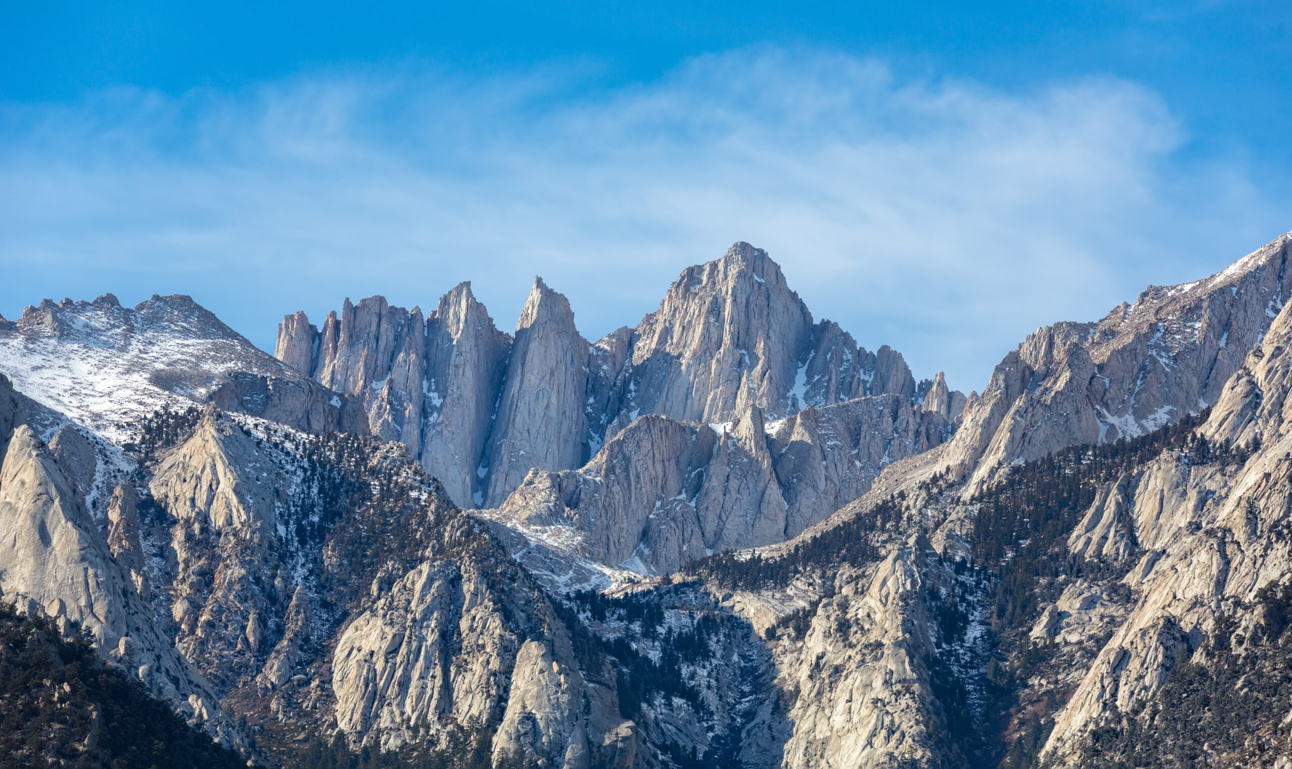
Mount Whitney rises 14,505 feet (4,421 meters) in the southern Sierra Nevada of California — the highest mountain in the contiguous United States. The Sierra escarpment here is dramatic: the eastern face drops approximately 11,000 vertical feet to the floor of Owens Valley below, one of the steepest mountain escarpments in North America. The mountain is part of a remarkable Sierra crest cluster — Mount Russell (14,094 ft), Mount Muir (14,012 ft), Mount Williamson (14,375 ft, the second-highest in California), and Mount Tyndall (14,019 ft) all sit within 8 km of Whitney’s summit.
Mount Whitney is famous for its remarkable geographic juxtaposition: 137 km / 85 miles east of the summit sits Badwater Basin in Death Valley — the lowest point in North America at 86 m / 282 ft below sea level. The total elevation contrast between the highest and lowest points in the contiguous US — a 4,507-meter vertical relief — exists across just 137 km of horizontal distance, the greatest elevation differential per unit of distance on the continent. This juxtaposition is the basis for the famous Badwater 135 ultramarathon (founded 1987), which races 217 km from Badwater Basin to Whitney Portal each July in temperatures up to 49°C (120°F).
Find Hotels, Flights & Trips for the World’s Best Hiking Destinations
The Global Summit Guide Travel Shop on Expedia — curated for outdoor adventurers, mountaineers, and serious hikers. Patagonia to the Alps. Nepal to the Rockies. Curated lodging for every region we cover.
Explore Travel Shop on Expedia →The Tübatulabal and Owens Valley Paiute names. Mount Whitney is in the ancestral territory of the Tübatulabal people (Kern River area) and the Eastern Sierra Paiute / Owens Valley Paiute people (Owens Valley). Both peoples have visited the Sierra crest for at least 4,000-7,000 years according to archaeological evidence. The Paiute name for Mount Whitney is sometimes recorded as Too-man-i-goo-yah, meaning approximately “the very old man” — though the exact name varies between Paiute communities and the documented historical record is incomplete. The Owens Valley Paiute Tribe and the Tubatulabals of Kern Valley continue to maintain cultural connections to the mountain and the surrounding Sierra crest. Climbers should be aware that the Whitney name (imposed in 1864 by Anglo-American geologists) is one of many names for the peak, and that the mountain was visited by Indigenous people for thousands of years before the 1873 first ascent.
1864: The California Geological Survey and the Whitney Name
The mountain was named in July 1864 by members of the California Geological Survey — specifically Clarence King, Charles Hoffmann, James Gardner, and William Brewer. Brewer’s party named it after their boss, Josiah Dwight Whitney (1819-1896), the state geologist of California and head of the California Geological Survey. Whitney himself never climbed his namesake mountain — at the time of the naming, his survey party had viewed it only from a distance.
The naming was characteristic of the Anglo-American geologist tradition: imposed names over Indigenous terminology, often honoring institutional leadership rather than the mountain’s actual character or local context. The naming has been challenged periodically — Josiah Whitney’s reputation has not aged well in California history (he became known for incorrect geological claims and contentious leadership) — but the name has stuck for 160+ years.
1864 and 1871: Clarence King’s Wrong-Mountain Climbs
In 1864, Clarence King (1842-1901) — one of the California Geological Survey members and later the first director of the US Geological Survey — attempted to climb Mount Whitney from the west side. He thought he had succeeded. King published a triumphant account of his “first ascent” of Mount Whitney that was widely celebrated in the geological and mountaineering communities of the period.
In 1871, King returned to climb the mountain again — and discovered, on a clearer day with better mapping, that he had climbed the wrong mountain in 1864. The peak he had actually climbed was Mount Langley (14,026 ft / 4,275m) — a separate peak approximately 8 km south of Whitney. Mount Langley is impressive but is not the highest in the Sierra. King had been misled by an inadequate map and uncertain terrain identification.
King’s confession is one of the great honest moments in 19th-century American science. He published a clear admission of the error and immediately set out to climb the actual Mount Whitney. His 1871 attempt to climb the real Mount Whitney was unsuccessful due to weather and route-finding difficulties. King wouldn’t reach the true summit until 1873 — by which time he had been beaten to it by three Lone Pine fishermen.
18 August 1873: The Begole-Johnson-Lucas First Ascent
The first verified ascent of Mount Whitney was made on 18 August 1873 by three local fishermen and stockmen from Lone Pine, California:
- Charles Begole — Lone Pine fisherman, longtime Owens Valley resident
- Albert Johnson — Lone Pine resident and friend of Begole
- John Lucas — Lone Pine resident, fisherman
The three men approached from Whitney Portal on the east side of the mountain via the route that is essentially the modern Mount Whitney Trail. They climbed up the canyon, gained the Sierra crest, and walked across what became the standard summit approach. They reached the summit on the afternoon of 18 August 1873 — and built a small summit cairn that has been preserved through subsequent ascents.
The Lone Pine fishermen had no scientific objective. They climbed Mount Whitney essentially because it was nearby and they were curious. They returned to Lone Pine the same day; their summit was reported in local newspapers within days. Their ascent beat the Sierra Club and the California Geological Survey parties to the summit by several weeks. Clarence King reached the true Mount Whitney summit on 21 September 1873 — five weeks after Begole, Johnson, and Lucas had already been there. King’s understandable disappointment is recorded in his correspondence with Josiah Whitney; the official Survey rationalized that “first scientific ascent” was different from “first ascent” but the Begole-Johnson-Lucas climb is universally recognized as the genuine first.
The 1873 Naming Controversy: “Fishermen’s Peak”
After the 1873 ascent, the Lone Pine community briefly attempted to rename Mount Whitney to “Fishermen’s Peak” in honor of Begole, Johnson, and Lucas. The name appeared in local newspapers and was used by Owens Valley residents for several years. However, the California Geological Survey’s official “Mount Whitney” designation prevailed in federal and academic mapping. The “Fishermen’s Peak” name is preserved in local historical records and occasionally referenced today as an alternative name reflecting the actual first-ascent story rather than the survey-imposed Whitney name.
1890: Sequoia National Park Established
The Sequoia National Park was established on 25 September 1890 — the second national park in the United States after Yellowstone (1872) and the first to specifically protect a species (the giant sequoia). The park boundaries originally included only the giant sequoia groves, but were extended over the following decades to eventually include Mount Whitney and the surrounding Sierra crest. The summit and west-side approaches are now within Sequoia National Park; the east-side approaches (Mount Whitney Trail from Whitney Portal) are in Inyo National Forest.
1904: John Muir’s Mount Whitney Climb
The famous Scottish-American naturalist and Sierra Club founder John Muir (1838-1914) climbed Mount Whitney in July 1904. Muir’s climb — at age 66 — was characteristic of his exploration tradition. His subsequent writings about the Sierra elevated Mount Whitney’s national prominence and contributed to the conservation movement that eventually protected the surrounding land. The John Muir Wilderness — the protected wilderness area that includes the eastern Whitney approaches — was named for Muir following his death and was officially designated as Wilderness in 1964.
1930s: The Mount Whitney Trail Built
The Mount Whitney Trail in its modern form was constructed during the 1930s by the Civilian Conservation Corps (CCC) and US Forest Service crews. Prior to that period, the route from Whitney Portal to the summit had been a series of informal use-paths and stockmen’s routes. The CCC engineering created the famous 97 switchbacks ascending the steep wall above Trail Camp (12,000 ft / 3,658m) to Trail Crest (13,650 ft / 4,160m) at the Sierra crest — switchbacks that have become an iconic feature of the climb.
1971-Present: The Permit System and Lottery
By the 1970s, the Mount Whitney Trail had become so popular that the unrestricted access was causing substantial environmental degradation. The permit quota system was implemented in 1971, initially with relatively loose limits, and progressively tightened over subsequent decades. The current system — daily quota of 100 day-hikers and 60 overnight permits during the May 1 to November 1 quota season — has been in place in similar form since the 2000s. The annual lottery system (application February 1-March 1, results March 15) was implemented to manage the increasingly competitive demand. The Mount Whitney lottery has become among the most competitive permit systems in the United States.
1987-Present: The Badwater 135 Ultramarathon
The Badwater 135 ultramarathon was founded in 1987. The race runs 217 km / 135 miles from Badwater Basin in Death Valley (-86 m below sea level) to Whitney Portal (2,548m / 8,360 ft above sea level), in summer temperatures that regularly exceed 49°C (120°F). The finish at Whitney Portal — though not at the actual Whitney summit — has made Mount Whitney synonymous with American ultra-endurance culture. The race has produced multiple celebrated finishes and is widely considered among the most challenging single-stage ultramarathons in the world.
The Highest in the Lower 48 — and Why Mount Whitney Is Different From Every Other Famous US Peak
Mount Whitney occupies a specific and unusual position in American mountaineering: it is the highest peak in the contiguous United States, but it is also a non-technical trail hike on its standard route. No other major peak in the world combines those two attributes at this scale — and the result is a mountain that draws an exceptionally diverse range of climbers and the most competitive permit system in the country.
What makes Whitney structurally distinct from other US classics:
- Mount Rainier (14,410 ft): Slightly lower than Whitney, but the standard route is a glaciated mountaineering objective requiring crampons, ice axe, rope teams, and crevasse rescue skills. Whitney’s standard route is a hike — no glacier, no rope team, no technical mountaineering.
- Mount Hood (11,250 ft): Lower than Whitney, but standard route is also a glaciated mountaineering objective with technical hazards. Whitney’s standard route involves none of these.
- Denali (20,310 ft, Alaska): Substantially higher than Whitney, but in Alaska — and is a 14-21 day expedition with full glaciated terrain. Whitney is a 1-3 day climb accessible by car.
- Colorado 14ers (~58 peaks): Lower than Whitney (highest is Mount Elbert at 14,440 ft). Most are non-technical hikes similar in character to Whitney but at slightly lower altitude.
The result of this distinct character:
- Permit demand is extreme. The Mount Whitney lottery receives roughly 30,000-40,000 applications per year for ~100 daily slots during the 6-month quota season. The peak-season weekend dates can have 15-20+ applicants per slot.
- The Whitney climbing population is unusually diverse. Day hikers from Los Angeles, weekend warriors from San Francisco, Sierra Club veterans, ultra-marathoners on training runs, retirees on bucket lists, and high-altitude mountaineers using Whitney as Sierra acclimatization all share the trail. No other major US peak has this kind of demographic breadth.
- Annual fatalities are unusually low for the popularity. Despite the altitude, the non-technical character of the standard route means Mount Whitney has fewer climbing fatalities per attempt than virtually any other peak above 14,000 feet in the US. Most Whitney deaths involve altitude sickness (HACE/HAPE), cardiac events, or lightning strikes — not climbing accidents.
- The Whitney/Badwater axis is iconic. The Mount Whitney to Badwater Basin elevation contrast — 4,507 m of vertical relief across 137 km of horizontal distance — is the largest in North America. The Badwater 135 ultramarathon has made this geographic juxtaposition globally famous in endurance sport circles.
Where Whitney fits in American mountaineering progression: Mount Whitney is excellent as a high-altitude acclimatization peak for climbers building toward Rainier, Denali, Aconcagua, or Himalayan objectives. The 22-mile distance and 6,650-foot elevation gain provide genuine endurance training; the 14,505-foot altitude provides genuine altitude exposure. As a standalone summit goal, Whitney is the natural US “first major peak” for fit hikers — more accessible than Rainier, harder than Colorado 14ers, more remote than the easiest state high points. As a technical mountaineering objective, the Mountaineers Route alternative provides class 3-4 scrambling and snow climbing that opens the door to harder Sierra peaks.
Mount Whitney Historical Timeline
Archaeological evidence places the Tübatulabal people (Kern River area) and Owens Valley Paiute people (Owens Valley) in the Sierra crest region for at least 4,000-7,000 years. Mount Whitney — called Too-man-i-goo-yah (“the very old man”) by some Paiute communities — is sacred to multiple Sierra tribes.
Clarence King, Charles Hoffmann, James Gardner, and William Brewer of the California Geological Survey name the mountain after their boss Josiah Dwight Whitney — without ever climbing it. The survey party views the peak only from a distance.
Clarence King climbs Mount Langley in 1864 thinking it is Mount Whitney. Publishes a triumphant “first ascent” account. In 1871, returns and discovers his error. Attempts the actual Whitney in 1871 but is turned back by weather. His honest admission of the error becomes one of the great moments in 19th-century American science.
Three Lone Pine fishermen — Charles Begole, Albert Johnson, and John Lucas — make the first verified ascent of Mount Whitney via what becomes the modern Mount Whitney Trail. They return to Lone Pine the same day. Their summit is reported in local newspapers within days. Beats Clarence King to the summit by five weeks.
Five weeks after the Lone Pine fishermen, Clarence King reaches the actual Mount Whitney summit. The California Geological Survey describes this as the “first scientific ascent” — but the genuine first ascent is universally credited to Begole, Johnson, and Lucas.
The Lone Pine community attempts to rename Mount Whitney to “Fishermen’s Peak” in honor of Begole, Johnson, and Lucas. The name appears in local newspapers and is used by Owens Valley residents for several years. The California Geological Survey’s official “Mount Whitney” name prevails in federal mapping.
President Benjamin Harrison signs legislation establishing Sequoia National Park — the second national park in the United States after Yellowstone (1872). Park boundaries are subsequently expanded to include Mount Whitney’s summit, though east-side approaches remain in what becomes Inyo National Forest.
The famous Scottish-American naturalist and Sierra Club founder John Muir climbs Mount Whitney at age 66. His writings about the climb elevate the mountain’s national prominence and contribute to the conservation movement. The John Muir Wilderness — designated 1964 — eventually protects the east-side Whitney approaches.
The Smithsonian Institution builds a small stone shelter on the summit of Mount Whitney to house solar observation equipment. The shelter — visible today — was used for high-altitude atmospheric research through the early 20th century and remains as a historic structure on the summit.
The Civilian Conservation Corps (CCC) and US Forest Service crews construct the modern Mount Whitney Trail with its iconic 97 switchbacks ascending the steep wall above Trail Camp. The engineered trail replaces informal use-paths and becomes the standard climbing route still used today.
The John Muir Wilderness — including the east-side approaches to Mount Whitney — is officially designated under the Wilderness Act of 1964. The protected status formalizes the wilderness character of the eastern Sierra and limits future development.
The Mount Whitney Trail becomes one of the first major US trails to implement a permit quota system to manage growing visitor pressure. Initial limits are relatively loose; subsequent decades progressively tighten the quotas to current levels (100 day hikers + 60 overnight permits per day during quota season).
The Badwater 135 ultramarathon is established, running 217 km / 135 miles from Badwater Basin in Death Valley (-86m) to Whitney Portal (2,548m). The race becomes globally famous in endurance circles. The Whitney/Badwater elevation contrast — the largest in North America — becomes synonymous with American ultra-endurance culture.
The Mount Whitney lottery — application February 1 to March 1, results March 15 — becomes among the most competitive permit systems in the US. Annual applications grow from ~10,000 to 30,000+. Peak-season weekend dates routinely receive 15-20+ applicants per slot. Recreation.gov modernizes the application process.
The 2022-2023 Sierra winter produces record snowpack. Mount Whitney Trail remains snow-covered into August 2023. Many lottery winners turn back at the 97 switchbacks; technical alternative routes become more popular. The season demonstrates how dramatically snowpack variability affects “non-technical” trail conditions.
Continuing lottery pressure prompts discussion of permit reforms. The 2025 season runs under the existing lottery framework with no major changes. Badwater 135 finish at Whitney Portal in July 2025 again draws international attention. Lottery applications stay at 30,000+ for ~14,500 annual permit slots.
The Mount Whitney Routes
Mount Whitney has two principal climbing lines used by virtually all summit climbers — the Mount Whitney Trail (the standard route) and the Mountaineers Route (the technical alternative). A handful of harder routes are climbed by experienced alpinists.
| Route | Side | Style | First Ascent | Status |
|---|---|---|---|---|
| Mount Whitney Trail | East (Whitney Portal) | Non-technical hike (in summer) | 18 Aug 1873 (Begole/Johnson/Lucas) | ● Open · Standard · ~95% of ascents |
| Mountaineers Route | East (N. Fork) | Class 3-4 scramble + snow couloir | 1873 (likely) | ● Open · Technical Alternative |
| High Sierra Trail / John Muir Trail | West | Long backcountry approach | Various 1880s-1900s | ● Open · Multi-day backcountry |
| East Buttress | East | Technical rock climb (5.7) | 1937 | ● Open · Experienced Climbers |
| East Face | East | Technical rock climb (5.7) | 1931 | ● Open · Experienced Climbers |
| Keeler Needle | East | Technical rock climbing (5.10) | Various | ● Open · Expert Only |
Mount Whitney Trail — The Standard Route (Begole’s 1873 Line)
Style: Non-technical hiking trail in snow-free summer conditions · Used by ~95% of climbers.
Trailhead: Whitney Portal (8,360 ft / 2,548m), 21 km / 13 miles west of Lone Pine via Whitney Portal Road. Small visitor area with parking, store, picnic area, and trailhead. The Whitney Portal store is famous for its pancakes — a Lone Pine tradition before or after the climb.
The Climb: 22 miles round trip · 6,650 feet of elevation gain · 4,421m summit altitude:
- Whitney Portal (8,360 ft) → Outpost Camp (10,360 ft): Initial 3.8 mile / 6 km climb through Lone Pine Creek canyon. Granite steps, switchbacks, lodgepole pine forest. ~2-3 hours.
- Outpost Camp (10,360 ft) → Mirror Lake (10,640 ft): Short section to the iconic alpine lake. Often a rest stop. ~30 minutes.
- Mirror Lake → Trail Camp (12,000 ft): Continued ascent through alpine terrain to the high camp area. Most overnight climbers stage here for Day 2 summit attempts. ~2-3 hours from Outpost.
- Trail Camp (12,000 ft) → Trail Crest (13,650 ft) via 97 Switchbacks: The most famous and most arduous section of the climb. 97 numbered switchbacks ascend the steep wall between Trail Camp and the Sierra crest at Trail Crest. ~1,650 vertical feet of switchbacks. ~2-3 hours. The switchbacks are the section that retains snow longest in early season — when snow-covered, they require crampons and ice axe, and the climb becomes a technical snow route rather than a hike.
- Trail Crest (13,650 ft) → Summit (14,505 ft): Final 2 miles along the Sierra crest with substantial exposure and views into both Owens Valley (east) and the Sequoia backcountry (west). The trail passes “Trail Crest Junction” where John Muir Trail/Pacific Crest Trail traffic joins the Whitney Trail. ~2-3 hours from Trail Crest to summit.
- Summit (14,505 ft): Marked by the historic 1907 Smithsonian solar observatory shelter. Sign-in register. Summit views include Sequoia backcountry, the Sierra crest cluster, and on clear days Owens Valley below.
Times: Day hikers: 10-16 hours round trip (12-13 hours average). Overnight climbers: 2-3 day itineraries are common, with Trail Camp as the high camp.
Permit: Mount Whitney Trail permit (lottery distributed during quota season May 1 – November 1).
Mountaineers Route — The Technical Alternative
Style: Class 3-4 scrambling + snow couloir + occasional roped sections.
Trailhead: Also Whitney Portal, but the route follows the North Fork of Lone Pine Creek trail rather than the main Whitney Trail.
The Climb: Approximately 13 km / 8 miles round trip with 6,200 feet of elevation gain. Significantly shorter than the standard trail but substantially more technical:
- North Fork approach: Cross-country travel through brush and granite ledges. Class 2-3 scrambling required. Many parties find this approach challenging in itself. The route gains the Lower Boy Scout Lake (10,300 ft) and Upper Boy Scout Lake (11,300 ft) areas — popular high-camp locations for technical Whitney climbers.
- Iceberg Lake (12,640 ft): Alpine lake at the base of the technical climbing. Many parties stage here for the final summit push.
- Mountaineers Route Couloir: The route’s namesake — a steep snow/ice couloir ascending to a notch at approximately 14,000 feet. In early season, this is the technical crux: 40-45° snow with limited protection. In summer when the snow melts out, the route becomes class 3-4 scrambling on the rocky couloir wall.
- Final 500 feet to summit: Class 3-4 scrambling on the upper rocks to the summit. Some parties prefer to rope up; experienced scramblers move unroped.
Times: 8-10 hours round trip for fit climbers in good conditions; faster for elite scramblers. Many parties make this an overnight climb staging at Upper Boy Scout Lake or Iceberg Lake.
Why climbers choose it: Faster ascent than the long Whitney Trail. More mountaineering character. Less crowded — the Mountaineers Route attracts a different demographic than the trail. Substantially better as a snow-climbing objective in spring/early summer than the Whitney Trail’s switchback section.
Permit: Separate permit category — the North Fork day-use permit. Cannot be substituted with a Whitney Trail permit. This is one of the most common permit-confusion errors among climbers.
High Sierra Trail and John Muir Trail (Backcountry Approaches)
Style: Multi-day backcountry backpacking from the west side of the Sierra.
High Sierra Trail: The 72-mile / 116-km High Sierra Trail runs from Crescent Meadow in Sequoia National Park to Whitney Portal, crossing the Sierra crest near Whitney summit. Typically 7-10 days backpacking. Climbers can choose to summit Whitney as the climax of the route. Approach permits handled through Sequoia National Park.
John Muir Trail: The famous 211-mile / 340-km John Muir Trail runs from Yosemite Valley to Mount Whitney summit, traversing the eastern Sierra crest. Most JMT hikers summit Whitney as the southern terminus of the route — typically Day 18-22 of the through-hike. JMT permits are handled separately from Whitney Trail permits but include Whitney summit privileges for backpackers reaching the mountain via the JMT.
Why climbers choose it: The backcountry approaches provide a substantially different experience — multi-day wilderness expedition rather than single-day summit push. The aesthetic value is significant; the John Muir Trail in particular is widely considered one of the great long-distance hikes in North America. Many climbers complete the JMT specifically to summit Whitney as the southern terminus.
Permit: JMT / High Sierra Trail permits are obtained through their respective trailhead lotteries (Yosemite, Sequoia, etc.). These are separate from Whitney-specific permits.
East Face, East Buttress, and Keeler Needle — Technical Rock Routes
East Face (1931): First climbed by Robert Underhill with Sierra Club partners in 1931 — one of the earliest technical rock climbs in the Sierra. Grade III, 5.7 rock climbing on the steep east face of Mount Whitney. Approximately 1,500 feet of climbing from the base. Among the classic California rock climbs.
East Buttress (1937): First climbed by Glen Dawson, Bill Rice, and others — established the East Buttress as a Sierra classic. Grade III, 5.7 rock climbing on the buttress dividing the East Face from the upper South Face. Similar character to the East Face.
Keeler Needle: A separate pinnacle on the Whitney massif climbed by various routes from 5.10 to 5.12. Among the technical rock-climbing classics of the Sierra. Names like Joe Brown, John Salathé, Royal Robbins, and Yvon Chouinard appear in the route’s history.
Modern status: The Mount Whitney technical rock routes are climbed by perhaps 50-100 parties per year total. These routes require significant prior rock-climbing experience — multiple comparable Sierra climbs (Cathedral Peak, the Eichorn Pinnacle, the Cardinal Pinnacle, etc.) at minimum. Approach is via the same North Fork drainage as the Mountaineers Route. Sierra rock climbing in general is considered among the most aesthetic in the world.
The Whitney Trail Progression
The standard Mount Whitney Trail progresses through these named locations from trailhead to summit. Most climbers spend significant time at the highlighted “high camp” locations (Outpost Camp or Trail Camp) for acclimatization or overnight staging:
The Whitney Zone has strict food storage and waste regulations. All food, scented items, and trash must be stored in approved bear canisters — black bears are active throughout the area. Human waste must be packed out using WAG bags (Waste Alleviation and Gelling) issued at the trailhead — there are no privies above Trail Camp. The “pack it out” rule is rigorously enforced; rangers actively monitor compliance. Climbers caught with improper food storage or waste handling face permit revocation and substantial fines.
Costs & 2026 Permits
Mount Whitney is one of the most affordable major US peak climbs — there are no commercial guide service requirements, gear rental is widely available in Lone Pine, and the trail can be completed independently. The main costs are the permit (if won), gas/lodging, food, and gear. Guided programs are available but optional. The permit lottery is the dominant logistical challenge.
| Item | Cost | Notes |
|---|---|---|
| Mount Whitney lottery application fee | $6 | Non-refundable; per group; February 1 – March 1 application window |
| Mount Whitney permit (if won) | $15-$20 per person | Day-use or overnight; paid through Recreation.gov |
| Mountaineers Route (North Fork) permit | $15-$20 per person | Separate permit category from Whitney Trail |
| JMT / High Sierra Trail permits | Varies by entry point | Distinct lottery from Whitney; Yosemite/Sequoia entries |
| Off-season self-issued permits (Nov-Apr) | $0 | Available at trailheads outside quota season; no quota |
| Lone Pine lodging (per night) | $80-$200 | Best Western, Dow Villa Motel, Whitney Portal Hostel, etc. |
| Whitney Portal Campground | $23/night | Limited sites near trailhead; books out far in advance |
| Lone Pine gear rental (boots, axe, etc.) | $50-$200 | Whitney Portal Gear Rental, Sierra Mountain Center, etc. |
| Travel from LA / SFO | $50-$200 gas + car rental | Lone Pine is on US-395; 4-5 hr from LA, 6-7 hr from SF Bay |
| Travel insurance (recommended) | $30-$100 | Standard high-altitude domestic policy |
| Sierra Mountain Center guided 2-day climb | $650-$900 | Per climber; includes guide, group gear; some pre-climb instruction |
| Premium Mountaineers Route guided (3-4 days) | $1,200-$2,000 | Higher-touch programs with technical instruction |
| Independent day-hike budget | $50-$250 | Permit + gas + food (assuming local lodging or camping; gear owned) |
| Independent overnight budget | $200-$500 | Permit + 2-3 nights lodging + food + bear canister rental + gear |
| Guided trip total budget | $1,000-$2,500 USD | Including travel, lodging, gear rental, guide fee |
The Mount Whitney lottery — how it actually works. The lottery runs annually with these key dates: February 1 – March 1 application window ($6 application fee, Recreation.gov). Each application can request up to 15 alternate dates and is for a specific group size. Results posted March 15. Successful applicants pay the permit fee ($15-$20 per person) within 14 days to confirm. April 22 unclaimed dates released on a first-come-first-served basis through Recreation.gov. After May 1, any remaining permits or last-minute cancellations are released on a daily basis. Lottery success rate by date: Peak-season weekend day-use applications have ~5-10% success rate. Mid-week dates in shoulder season (early May, late October) have ~30-50% success rates. Overnight permits are generally easier to win than day-use permits. Climbers willing to be flexible on dates and to camp instead of day-hiking substantially improve their odds.
Common permit-confusion errors that ruin Whitney trips. (1) Wrong route permit: The Whitney Trail permit does NOT allow Mountaineers Route access, and vice versa. Climbers who win Trail permits and decide to attempt the Mountaineers Route on summit day will be turned back by rangers. (2) Day-use vs overnight: Day-use permits are midnight-to-midnight and do not allow camping anywhere in the Whitney Zone. If you want to camp at Trail Camp or Outpost, you need an overnight permit. (3) Group size: Your permit lists a specific number of climbers; you cannot bring extras. (4) Date specificity: Your permit is for a specific date. You cannot use it the day before or after. (5) Trailhead pickup required: Permits must be physically picked up at the Eastern Sierra InterAgency Visitor Center in Lone Pine or self-printed and carried; rangers check at the trailhead.
Best Time to Climb & Sierra Nevada Weather
The Mount Whitney climbing season runs effectively from mid-July through early October in typical snowpack years. Spring conditions (April-June) require winter mountaineering skills; winter conditions (November-March) require full expedition competence.
| Period | Window | Conditions | Watch For |
|---|---|---|---|
| Winter | December – March | Heavy snow; cold; technical winter mountaineering only | Avalanche hazard; extreme cold (-20°C+); only experienced winter mountaineers |
| Spring Conditions | April – June | Snow remaining on upper trail; 97 switchbacks still snowy | Ice axe + crampons mandatory; self-arrest skills required; substantially more serious |
| Early Summer | July (low-snow years) | Trail beginning to clear; some snow on switchbacks possible | Variable conditions year to year; storms more frequent |
| Prime Season | Late July – September | Snow-free trail in normal years; warm days; clear weather typical | Afternoon thunderstorms; permit competition; peak crowds |
| Late Season | October | Cooler temperatures; thinner crowds; quota season ends Nov 1 | Earlier sunset; first new snow possible; gear shops winding down |
| Quota Season Ends | November 1 – April 30 | Off-season; self-issued permits at trailhead; no quota | Winter mountaineering competence required; Whitney Portal Road may be closed |
The Mount Whitney start time decision. Day-hikers face a critical decision: start in the dark or start at dawn. Most successful Whitney day-hikers start between 1:00 AM and 4:00 AM — multiple hours before sunrise — to allow the full 10-16 hours of climbing time before darkness returns. Starting at dawn (~5:30 AM in summer) compresses the climbing window and typically results in either summit failure or late descent in the dark. Headlamps are mandatory. Many climbers underestimate how cold pre-dawn temperatures are at high altitude — even in August, Trail Camp morning temperatures often drop below freezing. Layers, gloves, and warm hat are essential.
Afternoon thunderstorms — the most common cause of Whitney summit failures. Sierra Nevada summer weather follows a predictable pattern: clear mornings, building cumulus clouds through midday, frequent afternoon thunderstorms with lightning. Climbers who don’t summit by approximately 11 AM to 12 PM face elevated lightning risk on the exposed summit ridge. The Smithsonian summit hut from 1907 has been struck by lightning multiple times and is not safe shelter — it provides limited protection from rain but no protection from lightning strikes. Climbers caught above Trail Crest in an electrical storm should retreat below 12,000 feet immediately, even if the summit is within easy reach. Numerous Whitney lightning fatalities document this hazard. The afternoon thunderstorm reality is the single most important reason for the very early start times.
Essential Gear Checklist
Mount Whitney gear requirements depend dramatically on season. Summer trail conditions require standard high-altitude day-hiking gear. Spring/early summer snow conditions require crampons, ice axe, and self-arrest competence. The Mountaineers Route in any condition requires technical climbing gear.
Summer Trail (Standard Route, July-Oct)
- Trail running shoes or sturdy hiking boots
- Synthetic or merino base layers
- Lightweight insulating mid-layer (fleece or down jacket)
- Rain jacket / shell (lightweight)
- Sun hat, baseball cap, or wide-brim hat
- Buff or neck gaiter (sun protection)
- Lightweight gloves for pre-dawn cold
- Sunglasses (Category 3-4)
- Headlamp + spare batteries (mandatory for early starts)
Spring/Early Summer Snow (April-June)
- Mountaineering boots B1-B2: La Sportiva Trango, Scarpa Mont Blanc
- Crampons with anti-balling plates (Petzl Vasak, Black Diamond Sabretooth)
- Ice axe (general mountaineering, 60-65cm)
- Self-arrest practice essential
- Heavier insulation system (insulated jacket, warm hat)
- Hardshell jacket + pants
- Goggles (in addition to sunglasses)
- Heavier gloves + mitten reserve
- Climbing harness + helmet (for Mountaineers Route)
Hydration & Food Strategy
- Minimum 3-4 liters water for day-hike (more in heat)
- Water filter for refilling from Lone Pine Creek (mandatory)
- Electrolyte tablets / sports drink mix (altitude depletes electrolytes)
- 2,500-4,000 calories of energy food (gels, bars, sandwiches)
- Extra reserve food for emergencies
- Caffeinated drinks/gels for the long day
Essential Other Gear
- 30-40L day pack (or 50-65L for overnight)
- Bear canister (mandatory for overnight; rental available in Lone Pine)
- WAG bags (Waste Alleviation and Gelling — pack out human waste; issued at trailhead)
- Trekking poles (knees + balance for long descent)
- Sunscreen (SPF 50+), lip balm with SPF
- First aid kit + blister kit
- Map + compass + Whitney trail guide
- GPS or smartphone with offline maps
- Permit + identification (rangers check)
- Cash for Whitney Portal store (pancakes!)
Difficulty & What Mount Whitney Actually Demands
Mount Whitney is misleadingly described as “a hike.” The standard route is non-technical in summer conditions, but the combination of 22 miles, 6,650 feet of elevation gain, and 4,421m altitude makes it substantially more demanding than virtually any other hike most climbers will have done. Five specific characteristics define what the mountain actually demands:
1. The distance is genuinely large. 22 miles round trip is not a casual day hike — it’s a marathon equivalent at altitude. Climbers who arrive thinking “it’s just a long hike” frequently discover their longest previous hike was 8-10 miles at sea level. The Mount Whitney Trail effectively requires the endurance of a marathon, run in hiking boots with a backpack at altitude. Training is genuinely necessary: many climbers prepare with weekly long hikes of 15+ miles for several months before the attempt.
2. The altitude is the most common failure cause. 4,421m is high enough to produce moderate-to-severe altitude sickness (AMS) in unacclimatized climbers. Approximately 30-40% of attempts fail to summit, with altitude-related symptoms (headache, nausea, severe fatigue, HAPE in rare cases) being the most common failure cause. Climbers driving from sea level (Los Angeles, San Francisco) to Lone Pine and attempting the climb the next day have substantially higher failure rates than those who spend 1-2 days at higher elevations (Mammoth Lakes, Whitney Portal campground) before the attempt.
3. The weather window is narrow. Sierra Nevada summer afternoon thunderstorms force climbers to summit by approximately 11 AM-12 PM. The very early start times (1-4 AM) exist specifically to allow time to summit and descend before storms develop. Climbers caught in afternoon storms on the exposed summit ridge face genuine lightning risk — multiple Mount Whitney lightning fatalities document this hazard. Trust the weather forecast; trust the turnaround time; if you can’t summit by noon, descend immediately.
4. The 97 switchbacks are the psychological crux. The 1,650-vertical-foot switchback section between Trail Camp and Trail Crest is the most arduous part of the climb. Climbers ascending at 12,000+ feet on minimal sleep face genuine physical limits. Most climbers who turn back voluntarily do so at the switchbacks — not at the summit. The switchbacks teach a hard lesson about altitude, fatigue, and the gap between trail-running fitness and altitude fitness. Climbers who can’t ascend the switchbacks should not be on Mount Whitney that day.
5. Spring/early-summer conditions transform the climb. When snow covers the upper trail — typically May, June, and parts of July — what looks like a “non-technical trail” on Google becomes a genuine snow climb requiring crampons, ice axe, and self-arrest competence. Climbers attempting the snow-covered trail without proper gear and skills routinely slide hundreds of feet down the switchback slopes; multiple injuries and several deaths have resulted. Check current trail conditions before the climb — the Inyo National Forest website posts updated snow reports each week during the transition seasons.
What Mount Whitney rewards: Climbers with multi-thousand-foot elevation gain hikes already in their résumé, marathon-equivalent endurance training, 1-2 days of altitude acclimatization at 7,000-8,000 ft elevation before the attempt, willingness to start in the dark (1-4 AM), discipline to turn around at the noon weather window, and proper gear for current conditions (especially snow gear in spring). As a standalone US goal, Mount Whitney is excellent — it’s a genuinely impressive summit that fit, well-prepared hikers can achieve without technical climbing experience. As preparation for higher peaks (Rainier, Denali, Aconcagua), Whitney teaches altitude management, endurance pacing, and weather discipline that translate directly. As a technical mountaineering objective, the Mountaineers Route alternative opens the door to harder Sierra peaks. As a “casual hike” — no, this is not that. Approach Mount Whitney with respect for what 22 miles + 6,650 vertical feet + 4,421m altitude actually means.
Featured Guide Services & Operators
Mount Whitney’s non-technical standard route means most climbers go independently — guide services are optional. However, guided programs significantly improve success rates for first-time high-altitude climbers, snow-condition climbers, and Mountaineers Route attempts. Below are the established Mount Whitney guide operators.
Sierra Mountain Guides
Based in Bishop, California, Sierra Mountain Guides is among the most established Sierra-focused guiding services. AMGA-certified guides offer Mount Whitney programs including the standard trail (2-day program), Mountaineers Route (3-day program), and winter ascents for experienced climbers. Strong reputation for Sierra-specific knowledge and altitude management. sierramountainguides.com/mount-whitney
Sierra Mountain Center
Based in Bishop, Sierra Mountain Center operates Mount Whitney programs alongside Sierra Nevada rock climbing, mountaineering, and winter skills courses. AMGA-certified guides; flexible scheduling; competitive pricing for guided 2-day Whitney climbs. Provides gear rental and pre-climb instruction. sierramountaincenter.com
Whitney Portal Guides
Local Lone Pine-area guide service specializing in Mount Whitney. Smaller operation than the Bishop-based services but with intimate Whitney Portal area knowledge and convenient local logistics. Custom programs for groups and individual climbers. whitneyportalguides.com
Sierra Wilderness Guides
Sierra-specific guiding service offering Mount Whitney programs alongside Sierra peakbagging, John Muir Trail support, and Yosemite climbing. Strong reputation for backcountry programs combining Whitney with longer Sierra traverses. sierrawilderness.com
RMI Expeditions (Mountaineers Route)
The famous Mount Rainier guide service (founded by Lou Whittaker in 1969) occasionally offers Mount Whitney Mountaineers Route programs as Sierra acclimatization for clients building toward Rainier or Denali. RMI’s Whitney programs are infrequent but high-quality. rmiguides.com
Alpine Ascents International (occasional)
Seattle-based premium operator occasionally offers Mount Whitney programs in conjunction with Sierra mountaineering courses. Higher per-climber pricing; smaller groups; strong educational component. Useful for climbers building toward harder objectives. alpineascents.com
Frequently Asked Questions
Mount Whitney rises to 4,421 meters (14,505 feet) in the Sierra Nevada of California. It is the highest mountain in the contiguous United States — meaning the highest peak in the lower 48 states, excluding Alaska where Denali (6,190m / 20,310 ft) is substantially higher. Mount Whitney sits on the boundary between Inyo National Forest (east side, Owens Valley) and Sequoia National Park (west side). The summit is approximately 136 km / 85 miles east of Fresno and 360 km / 224 miles northeast of Los Angeles. The mountain is famous for its remarkable proximity to Badwater Basin in Death Valley — the lowest point in North America at 86 m below sea level — which sits only 137 km / 85 miles to the east in a direct line.
The first ascent of Mount Whitney was made on 18 August 1873 by three fishermen from Lone Pine, California: Charles Begole, Albert Johnson, and John Lucas. They climbed via what is essentially the modern Mount Whitney Trail from Whitney Portal — the route they pioneered remains the standard climbing route 152 years later. Their ascent beat a competing party from the California Geological Survey by a matter of weeks. A separate Sierra Club party led by Clarence King had attempted Mount Whitney in 1864 and 1871 but climbed the wrong mountain (Mount Langley, 14,026 ft) on both occasions due to mapping errors. The 1873 Begole-Johnson-Lucas ascent is verified by their summit cairn and by the contemporary newspaper accounts of their return to Lone Pine on the same day.
The Mount Whitney Trail (the standard route) is non-technical in normal late-summer conditions — meaning no ropes, technical climbing gear, or mountaineering skills required for snow-free travel. However, in spring and early summer when snow and ice cover the upper trail, the route requires ice axe, crampons, and self-arrest skills to safely descend the steep slopes below the summit. The Mountaineers Route (the second-most-popular route, via the North Fork of Lone Pine Creek) is genuinely technical — class 3-4 scrambling with steeper snow couloirs and substantial route-finding demands. The two routes are not interchangeable permit choices: the Whitney Trail permit does not allow access to the Mountaineers Route, and vice versa.
Mount Whitney requires a wilderness permit year-round for entry into the Whitney Zone. During the May 1 – November 1 quota season, permits are distributed through an annual lottery system run by Recreation.gov: applications open February 1 through March 1, results posted March 15, unclaimed dates released April 22. Day-use permits (midnight-to-midnight, no consecutive days) and overnight permits are managed separately, with different quotas. The standard Whitney Trail and the Mountaineers Route have different permit categories. Outside the quota season (November-April), self-issued permits are available at trailheads or via Recreation.gov. The lottery is among the most competitive permit systems in the US — peak-season weekend dates typically receive 10-20+ applications per permit slot.
Most day hikers complete Mount Whitney in 10-16 hours round trip from Whitney Portal, with strong hikers averaging 12-13 hours. The standard Whitney Trail is approximately 22 miles round trip with 6,650 feet of elevation gain — substantially longer and steeper than most day hikes. Many hikers split the climb into 2-3 days by staging at Trail Camp (12,000 ft / 3,658m) for the first night, summiting on Day 2, and descending. Overnight permits are typically less competitive than day-use permits despite covering the same trail. The Mountaineers Route is significantly faster on the ascent — 8-10 hours round trip is typical for fit climbers — but requires technical climbing skills. The fastest known time for the standard route is approximately 4 hours up and 2 hours down.
The main Mount Whitney climbing season runs from mid-July through early October, with the most reliable snow-free trail conditions typically from late July through September. In typical low-snowpack years, the trail can be snow-free by mid-July; in heavy snow years (like 2023 after the record Sierra winter), portions of the trail remain snow-covered into August or September. Spring conditions (April-June) require crampons, ice axe, and self-arrest skills — what hikers think of as “the trail” becomes a technical snow climb. Winter ascents (December-March) are possible but require full winter mountaineering competence. Most thunderstorm activity occurs in late July through August; summit attempts should plan to be off the summit by early afternoon to avoid lightning.
Mount Whitney is technically non-technical on the standard route in snow-free summer conditions — making it possible for a very fit, well-prepared beginner. However, the combination of 22 miles, 6,650 feet of elevation gain, and 4,421m altitude makes Whitney substantially more demanding than most beginner hikes. Most failed Whitney attempts fail due to altitude sickness (AMS), exhaustion from the long day, dehydration in the dry desert climate, or storms forcing turnaround. Beginners should: (1) train extensively with multi-thousand-foot vertical gain hikes, (2) acclimatize for 1-2 days at Whitney Portal (8,360 ft) before summit attempts, (3) start the climb in the dark (3-4 AM start times are typical), (4) carry plenty of water and electrolytes, and (5) be willing to turn back if AMS develops. Hiring a guide significantly improves success rates for first-time high-altitude climbers.
Mount Whitney sits in the Sierra Nevada of California, on the boundary between Inyo National Forest (east side) and Sequoia National Park (west side). Coordinates: 36.5785°N, 118.2923°W. The standard approach is from Whitney Portal (8,360 ft / 2,548m) — a small visitor area 21 km / 13 miles west of Lone Pine, California in Owens Valley. Lone Pine itself is approximately 360 km / 224 miles northeast of Los Angeles via US-395. Mount Whitney is famously 137 km / 85 miles in a direct line from Badwater Basin in Death Valley — the lowest point in North America at 86 m below sea level. This juxtaposition makes the Badwater-to-Whitney route one of the most extreme elevation transitions in North America and the basis of the Badwater 135 ultramarathon.
Mount Whitney Map & Lone Pine Weather
Mount Whitney summit coordinates: 36°34’43″N 118°17’32″W (36.5785°N, -118.2923°W). The map below shows the summit’s position in the Sierra Nevada. Live weather is shown for Lone Pine, CA (1,136m / 3,727 ft) — the main staging town. Summit conditions are typically 22-30°C colder than Lone Pine; Whitney Portal trailhead is approximately 15°C colder than Lone Pine.
Was this helpful?
🏔Related peaks nearby
🧭Explore & compare
Global Summit Guide is an independent mountaineering resource founded in 2026. The team combines first-hand trekking and climbing experience with in-depth research and professional health and nutrition review to help climbers choose objectives, prepare properly, and stay safe.
Health, altitude, and nutrition content is reviewed by Taylor Ludlow (Registered Nurse) and Brigg Hoopes (Nutritionist).
What We Don't Know Yet
Mountain information changes quickly. This box explains the limits of what this page can responsibly promise.
- Permit availability, reservation windows, quotas, and official fee rules may change after this page is updated.
- Weather, snowpack, avalanche risk, road access, and route conditions can change quickly and may be different on your climbing dates.
- Route conditions, trailhead access, crevasse exposure, stream crossings, and rescue access may vary from published planning guidance.
- Gear requirements can change by season, route variation, weather window, personal cold tolerance, and guide-service requirements.
Verify current conditions with official land managers, guide services, local forecasts, and current route reports before booking or climbing.
Part of this Global Summit Guide cluster
Explore the complete Mountains guide for more context, routes, planning links, and related resources.
Mountaineering, rock and ice climbing, glacier travel, and high-altitude activity are inherently dangerous and can result in serious injury or death. The information on Global Summit Guide is provided for general informational and educational purposes only and is not a substitute for professional instruction, qualified guiding, proper equipment, or your own judgment and experience.
Route conditions, weather, snowpack, permits, regulations, and hazards change constantly and may differ from what is described here. Details may be incomplete, out of date, or contain errors. Always verify current information with local authorities, certified guides, and official sources before making any decision in the mountains.
Nothing on this site is medical, legal, or financial advice. Our fitness, acclimatization, altitude, and nutrition content is general in nature; consult a qualified physician before beginning any strenuous exercise program or exposing yourself to high altitude.
You are solely responsible for your own safety and decisions. To the fullest extent permitted by law, Global Summit Guide and its team accept no liability for any loss, injury, damage, or expense arising from use of, or reliance on, this information. By using this site you acknowledge these risks and accept these terms.
Some links on this site may be affiliate links. If you buy through them we may earn a small commission at no extra cost to you; this never affects our recommendations.
Global Summit Guide recommendation path
Next Best Mountain to Research
Use these recommendations to continue the right planning path instead of stopping on one page.
Use current permit, weather, route, and operator information before booking or climbing.