
Last updated March 20, 2026
Mount Roraima – Brazil, Guyana and Venezuela
Mount Roraima Guide: Trek Route, Plateau Highlights, Season, Logistics, Gear & Safety
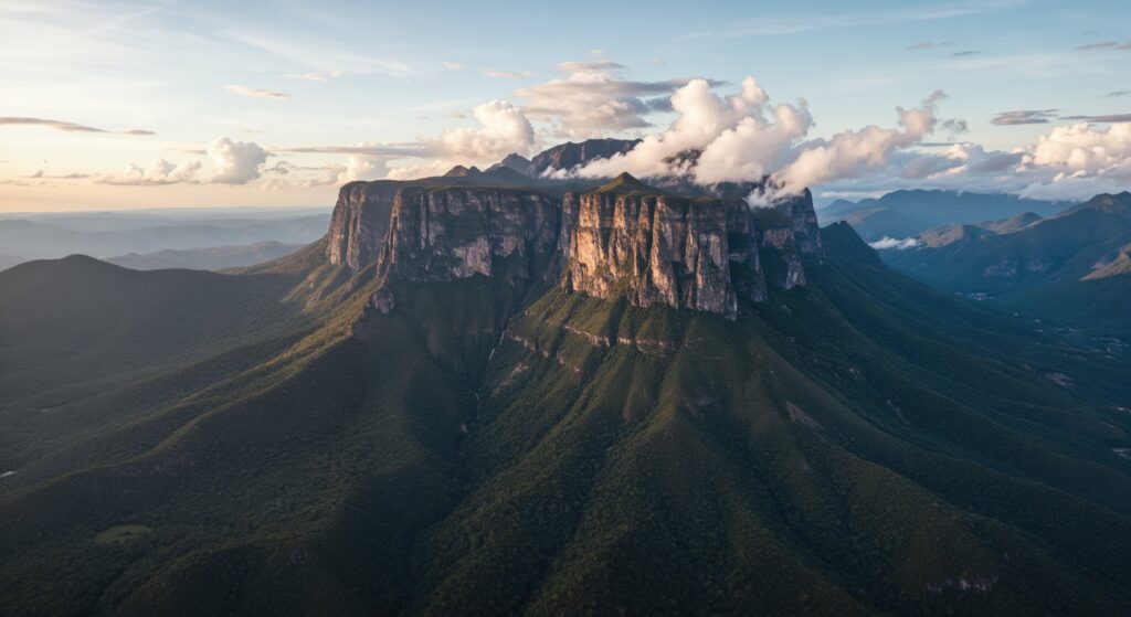
Mount Roraima is one of South America’s most famous tepuis and one of the most visually unique trekking destinations in the world. Rising at the border of Venezuela, Guyana, and Brazil, it is known for its sheer cliffs, flat summit plateau, strange rock formations, endemic plant life, and the multi-day trek required to reach the top. This page covers the classic trekking route, plateau experience, access planning, season notes, essential gear, safety considerations, featured videos, and guide companies for planning a Mount Roraima expedition.
Mount Roraima Quick Facts
| Category | Details |
|---|---|
| Countries | Venezuela, Guyana, and Brazil |
| Region | Pacaraima Mountains / Guiana Highlands |
| Elevation | 2,810 m / 9,220 ft |
| Status | One of the most famous tepuis in South America |
| Mountain type | Flat-topped tepui / tabletop plateau |
| Visitor style | Multi-day trekking expedition with plateau exploration rather than a technical summit climb |
| Typical duration | Usually 5–8 days depending on route pace and time spent on top |
| Primary risks | Heavy rain, muddy trails, stream crossings, long trekking days, exposure on the plateau, and underestimating wet conditions |
Main Routes (Overview)
Route #1: Classic Venezuelan Trek Route
- Theme: the standard and most popular way to reach Mount Roraima.
- Best for: trekkers wanting the classic multi-day Roraima experience.
- Character: long approach days across savanna and foothills followed by the natural ramp that gives access to the top.
- Important note: this is a real trekking expedition, not a short day hike.
Route #2: Paraitepui to Base Camp Progression
- Theme: the classic expedition flow most guided teams follow.
- Best for: visitors who want to understand how the trek is usually structured.
- Character: start from the indigenous village area, hike to camps below the mountain, then ascend to the plateau.
- Note: the route is not highly technical, but the distance, mud, and weather make it demanding.
Route #3: Plateau Exploration Days
- Theme: what makes Roraima so different from a normal summit trek.
- Best for: trekkers who want to experience the top beyond simply “reaching it.”
- Character: exploring rock labyrinths, viewpoints, pools, crystal areas, and the tri-border zone on the plateau.
Route #4: Mount Roraima as a Lost World Trek
- Theme: the mountain’s identity as a geological and ecological world apart.
- Best for: travelers seeking one of the most unusual landscapes in South America.
- Character: a trekking journey focused as much on the summit plateau environment as on the ascent itself.
Why Mount Roraima is so different
- It is not a pointed summit but a giant tabletop world of cliffs, stone gardens, and plateau exploration.
- The real reward is often the time spent on top, not simply the climb up.
- Its geology, endemic species, and “lost world” atmosphere make it unlike almost any other trekking destination.
Access & Logistics
What to know before you go
- The classic trekking access is usually from the Venezuelan side.
- Most teams begin from the Paraitepui area and follow a multi-day route to the base and plateau.
- Roraima is commonly done with guides, pack support, and established camp progression.
- Wet conditions are often the single biggest logistical factor.
Typical expedition rhythm
- Travel to the trailhead area and begin the savanna approach.
- Camp below the mountain and continue toward the access ramp.
- Climb onto the plateau and explore the top.
- Descend and retrace the trekking route back out.
Planning notes
- Expect wet shoes, muddy trails, and rain exposure even in favorable periods.
- Plateau camps and route progress are weather-sensitive.
- Extra days on the itinerary can improve both comfort and summit-plateau enjoyment.
Best Time to Visit (Season Window)
| Season | Typical Conditions | Pros | Watch-outs |
|---|---|---|---|
| Drier season windows | Usually the preferred trekking period with somewhat more manageable trail conditions | Better visibility, less rain pressure, and smoother camp logistics | Roraima can still be wet, cloudy, and cold on top |
| Rainier periods | More frequent rain, heavier mud, and more difficult stream crossings | Dramatic waterfalls and lush scenery | Harder trekking, more soaked gear, and less plateau visibility |
Season planning tip
For Mount Roraima, the best season usually means trying to reduce rain exposure rather than expecting truly dry mountain conditions.
Essential Gear Checklist
Trekking essentials
- Reliable rain protection for both body and pack
- Trail footwear that can handle mud, water, and slippery rock
- Quick-drying clothing and warm layers for the plateau
- Water protection for electronics and sleeping gear
Plateau additions
- Extra insulation for cold, wet summit nights
- Good camp organization for persistent moisture
- Headlamp and spare batteries
- Foot care items because wet conditions are common throughout the trek
Most underestimated factor
The biggest mistake on Mount Roraima is underestimating how wet the trek can feel. Even though the route is not a technical summit climb, mud, rain, soaked gear, and long trekking days can wear people down quickly.
Difficulty & Safety Notes
What makes Mount Roraima challenging
- Rain and mud: the trek is often much wetter than people expect.
- Long days: the route requires real trekking endurance.
- Plateau exposure: the top can be cold, windy, and confusing in poor visibility.
- Stream crossings: these can become more difficult after heavy rain.
- False expectations: the route is non-technical for most trekkers, but it is still a serious multi-day mountain expedition.
Featured Videos (Mount Roraima)
Mount Roraima: Watch & Learn
These videos help visualize the trek, the approach landscape, and the unique summit plateau environment.
Find Hotels, Flights & Trips for the World’s Best Hiking Destinations
The Global Summit Guide Travel Shop on Expedia — curated for outdoor adventurers, mountaineers, and serious hikers. Patagonia to the Alps. Nepal to the Rockies. Curated lodging for every region we cover.
Explore Travel Shop on Expedia →Watch on YouTube
Watch on YouTube
Watch on YouTube
Featured Mount Roraima Guide Companies
Below are three guide or expedition companies you can feature for Mount Roraima trekking and Lost World-style expeditions.
Nahua Expeditions
A regional operator offering Roraima trekking expeditions and broader indigenous-lands adventure programming.
Osprey Expeditions
Guided Mount Roraima trekking support with expedition pacing, route logistics, and plateau experience planning.
Redfern Adventures
Adventure operator focused on Mount Roraima’s iconic multi-day Lost World trekking experience.
Frequently Asked Questions
Is Mount Roraima a technical climb?
No for the classic trek. Most visitors reach the plateau by hiking the standard route rather than technical climbing.
How many days does Mount Roraima take?
Most expeditions take several days, often around 5–8 days depending on the itinerary and how much time is spent exploring the plateau.
Why is Mount Roraima so famous?
It is famous for its sheer cliffs, flat summit plateau, tri-border location, strange rock landscapes, and Lost World atmosphere.
What is the biggest challenge on Mount Roraima?
The biggest challenges are usually persistent wet conditions, muddy trekking, and the physical demands of a multi-day approach.
Related Peaks
More Tepui & South America Objectives
Useful additions to your South America and unique-landscape internal link structure.
Map of Mount Roraima
View the summit location, route area, current weather, and 5-day mountain forecast.
Was this helpful?
🏔Related peaks nearby
🧭Explore & compare
Global Summit Guide is an independent mountaineering resource founded in 2026. The team combines first-hand trekking and climbing experience with in-depth research and professional health and nutrition review to help climbers choose objectives, prepare properly, and stay safe.
Health, altitude, and nutrition content is reviewed by Taylor Ludlow (Registered Nurse) and Brigg Hoopes (Nutritionist).
What We Don't Know Yet
Mountain information changes quickly. This box explains the limits of what this page can responsibly promise.
- Weather, snowpack, avalanche risk, road access, and route conditions can change quickly and may be different on your climbing dates.
- Route conditions, trailhead access, crevasse exposure, stream crossings, and rescue access may vary from published planning guidance.
- Gear requirements can change by season, route variation, weather window, personal cold tolerance, and guide-service requirements.
- Fitness and altitude response vary by person; no guide, itinerary, or training plan can guarantee acclimatization or summit success.
- Visa, passport, vaccination, border, insurance, and local transportation rules may change before your trip.
Verify current conditions with official land managers, guide services, local forecasts, and current route reports before booking or climbing.
Part of this Global Summit Guide cluster
Explore the complete Mountains guide for more context, routes, planning links, and related resources.
Mountaineering, rock and ice climbing, glacier travel, and high-altitude activity are inherently dangerous and can result in serious injury or death. The information on Global Summit Guide is provided for general informational and educational purposes only and is not a substitute for professional instruction, qualified guiding, proper equipment, or your own judgment and experience.
Route conditions, weather, snowpack, permits, regulations, and hazards change constantly and may differ from what is described here. Details may be incomplete, out of date, or contain errors. Always verify current information with local authorities, certified guides, and official sources before making any decision in the mountains.
Nothing on this site is medical, legal, or financial advice. Our fitness, acclimatization, altitude, and nutrition content is general in nature; consult a qualified physician before beginning any strenuous exercise program or exposing yourself to high altitude.
You are solely responsible for your own safety and decisions. To the fullest extent permitted by law, Global Summit Guide and its team accept no liability for any loss, injury, damage, or expense arising from use of, or reliance on, this information. By using this site you acknowledge these risks and accept these terms.
Some links on this site may be affiliate links. If you buy through them we may earn a small commission at no extra cost to you; this never affects our recommendations.
Global Summit Guide recommendation path
Next Best Mountain to Research
Use these recommendations to continue the right planning path instead of stopping on one page.
Use current permit, weather, route, and operator information before booking or climbing.