web analytics

Search results for: “”

  • 15 Most Famous Mountains in the World

    Global Summit Guide · 15 Iconic Peaks

    15 Most Famous Mountains in the World

    Discover the mountains that define adventure, geography and culture: Everest, Fuji, the Matterhorn, Kilimanjaro, K2 and ten more unforgettable summits.

    Explore real mountain photography from the Global Summit Guide library, compare their heights and locations, and discover which peaks are hiking objectives and which require advanced mountaineering.

    15 Famous mountains
    7 Continents represented
    500 Peaks in GSG directory
    Quick Answer

    What Are the World’s Most Famous Mountains?

    Mount Everest, Mount Fuji, the Matterhorn and Kilimanjaro are among the most recognizable mountains on Earth. K2, Mont Blanc, Denali, Aconcagua and Mount Rainier are also globally important for mountaineering and geography.

    This is an editorial ranking based on recognition, distinctive appearance, cultural importance and climbing history. It is not a survey-based popularity ranking.

    #MountainLocationElevation
    1EverestNepal / China8,848.86 m
    2FujiJapan3,776 m
    3MatterhornSwitzerland / Italy4,478 m
    4KilimanjaroTanzania5,895 m
    5K2Pakistan / China8,611 m
    6Mont BlancFrance / ItalyAbout 4,806 m
    7DenaliAlaska, USA6,190 m
    8AconcaguaArgentina6,961 m
    9RainierWashington, USA4,392 m
    10ElbrusRussia5,642 m
    11WhitneyCalifornia, USA4,421 m
    12Aoraki / Mount CookNew Zealand3,724 m
    13Table MountainSouth AfricaAbout 1,086 m
    14OlympusGreece2,918 m
    15Vinson MassifAntarctica4,892 m
    Important: Fame, summit elevation and climbing difficulty are different things. A mountain may be famous because of its shape, history, religious significance or national identity, rather than its height.
    01 Asia · Himalaya

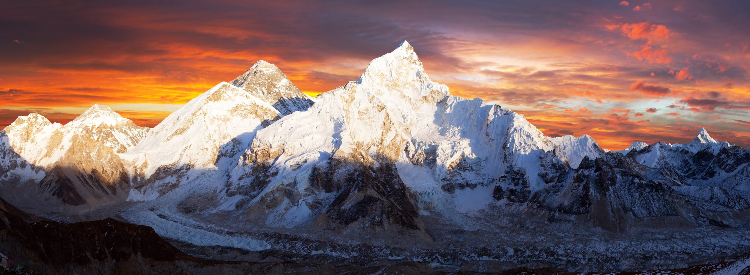
    Mount Everest

    8,848.86 mNepal / China

    The world’s highest summit above sea level is perhaps the most universally recognized mountain. Everest became an icon of mountaineering following the 1953 ascent by Edmund Hillary and Tenzing Norgay.

    The standard commercial routes still require prolonged acclimatization, technical preparation and extreme-altitude support. The mountain’s international reputation should not obscure its very real hazards.

    Mount Everest at sunset in the Himalaya
    Mount Everest · GSG WordPress media library
    02 Asia · Japan

    Mount Fuji

    3,776 mJapan

    Fuji’s nearly symmetrical volcanic cone has shaped Japanese art and culture for centuries. Its snow-capped outline makes it recognizable even to people who have never visited Japan.

    The official climbing season offers established summit routes, but weather, altitude, overnight logistics and current access rules all require planning.

    Mount Fuji and the Chureito Pagoda landscape in Japan
    Mount Fuji · GSG WordPress media library
    03 Europe · Alps

    Matterhorn

    4,478 mSwitzerland / Italy

    The Matterhorn’s dramatic pyramid rises above Zermatt and Cervinia. Its outline has become a visual shorthand for the European Alps.

    The 1865 first ascent cemented its place in mountaineering history. Modern standard routes still demand confident movement on exposed rock, route-finding and technical judgment.

    Matterhorn reflected in Riffelsee in the Swiss Alps
    Matterhorn · GSG WordPress media library
    04 Africa · Tanzania

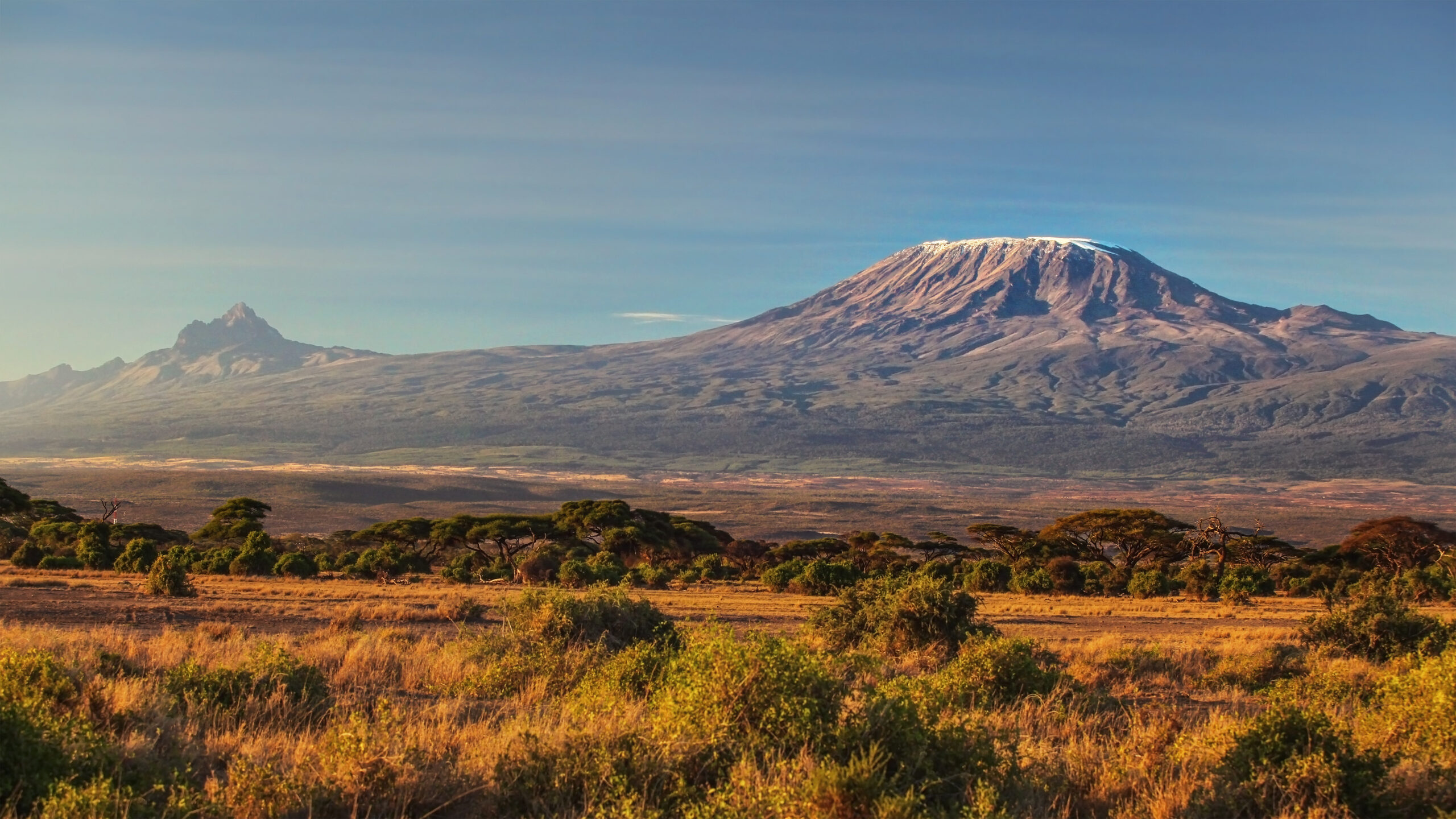
    Mount Kilimanjaro

    5,895 mTanzania

    Kilimanjaro is Africa’s highest mountain and one of the Seven Summits. Its broad volcanic massif rises above East African plains and has become an international trekking landmark.

    Standard summit routes are generally nontechnical, but altitude, cold temperatures and itinerary length make acclimatization central to success.

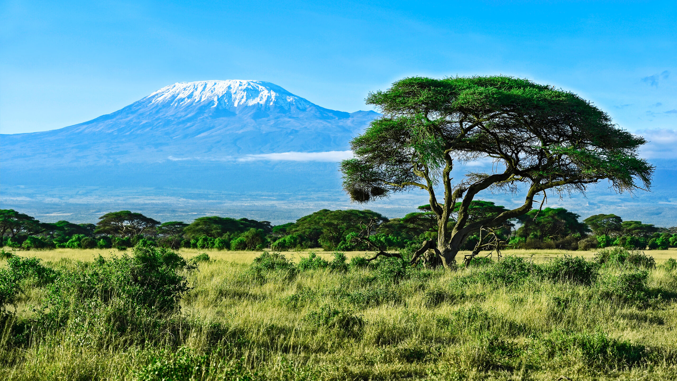
    Mount Kilimanjaro rising above the Amboseli landscape in Kenya
    Kilimanjaro viewed from Kenya · GSG media library
    05 Asia · Karakoram

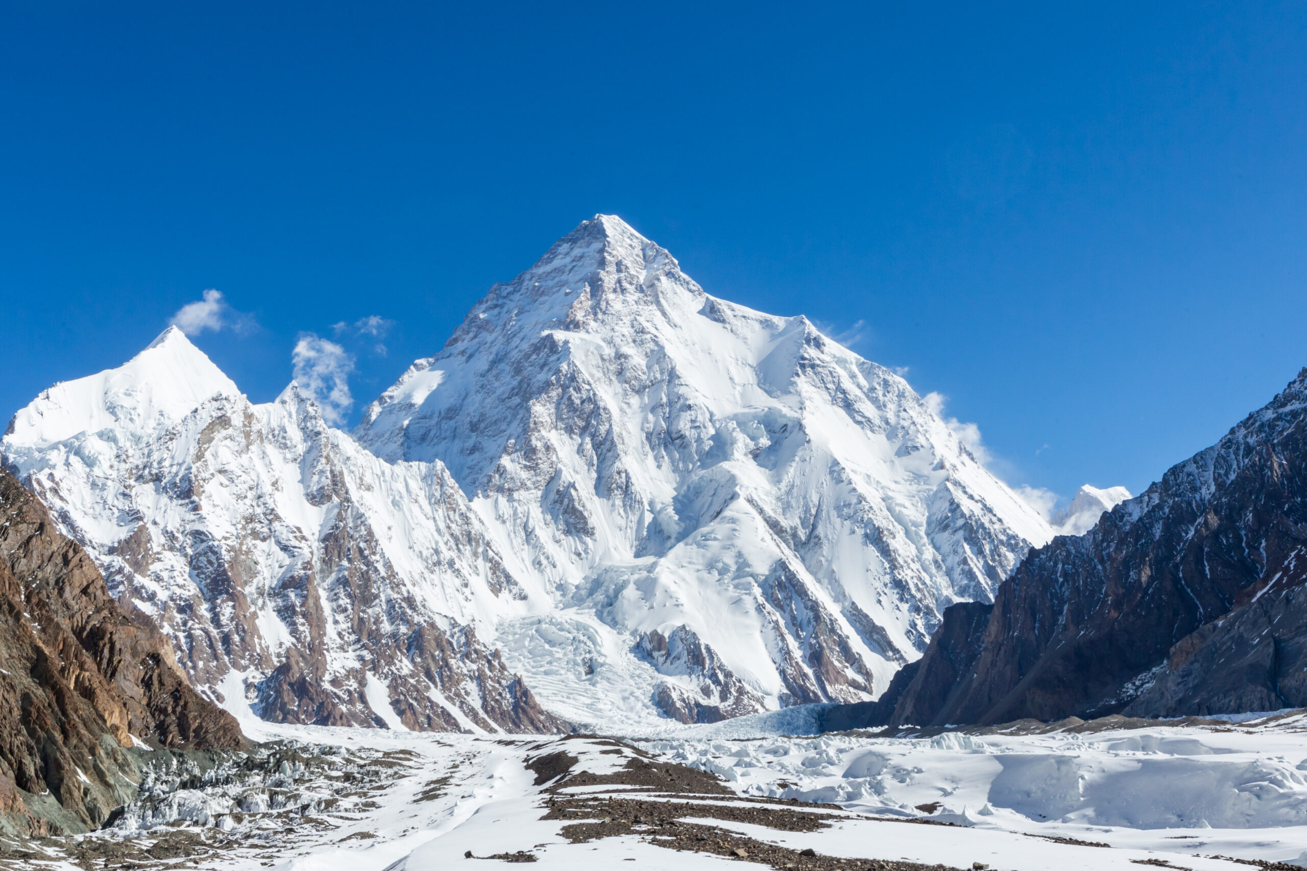
    K2

    8,611 mPakistan / China

    K2 is Earth’s second-highest mountain, known for its steep ridges, formidable technical climbing and remote setting. The Karakoram summit is one of the defining objectives of high-altitude mountaineering.

    Its commonly used routes combine extreme altitude with consequential technical and objective hazards. K2 is not a beginner expedition.

    K2 mountain rising above the Karakoram range
    K2 · GSG WordPress media library
    06 Europe · Alps

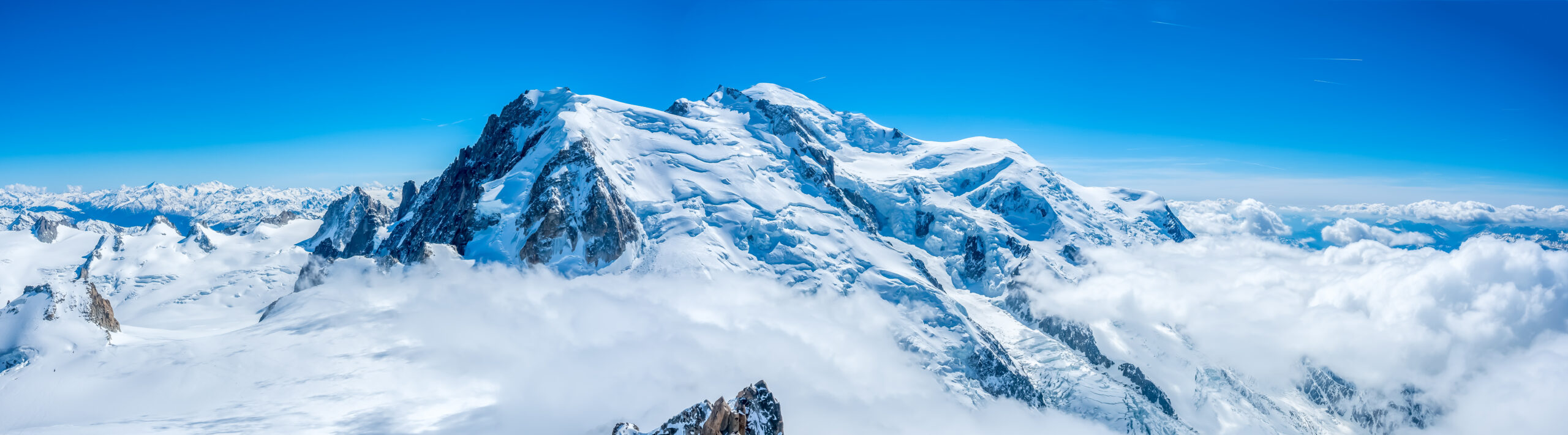
    Mont Blanc

    About 4,806 mFrance / Italy

    Mont Blanc is the highest mountain in the Alps and a foundational location in European alpinism. Its 1786 first ascent is a defining milestone in mountaineering history.

    The standard routes involve snow and glacier travel, acclimatization, rockfall or other route hazards, and careful hut and access planning.

    Mont Blanc mountain in the French Alps
    Mont Blanc · GSG WordPress media library
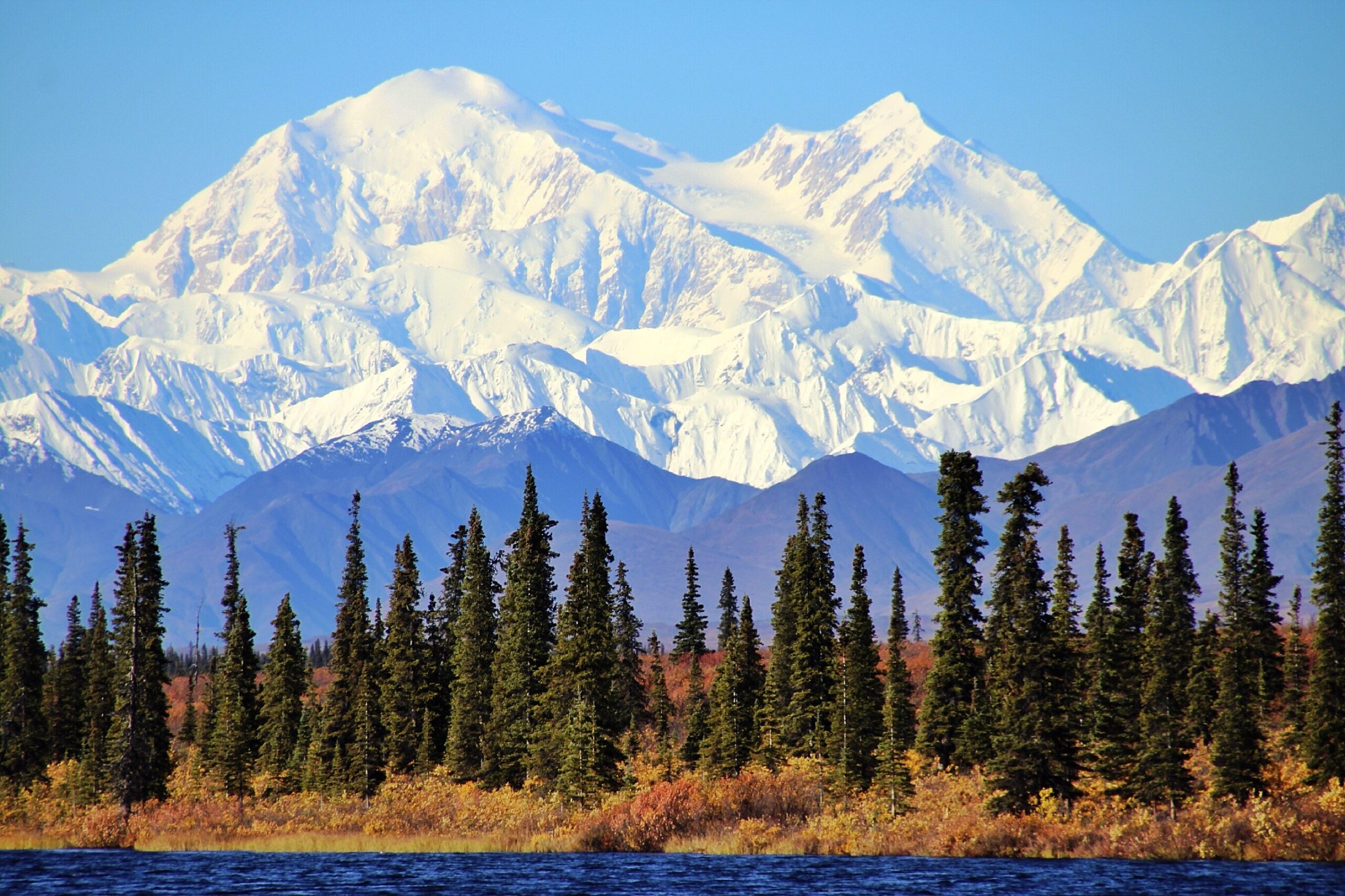
    07 North America · Alaska

    Denali

    6,190 mUnited States

    Denali is North America’s highest mountain, famous for its immense vertical presence above the Alaska Range and its severe expedition conditions.

    The West Buttress combines glacier travel, expedition camping, load hauling, cold management and challenging weather windows.

    Denali rising above the Alaska wilderness
    Denali · GSG WordPress media library
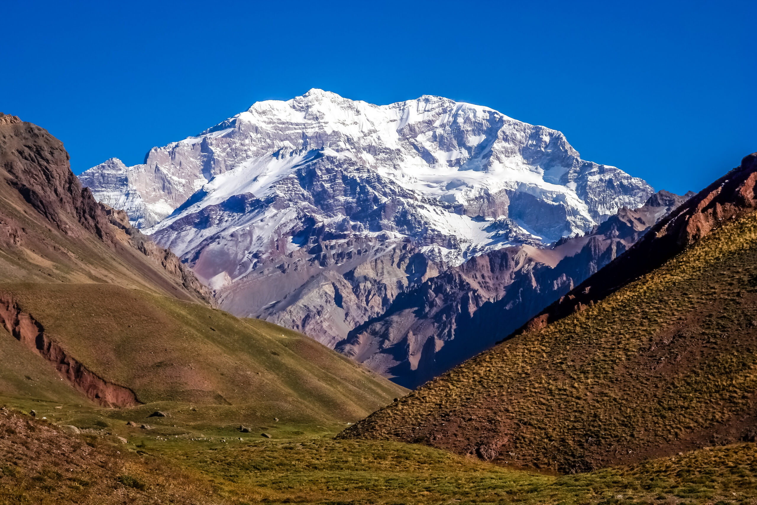
    08 South America · Andes

    Aconcagua

    6,961 mArgentina

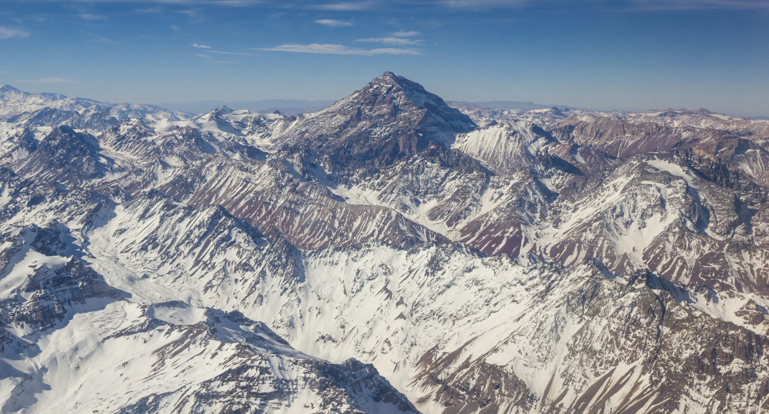
    Aconcagua is the highest summit in the Americas and the highest mountain outside Asia. Its high-Andes setting and Seven Summits status make it one of the world’s major mountaineering objectives.

    Its Normal Route is often considered nontechnical under favorable conditions, but the altitude, weather and expedition workload remain substantial.

    Aconcagua mountain summit in the Andes of Argentina
    Aconcagua · GSG WordPress media library
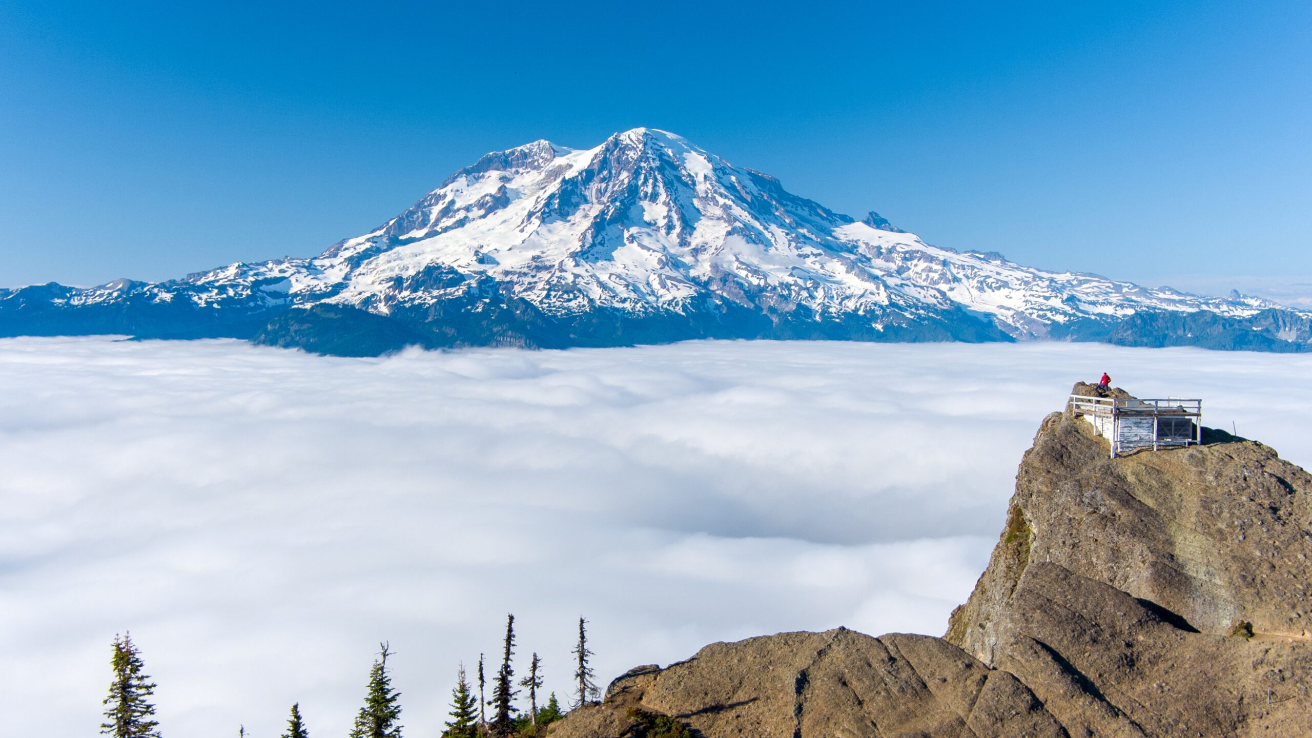
    09 North America · Cascades

    Mount Rainier

    4,392 mWashington, USA

    Rainier is a defining visual landmark of the Pacific Northwest. The heavily glaciated volcano dominates the skyline and is a well-known training ground for alpine climbers.

    Its standard summit routes require mountaineering equipment, technical glacier travel and sound decisions about weather and crevasse hazards.

    Mount Rainier as seen from High Rock Lookout in Washington
    Mount Rainier · GSG WordPress media library
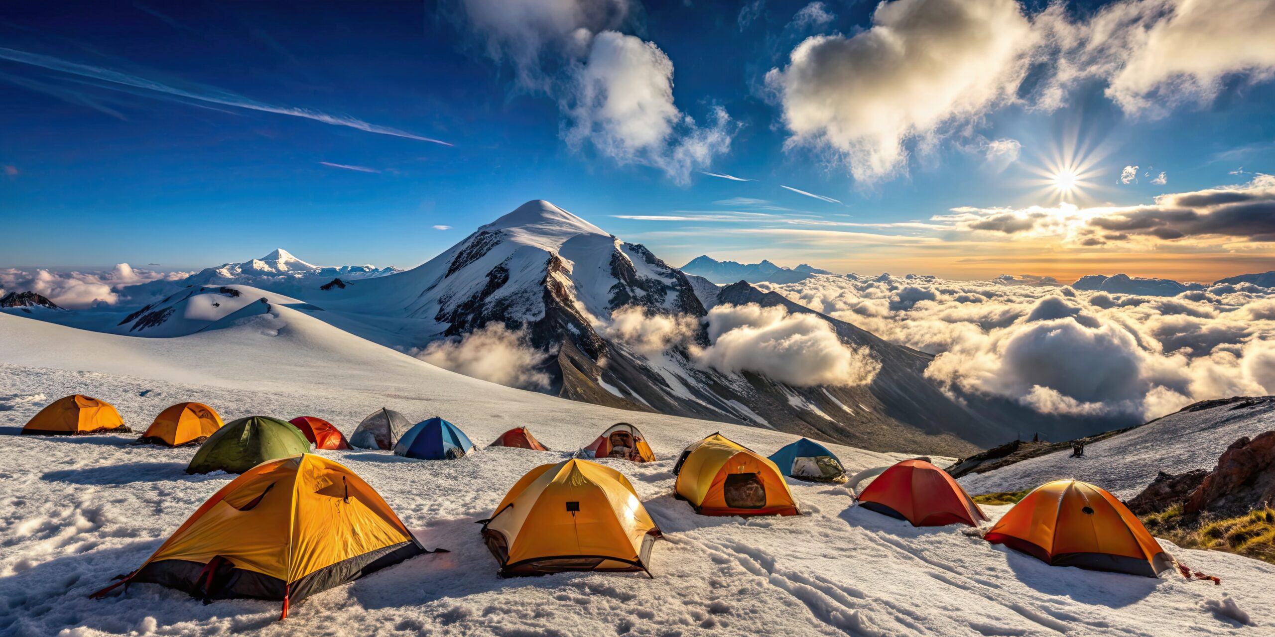
    10 Caucasus · Russia

    Mount Elbrus

    5,642 mRussia

    The twin-summited volcano is commonly considered Europe’s highest mountain in Seven Summits lists. Its geographic distinction makes Elbrus globally recognized among highpoint climbers.

    The common routes involve snow travel, severe weather exposure, altitude and mountain-specific access challenges.

    Expedition camp on the northern route of Mount Elbrus
    Mount Elbrus expedition setting · GSG media library
    11 North America · Sierra Nevada

    Mount Whitney

    4,421 mCalifornia, USA

    The highest mountain in the contiguous United States is a celebrated long-distance hiking summit with striking views above the eastern Sierra Nevada.

    The standard trail is nontechnical in suitable dry conditions, but altitude, distance, permits and seasonal snow can complicate the climb.

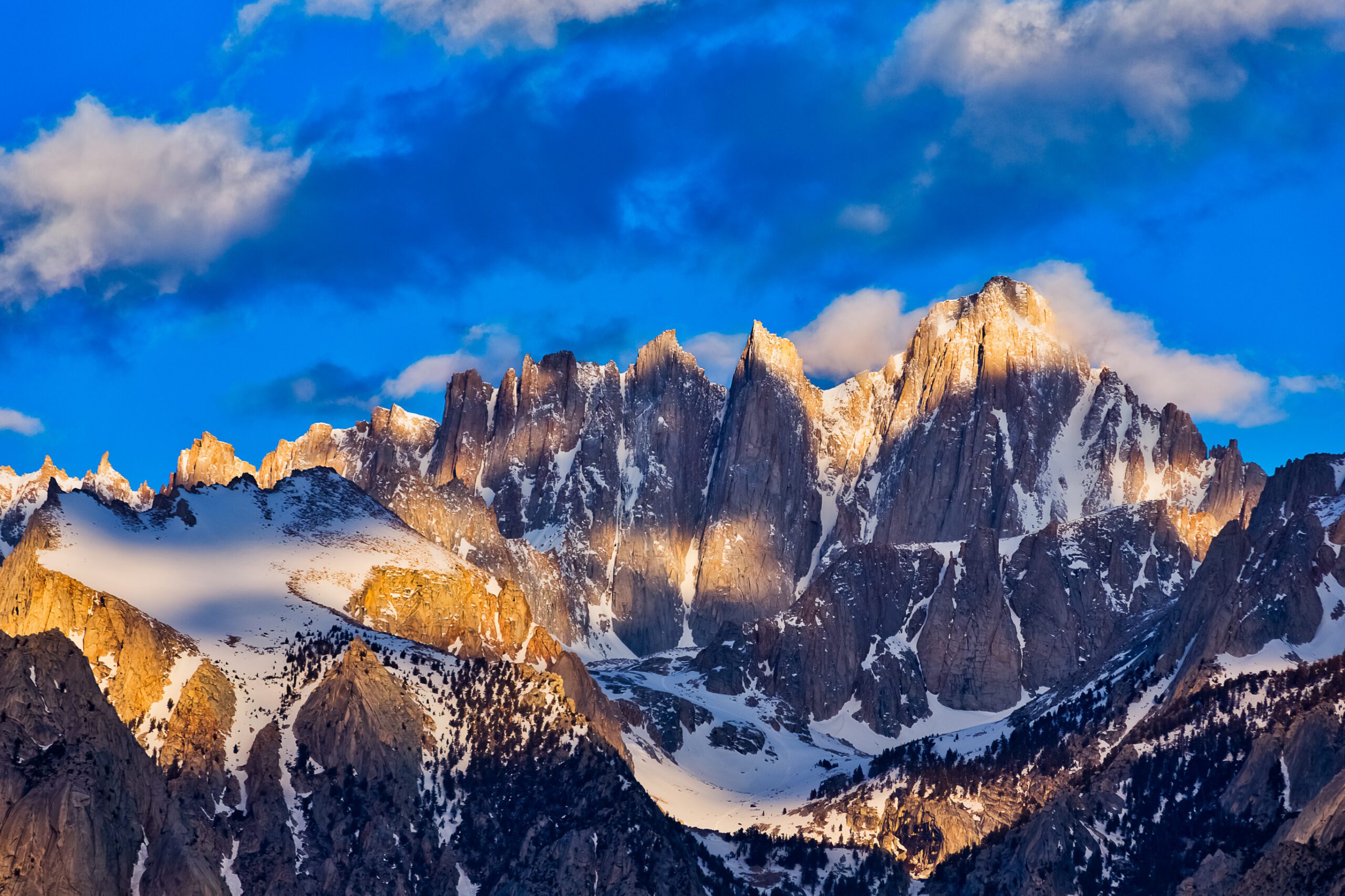
    Mount Whitney at sunrise in California
    Mount Whitney · GSG WordPress media library
    12 Oceania · New Zealand

    Aoraki / Mount Cook

    3,724 mNew Zealand

    Aoraki / Mount Cook is New Zealand’s highest mountain and a landmark of the Southern Alps. It is culturally important to Ngāi Tahu and central to the country’s technical alpine climbing history.

    Its summit routes demand strong glacier and alpine skills, experienced judgment and careful attention to unstable mountain conditions.

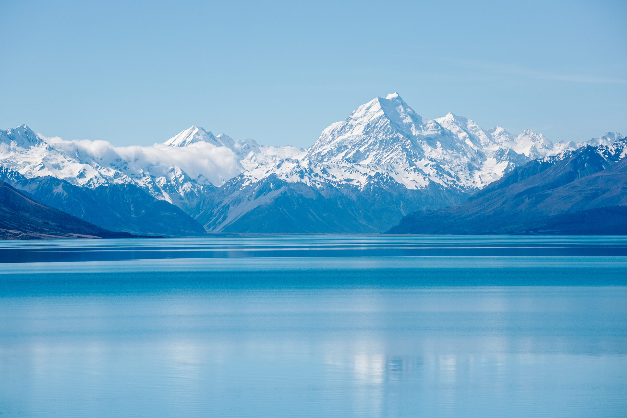
    Aoraki Mount Cook viewed across Lake Pukaki in New Zealand
    Aoraki / Mount Cook · GSG media library
    13 Africa · South Africa

    Table Mountain

    About 1,086 mCape Town

    Table Mountain’s distinctive flat profile dominates Cape Town and is one of Africa’s most recognizable landmarks. Its location makes it a celebrated destination for hikers and sightseers.

    Visitors can use different hiking routes or the cableway, subject to current operation, weather and access conditions.

    Table Mountain overlooking Cape Town South Africa
    Table Mountain · GSG WordPress media library
    14 Europe · Greece

    Mount Olympus

    2,918 mGreece

    Olympus is legendary as the mythological home of the ancient Greek gods. Its cultural fame extends well beyond the world of mountain climbing.

    Routes across the massif range from hiking to exposed scrambling. The highest summit, Mytikas, is a more serious objective than the lower trails.

    Panoramic view of Mount Olympus mountains in Greece
    Mount Olympus · GSG WordPress media library
    15 Antarctica · Ellsworth Mountains

    Mount Vinson

    4,892 mAntarctica

    Vinson Massif contains Antarctica’s highest summit. It is one of the Seven Summits and is famous for its remote polar setting.

    An expedition to Vinson involves specialized Antarctic logistics, severe weather preparedness, remote camping and significant travel and expedition costs.

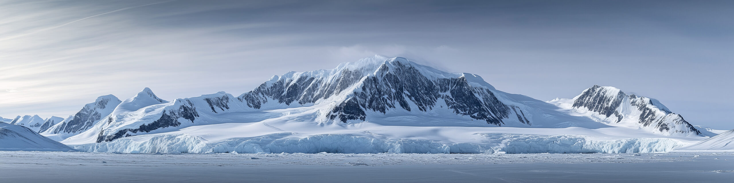
    Panoramic view of Vinson Massif in Antarctica
    Vinson Massif · GSG WordPress media library
    From Inspiration to a Mountain Plan

    Which Famous Mountains Can You Actually Climb?

    Famous mountains offer very different experiences. Some have scenic hiking trails; others require technical mountaineering or multi-week expeditions.

    Scenic Mountain Visits

    Fuji, Table Mountain, Olympus and the European Alps all offer ways to experience a mountain without attempting its most difficult summit route.

    Serious Trekking Summits

    Kilimanjaro, Whitney and Aconcagua have nontechnical standard routes in suitable conditions, but still demand preparation and careful judgment.

    Technical Expeditions

    Everest, K2, Denali, Matterhorn and Rainier involve specialized skills or extreme expedition challenges.

    Editorial methodology: Ranking order reflects our judgment of cultural significance, global recognition, distinctive appearance, geographic interest and climbing history. It is not an independently measured popularity index. Mountain-specific conditions and access rules must be checked before travel.
    Famous Mountains FAQ

    Questions About the World’s Most Recognizable Mountains

    What is the most famous mountain in the world?

    Mount Everest is a strong candidate because it is the highest mountain above sea level and internationally recognized for its climbing history. No official worldwide ranking of mountain fame exists.

    What is Japan’s most famous mountain?

    Mount Fuji is Japan’s highest summit and a widely recognized cultural symbol, known for its volcanic shape and long history in Japanese art.

    Which famous mountains are part of the Seven Summits?

    The mountains in this selection that belong to commonly used Seven Summits lists include Everest, Kilimanjaro, Denali, Aconcagua, Elbrus and Vinson. The Australia/Oceania summit convention determines the remaining member.

    Are the most famous mountains also the hardest to climb?

    No. Fame and elevation are separate from climbing difficulty. The specific route, season, exposure, weather and required skills determine the nature of a climb.

    Can beginners visit these mountains?

    Yes. Several have suitable visitor areas or hiking routes, but visiting a mountain does not imply its summit is suitable for beginners. Research the exact route and local restrictions.

    Discover Your Next Mountain

    Explore 500 Mountains Around the World.

    From the famous Seven Summits to lesser-known alpine peaks, Global Summit Guide helps you discover mountain objectives, compare difficulty and plan your next adventure.
    Was this helpful?

    Yes
    No
    Thanks for your feedback!
  • Operator Sponsorship Policy | Global Summit Guide

    Aconcagua expedition landscape in the Argentine Andes
    Global Summit Guide · Operator Advertising Standards

    Operator Sponsorship Policy: Visibility Without Influence.

    Understand how expedition operators can sponsor Global Summit Guide while our independent assessments, company rankings and recommendations remain protected from commercial influence.

    12-month agreements Clearly labeled advertising Independent rankings No guaranteed leads or bookings
    Our Core Rule

    Sponsorship Buys Advertising, Not a Recommendation.

    Global Summit Guide publishes independent mountain-specific operator comparisons, expedition company research and practical guidance for climbers planning major mountain objectives.

    Legitimate guiding companies can purchase clearly disclosed promotional visibility in designated advertising placements.

    Paid advertising does not influence a company’s position in an operator ranking, its editorial score, our pros and cons, or our final recommendation.

    Operators can also submit information for independent editorial consideration without paying any fee.

    Himalayan expedition terrain where climbers compare guiding companies
    Independent operator research and paid promotional placements serve separate purposes.
    Editorial Independence
    You can buy visibility on Global Summit Guide. You cannot buy our ranking.
    This commitment applies to all operator comparisons, company reviews and sponsored placements.
    12

    Month Term

    Standard fixed-term sponsorship.

    01

    Clear Label

    Visible Sponsored Operator disclosure.

    0

    Paid Rankings

    No purchased scores or recommendations.

    100%

    Editorial Control

    Final rankings remain independent.

    Sponsorship Terms

    Fixed Annual Terms. Clearly Defined Commitments.

    Our standard model is a 12-month placement. Exact destinations, deliverables, payment and dates are specified in an individual written agreement.

    Flagship Sponsorship Offer

    Sponsored Operator

    $2,400

    Proposed annual Kilimanjaro package

    A 12-month mountain-specific advertising placement with a clearly labeled sponsored card.

    Typical Package Inclusions

    • One contracted destination placement
    • Sponsored company card and clear disclosure
    • Approved logo or company image
    • Approximately 125-word company introduction
    • Website or inquiry CTA
    • Fixed twelve-month campaign period
    • Contractual statement of the agreed deliverables

    Pricing for Everest, Denali, Aconcagua, Mont Blanc or multiple destinations may differ. Availability and final fees must be confirmed before contracting.

    SubjectPolicy
    Campaign length Standard 12-month term with exact start and end dates in the agreement.
    Placement Designated promotional area of the contracted mountain or operator page.
    Disclosure Every paid placement marked Sponsored Operator or equivalent unambiguous advertising language.
    Link attributes Paid outbound links use rel=”sponsored nofollow”.
    Creative Approved text, logo, imagery and CTA as specified in the agreement.
    Editorial rankings Not included and never available for purchase.
    Exclusivity Not presumed. Any exclusive rights must be expressly stated in the agreement.
    Payment terms Amount, due dates and payment conditions are specified in writing before activation.
    Cancellation Termination and cancellation terms belong in the signed agreement.
    Refunds Any refundable amounts, nonrefundable charges or remedies must be documented in the agreement.
    Renewal Requires a new agreement or expressly agreed renewal. No lifetime placements.
    Performance No guaranteed traffic, impressions, leads, bookings, search position or expedition results.
    Written agreement governs commercial terms. This public policy does not itself create a booking, payment obligation, automatic renewal, cancellation penalty or refund entitlement. Every campaign requires agreed commercial terms. Editorial rankings remain outside the scope of every agreement.
    Mount Kilimanjaro, flagship destination for the initial operator sponsorship offering
    Kilimanjaro is the initial proposed flagship sponsorship market.
    Destination Relevance

    Advertising Should Match the Mountain.

    Readers comparing Kilimanjaro operators are evaluating different guiding needs from visitors researching Everest or technical alpine climbs.

    We prefer relevant mountain-specific placements over generic promotional material unrelated to the reader’s immediate research.

    The destination, page position, approved content and campaign dates should be identified in the agreement before publication.

    Editorial Integrity

    Independent Rankings Are Not Part of Any Sponsorship Contract.

    Global Summit Guide retains final authority over operator research, company assessments, rank order and recommendations. No advertising client can override that authority.

    Permitted Sponsorship Benefits

    Advertising Visibility

    • Clearly identified sponsored placement
    • Company logo and factual introduction
    • Relevant destination promotion
    • Direct website or inquiry CTA
    • Defined placement and contract term
    Never for Sale

    Editorial Influence

    • First place in an operator ranking
    • A higher assessment score
    • Guaranteed positive coverage
    • Removal of legitimate criticism
    • Guaranteed inclusion in a comparison
    • Protection against future ranking changes
    Equal treatment: Sponsors may independently earn editorial inclusion under the same criteria as non-sponsors. They can also be ranked lower or excluded when the available evidence warrants it.
    Advertiser Acceptance

    Every Sponsored Placement Must Meet Basic Quality Standards.

    Sponsorship inquiries are reviewed for relevance, legitimacy, factual accuracy and reader trust. Payment alone does not guarantee approval.

    01

    Company Identity

    We may verify the advertiser’s official identity, location and authority to offer its services.

    02

    Destination Relevance

    The company should offer relevant guiding, expedition or support services for the advertised destination.

    03

    Accurate Claims

    Claims about guides, services, prices, success rates and safety cannot be knowingly misleading.

    04

    Media Permissions

    Sponsors must be authorized to provide the logos, images and other creative they submit.

    05

    Transparent Presentation

    Advertising must not mimic editorial ranking badges, website navigation or independent safety endorsements.

    06

    Publisher Review

    Global Summit Guide retains the right to reject or request revisions to unsuitable advertising.

    Promotional Copy Must Remain Factual.

    Sponsors may describe their guiding programs, operating regions, departure models and verifiable credentials.

    Claims such as “the safest Everest company” or “the world’s best mountain operator” should not be used without adequate substantiation.

    We may edit sponsor text for accuracy, clarity, length and format. Promotional copy may not falsely imply that Global Summit Guide endorses the operator because it paid for visibility.

    Mont Blanc alpine climbing environment with professional mountain guiding considerations
    Professional guiding credentials and program details must be presented accurately.
    Mountaineer in high-altitude terrain demonstrating the importance of expedition operator research
    Illustrative expedition photography, not identified as a CTSS expedition.
    Editorial Example

    Our CTSS Everest Recommendation Is an Editorial Decision.

    Global Summit Guide currently places Climbing the Seven Summits (CTSS) at number one in our Everest operator comparison.

    We have personally met with CTSS representatives and reviewed substantial material about the company, its leadership and expedition programs.

    That research supports our current assessment. It is distinct from personally joining a CTSS Everest expedition, which we do not claim.

    Editorial position cannot be purchased. Our Everest rankings can change if the evidence changes, regardless of any company’s commercial relationship with Global Summit Guide.

    Research transparency: Direct meetings and detailed document review can inform our editorial analysis, but an operator’s access to our research team does not guarantee favorable coverage.
    Campaign Administration

    Changes, Compliance, Expiration and Renewal

    Sponsorship arrangements require clear procedures through the full term, including factual updates and the campaign’s scheduled end.

    Factual Updates

    Sponsors may request corrections to business details, contact links and approved creative. Updates remain subject to publisher review.

    Changed Services

    Sponsors should notify us of significant changes to the destinations, programs or services being advertised.

    Advertising Compliance

    Materially misleading claims or contractual violations may require changes, suspension or other actions under the signed agreement.

    Renewal

    A placement is not permanent. Renewal requires a new agreement or an expressly agreed process.

    Cancellation and refunds: The parties should agree in writing before payment on cancellation conditions, nonperformance remedies, any refund method and responsibility for approved advertising assets.
    Application Process

    How a Sponsored Operator Placement Begins

    01

    Inquire

    Provide company details and desired mountain markets.

    02

    Review

    We check suitability, destination relevance and inventory.

    03

    Agree

    Both parties approve scope, creative, price and dates.

    04

    Publish

    The labeled advertising appears for the agreed contract term.

    Frequently Asked Questions

    Operator Sponsorship FAQs

    Can an operator pay to become number one?

    No. Ranking positions, scores, verdicts and independent recommendations are not for sale. Sponsors purchase separately labeled advertising visibility.

    How long does sponsorship last?

    The standard package runs for twelve months. Exact campaign dates are stated in the signed agreement.

    How much does a sponsored listing cost?

    Our proposed flagship Kilimanjaro package is $2,400 per twelve-month term. Other destinations and multi-placement packages require individual quotes.

    How will readers know a placement is paid?

    Every paid operator card will carry a visible Sponsored Operator label or an equally clear disclosure and appear separately from rankings.

    Can a sponsor also appear in editorial rankings?

    Yes, but only when it independently meets the same editorial inclusion and assessment standards as non-sponsors.

    Does sponsorship guarantee website traffic or bookings?

    No. We do not guarantee impressions, traffic, leads, bookings, search rankings or climbing outcomes.

    Can an operator submit information for free?

    Yes. Any operator may provide relevant factual information for independent editorial consideration without a fee. Submission does not guarantee inclusion.

    Can a sponsor require changes to an unfavorable review?

    No. Sponsors cannot control editorial conclusions. Specific factual corrections can be submitted with appropriate evidence.

    Is the placement permanent?

    No. Sponsorships are fixed-term advertising products. We do not offer lifetime placements.

    Can sponsors renew?

    Yes, subject to agreement, available inventory, applicable terms and continued suitability.

    What happens if a sponsorship ends early?

    Early termination, refunds and related remedies are governed by the individual signed agreement.

    Was this helpful?

    Yes
    No
    Thanks for your feedback!
  • How We Rank Mountain Expedition Operators | GSG

    Denali and Alaska Range expedition landscape illustrating professional mountain guiding and operator assessment
    Global Summit Guide · Editorial Standards

    How We Evaluate and Rank Mountaineering Operators.

    Our independent approach to researching expedition companies: the evidence we review, the eight criteria that matter, how mountain-specific rankings are formed, and why companies cannot purchase a recommendation.

    Direct operator engagement Documented research Mountain-specific analysis No paid editorial rankings
    The Direct Answer

    Our Rankings Are Editorial Judgments, Not Advertising Positions.

    Global Summit Guide evaluates mountain expedition operators using the quality and relevance of available evidence. We consider guide qualifications, support structure, acclimatization, safety systems, local-staff welfare, decision-making, pricing transparency and contract terms.

    The evidence may include direct conversations and meetings with operators, substantial document review, publicly accessible records, official regulations, and firsthand climbing experience when available.

    We do not sell ranking positions. An operator may submit information for free or purchase separately disclosed sponsored visibility, but commercial payment cannot determine an editorial score, recommendation or ranking.

    Climbers navigating alpine terrain where guide decisions and risk management matter
    Comparing expedition operators requires more than price lists or promotional summit photographs.
    01

    Evidence First

    Claims are evaluated according to their source, date, specificity and verifiability.

    02

    Mountain Specific

    An excellent local guide and a global expedition operator can excel in different settings.

    03

    Explain Uncertainty

    Missing prices, unpublished staff details and operator-reported results are identified as such.

    04

    No Paid Rankings

    Advertising visibility is separate from reviews, scores, rankings and editorial conclusions.

    Research Quality

    What Counts as Evidence?

    Different operator pages have different depths of evidence. A direct meeting is not a completed expedition, and a company’s own summit numbers are not automatically independent statistics.

    Evidence Type A

    Firsthand Expedition Experience

    Experience actually climbing or traveling with an operator. We identify the mountain, trip, participant and scope of experience when making a firsthand claim.

    Evidence Type B

    Direct Operator Engagement

    Meetings, interviews and substantive discussions with company representatives or leadership. We may question staffing, operating decisions, program design and safety systems.

    Evidence Type C

    Documents and Primary Sources

    Program guides, published rates, itineraries, named guide credentials, official authorizations, expedition reports and relevant official records.

    Evidence Type D

    Independent External Records

    Government authorities, mountaineering organizations, public expedition databases, documented incident reporting and sources that can be independently checked.

    Evidence Type E

    Operator-Reported Information

    Company claims about summit outcomes, safety, staffing or experience. Useful context, but attributed and not presented as independently audited without verification.

    Evidence Type F

    Client Reports and Testimonials

    Accounts may provide clues about communication and program delivery. Individual anecdotes are not statistically representative and require appropriate caution.

    Research disclosure standard: Where material to our conclusion, the comparison should tell readers whether we personally climbed with the company, met its representatives, examined company-supplied materials, or relied on independent external sources. These are distinct kinds of evidence.
    Aconcagua mountain terrain illustrating how expedition logistics and operator expertise depend on location
    Operator competence and program quality must be assessed in the context of the actual mountain and route.
    The Strength of a Claim

    Specific Evidence Beats Marketing Language.

    “Experienced guides” is less informative than the names, qualifications and relevant route experience of the guides scheduled to lead a trip.

    “Excellent summit success” is less informative than a defined time period, number of clients attempting, number reaching the summit and a clear explanation of how outcomes are counted.

    We prefer identifiable, dated and comparable evidence. When material information is not available, we say so rather than assigning invented figures.

    Eight-Part Editorial Framework

    The Criteria We Use to Evaluate Operators

    These eight dimensions build on our existing operator-selection framework. Their relevance varies by mountain, route and climbing model. A one-day alpine guide service is not evaluated as though it were a 60-day Everest expedition.

    01

    Guide Qualifications and Support Structure

    Named leaders, relevant training, route-specific experience, certifications where appropriate, real guide-to-client ratios and actual field staffing.

    Key question: Who will guide this climb, and what support will each client receive?

    02

    Oxygen, Equipment and Operational Logistics

    Technical equipment, camp systems, communications, transport, high-altitude support and oxygen policies on mountains where supplemental oxygen is relevant.

    Key question: What exactly is provided, by whom, and under which circumstances?

    03

    Acclimatization and Itinerary Realism

    Route schedules, acclimatization days, rest opportunities, flexibility and the realism of the itinerary for the intended climber.

    Key question: Does the trip design allow a realistic adaptation and contingency plan?

    04

    Local Staff Welfare and Operating Practices

    Treatment of porters, guides and high-altitude workers; appropriate equipment, responsibilities, working conditions and relevant labor protections.

    Key question: How does the company support the people delivering the expedition?

    05

    Weather Decisions and Summit-Day Culture

    Forecast use, contingency management, willingness to turn around, decision authority, communication and resistance to unsafe summit pressure.

    Key question: Who decides when the team turns around?

    06

    Safety, Medical and Rescue Planning

    Risk identification, emergency communications, medical resources, evacuation procedures, incident response and clarity about insurance and rescue limitations.

    Key question: What happens if a climber becomes sick, injured, separated or unable to continue?

    07

    Pricing, Inclusions and Program Transparency

    Usable pricing, specific support tiers, included and excluded services, optional expenses and realistic comparisons between equivalent expedition products.

    Key question: Are we comparing the same level of support at each company?

    08

    Contracts, Cancellation and Client Fit

    Refund policies, cancellation rules, weather delays, prerequisites, screening, client responsibilities and whether the program matches the climber’s actual experience.

    Key question: Are the contractual risks and required experience clear before payment?

    Context matters: Supplemental oxygen is central to many Everest programs but not a normal criterion for a short guided alpine route. Portering practices, legal authorizations, weather flexibility and rescue logistics also differ by country. We apply relevant criteria rather than forcing every operator into an identical product model.
    Ranking Transparency

    How Scores and Recommendation Orders Work

    A score is only useful if readers understand what was evaluated, when, and against which other companies. Numerical precision should not conceal missing information.

    Global Summit Guide has used mountain-specific scorecards, including the six-part evaluation currently published in the Everest comparison. Our broader operator-selection research describes eight recurring criteria. These frameworks overlap, but they are not identical scoring instruments.

    We will not retroactively describe every historical ranking as an identical eight-category mathematical score. Existing pages retain their stated methods until they are formally reassessed. Going forward, any numerical ranking should identify its categories, weighting or points, evidence date, and material unknowns.

    Assessment elementEditorial requirementWhat we avoid
    Comparison scopeDefine the mountain, route, trip model and companies assessed.Implying every company in the market was reviewed.
    Evidence dateShow when material program details were checked.Presenting old rates or staff assignments as current.
    Score modelDescribe the dimensions and numerical basis if a score is used.Unexplained decimal scores or fabricated precision.
    UnknownsMark unpublished information and request clarification where practical.Inventing a price, credential, ratio or rescue promise.
    Operator claimsClearly attribute self-reported success and safety information.Treating company marketing statistics as independently audited.
    Editorial verdictExplain why the leader fits the mountain and type of climber.Equating one recommendation with guaranteed safety.
    Commercial relationshipDisclose relevant sponsorship or referral relationships.Allowing payment to alter rankings or scores.
    Ranking versus certification: Our editorial recommendations are comparative judgments based on the evidence reviewed. They are not regulatory certifications, safety guarantees, insurance endorsements or predictions of a particular climber’s summit outcome.
    Everest region high mountain terrain illustrating Himalayan expedition research
    Everest-region photography for context. This is not presented as a CTSS expedition photograph.
    Editorial Example · Everest 2027

    Why CTSS Is Our Current #1 Everest Recommendation

    Global Summit Guide has personally met with representatives of Climbing the Seven Summits and reviewed substantial company and expedition material. That direct engagement contributes context beyond simply copying public operator descriptions.

    Our published Everest comparison places CTSS first for 2027 planning. The ranking considers the company’s differentiated support programs, detailed published prices and options, leadership depth, Nepali guide integration, and current Everest-specific reporting.

    We distinguish those meetings and document reviews from personally climbing Everest with CTSS. We do not claim firsthand CTSS Everest participation.

    This is a mountain-specific editorial recommendation, not a declaration that CTSS is the safest or most suitable operator for every Everest climber.

    Research and independence: Direct contact with a company may improve our understanding of its operations, but access to representatives does not itself earn a positive ranking. CTSS’s current Everest position should remain based on the published merits of the program and be revised if stronger evidence warrants a change. No operator can purchase that position.
    Fair Comparisons

    What We Do When Operators Are Difficult to Compare

    Expedition businesses publish information in different formats. A cheap logistics package should not be presented as equivalent to a privately guided premium expedition.

    01

    Compare Like With Like

    We distinguish guided, private-guided, logistics-only and other service tiers, rather than comparing entry prices alone.

    02

    Preserve Missing Data

    When prices or support details are unpublished, we mark them as unknown rather than guessing.

    03

    Account for Client Fit

    Technical experience, need for supervision, altitude history and preferred climbing style affect the recommendation.

    Summit Success Rates Require Context

    We look for the number of clients, a defined period, the treatment of unsuccessful attempts and whether the figures include guides or other staff.

    A selectively reported summit percentage is not a complete measure of safety. Climbers should also consider appropriate turnarounds, conservative decision-making, client screening and honest reporting.

    Even with strong evidence, mountains remain inherently hazardous. No published statistic can predict an individual expedition result.

    Denali mountain terrain illustrating the limits of comparisons across different climbing objectives
    Expedition duration, route hazards and operational support are different across mountain systems.
    Commercial and Editorial Separation

    You Can Buy Visibility. You Cannot Buy Our Ranking.

    Expedition operators may provide materials for editorial consideration at no cost. Eligible companies may also purchase fixed-term sponsored visibility. These are separate processes.

    Editorial Coverage

    Independently Determined

    Inclusion, review depth, scores, recommendation order, pros and cons, and final verdicts remain editorial decisions.

    Sending information does not guarantee a listing or positive assessment.

    Sponsored Visibility

    Separately Disclosed

    Paid promotional placements are explicitly labeled Sponsored Operator and visually separated from editorial ranking results.

    Sponsored outbound links use rel="sponsored nofollow".

    Same review standard for everyone: A sponsor can appear in an independent ranking only when it qualifies on editorial merit. A company cannot pay to improve its position, suppress a criticism, purchase a score, or gain an undeserved recommendation.
    Ongoing Accountability

    Rankings Can Change as Evidence Changes.

    A ranking should not become permanent simply because it was once published. Programs, guide teams, prices, operating records and available evidence can change by season.

    01

    Collect New Evidence

    Review material updates from operators and independent sources.

    02

    Check Material Facts

    Verify changed pricing, leadership, programs and relevant regulations.

    03

    Reassess Fairly

    Apply the page’s disclosed methodology to comparable programs.

    04

    Explain Changes

    Update material dates, verdicts and the reasons for meaningful changes.

    Review dates: Every operator page should disclose its latest substantive review when practical. A date stamp alone is not proof that every fact was recently verified. Readers must confirm current program terms directly before booking.
    Right to Submit Factual Corrections

    Operators Can Challenge Facts. They Cannot Control Verdicts.

    We welcome credible correction requests from operators, guides, clients and relevant authoritative sources.

    Please identify the exact page, the disputed statement, the proposed correction and the supporting evidence. Include a contact person who can answer follow-up questions.

    We assess corrections on their merits and update substantiated factual errors. A correction may also require reassessing a score or ranking when it materially changes the underlying evidence.

    A disagreement with our opinion is not automatically a factual error. Operators do not receive final editorial approval rights or guaranteed favorable coverage.

    Alpine mountain setting illustrating technical guiding and mountain-specific editorial assessment
    Technical alpine guiding and high-altitude expedition operations require different evidence.
    Send corrections to: info@globalsummitguide.com . Use the subject line “Operator Factual Correction” and include the URL and documentary support. Please do not send confidential customer records, medical information or private identity documents.
    Reader Trust

    Conflicts of Interest, Personal Relationships and Editorial Judgment

    A transparent research system must address relationships that could influence—or appear to influence—coverage.

    Information Access Is Not Payment

    An operator providing an interview, meeting, program guide, itinerary, biography or factual supporting document does not purchase editorial consideration or a positive result.

    Material Relationships Require Disclosure

    Relevant paid partnerships, affiliate arrangements, complimentary services or other material benefits must be disclosed as appropriate on affected content. Research access alone should not be misrepresented as firsthand travel.

    Claims of Personal Experience Must Be Accurate

    Meetings, research interviews and reviews of an operator’s materials are identified separately from participation in its expeditions. We do not claim personal climbs that did not occur.

    No Guaranteed Result From Sponsorship

    Commercial agreements may define a promotional placement, approved creative, destination and term, but cannot promise editorial ranking, Google position, leads or bookings.

    Frequently Asked Questions

    Questions About Our Operator Review Methodology

    How does Global Summit Guide rank mountain operators?

    We review relevant evidence and apply mountain-specific assessment criteria including qualifications, guiding support, logistics, acclimatization, staff welfare, summit decision-making, risk management, pricing transparency and contract terms. When a numerical score is used, the relevant comparison should explain it.

    Are all operators personally tested by Global Summit Guide?

    No. Our evidence varies by operator and page. It may involve personal expedition experience, direct meetings, document review and independent records. We distinguish these sources rather than presenting all research as firsthand climbing.

    Why is CTSS ranked number one for Everest?

    Our current Everest comparison places CTSS first for 2027 planning based on its documented support options, transparency, leadership and current Everest-specific research. Global Summit Guide has also personally met with CTSS representatives and reviewed substantial company material. See the Everest comparison for the detailed verdict.

    Can expedition companies pay for higher rankings?

    No. Editorial rankings, scores, pros and cons and verdicts are not for sale. Sponsorship buys separately disclosed promotional visibility.

    Can a company be reviewed without paying?

    Yes. Operators may submit company information for editorial consideration at no charge. Submission does not guarantee inclusion or a favorable assessment.

    Are summit success rates independently verified?

    Not automatically. Company-reported success figures are attributed unless an independent source specifically supports them. We look for timeframes, client denominators and clear outcome definitions.

    Do all operator pages use the same scoring formula?

    Not necessarily. Earlier mountain comparisons may use a six-category model or other stated mountain-specific methods. This page explains the broader eight-criteria research framework. Each page should disclose its own actual scoring method.

    Can an operator request a correction or reconsideration?

    Yes. Submit the page URL, disputed fact and supporting documentation. We review evidence independently and correct supported factual errors. Final rankings and opinions remain editorial decisions.

    Does a high ranking mean the expedition is safe?

    No. Mountaineering can involve serious injury, illness or death even with experienced guides. A ranking is not a guarantee of safety, summit success, rescue availability or individual suitability.

    Editorial Resources

    How to Verify an Operator Before Booking

    No directory can substitute for checking the actual contract, team, destination conditions, applicable authorizations and insurance provisions for your proposed expedition.

    Operator Comparison Directory

    Browse the mountain-specific comparisons and individual company research already published.

    Browse Operators →

    How to Choose an Operator

    Learn which questions to ask about staffing, safety, programs and costs before committing.

    Read the Selection Guide →

    Operator Submissions

    Companies can provide current information, request factual corrections or ask about separately disclosed sponsorships.

    Submit Company Information →
    Editorial policy publication: October 9, 2026. This page states the methodology and disclosure standards Global Summit Guide intends to apply to new and updated operator research. It does not retroactively certify that every historical comparison used the same formula.
    Independent Mountain Research

    Choose the Mountain. Evaluate the Evidence. Find the Right Team.

    A good operator comparison should help you understand who is guiding, what the expedition actually includes, how risks are managed, what remains unknown and which program best matches your experience.

    Our responsibility is to make those distinctions clearer—while keeping editorial recommendations independent from sponsored advertising.

    Was this helpful?

    Yes
    No
    Thanks for your feedback!
  • Get Listed on Global Summit Guide | Operator Sponsorship

    Professional mountaineer assessing expedition conditions in a high mountain environment
    For Expedition Operators · Global Summit Guide

    Get Your Expedition Company in Front of Serious Climbers.

    Global Summit Guide researches mountain guiding companies, compares real expedition programs and helps climbers make informed decisions. Operators can submit company information for independent editorial consideration or request a separate, clearly disclosed sponsored placement.

    Free editorial submissions Independent rankings 12-month sponsorships Mountain-specific audience
    Two Ways to Participate

    Share Your Expertise. Or Sponsor Visibility. Never Buy a Ranking.

    Both opportunities are available, but they serve different purposes. Information supplied by operators can improve independent research. Sponsored placements give companies clearly identified advertising visibility.

    Path 01 · Editorial

    Free Operator Submission

    $0 Submission fee

    Submit current information about your company, expedition leadership, mountain programs, technical credentials, safety practices and pricing.

    Our research team may use this information to evaluate your company for an existing operator comparison, an individual profile or future coverage.

    • Company and leadership information
    • Mountains, routes and departure programs
    • Guide credentials and safety systems
    • Current program pricing and inclusions
    • Opportunity to provide factual corrections
    No guaranteed inclusion. Submission does not buy publication, a positive review or a particular ranking position.
    Path 02 · Commercial

    Sponsored Operator Placement

    $2,400 / year · flagship destination package

    Purchase a dedicated, clearly labeled promotional placement near relevant destination and operator research. The package is designed for qualified companies seeking visibility among climbers evaluating real expeditions.

    • Promotional card clearly labeled Sponsored Operator
    • Company logo or approved photograph
    • Approximately 125-word company introduction
    • Website and inquiry contact pathway
    • Defined mountain-specific placement
    • Fixed 12-month term
    Visibility, not endorsement. Paid sponsorship never changes editorial scores, ordering, pros and cons or recommendations.

    The $2,400 annual package is the proposed flagship Kilimanjaro sponsorship offering. Pricing for other mountains, inventory and deliverables are confirmed individually before a contract is issued.

    Real Research · Not Pay-to-Play

    Our Operator Reviews Are Built Around Evidence and Experience.

    An operator comparison should give climbers confidence that we have seriously examined the company and its programs—not simply collected marketing descriptions or accepted a payment.

    Global Summit Guide uses several forms of research depending on the operator and the mountain: direct meetings with company representatives, substantial review of company materials, program comparisons, published expedition records, official requirements and documented firsthand climbing experience when available.

    Direct interaction matters. Meetings with operator leadership can help us ask detailed questions about staffing, emergency procedures, logistics, cost structures and the actual experience climbers should expect.

    We distinguish those meetings and research activities from personally climbing with an operator. Where we have firsthand expedition experience, we identify it. Where our assessment relies on interviews, documents or published records, we explain that evidence as well.

    High Himalayan climbing terrain representing expedition operator research
    Our assessment considers the real operational demands of each mountain. Image illustrates the terrain, not a specific operator’s expedition.
    01

    Direct Engagement

    Meetings and substantive discussions with operator representatives or leadership, with the source and scope identified where relevant.

    02

    Documented Research

    Expedition itineraries, program specifications, prices, guide biographies, reports and independently checkable materials.

    03

    Firsthand Experience

    Actual experience traveling or climbing with a company, when available, identified separately from interviews and desk research.

    Mount Everest region illustrating the demands of Himalayan expedition operations
    Everest operator rankings are based on mountain-specific research. This is illustrative Everest-region photography, not CTSS imagery.
    Example of an Editorial Recommendation

    Why We Currently Rank CTSS #1 for Everest

    Global Summit Guide has personally met with representatives of Climbing the Seven Summits (CTSS) and reviewed substantial information about the company, its leadership and its expedition programs.

    Our Everest editorial comparison places CTSS first for 2027 planning because of the combination of program transparency, differentiated support levels, experienced international and Nepali leadership, current Everest operating information and recent results reporting.

    This is our current independent editorial assessment—not a paid position or a claim that CTSS is the safest or best fit for every individual climber.

    Reviewing a company through meetings, documents and other evidence does not mean we personally participated in its Everest expeditions. The distinction matters.

    Our non-negotiable editorial rule: An operator can be ranked #1, #5, or not included at all based on our independent evaluation. Paying for advertising does not change any of those outcomes. Sponsorships are labeled and displayed separately from editorial rankings.
    Editorial Submission Requirements

    What We Ask Operators to Provide

    The more specific and verifiable your information, the more useful it is to our research. You do not need to be a large international expedition company. Qualified local specialists are welcome.

    01 · Business Identity

    Company Information

    Official name, business location, operating history, website, ownership, relevant registrations, licenses, contact person and destinations.

    02 · People

    Guides and Staff

    Names of expedition leaders, technical credentials, climbing and guiding experience, guide ratios, local guide leadership and staff responsibilities.

    03 · Programs

    Summits and Routes

    Mountains served, routes offered, itinerary lengths, acclimatization design, departures, experience prerequisites and expected client preparation.

    04 · Risk Management

    Safety and Rescue

    Risk-management approach, emergency communication, medical arrangements, rescue and evacuation protocols, insurance expectations and turnaround decisions.

    05 · Commercial Clarity

    Costs and Contracts

    Current program pricing, what is included or excluded, deposits, cancellation terms, refunds, weather contingencies, tips and optional costs.

    06 · Evidence

    Records and Media

    Expedition records, published results with clear denominators, staff welfare policies, relevant references, authorized photographs and logo usage.

    Evidence and confidentiality: Please identify information that is confidential. We may request clarification or supporting documents, but do not submit sensitive personal data, passport records, medical records or clients’ private information. Material submitted for consideration does not automatically become publishable content.
    The Editorial Path

    How a Free Operator Submission Is Reviewed

    01

    Submit

    Send company identity, destinations and supporting information.

    02

    Review

    We assess relevance, documentation and gaps in the existing research.

    03

    Verify

    We may request details, consult sources or interview company representatives.

    04

    Decide

    Editorial staff determine whether and how the company merits coverage.

    Editorial control: Operators may submit verifiable factual corrections. They cannot require positive wording, demand a ranking, approve the final verdict or remove documented criticism as a condition of participation.

    Learn how mountain-specific comparison research works in our guide to choosing an expedition operator .

    Operator Sponsorship Program

    Reach Climbers Researching Your Mountain.

    Sponsored visibility is a straightforward advertising product. A company buys clearly disclosed exposure in a relevant research environment—not a favorable editorial conclusion.

    Flagship Pilot Package

    Sponsored Operator

    $2,400

    Per 12-month term

    Initial Kilimanjaro-focused sponsorship package. Other mountain placements are individually quoted.

    What’s Included

    • A separately identified Sponsored Operator card on the contracted destination page.
    • Operator logo or one approved image.
    • Approximately 125 words of factual, sponsor-supplied company information, subject to editorial and advertising review.
    • A website link and contact CTA.
    • Defined placement and a fixed 12-month term.
    • Clearly stated sponsorship disclosure.
    • Placement and link checks during the contract term.

    Packages do not guarantee impressions, traffic, inquiries, bookings, summit success, Google rankings or a position in editorial rankings. Availability, start date and exact deliverables are confirmed in the written agreement.

    Advertising Standards

    What Operators Can Buy—and What They Cannot

    Commercial placements are valuable only when readers can clearly distinguish paid visibility from an independent editorial recommendation.

    Available for Purchase

    Sponsored Visibility

    • Clearly labeled promotional cards
    • Approved company imagery and descriptions
    • Relevant destination-page advertising
    • Direct inquiry and website links
    • Fixed-term promotional inventory
    Not Available for Purchase

    Editorial Influence

    • First place in an operator ranking
    • Higher methodology scores
    • Positive reviews or guaranteed endorsements
    • Removal of relevant editorial criticism
    • Guaranteed inclusion in independent shortlists
    Example sponsorship disclosure: “Sponsored Operator — This company has paid Global Summit Guide for promotional visibility. Sponsorship does not influence our editorial rankings, assessments or recommendations.”

    Sponsored outbound links use rel="sponsored nofollow". A sponsor can also appear in an independent comparison if it qualifies under the same research criteria used for every other operator.

    Andean expedition landscape illustrating destination-specific mountain guiding markets
    Mountain-specific sponsorships connect guiding companies with readers studying relevant destinations.
    Get Started

    Send Us Your Operator Information

    Choose the form matching your goal. Editorial submissions and commercial sponsorship inquiries are reviewed separately. You may use both paths.

    Free Editorial Submission

    Submit Your Company

    Help us research your guiding operation and consider your company for existing or future mountain comparison content.

    This button opens your email application with the information entered. You must send the resulting email yourself. No information is stored by this form. Prefer direct email? Write to the editorial team .

    Contact Global Summit Guide: info@globalsummitguide.com · 435-660-1797

    These are separate inquiries. Sending an editorial submission does not create an advertising agreement. Sending a sponsorship inquiry does not purchase a ranking, reserve inventory or guarantee approval.

    Operator Questions

    Frequently Asked Questions

    Does it cost anything to submit my company?

    No. Supplying factual information for independent editorial consideration is free. It does not guarantee an operator profile, inclusion in a comparison or any particular ranking.

    Can we pay to appear on a mountain operator page?

    Yes. Qualified companies may purchase clearly labeled sponsored promotional positions where advertising inventory is available. Such placements are not independent editorial recommendations and are kept separate from ranking tables.

    Can we pay to become the number-one recommended operator?

    No. Editorial rankings and scores are not for sale. Sponsorship does not influence research findings, ordering, verdicts, positive or negative assessments, or recommendations.

    How does Global Summit Guide research companies?

    Our process can include direct meetings with operators, detailed review of expedition and company materials, publicly available evidence, official records, operator responses to factual questions and firsthand climbing experience where available. The type and depth of evidence are identified in the relevant research.

    Why is CTSS currently ranked number one for Everest?

    Global Summit Guide has met with CTSS representatives and reviewed substantial company information. Our current 2027 Everest recommendation considers documented leadership, differentiated programs, pricing transparency, support models and Everest expedition reporting. CTSS did not purchase its editorial position. See our full Everest comparison for the assessment and methodology.

    Can a sponsored operator also appear in an independent ranking?

    Yes, but only if it independently qualifies under the same criteria as other operators. Sponsorship has no influence on that determination.

    How long does a sponsorship last?

    The standard proposed agreement runs for 12 months. The exact dates and deliverables are specified in writing. Sponsorships do not continue permanently.

    What does the $2,400 sponsorship include?

    The proposed flagship Kilimanjaro package includes a clearly labeled sponsored card, company imagery, a short factual description, direct website link and defined destination-page visibility for 12 months. Other destinations or multiple-page packages require individual quotes.

    Can we request a correction to an existing operator profile?

    Yes. Send a specific factual correction with a supporting source or document. We review factual corrections independently and retain final editorial control over conclusions and rankings.

    Are all submitted operators approved for sponsorship?

    No. Global Summit Guide reserves the right to decline advertising that is misleading, unverifiable, inappropriate for the destination or inconsistent with reader safety and trust.

    Explore Our Research

    See How Operators Are Compared

    Review examples of actual mountain-specific comparisons and company research before submitting your information or inquiring about sponsorship.

    Mountain Comparison

    Everest Operators

    Our editorial comparison ranks CTSS first for 2027 planning and explains the evidence supporting the current recommendation.

    View Everest Research →
    Mountain Comparison

    Kilimanjaro Operators

    Compare route programs, guide models, local crew considerations and commercial climbing options.

    View Kilimanjaro Research →
    Research Directory

    Mountaineering Operators

    Browse mountain-specific comparisons and individual operator profiles across the Global Summit Guide research library.

    Open the Operator Directory →
    Remote alpine mountain landscape representing international expedition partnerships
    Work With Global Summit Guide

    Help Climbers Understand Your Company. Reach the Right Audience.

    Whether you are a local mountain guide, a regional climbing company or an international Seven Summits operator, you can provide factual information for independent research. Qualified companies can also discuss paid promotional visibility.

    Our editorial judgments remain independent regardless of the commercial relationship.

    Was this helpful?

    Yes
    No
    Thanks for your feedback!
  • Camino Primitivo vs Camino del Norte (2027): Which Is Harder?

    Green countryside on the Camino Primitivo at Valduno in Asturias
    Home  ›  Pilgrimage Trails  ›  Pilgrimage Comparisons  ›  Camino Primitivo vs Camino del Norte
    Asturias · Atlantic Spain · Mountain Camino vs Long Coastal Camino · 2027

    Camino Primitivo vs Camino del Norte: Which Harder Camino Should You Walk?

    Choose the Camino Primitivo if you want a concentrated two-week pilgrimage where mountains, weather and the historic Original Way define the journey. Choose the Camino del Norte if you have five or six weeks and want a much longer Atlantic pilgrimage through the Basque Country, Cantabria, Asturias and Galicia with repeated hills, coastal scenery and more total endurance.

    ≈320 km vs ≈820–850 km 13–15 vs 34–40 days mountains vs coast Hospitales vs Atlantic rollers 2027 planning
    Already leaning one way? Open the Camino Primitivo guide or the Camino del Norte guide.
    The direct answer

    Primitivo Is Steeper. Norte Is the Bigger Endurance Test.

    Choose the Camino Primitivo when you want the harder route per day. Asturias gives it repeated climbing, mountain weather, long descents and the famous Hospitales decision. It is roughly 300–320 km from Oviedo and normally fits into about two weeks.

    Choose the Camino del Norte when you want the harder journey in total. From Irún it is roughly 820–850 km, normally takes five to six weeks, and repeats the same basic physical problem for more than a month: descend toward the sea, climb away from it, then do it again.

    If you ask only “Which has tougher mountain walking?”, the answer is generally Primitivo. If you ask “Which requires more endurance and life commitment?”, the answer is clearly Norte.

    ≈320 km Camino Primitivo · Oviedo → Santiago
    ≈820–850 km Camino del Norte · Irún → Santiago
    13–15 days typical full Primitivo
    34–40 days typical full Norte
    Two hard Caminos · two different definitions of hard

    Do Not Compare These Routes With One Difficulty Number.

    Both routes are routinely described as among the harder major Caminos. That is true—but incomplete.

    The Primitivo compresses its challenge. You leave Oviedo and quickly enter a route shaped by rural Asturias, repeated gradients, mountain weather and exposed choices such as Hospitales.

    The Norte spreads the challenge across an enormous distance. The Basque coast can be physically demanding immediately, Cantabria continues the rolling pattern, Asturias keeps it going and Galicia only arrives after weeks of accumulated mileage.

    That means a strong hill walker with two weeks may be happier on the Primitivo, while a less mountain-oriented walker with excellent long-distance endurance may prefer the Norte.

    Inside this comparison

    Decide Whether You Want Intensity or Duration.

    Then compare weather, lodging, crowds, scenery and how much flexibility you need.

    01 · Side by side

    Camino Primitivo vs Camino del Norte

    The Primitivo asks more from each mountain day. The Norte asks you to keep walking for several additional weeks.

    FactorCamino PrimitivoCamino del Norte
    Classic startOviedo.Irún.
    Approx. distance≈300–320 km.≈820–850 km.
    Typical time12–15 days.34–40 days.
    Core identityOldest route · rural · mountainous.Atlantic · coastal · long-form pilgrimage.
    Technical difficultyNon-technical walking.Non-technical walking.
    Main physical problemSteeper terrain, repeated climbing and mountain exposure.Repeated rolling terrain sustained for five to six weeks.
    Signature challengeHospitales decision and Asturian mountain rhythm.Basque opening + thousands of small Atlantic climbs.
    CoastNot a coastal Camino.One of the route’s defining attractions.
    Mountain feelStronger.Frequent hills rather than one sustained mountain identity.
    WeatherMountain fog, wind, rain and cold matter.Atlantic rain, humidity and wind repeat over a longer trip.
    2025 pilgrims27,873 · 5.25%.21,521 · 4.05%.
    Social feelSmall route community; friendships form quickly.More dispersed because walkers are spread across 800+ km.
    Lodging flexibilityGood enough, but bottlenecks matter in mountain sections.More uneven over the full route; tourist coast can complicate summer lodging.
    Best broad seasonJune and September; May and July can also work.June–September, with May a strong alternative.
    Merge with FrancésMelide.Arzúa.
    Best reason to chooseMountain challenge + Original Way history.Atlantic scenery + five-week pilgrimage depth.
    Harder per day

    Camino Primitivo

    Asturias puts more climbing, weather awareness and mountain consequence into a much shorter route.

    Harder in total

    Camino del Norte

    Five or six weeks of rolling coast creates a much larger endurance and recovery problem.

    Best for two weeks

    Camino Primitivo

    Few Caminos fit this much route identity and physical challenge into roughly fourteen days.

    Camino del Norte overlooking Zarautz and the Basque coast
    Camino del Norte · Basque coast

    The Norte Looks Coastal. Your Legs Experience It as Repeated Vertical.

    The route repeatedly drops toward beaches, harbors and estuaries before climbing back onto headlands and inland ridges. No single hill needs to be enormous for the accumulated effort to become substantial after several weeks.

    Camino del Norte near Zarautz · José Antonio Gil Martínez / Wikimedia Commons · CC BY 2.0.
    02 · Route character

    Primitivo Feels Ancient and Concentrated. Norte Feels Like a Long Atlantic Journey.

    Both eventually reach Santiago, but the weeks before that arrival tell very different stories.

    Camino Primitivo climbing through Monte da Curiscada in Asturias
    Camino Primitivo

    The Original Way With a Mountain Edge.

    The Primitivo is associated with Alfonso II and the earliest royal pilgrimage tradition to Santiago. That history matters because the route still feels less like a developed corridor and more like a line through country.

    Start Oviedo
    Signature choice Hospitales vs Pola
    Major city reset Lugo
    Francés merge Melide

    The route is short enough that its identity never becomes diluted. Asturias shapes the first half; Galicia softens the walking without erasing the rural character.

    Camino del Norte route approaching San Sebastian on Monte Ulia
    Camino del Norte

    Four Regions and More Than a Month Beside the Atlantic.

    The Norte begins at Irún and immediately moves through one of its physically strongest sections toward San Sebastián and Bilbao. Cantabria, Asturias and Galicia then keep changing the route.

    Start Irún
    Regions Basque · Cantabria · Asturias · Galicia
    Signature feature Atlantic coast
    Francés merge Arzúa

    Five weeks creates a deeper sense of progression. San Sebastián, Bilbao, Santander and the Asturian coast become chapters rather than individual stops.

    Still comparing all five major Camino routes? Step back to the route hub before choosing the hardest option simply because the scenery looks dramatic.
    Compare All Camino Routes →
    03 · Which is harder?

    The Answer Changes Depending on Whether You Measure Terrain or Time.

    This is the central question the page should answer better than generic Camino rankings.

    Difficulty measurePrimitivoNorte
    Harder daily terrainWinner. More consistently mountain-shaped.Rolling and tiring but usually less concentrated.
    Total distance≈320 km.≈820–850 km.
    Total trip fatigueHigh but compressed.Much greater.
    Exposed route decisionHospitales.No equivalent single signature high-route choice.
    Repeated coastal rollersNot defining.Defining.
    Mountain weather sensitivityGreater.Atlantic weather matters for much longer.
    Footwear durabilityImportant.More cumulative mileage.
    Mental enduranceTwo-week commitment.Five- to six-week commitment.
    Overall verdictHarder hiking route.Harder total pilgrimage.
    Neither route is technical mountaineering.

    “Hard” on the Camino means repeated walking effort, steep gradients, wet trail, weather exposure, recovery demands and less logistical forgiveness. You do not need ropes, crampons or alpine climbing skills.

    Open mountain terrain on the Camino Primitivo in Asturias
    Camino Primitivo · Asturias

    Hospitales Is a Weather Decision, Not a Badge of Honor.

    The high route after Borres is one of the iconic lines of the Primitivo. In clear, stable conditions it can be magnificent. In poor visibility, strong wind, storms or wintry conditions, the lower route through Pola de Allande can be the better choice.

    Camino Primitivo, Asturias · Simon Burchell / Wikimedia Commons · CC BY-SA 4.0.
    04 · Signature route decision

    Hospitales Is What the Norte Does Not Have: One Famous Tactical Choice.

    Norte difficulty accumulates. Primitivo difficulty occasionally asks you to make a specific terrain decision.

    Take Hospitales when

    The Weather Says Yes.

    • visibility is good
    • wind is manageable
    • storms are not forecast
    • you have sufficient food and water
    • your legs are recovering well
    Take Pola de Allande when

    The Conservative Choice Is Better.

    • fog removes visibility
    • strong wind is forecast
    • storms threaten exposed ground
    • you need more services
    • fatigue is changing the day’s risk
    Norte equivalent

    Pace Is the Tactical Decision.

    Norte rarely hinges on one celebrated mountain fork. The smarter decision is usually to control your first-week pace so the repeated climbs do not damage the next five weeks.

    05 · Crowds & route density

    The Primitivo Recorded More Pilgrims—but That Does Not Mean It Feels Busier.

    Route totals must be interpreted against distance.

    27,873 Primitivo · 2025 About 5.25% of the Pilgrim Office route total.
    21,521 Norte · 2025 About 4.05% of recorded pilgrims.
    ≈2.6× Norte distance Its pilgrims are distributed over far more kilometres and considerably more walking days.
    Primitivo can feel more social than the Norte even with a smaller route culture.

    The reason is compression. Similar groups move through a shorter two-week itinerary and tend to meet repeatedly at the same mountain towns and albergues. Norte pilgrims are dispersed across an enormous coast.

    Ancient Roman walls of Lugo on the Camino Primitivo
    Camino Primitivo · Lugo

    Lugo Gives the Primitivo a City Reset Without Breaking Its Identity.

    After the harder Asturian and eastern Galician stages, Lugo’s Roman walls, food and urban services create a natural place to rest before the final progression toward Melide and Santiago.

    Roman Walls of Lugo · Joseolgon / Wikimedia Commons · CC BY 4.0.
    06 · Season & weather

    The Norte Likes Summer More. The Primitivo Rewards a Stable Mountain Window.

    Both live in northern Spain. Their best-season logic is still different.

    PeriodCamino PrimitivoCamino del Norte
    AprilPossible, but mountain weather can be unsettled.Green and quiet, with substantial rain potential.
    MayStrong shoulder-season choice if conditions are settled.Strong alternative with cooler temperatures.
    JuneExcellent. Long daylight and improving mountain conditions.Excellent. Long daylight and comfortable Atlantic temperatures.
    JulyGood; still cooler than hotter inland Spanish routes.Excellent. One of the Norte’s strongest months.
    AugustGood but busier and warmer.Strong weather window, though coastal tourist demand affects lodging.
    SeptemberExcellent. Strong balance of temperature and services.Excellent. Warm but increasingly storm-prone later.
    OctoberBeautiful but wetter, cooler and less reliable in the mountains.Atmospheric but wetter with shorter days.
    WinterNot the normal choice for Hospitales-oriented planning.Possible only with substantial service and weather compromises.
    Summer heat does not punish these routes the way it can punish the Meseta.

    That is one reason both become attractive when July or August is your only available Camino window. The tradeoff is Atlantic rain and humidity: cooler does not mean dry.

    Atlantic coastline seen from the Camino del Norte
    The Norte advantage

    Five Weeks Lets the Coast Become More Than Scenery.

    A short coastal hike gives you viewpoints. The Norte gives you enough time to experience entire regions: Basque food and cities, Cantabrian estuaries, Asturian coast and cider culture, then the inland shift into Galicia.

    That longer duration is also the cost. Footwear problems, rain systems, lodging decisions, fatigue and ordinary bad days all have more time to accumulate.

    07 · Albergues & logistics

    Primitivo Has Fewer Options Per Mountain Stage. Norte Has More Weeks to Manage.

    Neither route has the endless fallback system of the Francés.

    Lodging factorCamino PrimitivoCamino del Norte
    Albergue systemGood, but mountain towns can create obvious bottlenecks.Established across the route but uneven over 800+ km.
    Private roomsAvailable in most logical towns.Widely available, especially in coastal tourism centers.
    Booking strategyBook constrained mountain stages, Lugo and Santiago.Book high-pressure coast/tourism areas; preserve flexibility elsewhere.
    Stage flexibilityModerate.Moderate overall, but varies significantly by region.
    Food servicesLonger rural gaps deserve planning.Excellent cities and food culture, but quiet stretches still exist.
    Luggage transferAvailable and useful selectively.Available, though not identical in every region.
    Summer tourism pressureMostly pilgrim-driven.Can come from beach tourism as well as pilgrims.
    Do you like these routes but want easier logistics? Compare them with the Francés and Portugués before accepting extra difficulty that does not actually improve your trip.
    Choose a Camino by Time & Difficulty →
    08 · Route scale

    Two Weeks of Intensity vs Five Weeks of Repetition.

    This is what the two itineraries actually ask from your calendar.

    Primitivo framework

    Oviedo → Santiago in 13–15 Days

    • Oviedo → Salas: settle into the route
    • Salas → Tineo → Borres: mountain identity builds
    • Hospitales / Pola → Berducedo: signature decision
    • Grandas → A Fonsagrada: continued serious terrain
    • A Fonsagrada → Lugo: Galicia begins to soften
    • Lugo → Melide: pastoral transition
    • Melide → Santiago: shared Francés finish

    The Primitivo often improves when you add one day rather than remove one. A slightly slower mountain itinerary creates more weather and recovery margin.

    Norte framework

    Irún → Santiago in About Five Weeks

    • Irún → Bilbao: demanding Basque opening
    • Bilbao → Santander: urban exits + coastal hills
    • Santander → Llanes: Cantabrian coast
    • Llanes → Avilés: Asturias
    • Avilés → Ribadeo: western Atlantic stretch
    • Ribadeo → Arzúa: inland Galicia
    • Arzúa → Santiago: shared Francés finish

    Norte pacing is a long-game problem. The first week should feel sustainable enough that you can repeat it four more times.

    09 · Gear

    Both Reward the Same Strategy: Light Pack, Excellent Feet, Real Rain Protection.

    Neither route needs technical mountaineering gear. Both punish poor footwear and unnecessary pack weight.

    Primitivo priorities

    Grip + Mountain-Weather Margin

    • proven trail footwear
    • trekking poles
    • reliable rain shell
    • light warm layer
    • dry storage
    • small weather margin for Hospitales
    Norte priorities

    Durability + Wet-Weather Repetition

    • footwear built for very high mileage
    • trekking poles for repeated descents
    • rain protection you can wear often
    • fast-drying clothing
    • blister system
    • low overall pack weight
    Do not bring

    Expedition Gear You Do Not Need.

    • no technical climbing equipment
    • no heavy backpacking boot by default
    • no wilderness kitchen
    • no duplicate wardrobes
    • no “just in case” weight without a clear use
    Affiliate disclosure: Global Summit Guide may earn a commission from qualifying purchases through some gear links at no additional cost to you. Affiliate relationships do not determine our Camino comparisons, difficulty ratings or recommendations.
    Footwear buying moment

    Choose Shoes for Wet Descents, Not Just Comfortable Pavement.

    Both routes mix road walking with dirt, roots and stone. Primitivo needs confidence on steeper mountain surfaces; Norte needs enough comfort and durability to repeat the system for more than 800 kilometres.

    We may earn a commission if you buy through these links, at no extra cost to you. Affiliate disclosure

    Camino Primitivo approaching Doriga in Asturias
    The mountain-route lesson

    A Lighter Pack Makes Every Climb Easier and Every Descent Kinder.

    The Primitivo makes pack weight obvious quickly. Norte eventually teaches the same lesson through repetition.

    A few unnecessary kilograms do not sound serious when standing in an airport. They feel different after twenty consecutive climbing days.

    Spend packing effort on reliable footwear, rain protection, a warm layer and foot care. Strip out duplicate town clothing and unnecessary equipment.

    Camino Primitivo near Doriga · Simon Burchell / Wikimedia Commons · CC BY-SA 4.0.
    Daily foot-care purchase

    Your Socks Work Harder Than Almost Anything Else in the Pack.

    Rotate a small number of reliable pairs, dry them whenever possible and treat recurring friction early. The Norte gives a small foot problem weeks to become a large one.

    10 · Geographic orientation

    Primitivo Cuts West Through the Mountains. Norte Follows the Atlantic Before Turning Inland.

    These are orientation maps rather than field-navigation tracks. Use current official route files for the actual walk.

    Camino Primitivo

    Oviedo → Lugo → Melide → Santiago

    Asturias provides the mountain core. Galicia gradually lowers the physical intensity before the Primitivo joins the Francés at Melide.

    Camino del Norte

    Irún → Atlantic Spain → Arzúa → Santiago

    The Northern Way crosses the Basque Country, Cantabria and Asturias before leaving the coast in Galicia and joining the Francés at Arzúa.

    11 · Decision guide

    Which Harder Camino Fits You?

    Time solves half the decision. The kind of difficulty you enjoy solves the rest.

    Choose Primitivo if

    You Want a Mountain Camino in Two Weeks.

    • You have roughly 13–15 days.
    • You enjoy repeated climbing.
    • You want the oldest main Camino tradition.
    • You like rural route character.
    • You are comfortable making weather decisions.
    • Hospitales is part of the attraction.
    Choose Norte if

    You Want the Long Atlantic Camino.

    • You have five or six weeks.
    • The coast is a primary reason to go.
    • You want Basque Country, Cantabria and Asturias.
    • You value food and regional variety.
    • You are comfortable with repeated rolling terrain.
    • You want a quieter long-form Camino.
    Choose another Camino if

    You Like the Idea More Than the Difficulty.

    • Portugués for roughly two weeks with gentler terrain.
    • Francés for maximum support and flexibility.
    • Inglés for a one-week Camino.
    • Portugués Coastal for Atlantic scenery with less commitment.
    • Do not choose difficulty simply for bragging rights.
    Primitivo wins

    When intensity matters most.

    Mountain characterPrimitivo
    Two-week fitPrimitivo
    Oldest route historyPrimitivo
    Harder individual hiking daysPrimitivo
    Concentrated route identityPrimitivo
    Norte wins

    When scale matters most.

    Atlantic sceneryNorte
    Regional varietyNorte
    Food cultureNorte
    Total endurance challengeNorte
    Five-week pilgrimage depthNorte
    Decision made? Stop comparing and move into the route page that owns stages, lodging, maps and current logistics.
    Build My Camino →
    Pilgrims arriving at Santiago de Compostela Cathedral
    One Cathedral · two very different roads

    Both Become Busier at the End—but at Different Merge Points.

    The Primitivo joins the Camino Francés at Melide. The Norte joins it later at Arzúa. After days or weeks of relative space, the sudden increase in pilgrims can feel like part of the arrival itself.

    Pilgrims arriving in Santiago · Jules Verne Times Two / Wikimedia Commons.
    Frequently asked questions

    Camino Primitivo vs Camino del Norte FAQ

    The questions that usually determine whether Oviedo or Irún should be your starting point.

    Which is harder, Camino Primitivo or Camino del Norte?

    Camino Primitivo is generally harder per walking day because it is more mountainous, steeper and more weather-sensitive. Camino del Norte is the bigger overall endurance challenge because it is roughly 820–850 km and takes five to six weeks.

    How long is the Camino Primitivo?

    A useful full-route planning figure is roughly 300–320 km from Oviedo to Santiago, normally walked in about 12–15 days. Galicia officially lists roughly 167–168 km from the regional entry depending on the recognized variant.

    How long is the Camino del Norte?

    A useful full-route planning range is roughly 820–850 km from Irún to Santiago. Most full-route pilgrims need approximately 34–40 days, depending on pace, rest days and local variants.

    Which route has more mountains?

    Camino Primitivo has the stronger mountain identity. Camino del Norte climbs constantly but much of that difficulty comes from repeated coastal hills rather than a continuous mountain corridor.

    What is the Hospitales Route?

    Hospitales is the exposed high-route option on the Camino Primitivo after Borres. In stable weather it is one of the route’s iconic stages. The lower route through Pola de Allande is the more conservative choice when wind, fog, storms or wintry conditions make the high line unwise.

    Which Camino is quieter?

    Both are much quieter than the Camino Francés. The Norte recorded fewer total pilgrims in 2025 and spreads them across more than 800 km, so it can feel especially spacious. The Primitivo has a smaller, more concentrated two-week community.

    Which route has better coastal scenery?

    Camino del Norte by a large margin. Atlantic scenery is one of its defining reasons to walk, especially through the Basque Country, Cantabria and Asturias. The Primitivo is primarily an inland mountain pilgrimage.

    Which Camino is better if I only have two weeks?

    Camino Primitivo is the much cleaner choice. A full Norte requires roughly five or six weeks, while Oviedo to Santiago fits naturally into approximately two weeks.

    Which route is better in July or August?

    Both can work well in midsummer because northern Spain is generally cooler than inland Camino regions. The Norte has a particularly strong midsummer argument, while the Primitivo still requires close attention to mountain storms and weather on exposed sections.

    Where does the Camino Primitivo join the Camino Francés?

    The Primitivo joins the Francés at Melide. From there the final stages through Arzúa and toward Santiago become much busier than the earlier Primitivo.

    Where does the Camino del Norte join the Camino Francés?

    The Camino del Norte joins the Francés at Arzúa, later than the Primitivo. That leaves only the final approach to Santiago inside the shared Francés pilgrim flow.

    Can both routes qualify for the Compostela?

    Yes. Walking either complete route easily exceeds the general distance requirement. Pilgrims seeking the traditional Compostela must still follow the current Pilgrim Office rules for continuous qualifying distance, credential stamps and pilgrimage purpose.

    Which route would Global Summit Guide recommend first?

    Choose the Primitivo first if you already enjoy strong multi-day hiking and want a demanding route that fits into about two weeks. Choose the Norte first when Atlantic Spain is the attraction and you have enough time and endurance for a five- to six-week pilgrimage.

    Current planning standard

    Choose the Route Here. Check the Weather and Current Route Before You Walk.

    These Caminos are historic, but accommodation, transport, diversions, mountain conditions and credential procedures can change.

    Hospitales especially deserves a real weather decision, not an itinerary decision made months earlier.

    Pilgrims reaching Santiago Cathedral at the end of the Camino
    The final verdict

    Want Harder Days? Start in Oviedo. Want the Bigger Journey? Start in Irún.

    Choose the Camino Primitivo for a concentrated mountain pilgrimage: two weeks, the Original Way, Hospitales, rural Asturias and a route where weather and terrain remain part of the decision. Choose the Camino del Norte when the Atlantic journey itself is the dream: more than 800 kilometres through four regions, five or six weeks of repeated hills and a quieter long-form road to Santiago.

    Was this helpful?

    Yes
    No
    Thanks for your feedback!
  • Via Francigena vs St. Olav’s Ways (2027): Which Pilgrimage?

    Historic Via Francigena trail climbing toward the Great St Bernard Pass
    Home  ›  Pilgrimage Trails  ›  Pilgrimage Comparisons  ›  Via Francigena vs St. Olav’s Ways
    Rome vs Trondheim · Southern Europe vs Nordic Pilgrimage · 2027 Planning

    Via Francigena vs St. Olav’s Ways: Which European Pilgrimage Should You Walk?

    Choose the Via Francigena if you want a vast European journey through England, France, Switzerland and Italy toward Rome—or the freedom to choose one exceptional section such as Tuscany or the Great St Bernard crossing. Choose St. Olav’s Ways if you want a shorter full pilgrimage through Norway with smaller hostels, fewer walkers, long summer light and a real mountain chapter across Dovrefjell.

    2,000+ km vs 643 km ≈3 months vs 32 days Rome vs Trondheim Alps vs Dovrefjell Testimonium vs Olav Letter
    Already leaning one way? Open the complete Via Francigena guide or the complete St. Olav’s Ways guide.
    The direct answer

    Choose Via Francigena for Scale. Choose St. Olav’s Ways for Solitude.

    The Via Francigena is the bigger journey. The modern Canterbury-to-Rome line exceeds 2,000 km and is divided into more than 100 official stages. A full walk changes countries, languages, food cultures, landscapes and climate before finally entering Rome.

    Gudbrandsdalsleden is the cleaner full-route commitment. Oslo to Trondheim is officially 643 km and about 32 days. The journey moves through forest, farms and Gudbrandsdalen before crossing Dovrefjell and finishing at Nidaros Cathedral.

    The simplest distinction is: Via Francigena is a continental pilgrimage. St. Olav’s Ways is a concentrated Nordic pilgrimage.

    2,000+ km Via Francigena · Canterbury → Rome
    643 km Gudbrandsdalsleden · Oslo → Trondheim
    102 stages official Canterbury → Rome route structure
    32 days official Gudbrandsdalsleden duration
    Two major European pilgrimages · different scales

    This Is Not Italy vs Norway. It Is Continental Scale vs Nordic Concentration.

    Both pilgrimages have medieval roots, modern waymarking, pilgrim credentials and a major sacred destination. Both also cross real mountain terrain.

    Yet the planning problems are fundamentally different. Walking the entire Via Francigena from Canterbury to Rome can occupy a season of your life. Most travelers therefore select one country or one signature section.

    Gudbrandsdalsleden is long enough to create the same repeated pilgrimage rhythm, but short enough that a prepared traveler can reasonably complete the entire Oslo-to-Trondheim journey in one extended trip.

    That difference affects nearly everything: budget, season, language, transportation, lodging strategy, mental commitment and what “finishing the route” means.

    Inside this comparison

    Choose the Experience Before You Choose the Country.

    Compare total scale, mountain terrain, season, lodging and pilgrimage culture before deciding.

    01 · Side by side

    Via Francigena vs St. Olav’s Ways

    For St. Olav’s Ways, this comparison uses Gudbrandsdalsleden from Oslo to Trondheim as the benchmark full route.

    FactorVia FrancigenaSt. Olav’s Ways
    Benchmark routeCanterbury → Rome.Gudbrandsdalsleden · Oslo → Trondheim.
    DistanceMore than 2,000 km.643 km.
    Official structure102 stages Canterbury → Rome.32-day full route.
    CountriesEngland, France, Switzerland, Italy and Vatican City.Norway for Gudbrandsdalsleden; wider St. Olav network extends through Scandinavia.
    DestinationSt. Peter’s Basilica / Rome.Nidaros Cathedral / Trondheim.
    Full-route commitmentRoughly three months or more depending pace and rest days.About one month.
    Best-known mountain sectionGreat St Bernard Pass.Dovrefjell.
    Highest mountain terrainGreat St Bernard at about 2,469 m.Dovrefjell plateau is lower but strongly exposed to Nordic weather.
    Pilgrim densityGenerally quiet compared with the Camino, but varies greatly by region.Very quiet by major European pilgrimage standards.
    Lodging styleReligious hospitality, pilgrim hostels, guesthouses, B&Bs and hotels.Farm hostels, pilgrim houses, cabins, campsites and hotels.
    FoodHuge cultural variety across four countries.More self-catering and prearranged meals on quiet stages.
    Best broad seasonSpring through autumn, but Alpine snow controls the full-route crossing.June 1–September 1 for Gudbrandsdalsleden.
    Completion documentTestimonium in Rome.Olav Letter in Trondheim.
    Short qualifying walkFinal 100 km to Rome on foot.Final 100 km to Trondheim; Berkåk gives 119 km.
    Best reason to chooseContinental scale, cultural variety and Rome.Solitude, Nordic landscape and a complete month-long route.
    Best full-route commitment

    St. Olav’s Ways

    A 643 km full route is still a serious pilgrimage, but it fits into one long trip far more easily than Canterbury to Rome.

    Best cultural range

    Via Francigena

    Four countries, multiple languages, the Alps, medieval Tuscany and Rome create exceptional variety.

    Best solitude

    St. Olav’s Ways

    Norway’s pilgrim culture is growing, but daily walker numbers remain small enough for genuine quiet.

    Tuscan countryside along the Via Francigena between San Gimignano and Colle di Val d'Elsa
    Via Francigena · Tuscany

    The Via Francigena Can Be a Three-Month Pilgrimage—or One Excellent Week.

    Its greatest planning advantage is modularity. Tuscany, the Alpine crossing and the final approach to Rome can each stand alone without pretending to be the entire Canterbury journey.

    Via Francigena between San Gimignano and Colle di Val d’Elsa · Wolfgang Moroder / Wikimedia Commons · CC BY-SA.
    02 · Route character

    Europe Keeps Changing on the Francigena. Norway Deepens Slowly on St. Olav’s.

    The emotional rhythm of these routes is almost opposite.

    Pilgrims walking the Via Francigena toward San Gimignano in Tuscany
    Via Francigena

    A Pilgrimage of Continual Reinvention.

    England feels different from rural France. Lake Geneva feels different from Champagne. The Great St Bernard crossing changes the scale again, and Italy keeps changing from Aosta to the Po plain, the Apennines, Tuscany and Lazio.

    Beginning Canterbury + Kent
    Middle Europe France + Switzerland
    Mountain hinge Great St Bernard
    Final country Italy → Rome

    It feels less like one national trail and more like a chain of regional pilgrimages held together by Rome.

    St Olav pilgrimage route crossing Dovrefjell in Norway
    St. Olav’s Ways

    A Pilgrimage That Becomes More Norwegian Every Week.

    Gudbrandsdalsleden leaves medieval Oslo, settles into forest and farm country, reaches Lake Mjøsa and Gudbrandsdalen, climbs onto Dovrefjell and then descends toward Trondheim.

    Beginning medieval Oslo
    Middle Mjøsa + Gudbrandsdalen
    Mountain hinge Dovrefjell
    Destination Nidaros Cathedral

    The landscape changes less dramatically than continental Europe, but the quieter repetition can create a stronger sense of withdrawal.

    Want to compare St. Olav’s directly with the world’s biggest pilgrimage system? The Camino comparison isolates solitude, infrastructure and pilgrim-community differences even more clearly.
    St. Olav’s vs Camino →
    03 · Difficulty

    The Francigena Is Harder to Finish. St. Olav’s Can Be Harder to Improvise.

    Neither is technically difficult hiking, but each creates different kinds of commitment.

    Difficulty factorVia FrancigenaSt. Olav’s Ways
    Total enduranceMuch greater. Full Canterbury–Rome scale dominates the comparison.643 km is still major but substantially shorter.
    Technical terrainNon-technical walking on normal route.Non-technical walking on normal route.
    Main mountain problemGreat St Bernard snow and later Apennine passes.Dovrefjell weather, snow, wind and exposure.
    HeatCan become significant in Italy and France.Less dominant; cold and wet conditions matter more.
    Cold-weather marginImportant in the Alps.Important across a larger portion of the full route.
    Service gapsVary substantially by country and region.Can be meaningful where small hostels and rural services are sparse.
    Stage flexibilityStrong in some Italian sections; less predictable across the entire route.Rail helps many lower sections, but tiny lodging capacity can constrain stages.
    Primary difficultyTime + cumulative distance.Weather + smaller infrastructure.
    A harder day does not always belong to the longer route.

    A cold, windy Dovrefjell stage can demand more mountain judgment than many days in Tuscany. The Francigena wins the total-endurance comparison; St. Olav’s can win the environmental-difficulty comparison.

    Open Dovrefjell plateau on St Olav's Ways in Norway
    Gudbrandsdalsleden · Dovrefjell

    Dovrefjell Is Why St. Olav’s Is Not Simply a Scandinavian Country Walk.

    The exposed plateau gives the pilgrimage its mountain chapter: little shelter, rapidly changing weather, lingering snow and a calendar controlled by conditions rather than city temperatures.

    Pilgrimsleden, Dovrefjell · Jensens / Wikimedia Commons · public domain.
    04 · Alps vs Dovrefjell

    Both Have a Mountain Gate. The Alps Are Higher; Norway Feels More Persistent.

    These mountain sections control when a full-route itinerary is realistic.

    Via Francigena

    Great St Bernard Pass

    The route climbs from Switzerland toward the historic hospice at approximately 2,469 m before descending into Italy’s Aosta Valley.

    • highest major point of the Canterbury–Rome route
    • snow closes normal foot passage for much of the year
    • summer public transport reaches the pass
    • historic hospice reinforces the pilgrimage character
    St. Olav’s Ways

    Dovrefjell Plateau

    The elevations are lower than Great St Bernard, but the combination of latitude, exposure and Nordic weather makes Dovrefjell the route’s main seasonal constraint.

    • snow can linger well into June
    • wind and near-freezing summer conditions are possible
    • service gaps are larger than in valley sections
    • official guidance says not to cross on foot before June 10
    Ringebu Stave Church near the St Olav pilgrimage route in Norway
    Gudbrandsdalen · Norway

    St. Olav’s Ways Is Not Wilderness From Oslo to Trondheim.

    Farm stays, churches, historic buildings and rural communities give Gudbrandsdalsleden cultural depth between the forest and mountain sections.

    Ringebu Stave Church · KenSwe72 / Wikimedia Commons · CC0.
    05 · Season & weather

    Via Francigena Gives You More Calendar. St. Olav’s Gives You a Summer Window.

    Full-route planning depends on the mountain crossings, not simply average temperatures at Rome or Oslo.

    PeriodVia FrancigenaSt. Olav’s Ways
    April–MayExcellent for many lowland/Italian sections; too early for normal Great St Bernard crossing.Some low sections possible, but not the normal full-route season.
    JuneExcellent broadly; verify Alpine snow before committing to the pass.Main season begins June 1; Dovrefjell should not be crossed before June 10.
    JulyExcellent in Alps; hot in lower Italy.Excellent. Long daylight and full route services.
    AugustAlps strong; Italian heat and holiday demand can matter.Excellent. Cooler late-month conditions possible.
    SeptemberExcellent in Tuscany and Italy; Alpine weather becomes more variable.Early month possible, but hostels close and mountain weather deteriorates.
    OctoberExcellent on many Italian sections; not a dependable Great St Bernard month.Too late for a normal full Gudbrandsdalsleden plan.
    WinterSection walking possible; Alpine full-route continuity breaks.Not the normal full pilgrimage season.
    The Via Francigena is easier to section by season.

    Tuscany in spring or autumn can be excellent even when the Alpine crossing is impossible. Gudbrandsdalsleden’s narrower season matters more because most full-route walkers are trying to keep the 643 km journey continuous.

    06 · Lodging & food

    Via Francigena Varies by Country. St. Olav’s Varies by How Remote the Stage Becomes.

    Neither has the uniform bed density of the Camino Francés.

    Daily-life factorVia FrancigenaSt. Olav’s Ways
    Pilgrim lodgingReligious accommodation, hostels, guesthouses and route-friendly hotels.Farm stays, pilgrim hostels, cabins, campsites and hotels.
    ConsistencyChanges substantially between England, France, Switzerland and Italy.One national planning system but many very small properties.
    BookingUseful everywhere; essential on thin stages and peak Italian sections.Important because some pilgrim hostels have only a handful of beds.
    FoodMajor strength: enormous regional variety.Self-catering and prearranged hostel meals become more important.
    Public transportExcellent in many sections, making section walking practical.Rail parallels useful parts of Gudbrandsdalsleden and provides weather exits.
    Luggage transferAvailable in many popular areas but not seamless for the whole continent.Available in selected sections rather than as one route-wide system.
    ImprovisationHighly variable by region.Possible, but small hostel capacity rewards advance planning.
    St Peter's Basilica in Vatican City destination of the Via Francigena
    Rome · Via Francigena destination

    Rome Gives the Francigena a Destination Big Enough for the Journey.

    After more than 2,000 km from Canterbury, entering Rome and reaching St. Peter’s is not simply the end of another trail stage. The entire route has been oriented toward this city.

    St. Peter’s Basilica · Wikimedia Commons.
    07 · Cost & commitment

    Norway Costs More Per Day. The Full Francigena Costs More Time.

    Total-trip budget is driven as much by duration as by daily prices.

    Via Francigena

    Budget in Countries, Not One Average.

    • France and Italy offer many economical pilgrim options.
    • Switzerland can raise the daily average substantially.
    • Three months multiplies even modest food and bed costs.
    • Transport is often useful when walking only selected sections.
    St. Olav’s Ways

    Higher Daily Cost, Shorter Total Journey.

    • Norwegian food and private lodging can be expensive.
    • Simple pilgrim hostels and self-catering control the budget.
    • One month keeps the total commitment more manageable.
    • Advance planning reduces expensive last-minute alternatives.
    Best budget strategy

    Choose the Right Scale First.

    • Do not compare 90 days with 32 days using daily cost alone.
    • Section-walking the Francigena changes the equation completely.
    • A one-week qualifying finish exists on both pilgrimage systems.
    • Use simple pilgrim lodging before cutting food or safety gear.
    08 · Credentials & completion

    Both Reward the Final 100 km—but They Are Different Traditions.

    The matching number is useful for planning, not evidence that the certificate systems are interchangeable.

    Rome

    Via Francigena Testimonium

    Pilgrims use the Via Francigena credential and collect stamps along the journey.

    Walking at least the final 100 km toward Rome can qualify a pilgrim for the Testimonium when properly documented.

    Walking minimum 100 km
    Destination Rome / Vatican City
    Trondheim

    St. Olav’s Olav Letter

    Pilgrims carry the St. Olav pilgrim passport and collect stamps on the road to Nidaros Cathedral.

    Walking at least the final 100 km to Trondheim can qualify for the Olav Letter. Berkåk to Trondheim is the official 119 km / six-day Gudbrandsdalsleden option.

    Walking minimum final 100 km
    Clean short route Berkåk → Trondheim
    A short qualifying pilgrimage is not a lesser pilgrimage.

    If work, health, family or budget does not permit a month—or three months— the final 100+ km can still give the journey a defined road, a sacred destination and a completion tradition.

    Ruins of St Hallvard Cathedral in medieval Oslo near the start of Gudbrandsdalsleden
    Medieval Oslo · St. Olav’s Ways

    St. Olav’s Starts Quietly Before Norway Becomes the Journey.

    The Oslo start places the pilgrim in medieval history first. Forest, farms, Lake Mjøsa and Dovrefjell then gradually replace the capital as the road moves north.

    Medieval Oslo ruins · Helge Høifødt / Wikimedia Commons · public domain.
    09 · Gear

    Both Reward Light Packing. Both Still Cross Real Mountain Country.

    Do not confuse pilgrim lodging with urban walking conditions.

    Gear priorityVia FrancigenaSt. Olav’s Ways
    FootwearComfort over huge cumulative mileage; wet grip for Alps and hill sections.Wet-ground grip plus cushioning for road and forest miles.
    Rain shellEssential for a multi-country trip.Essential in Norway.
    Warm layerCritical around Alpine stages.Carry throughout the route; especially important on Dovrefjell.
    Sun protectionMajor issue in Italy and exposed lower routes.Still useful, but cold/wet protection carries more weight.
    NavigationOfficial app + offline route data.Official route map + GPX/offline backup.
    Sleeping systemDepends on pilgrim lodging used.Some simple hostels expect a sleeping bag or liner; verify bookings.
    Trekking polesUseful on Great St Bernard, Apennines and long descents.Useful on wet slopes and Dovrefjell.
    Affiliate disclosure: Global Summit Guide may earn a commission from qualifying purchases through some gear links at no additional cost to you. Affiliate relationships do not determine our route comparisons, difficulty assessments or recommendations.
    Long-distance footwear

    Your Feet Have to Survive Hundreds—or Thousands—of Kilometres.

    Prioritize proven fit, cushioning and wet-weather traction. The right footwear is the pair your feet will still tolerate after repeated road, forest and mountain days.

    We may earn a commission if you buy through these links, at no extra cost to you. Affiliate disclosure

    Exposed Dovrefjell terrain on the St Olav pilgrimage route
    Mountain-weather layer

    A Warm Midlayer Is More Important Than a Large Pilgrimage Wardrobe.

    The Via Francigena can move from hot lowland walking into genuinely cold Alpine weather. Gudbrandsdalsleden can produce cold rain and wind even during the normal Norwegian summer season.

    A simple fleece that works under a rain shell usually contributes more than duplicate town clothing that spends the entire pilgrimage riding in your pack.

    Pack around the hardest environmental section, then keep the rest of the system as light as practical.

    Cold + wet layering

    One Light Fleece Works From the Alps to Dovrefjell.

    Choose a layer that dries reasonably quickly, fits below your rain shell and is comfortable enough to use on cool mornings rather than save only for emergencies.

    10 · Geographic orientation

    One Crosses Europe South to Rome. One Crosses Norway North to Trondheim.

    These are orientation maps only. Use each pilgrimage authority’s current GPX and official route mapping for navigation.

    Via Francigena

    Canterbury → Rome

    England, France, Switzerland and Italy, with the Great St Bernard crossing forming the great Alpine hinge.

    St. Olav benchmark

    Oslo → Trondheim

    Gudbrandsdalsleden moves north through Mjøsa, Gudbrandsdalen and Dovrefjell to Nidaros Cathedral.

    11 · Decision guide

    Which European Pilgrimage Fits You?

    Start with how much of your life you want the route to occupy.

    Choose Via Francigena if

    You Want Europe to Keep Changing.

    • You want a multi-country pilgrimage.
    • Rome is the destination you care about.
    • Tuscany is part of the attraction.
    • You want the Great St Bernard crossing.
    • You may complete the route over several trips.
    • Food and cultural variety matter strongly.
    Choose St. Olav’s Ways if

    You Want the Quieter Complete Route.

    • You have four to five weeks.
    • You want solitude more than a large pilgrim community.
    • Norwegian farms and forests appeal to you.
    • You want a real mountain plateau.
    • Small hostels feel more attractive than dense services.
    • June–August works for your travel calendar.
    Choose a section if

    The Full Routes Do Not Fit Your Life.

    • Tuscany gives one of Europe’s best pilgrimage sections.
    • Great St Bernard delivers the Francigena’s mountain experience.
    • Final 100+ km into Rome can earn the Testimonium.
    • Berkåk → Trondheim is 119 km in about six days.
    • A meaningful pilgrimage does not require walking every kilometre.
    Via Francigena wins

    When variety matters most.

    Cultural varietyFrancigena
    Food varietyFrancigena
    Section choicesFrancigena
    Highest mountain crossingFrancigena
    Continental scaleFrancigena
    St. Olav’s wins

    When quiet matters most.

    SolitudeSt. Olav
    Full-route practicalitySt. Olav
    Nordic landscapeSt. Olav
    Farm-host experienceSt. Olav
    Consistent wilderness feelSt. Olav
    Still trying to decide among Europe’s long pilgrimages? Step back to the global pilgrimage system before committing several weeks—or several months—to one road.
    Explore the World’s Pilgrimages →
    West facade of Nidaros Cathedral in Trondheim at the end of St Olav's Ways
    Trondheim · St. Olav’s destination

    Nidaros Gives a Month of Quiet Walking a Monumental Finish.

    The pilgrimage reception, final passport stamp, Olav Letter and cathedral arrival give Gudbrandsdalsleden a finish every bit as intentional as the road toward Rome.

    Nidaros Cathedral · Trondheim / Wikimedia Commons · CC BY-SA.
    Frequently asked questions

    Via Francigena vs St. Olav’s Ways FAQ

    The practical questions that usually determine whether Rome or Trondheim is the better pilgrimage.

    Which is longer, Via Francigena or St. Olav’s Ways?

    Via Francigena is dramatically longer. The official Canterbury-to-Rome route exceeds 2,000 km and is divided into 102 stages. Gudbrandsdalsleden from Oslo to Trondheim is 643 km and about 32 days.

    Which pilgrimage is better for a first long pilgrimage?

    St. Olav’s Ways is easier to understand as one complete long route because the full Gudbrandsdalsleden takes about a month. For Via Francigena beginners, Global Summit Guide recommends starting with a section—especially Tuscany—unless Canterbury to Rome is specifically the objective.

    Which pilgrimage is quieter?

    St. Olav’s Ways is generally quieter. Norway recorded fewer than two thousand arrivals at the Trondheim pilgrim reception in 2025 across the route network. Long stretches of Gudbrandsdalsleden can feel very solitary.

    Which route is harder?

    Via Francigena is harder to complete in full because it requires more than 2,000 km of walking. St. Olav’s can be more environmentally demanding on specific stages because of cold, rain, wind and the exposed Dovrefjell plateau.

    Which has the harder mountain crossing?

    Great St Bernard is much higher, at roughly 2,469 m, and is the Via Francigena’s major Alpine crossing. Dovrefjell is lower but its northern latitude and variable weather make it the defining environmental challenge of Gudbrandsdalsleden.

    When is the best time for St. Olav’s Ways?

    Official guidance recommends Gudbrandsdalsleden primarily between June 1 and September 1. Pilgrims should not cross Dovrefjell on foot before June 10 because snow and meltwater can remain.

    When is the best time for Via Francigena?

    The answer depends on the section. Spring and autumn are excellent for Tuscany and Lazio, while a continuous journey across Great St Bernard requires a summer Alpine window.

    Can I walk only part of the Via Francigena?

    Yes. Section walking is one of the route’s greatest strengths. Tuscany, the Great St Bernard crossing and the final approach to Rome are all logical stand-alone pilgrimages.

    Can I walk only part of St. Olav’s Ways?

    Yes. The official Berkåk-to-Trondheim itinerary is 119 km in approximately six days and provides a complete short pilgrimage into Nidaros Cathedral.

    What is the Via Francigena Testimonium?

    It is a completion document associated with pilgrimage to Rome. Walkers who document at least the final 100 km on foot can qualify under the current system.

    What is the Olav Letter?

    The Olav Letter is the completion document issued to qualifying St. Olav pilgrims in Trondheim. Walkers document at least the final 100 km using the pilgrim passport and present it at the pilgrim reception.

    Which would Global Summit Guide choose for a first trip?

    If you want to complete an entire major European pilgrimage in one trip, Gudbrandsdalsleden is the cleaner choice. If Italy, Rome and cross-European variety are the primary attraction, start with a Via Francigena section and expand from there.

    Current planning standard

    Choose the Pilgrimage Here. Verify the Mountain Sections Before Departure.

    The core routes are historic and stable, but mountain snow, trail notices, accommodations, transportation and certificate procedures can change.

    Once you choose the pilgrimage, move into the dedicated Global Summit Guide parent page and then the current official route authority.

    Nidaros Cathedral in Trondheim at the end of St Olav's Ways
    The final verdict

    Want Europe? Walk Toward Rome. Want Silence? Walk Toward Nidaros.

    Choose the Via Francigena when the enormous scale is part of the dream: multiple countries, Alpine passes, Tuscany and a final arrival in Rome. Choose St. Olav’s Ways when you want a major pilgrimage you can realistically complete in about one month—with forests, farms, Dovrefjell, smaller pilgrim hostels and far more time alone.

    Was this helpful?

    Yes
    No
    Thanks for your feedback!
  • Kumano Kodo Nakahechi vs Kohechi (2027): Which Route?

    Forest path on the Kumano Kodo Nakahechi pilgrimage route in Japan
    Home  ›  Pilgrimage Trails  ›  Pilgrimage Comparisons  ›  Nakahechi vs Kohechi
    Kumano Kodo · Japan · First Route vs Advanced Mountain Route · 2027 Planning

    Kumano Kodo Nakahechi vs Kohechi: Which Route Should You Walk?

    Choose the Nakahechi if this is your first Kumano Kodo pilgrimage: ancient oji shrines, village inns, hot springs, strong waymarking, buses and luggage support without removing the mountain challenge. Choose the Kohechi if you already know you can handle four consecutive 6–8 hour mountain days, limited transport and repeated 1,000-metre passes between Koyasan and Kumano Hongu Taisha.

    ≈38 km core vs 65+ km flexible vs fixed 4-day traverse strong support vs limited transport up to 5/5 difficulty current Kohechi detour checked
    Already leaning toward Nakahechi? The complete Kumano Kodo guide owns the detailed Nakahechi stages, maps, lodging, luggage transfer and Hongu-to-Nachi extension.
    The direct answer

    Walk Nakahechi First. Choose Kohechi When the Mountains Are the Point.

    Nakahechi is the best route for most international pilgrims. The historic route from Takijiri toward Kumano Hongu Taisha gives you real mountain walking while keeping useful support nearby: English signs, buses, inns, detailed maps and luggage-transfer options.

    Kohechi is not the “shorter alternative.” It is a more committing mountain crossing from Koyasan to Hongu, covering more than 65 km over multiple high passes. The official tourism bureau specifically recommends it only for experienced hikers.

    The difference is best understood this way: Nakahechi lets you build the pilgrimage around the walker. Kohechi asks the walker to fit the mountain route.

    ≈38 km Nakahechi · Takijiri → Hongu core
    65+ km Kohechi · Koyasan → Hongu
    3–6 days Nakahechi trip range
    4 hard days Kohechi classic traverse
    Same sacred landscape · very different commitment

    Do Not Choose Between These Routes by Distance Alone.

    The Kumano Kodo is a network of historic pilgrimage roads crossing Japan’s Kii Peninsula. Nakahechi and Kohechi both lead into the sacred Kumano landscape, but they were shaped by different approaches.

    Nakahechi approaches from the west through Takijiri, historic oji sites, small villages and the Hongu area. It is the core route most international walkers experience first.

    Kohechi begins at the Buddhist mountain center of Koyasan and heads south across the interior mountains directly toward Hongu. The line is shorter than many famous long-distance pilgrimages, but each day is constrained by passes, valleys and sparse settlements.

    The route you choose should therefore reflect your mountain experience, tolerance for fixed logistics, season and reason for coming to Kumano.

    Inside this comparison

    Choose the Route Before You Book the Inns.

    Kumano accommodation is too limited to treat lodging as an afterthought—especially on Kohechi.

    01 · Side by side

    Nakahechi vs Kohechi

    Both are sacred mountain routes. Nakahechi gives you options. Kohechi removes most of them.

    FactorNakahechiKohechi
    Traditional roleImperial route and core approach into Kumano.Mountain route linking Koyasan and Kumano.
    Common startTakijiri-oji.Koyasan.
    Main destinationKumano Hongu Taisha; many continue toward Nachi.Kumano Hongu Taisha.
    Core distance≈38 km Takijiri → Hongu.More than 65 km Koyasan → Hongu.
    Typical itinerary3 days to Hongu; 5–6 days if continuing toward Nachi.4 consecutive mountain days.
    High passesSteep ridges and mountain traverses, especially east of Hongu.Multiple passes around or above 1,000 m.
    Official difficultyRanges widely; harder major stages reach 4–5/5.Core days rated 4.5–5/5.
    WaymarkingStrong English signage and maps.Marked, but remoteness raises the navigation consequence.
    TransportUseful bus network reaches many villages and trail points.Limited, irregular community transport between valleys.
    Luggage shuttleWell-developed on major Nakahechi itineraries.More complicated and subject to stricter booking conditions.
    AccommodationLimited but broader selection across established trail villages.Very limited; each overnight effectively determines the itinerary.
    WinterRoute remains open year-round, with winter planning cautions.Northern sections effectively closed during snow season.
    Best first Kumano routeNakahechi.Only for hikers deliberately seeking greater commitment.
    Best forPilgrimage + culture + flexible mountain walking.Experienced hikers seeking a harder sacred mountain traverse.
    Best first route

    Nakahechi

    The strongest combination of sacred history, mountain trail, village lodging and practical support.

    Best mountain challenge

    Kohechi

    Multiple high passes and four demanding days make the walking itself a central part of the pilgrimage.

    Best progression

    Nakahechi → Kohechi

    Learn Kumano’s trail, lodging and weather system first. Return later for the harder Koyasan crossing.

    Kongobuji Temple at Koyasan starting area of the Kohechi pilgrimage route
    Kohechi · Koyasan

    Kohechi Begins at a Sacred Destination Before the Hard Walking Even Starts.

    Koyasan is one of Japan’s great Buddhist mountain centers. Beginning there gives Kohechi a distinctive structure: you leave one sacred landscape and cross the Kii Mountains toward another at Kumano Hongu Taisha.

    Kongobuji Temple, Koyasan · Drivephotographer / Wikimedia Commons · CC0.
    02 · Route character

    Nakahechi Connects Sacred Places. Kohechi Connects Sacred Mountains.

    Both statements simplify the routes, but they capture the difference in daily experience.

    Tsugizakura-oji sacred forest on the Kumano Kodo Nakahechi
    Nakahechi

    The Historic Pilgrimage Corridor.

    Takijiri marks a traditional entrance into the sacred mountains. From there the route climbs toward Takahara, Chikatsuyu and Tsugizakura before approaching Hongu.

    Gateway Takijiri-oji
    Mountain villages Takahara · Chikatsuyu · Nonaka
    Primary shrine Kumano Hongu Taisha
    Extension Koguchi → Nachi

    The route can be experienced as a three-day core pilgrimage, a five- to six-day deeper traverse or shorter supported walks.

    World Heritage monument at Hatenashi village on the Kumano Kodo Kohechi
    Kohechi

    The Mountain Crossing.

    From Koyasan the route repeatedly climbs out of a river valley, crosses a major pass and drops to the next small settlement. The sequence is what makes Kohechi demanding.

    Start Koyasan
    Overnights Omata · Miura-guchi · Totsukawa
    Highest test Obako-toge area
    Finish Kumano Hongu Taisha

    There is far less room to wake up and simply decide that today’s stage should be ten kilometres shorter.

    Still deciding whether Kumano itself is the right pilgrimage? Compare Japan’s mountain pilgrimage with the Camino’s longer, more social walking system.
    Kumano Kodo vs Camino →
    03 · Difficulty

    Kohechi Is Not Slightly Harder. It Is a Different Commitment Level.

    Official ratings make the difference much clearer than generic “moderate” or “challenging” labels.

    4.5 / 5 Koyasan → Omata ≈17 km · 6–8 hr · about 690 m climbing.
    5 / 5 Omata → Miura-guchi Obako-toge day · the wildest core Kohechi stage.
    4.5 / 5 Miura-guchi → Totsukawa Long mountain day with limited alternatives.
    4.5 / 5 Totsukawa → Hongu Hatenashi-toge · ≈15.5 km · major ascent + descent.
    Difficulty factorNakahechiKohechi
    Trail surfaceRoots, stone steps, dirt, village roads and old paving.Mountain paths, forest trail, old stone and some road sections.
    Daily climbingCan be substantial, but easier stage alternatives exist.Major climbing is built into nearly every day.
    High terrainLower overall until the harder Hongu–Nachi traverse.Repeated passes near or above 1,000 m.
    Exposure to weatherHigh in heavy rain, but more bailout options.Greater consequences on high remote sections.
    Navigation consequenceStrong signage and more frequent access points.Higher because transport and settlements are sparse.
    Pack sensitivityDaypack + luggage shuttle works exceptionally well.Light packing is even more important over consecutive passes.
    Experience floorStrong day hiker comfortable with steep trail.Experienced multi-day mountain walker.
    Nakahechi can still reach difficulty 5/5.

    If you extend from Hongu through Koguchi to Nachi, Ogumotori-goe is officially rated 5/5 with roughly 1,260 m of climbing over about 14 km. Nakahechi is the more flexible route—not an easy route.

    Kumano Hongu Taisha sacred destination shared by Nakahechi and Kohechi
    Kumano Hongu Taisha

    The Routes Approach Hongu Differently—but the Destination Connects Them.

    Nakahechi approaches through Kumano’s western pilgrimage corridor. Kohechi descends from Koyasan through the central mountains. Both eventually arrive at one of the great sacred centers that gives the Kumano Kodo its meaning.

    Kumano Hongu Taisha · Wakayama Prefecture Official Tourism.
    04 · Daily stages

    Nakahechi Can Be Reshaped. Kohechi Is Built Around Four Passes.

    This is why Kohechi accommodation must be solved before the rest of the Japan itinerary.

    Strong Nakahechi core

    Three Walking Days to Hongu

    • Day 1: Takijiri-oji → Takahara or Chikatsuyu
    • Day 2: Continue through Chikatsuyu / Nonaka
    • Day 3: Nonaka / Tsugizakura → Kumano Hongu Taisha

    Strong hikers can compress the route, but splitting the western section gives the shrines, villages and inns enough room to become part of the pilgrimage.

    Want the deeper Nakahechi?

    Add Kogumotori-goe and Ogumotori-goe through Koguchi to Kumano Nachi Taisha. This turns the trip into a serious five- to six-day mountain pilgrimage.

    Classic Kohechi

    Four Passes, Four Committing Days

    • Day 1: Koyasan → Omata · ≈17 km
    • Day 2: Omata → Miura-guchi · ≈19 km
    • Day 3: Miura-guchi → Totsukawa Onsen · ≈20 km
    • Day 4: Totsukawa → Kumano Hongu Taisha · ≈15 km

    The distances look ordinary until the climbing, high passes and limited escape options are added. Several days require most of the daylight available to a normal hiker.

    Kohechi’s logistics are part of the difficulty.

    The official reservation system requires the overnight chain to be confirmed because there may be no realistic alternative once a village’s limited beds are full.

    Giant torii at Oyunohara near Kumano Hongu Taisha
    Oyunohara · Hongu

    Both Routes Eventually Enter the Same Sacred Landscape.

    Oyunohara marks the historic site of Kumano Hongu Taisha. The immense torii makes the transition visible: the road through the mountains exists because of the sacred destination, not the other way around.

    Oyunohara · Wakayama Prefecture Official Tourism.
    05 · Season & weather

    Spring and Autumn Favor Both. Winter Separates Them.

    Nakahechi has a much broader operating season. Kohechi’s high passes materially reduce the winter window.

    SeasonNakahechiKohechi
    March–AprilExcellent spring walking; early March can still be cool.Wait for official reopening and safe high-pass conditions.
    MayExcellent; increasingly warm and green.Excellent mountain window.
    JuneWarmer and wetter as rainy season develops.Usable, but rain on high terrain deserves respect.
    July–AugustHot, humid and wet; early starts matter.Open but physically taxing in heat and humidity.
    SeptemberGood, with typhoon risk requiring forecast attention.Good, but high exposed sections amplify storm concerns.
    October–NovemberExcellent. Cooler temperatures and autumn conditions.Excellent. Strong Kohechi window before winter snow.
    WinterOpen year-round, though cold fronts, short daylight and occasional snow matter.Northern high passes effectively closed from winter snow; Hatenashi-toge remains a separate year-round option.
    Rain matters on both routes.

    The Kii Peninsula receives abundant rainfall. Wet stone and roots become slippery, while intense rain can contribute to landslides and temporary closures. Weather is part of route selection, not just a packing question.

    Outdoor hot spring in Totsukawa along the Kumano Kodo Kohechi
    Kohechi · Totsukawa

    Onsen Recovery Matters More When Tomorrow Starts With Another Pass.

    Totsukawa is not simply a convenient overnight. It creates the recovery point before the final Hatenashi-toge crossing toward Hongu—and gives the hard Kohechi a distinctly Japanese rhythm.

    Totsukawa Onsen · Nara Kotsu.
    06 · Lodging & logistics

    Nakahechi Requires Reservations. Kohechi Requires an Itinerary.

    The distinction matters. Kumano is not a Camino where you simply walk until you feel finished.

    LogisticsNakahechiKohechi
    Accommodation supplyLimited village inventory but multiple established itinerary options.Extremely limited in several required overnight locations.
    Walk-up lodgingNot recommended.Do not rely on it.
    Meal planningMany inns provide dinner and breakfast; trail lunches can be arranged.Even more important because services between valleys are sparse.
    Bus accessUseful network along the western and Hongu areas.Irregular community buses; route rescue is not simple.
    Luggage transferOne of Nakahechi’s major planning advantages.Possible in some structures but significantly less flexible.
    Stage shorteningPossible in several areas using buses or different lodging.Much harder because the pass and valley system determines the day.
    Best booking methodBook the hardest village nights first.Confirm the entire four-day overnight chain before committing.
    Accommodation is not merely a comfort choice on Kohechi.

    The official community reservation system explicitly requires confirmation of the complete Kohechi itinerary for supported reservations. A missing Miura-guchi night can break the route—not simply make it less luxurious.

    Building Kumano into a larger Japan trip? Use the Japan lodging guide to place trail-dependent nights first, then build Osaka, Kyoto and the rest of the trip around them.
    Where to Stay for Japan Hiking →
    07 · Pilgrimage experience

    Nakahechi Makes the Kumano Shrines the Story. Kohechi Makes the Crossing Part of the Story.

    Neither route should be reduced to a hiking challenge. The sacred geography is why these trails exist.

    Nakahechi

    The Stronger First Pilgrimage Narrative

    Nakahechi carries the walker through a dense sequence of oji shrines, old route markers, historic villages, Hongu and—if extended—Nachi.

    It is easier to understand how generations of pilgrims approached Kumano because the sacred points remain present throughout the daily itinerary.

    • Takijiri-oji as the traditional gateway
    • historic oji sites through the forest
    • Kumano Hongu Taisha
    • Yunomine purification tradition
    • Kumano Nachi Taisha on the extended route
    Kohechi

    The Stronger Sacred-Mountain Traverse

    Kohechi links Koyasan’s Buddhist mountain landscape directly with Kumano’s sacred centers.

    The remoteness changes the spiritual texture: fewer tourist touchpoints, longer stretches in forest and repeated physical crossings between isolated valleys.

    • Koyasan as a major sacred beginning
    • mountain passes as the structure of the journey
    • small valley settlements
    • Jizo and Kannon markers along the road
    • arrival at Kumano Hongu Taisha
    Kumano Nachi Taisha pagoda with Nachi waterfall on the Nakahechi extension
    Nakahechi extension · Nachi

    Nakahechi Can Continue Beyond Hongu to One of Japan’s Great Pilgrimage Arrivals.

    Continuing through Koguchi and over Ogumotori-goe transforms Nakahechi from the practical first route into a much deeper mountain journey ending beneath Nachi Falls.

    Nachi sacred landscape · Japan World Cultural Heritage.
    08 · Current route notes

    Kohechi Requires a Closure Check Before Every Trip.

    The mountain route has fewer practical alternatives when landslide, weather or road issues change a stage.

    Current Kohechi note

    Obako-toge Detour

    The official safety page currently lists a detour on the north side of Obako-toge because of landslide damage. Follow local signs and current official mapping.

    Weather rule

    Check Every Morning.

    Conditions at a valley inn do not guarantee conditions on a high pass. Fog, wind and heavy rain can be materially worse above.

    Reservation rule

    Do Not Start With Missing Beds.

    Kohechi’s required village sequence is part of the safety system. Confirm accommodation before committing to the traverse.

    Use the official trail authority immediately before departure.

    Landslides, typhoons, bridge conditions, road closures and bus schedules can change faster than an evergreen pilgrimage guide should pretend otherwise.

    09 · Gear

    Both Need Hiking Gear. Kohechi Needs a Larger Safety Margin.

    These are not technical mountain routes, but neither should be packed like an urban sightseeing walk.

    Gear priorityNakahechiKohechi
    FootwearTrail shoes or light hikers with strong wet-stone grip.Proven hiking footwear with secure footing on long descents.
    Rain shellEssential.Essential, with less tolerance for failure.
    Warm layerUseful in spring, autumn and winter.Important on exposed high passes even when valleys feel mild.
    Trekking polesVery useful on wet steps and repeated descents.Highly useful across consecutive pass days.
    HeadlampCarry one for delayed forest finishes.Essential margin on long stages.
    WaterCarry enough for known service gaps.Plan conservatively between valleys.
    NavigationOfficial map + offline backup.Official map + offline backup + stronger route awareness.
    Pack strategyDaypack plus luggage shuttle is excellent.Keep weight low because every unnecessary kilogram crosses every pass.
    Affiliate disclosure: Global Summit Guide may earn a commission from qualifying purchases through some gear links at no additional cost to you. Affiliate relationships do not determine our route comparisons, difficulty assessments or recommendations.
    Footwear buying moment

    Prioritize Grip on Wet Stone Over Heavy-Boot Protection.

    Kumano’s old stone, exposed roots and steep descents become substantially more consequential in rain. Choose proven fit and secure traction rather than buying the heaviest boot available.

    We may earn a commission if you buy through these links, at no extra cost to you. Affiliate disclosure

    Hatenashi village and mountain landscape on the Kohechi route
    Kohechi · Hatenashi

    Kohechi’s Villages Feel Earned Because the Road Between Them Is Hard.

    Hatenashi sits high above the Totsukawa valley on the final major Kohechi crossing toward Hongu.

    That contrast—steep mountain trail, a tiny ridge settlement and another long descent— is the character of Kohechi in miniature.

    It is also why a warm layer belongs in the pack even when the forecast at the overnight village appears mild.

    Hatenashi village · Sakaori / Wikimedia Commons · CC BY-SA 4.0.
    Mountain-weather layer

    Carry One Midlayer That Still Works When the Forest Turns Cold and Wet.

    A light fleece is useful on cool Nakahechi mornings and becomes more important on Kohechi’s high passes, where conditions can change quickly above the valleys.

    10 · Geographic orientation

    Nakahechi Approaches Kumano From the West. Kohechi Drops South From Koyasan.

    These maps are for route orientation only. Use Tanabe City’s official Kumano Kodo maps for field navigation.

    Nakahechi

    Takijiri → Hongu → Nachi

    The core western route approaches Hongu through mountain villages. The deeper extension continues east through Koguchi toward Nachi.

    Kohechi

    Koyasan → Totsukawa → Hongu

    The route runs north-to-south through the central Kii Mountains, repeatedly crossing high ridges before descending toward Hongu.

    11 · Decision guide

    Which Kumano Kodo Route Fits You?

    If you are still undecided after the mileage comparison, use experience and logistics to make the call.

    Choose Nakahechi if

    This Is Your First Kumano Journey.

    • You are a strong hiker but new to Kumano.
    • You want oji shrines and village culture throughout the route.
    • You value buses and luggage transfer.
    • You want 3–6 days of flexible walking.
    • Yunomine or Kawayu Onsen is part of the trip.
    • You want the strongest first Dual Pilgrim option.
    Choose Kohechi if

    You Want the Harder Sacred-Mountain Crossing.

    • You regularly hike 6–8 hour mountain days.
    • Repeated 700–1,100 m climbing days are normal for you.
    • You are comfortable with limited exits.
    • You can commit to fixed overnight villages.
    • Koyasan is part of the pilgrimage objective.
    • Solitude matters more than logistical flexibility.
    Choose Nakahechi + Nachi if

    You Want the Middle Ground.

    • You want more challenge than Takijiri → Hongu alone.
    • You still want stronger support than Kohechi.
    • You want both Hongu and Nachi as major destinations.
    • You can handle a difficulty-5 final mountain day.
    • You want a five- to six-day pilgrimage.
    • You prefer one route rather than returning for Kohechi later.
    Nakahechi wins

    When the pilgrimage system matters most.

    First Kumano routeNakahechi
    Transport flexibilityNakahechi
    Luggage supportNakahechi
    Shrine densityNakahechi
    Year-round potentialNakahechi
    Itinerary flexibilityNakahechi
    Kohechi wins

    When the mountain crossing matters most.

    Physical challengeKohechi
    SolitudeKohechi
    High-pass experienceKohechi
    Koyasan connectionKohechi
    Remote mountain feelKohechi
    Advanced progressionKohechi
    If Nakahechi is the answer, stop comparing and build it. The complete guide already owns the route stages, maps, difficulty, Hongu, Nachi, lodging and luggage transfer.
    Plan the Kumano Kodo →
    Frequently asked questions

    Kumano Kodo Nakahechi vs Kohechi FAQ

    The questions that usually decide between Kumano’s core pilgrimage route and its advanced mountain crossing.

    Which is harder, Nakahechi or Kohechi?

    Kohechi is harder overall. Its four primary days are officially rated 4.5, 5, 4.5 and 4.5 out of 5 and include repeated high-pass crossings. Nakahechi has difficult sections too—including difficulty-5 Ogumotori-goe—but offers more ways to shorten or restructure the trip.

    Which Kumano Kodo route is best for first-time walkers?

    Nakahechi is the strongest first choice. It is the core route, has English waymarking, established village lodging, buses, luggage transfer and enough itinerary flexibility to match different hiking abilities.

    How long is the Nakahechi?

    The popular Takijiri-oji to Kumano Hongu Taisha core is roughly 38 km and works well as three walking days. Continuing through Koguchi to Kumano Nachi Taisha creates a substantially harder five- to six-day pilgrimage.

    How long is the Kohechi?

    The official route is more than 65 km from Koyasan to Kumano Hongu Taisha. The classic itinerary divides the mountain crossing into four long walking days with overnights at the key valley settlements.

    Can beginners walk Kohechi?

    Kohechi is not recommended as a first serious multi-day mountain hike. The official route authority describes it as a route for advanced, experienced hikers because of steep passes, limited transportation and remote sections.

    Does Kohechi require technical climbing?

    No. Standard Kohechi is a hiking route rather than a technical mountaineering objective. Its seriousness comes from steep terrain, long days, weather exposure and limited bailout options.

    Can you walk Nakahechi in winter?

    Yes. The official tourism bureau describes Nakahechi as open year-round. Winter brings shorter daylight, possible freezing conditions, occasional snow at higher elevations and reduced services, so accommodation and transport still require careful planning.

    Can you walk Kohechi in winter?

    Not as a normal full Koyasan-to-Hongu traverse. The northern passes are effectively closed during the snowiest winter period. Hatenashi-toge in the southern section can be walked year-round when conditions allow.

    Do I need to book accommodation in advance?

    Yes on both routes. Walk-up accommodation is not a reliable Kumano strategy. Advance booking is particularly important on Kohechi, where a small number of required village overnights effectively determine the whole itinerary.

    Can I use luggage transfer on Nakahechi?

    Yes. Daily luggage-shuttle services are one of Nakahechi’s strongest practical advantages and make a small daypack an excellent system for travelers combining Kumano with a wider Japan trip.

    Does Kohechi qualify for the Dual Pilgrim program?

    Yes. Completing Kohechi from Koyasan to Kumano Hongu Taisha is one of the recognized Kumano options in the Dual Pilgrim program linking Kumano Kodo and the Camino de Santiago.

    Which route would Global Summit Guide recommend first?

    Nakahechi for almost every first-time Kumano visitor. Choose Kohechi first only when you already have strong multi-day mountain experience and the Koyasan-to-Hongu crossing itself is specifically the pilgrimage you want.

    Current planning standard

    Choose the Route Here. Use Tanabe for the Trail.

    Kumano has unusually good official route data: stage distance, climbing, difficulty, buses, closures, accommodation and safety information.

    Check that material again immediately before travel, particularly for Kohechi where a closure or missing overnight can materially alter the itinerary.

    Compare → choose → plan

    Once You Choose the Route, Move Into the Actual Kumano Plan.

    This page owns the Nakahechi-versus-Kohechi decision. The Kumano parent guide owns the detailed stages, route maps, Hongu, Nachi, lodging, luggage and access planning.

    Oyunohara giant torii at the sacred Kumano Hongu destination
    The final verdict

    First Kumano? Nakahechi. Returning for the Harder Road? Kohechi.

    Choose Nakahechi for the strongest first pilgrimage: sacred sites, village inns, onsen, buses, luggage support and enough flexibility to shape the route around your ability. Choose Kohechi when flexibility is no longer what you want— when four hard mountain days from Koyasan to Hongu are precisely the pilgrimage you came to Japan to walk.

    Was this helpful?

    Yes
    No
    Thanks for your feedback!
  • Camino Inglés vs Camino Francés (2027): Which Camino?

    Historic Betanzos and Ponte Vella on the Camino Ingles in Galicia
    Home  ›  Pilgrimage Trails  ›  Pilgrimage Comparisons  ›  Camino Inglés vs Camino Francés
    One-Week Camino vs Classic Camino · Galicia vs Northern Spain · 2027 Planning

    Camino Inglés vs Camino Francés: Which Camino Should You Walk?

    Choose the Camino Inglés if you want a historic Camino, a Santiago finish and a route that fits inside one week. Choose the Camino Francés if you want the full classic experience: roughly five weeks of walking, the deepest albergue network, a constantly changing pilgrim community and a journey across northern Spain from the Pyrenees to Galicia.

    112.4 km vs ≈780 km 5–6 days vs 33–38 days short Camino vs classic Camino both can qualify for Compostela 2027 Holy Year planning
    The direct answer

    Have One Week? Walk the Inglés. Have a Month or More? Walk the Francés.

    The Camino Inglés is the cleanest short Camino decision. Starting in Ferrol gives you 112.4 official kilometres to Santiago, enough to exceed the general 100 km walking threshold for the Compostela. A five- or six-day itinerary still gives you historic towns, pilgrim accommodation and a genuine arrival at Santiago.

    The Camino Francés is the stronger choice when you want the Camino to become a major chapter of your life. Roughly 780 km from Saint-Jean-Pied-de-Port means about five weeks crossing the Pyrenees, Navarra, Rioja, the Meseta, León, Bierzo and Galicia.

    The Inglés is not a shortened Francés. It is a complete short pilgrimage. The Francés is not simply a longer Inglés. Its length creates a different social and psychological experience.

    112.4 km Camino Inglés · Ferrol → Santiago
    ≈780 km Camino Francés · Saint-Jean → Santiago
    5–6 days typical Ferrol Inglés
    33–38 days typical full Camino Francés
    The short Camino vs the full Camino

    These Two Routes Solve Completely Different Calendar Problems.

    Many Camino comparisons involve routes of similar length. This one does not.

    From Ferrol, the Camino Inglés is officially 112.4 km. That makes it long enough to satisfy the Cathedral’s general walking-distance requirement for the Compostela while still fitting naturally into five or six walking days.

    The Camino Francés from Saint-Jean-Pied-de-Port is roughly seven times longer and usually requires 33–38 walking days.

    That difference changes almost everything: cost, foot fatigue, relationships, weather exposure, route variety and how completely the Camino replaces your ordinary routine.

    The key question is therefore not “Which route is better?” It is “Do I want one meaningful week—or a month-long pilgrimage life?”

    Inside this comparison

    Compare Time First. Then Compare the Experience.

    Once your available days are clear, terrain, crowds, accommodation and cost become much easier to judge.

    01 · Side by side

    Camino Inglés vs Camino Francés

    The Inglés wins on time efficiency. The Francés wins on scale, community, history and landscape variety.

    FactorCamino InglésCamino Francés
    Classic startFerrol.Saint-Jean-Pied-de-Port.
    Distance112.4 km from Ferrol.≈780 km.
    Typical duration5–6 days.33–38 days.
    CountriesSpain.France + Spain.
    Start logisticsFerrol via A Coruña, Santiago or regional transport.More involved transfer to Saint-Jean-Pied-de-Port.
    TerrainRolling Galicia, lanes, pavement, woodland and farmland.Pyrenees, rolling Navarra, Rioja, Meseta, León mountains and Galicia.
    Technical difficultyNon-technical.Non-technical.
    Biggest physical problemCondensed stages and Betanzos → Bruma climbing.Five weeks of repeated walking and cumulative fatigue.
    Pilgrim densityModerate and increasing.Highest in the Camino network.
    2025 route share5.7% of recorded pilgrims.45.6% of recorded pilgrims.
    Albergue networkEnough for the route, but fewer alternatives per stage.Deepest pilgrim infrastructure in the network.
    Stage flexibilityLower.Exceptional.
    Food availabilityGood, but some stages reward planning.Frequent cafés, restaurants, stores and pilgrim services.
    Total trip costMuch lower because the trip is short.Much higher total because lodging and food repeat for a month.
    Best forOne-week pilgrimage.Classic full Camino.
    Best one-week Camino

    Camino Inglés

    Ferrol gives you enough official distance to reach Santiago and satisfy the general Compostela mileage rule inside one week.

    Best classic Camino

    Camino Francés

    No other Camino combines this much history, route variety, pilgrim infrastructure and continuous community.

    Best first route?

    Depends on Your Calendar

    One week strongly favors Inglés. A month or more opens the Francés properly.

    Pontedeume on the historic Camino Ingles route in Galicia
    Camino Inglés · Pontedeume

    The Inglés Is Short Enough That Every Town Matters.

    Pontedeume and Betanzos give the Ferrol route enough historical texture that a five-day walk does not feel like a certificate shortcut. Slowing down is part of making the shorter route worthwhile.

    Pontedeume · Feranza / Wikimedia Commons · CC BY-SA 4.0.
    02 · What the journey feels like

    The Inglés Reaches Santiago Before the Camino Becomes Your Entire Routine.

    The biggest difference is psychological, not geographic.

    Camino Ingles waymarker in Ferrol Galicia
    Camino Inglés

    A Complete Camino in a Normal Vacation Week.

    Medieval pilgrims arrived by sea from Britain, Ireland, Flanders and Scandinavia before continuing overland from Galician ports toward Santiago.

    Start Ferrol
    Historic towns Pontedeume + Betanzos
    Route convergence Bruma
    Final overnight Sigüeiro

    Five or six days is enough to establish the daily ritual: wake, walk, follow shells, collect stamps, meet pilgrims, eat, sleep and do it again.

    What you do not get is the longer Camino transition where that routine begins to feel like normal life.

    Beginning of the Camino Frances near Saint Jean Pied de Port
    Camino Francés

    The Camino Has Time to Become a Life.

    Starting at Saint-Jean-Pied-de-Port gives the journey a major opening immediately: the Pyrenees and Roncesvalles.

    Week 1 Pyrenees + Navarra
    Week 2 Rioja + Burgos
    Week 3 Meseta + León
    Final chapter Bierzo + Galicia

    A month creates time for rest days, injuries, friendships, farewells, unexpected companions, changing weather and long periods in which ordinary life feels increasingly distant.

    Need something between one week and five weeks? The Camino Portugués from Porto is one of the strongest two-week alternatives to either extreme.
    Francés vs Portugués →
    03 · Difficulty

    The Inglés Has Hard Days. The Francés Has Hard Weeks.

    Neither route is technical, but the source of fatigue is completely different.

    Difficulty factorCamino InglésCamino Francés
    Technical walkingNone.None.
    Typical duration5–6 days.33–38 days.
    Opening stageCan be long if Ferrol → Pontedeume is walked in one day.Saint-Jean → Roncesvalles is one of the route’s major mountain days.
    Hardest Inglés blockBetanzos → Bruma.Difficulty spreads across many regions rather than one day.
    Elevation characterRolling Galician hills.Pyrenees, rolling country, León mountains and O Cebreiro.
    Foot fatigueHard surfaces matter quickly.Small footwear problems can compound over hundreds of kilometres.
    Recovery opportunityTrip is short enough to finish before deep cumulative fatigue develops.Rest days become strategic rather than optional luxury.
    Overall physical challengeModerate.Moderate terrain but major endurance commitment.
    Do not confuse “five days” with “five easy days.”

    The Inglés is officially rated medium difficulty, and the Ferrol route still includes repeated hills, pavement and potentially long stages. Its advantage is recovery: Santiago arrives before cumulative fatigue reaches full-Francés scale.

    Mountain landscape near Puerto Ibaneta on the Camino Frances
    Camino Francés · Pyrenees

    The Francés Begins With a Mountain Day Before Your Body Has Adapted.

    The Saint-Jean-to-Roncesvalles opening is one reason the full Francés should not be treated as thirty easy village walks placed together. Weather and seasonal route restrictions matter immediately.

    Puerto Ibañeta area · MartinD / Wikimedia Commons · CC BY-SA 3.0.
    04 · Crowds & pilgrim community

    The Francés Is the Social Benchmark. The Inglés Is Noticeably Quieter.

    Neither route is obscure. The scale difference is still enormous.

    242,040 Camino Francés · 2025 Roughly 45.6% of the Pilgrim Office route total.
    30,205 Camino Inglés · 2025 Roughly 5.7% of recorded pilgrims.
    ≈8× Francés route volume The classic route recorded roughly eight times as many pilgrims.
    The Francés crowd can be an advantage.

    If you are nervous about traveling alone, the large pilgrim population creates social reassurance, walking companions and frequent opportunities to solve problems. If solitude is part of your pilgrimage, the same system may feel too busy.

    05 · Time & stage structure

    Inglés Stages Are a Schedule. Francés Stages Are a Framework.

    The longer route gives you far more freedom to reshape the journey after you begin.

    Six-day Inglés

    A Strong First-Camino Itinerary

    • Day 1: Ferrol → Neda · ~15 km
    • Day 2: Neda → Pontedeume · ~16 km
    • Day 3: Pontedeume → Betanzos · ~21 km
    • Day 4: Betanzos → Bruma · ~24–28 km
    • Day 5: Bruma → Sigüeiro · 24.2 km official
    • Day 6: Sigüeiro → Santiago · 16.1 km official

    Six days gives the route room to breathe. Compressing Ferrol to Santiago into five is efficient, but there is little advantage in rushing a pilgrimage that is already short.

    Full Francés

    A Month-Long Moving Itinerary

    • Opening: Saint-Jean → Roncesvalles → Pamplona
    • Early middle: Rioja → Burgos
    • Long middle: Meseta → León
    • Western mountains: Astorga → Bierzo → O Cebreiro
    • Galicia: Sarria → Santiago

    On the Francés, an itinerary should remain partly flexible. Weather, sore feet, new companions and rest needs can easily change where you stop three weeks after departure.

    Only have about two weeks? The Portugués from Porto may fit better than either a one-week Inglés or a full Francés.
    Francés vs Portugués →
    Old bridge entering Betanzos on the Camino Ingles
    Camino Inglés · Betanzos

    Short Routes Need Places Worth Remembering.

    Betanzos gives the Inglés exactly that: an old bridge, medieval street pattern, churches, pilgrim history and enough character to reward a slower arrival before the hardest stage toward Bruma.

    Ponte Vella, Betanzos · Carlos Teixidor Cadenas / Wikimedia Commons · CC BY-SA 4.0.
    06 · Season & weather

    Five Days Lets You Target Good Weather. Five Weeks Forces You to Walk Through Several Weather Systems.

    This is one of the Inglés’s underrated advantages.

    PeriodCamino InglésCamino Francés
    AprilQuiet, green and potentially wet.Possible, but Pyrenees conditions can still be wintry.
    May–JuneExcellent. Mild temperatures and long daylight.Excellent. One of the strongest full-route windows.
    July–AugustGood, with Galicia cooler than much of inland Spain.Maximum services but Meseta heat and heavy pilgrim volume.
    SeptemberExcellent. Strong weather/service balance.Excellent. Cooler than midsummer but still busy.
    OctoberAtmospheric and quieter; more unsettled.Good early, with shortening daylight and services beginning to thin later.
    WinterPossible but wet, dark and less flexible.Major planning change; high Pyrenees route closes seasonally and services reduce.
    Main weather problemAtlantic rain and wet Galicia.Pyrenees weather, heat, storms and Galicia rain across a much longer time window.
    A short Camino gives you one major planning advantage: forecast selection.

    If your travel schedule has flexibility, a five-day Inglés can be moved into a favorable weather window. A five-week Francés inevitably asks you to deal with whatever several regions and several weeks deliver.

    07 · Albergues & flexibility

    The Francés Has More Beds. The Inglés Needs Fewer Decisions.

    Infrastructure depth matters differently on a five-day route and a five-week route.

    Lodging factorCamino InglésCamino Francés
    Public alberguesAvailable on the route, including key stage towns.Extensive network across multiple regions.
    Private alberguesUseful in major overnight towns.Numerous on popular sections.
    Hotels / pensionsEasy to mix into a short itinerary.Extensive choices in towns and cities.
    Booking strategyPrebooking most nights is reasonable because the whole trip is fixed.Reserve bottlenecks; leave some middle-route flexibility.
    Stage alternativesLimited.Excellent in many sections.
    Rest daysUsually unnecessary unless built into the trip.Useful in cities such as Burgos or León.
    Luggage transferAvailable and simple to use on a short planned route.Extensive commercial network across major sections.
    Camino Ingles marker near the beginning of the route in Ferrol
    08 · Credencial & Compostela

    Ferrol Makes the Inglés Unusually Useful.

    Current Cathedral rules require walkers seeking the traditional Compostela to complete at least 100 continuous kilometres on foot on a recognized route ending in Santiago.

    Ferrol sits 112.4 official kilometres from Santiago, which puts the full Ferrol Camino Inglés comfortably over that threshold.

    The shorter historical branch from A Coruña is officially only 72.8 km. It therefore does not satisfy the normal distance rule by itself.

    If the Compostela matters, start in Ferrol.

    Do not build a certificate-dependent A Coruña itinerary around old forum advice or informal exceptions. Confirm any special arrangement directly with the Pilgrim Office.

    The Credencial should document the journey, with at least two stamps per day during the final 100 km. A full Francés exceeds the distance requirement by hundreds of kilometres, but the same final-stage documentation rules still matter.

    09 · 2027 planning

    Holy Year Pressure Favors the Inglés in One Important Way.

    Both routes finish in Santiago, but the Francés spends far more time inside the busiest Camino ecosystem.

    Pilgrims arriving at Santiago de Compostela Cathedral
    Xacobeo 2027

    Santiago Enters a Holy Year on December 31, 2026.

    2027 is a Jacobean Holy Year because July 25, the Feast of Saint James, falls on a Sunday. Santiago’s Holy Door opens on December 31, 2026.

    Holy Years traditionally increase pilgrim and visitor demand, particularly around Santiago and the final stages. That makes accommodation strategy more important in 2027.

    The Inglés does not avoid the busy Santiago finish, but your exposure to high-demand pilgrimage lodging lasts only several days rather than more than a month.

    Do not overbook the Francés out of fear.

    In 2027, secure Saint-Jean, important early stages, rest-day cities and the busiest Galicia finish. Keeping some flexibility in the middle remains one of the Francés’s greatest advantages.

    10 · Gear

    The Packing List Is Similar. The Consequences of Overpacking Are Not.

    You can tolerate an imperfect pack for five days. Carrying the same mistake for 780 km is very different.

    Camino Inglés

    Comfort + Rain Protection

    • Proven shoes or light hiking footwear
    • Quality socks
    • Rain shell
    • Small pack
    • Light insulation
    • Blister kit
    Camino Francés

    Durability + Low Pack Weight

    • Footwear already proven over long mileage
    • Simple repeatable clothing system
    • Rain protection
    • Sun protection
    • Trekking poles if useful
    • Repair / replacement budget
    Both

    Leave the Expedition Gear Home.

    • No tent needed for standard albergue itineraries.
    • No wilderness food carry.
    • No technical mountain equipment.
    • Laundry is part of Camino life.
    • Every unnecessary item becomes foot fatigue.
    Affiliate disclosure: Global Summit Guide may earn a commission from qualifying purchases through some gear links at no additional cost to you. Affiliate relationships do not determine our Camino comparisons, verdicts or recommendations.
    Camino footwear

    Choose Footwear for Tomorrow Morning, Not the First Mile.

    Fit, cushioning and comfort matter more than technical appearance. Pavement and hard lanes can punish stiff or poorly fitted footwear on either route.

    We may earn a commission if you buy through these links, at no extra cost to you. Affiliate disclosure

    Pilgrims walking the Camino Frances through Galicia
    The long-Camino equipment lesson

    On the Francés, Tiny Gear Problems Have Five Weeks to Grow.

    A slightly uncomfortable shoe, one recurring hot spot or an unnecessarily heavy pack may be manageable on a short Camino.

    Over 780 km those small problems are repeated hundreds of thousands of times. That is why experienced pilgrims focus less on carrying more equipment and more on eliminating friction.

    The same principle applies to the Inglés. The only difference is that Santiago arrives much sooner.

    Foot-care buying moment

    Socks Are Cheap Compared With Losing a Walking Day.

    Rotate pairs, keep feet reasonably dry, and replace a sock system that creates friction before it becomes a blister-management problem.

    11 · Geographic orientation

    One Camino Lives Entirely in Galicia. The Other Crosses Northern Spain.

    These are planning maps rather than turn-by-turn navigation tracks.

    Camino Inglés

    Ferrol → Santiago

    The route bends around the Galician rías through Neda, Pontedeume and Betanzos before the final line through Bruma and Sigüeiro to Santiago.

    Camino Francés

    Saint-Jean-Pied-de-Port → Santiago

    The classic route crosses the Pyrenees and northern Spain through Navarra, Rioja, Castilla y León and Galicia.

    12 · Decision guide

    Which Camino Fits You?

    Available time should make most of this decision for you.

    Choose Camino Inglés if

    You Want a Complete Camino in One Week.

    • You have 5–7 walking days.
    • You want to reach Santiago on foot.
    • You want a straightforward Compostela-distance plan.
    • You prefer a quieter route.
    • You want to prebook a simple itinerary.
    • You do not have a month away from normal life.
    Choose Camino Francés if

    You Want the Camino to Become the Trip.

    • You have at least a month.
    • You want maximum pilgrim community.
    • You want major landscape variety.
    • You value stage flexibility.
    • You want the classic Saint-Jean start.
    • You are prepared for cumulative fatigue.
    Choose something between if

    One Week Feels Short and Five Weeks Feels Impossible.

    • Camino Portugués from Porto · roughly two weeks
    • Camino Primitivo · roughly two weeks and hillier
    • Francés from León · roughly two weeks depending pace
    • Francés from Sarria · about one week but much busier
    • Portugués Coastal · two-week Atlantic alternative
    Inglés wins

    When efficiency matters most.

    One-week scheduleInglés
    Lower total costInglés
    Less crowd pressureInglés
    Simple fixed itineraryInglés
    Fast Compostela-distance routeInglés
    Francés wins

    When the pilgrimage itself matters most.

    Classic Camino experienceFrancés
    Pilgrim communityFrancés
    Landscape varietyFrancés
    Albergue infrastructureFrancés
    Itinerary flexibilityFrancés
    Still not sure which Camino fits your time? Use the main Camino hub to compare Inglés, Francés, Portugués, Norte and Primitivo before committing.
    Compare All Camino Routes →
    Pilgrims reaching Santiago Cathedral after walking the Camino
    Same destination · radically different journeys

    Santiago Does Not Care Whether You Needed Five Days or Five Weeks to Reach It.

    The value of the route is not proportional to its length. Walk the Inglés if a meaningful week is what your life can hold. Walk the Francés if you want enough time for the Camino itself to become your temporary way of life.

    Pilgrims arriving at Santiago Cathedral · Jules Verne Times Two / Wikimedia Commons.
    Frequently asked questions

    Camino Inglés vs Camino Francés FAQ

    The questions that usually decide between the one-week English Way and the classic French Way.

    Which is better, Camino Inglés or Camino Francés?

    Camino Inglés is better when you have about one week and want a complete historic route into Santiago. Camino Francés is better when you have roughly five weeks and want the classic long Camino experience with maximum infrastructure, community and landscape variety.

    Which is easier?

    Camino Inglés is easier as a total trip because it lasts only five or six days. Individual Inglés stages still contain hills and hard surfaces. The Camino Francés has several mountain sections and requires sustaining walking for more than a month.

    How long is the Camino Inglés from Ferrol?

    Galicia’s official Camino authority lists the Ferrol branch at 112.4 km to Santiago. Most pilgrims walk it in five or six days.

    How long is the Camino Francés?

    Roughly 780 km from Saint-Jean-Pied-de-Port to Santiago is a useful planning figure. Most full-route pilgrims need approximately 33–38 walking days depending on pace and rest days.

    Can the Camino Inglés qualify for the Compostela?

    Yes. The Ferrol branch is officially 112.4 km, which exceeds the current general requirement of completing at least the final 100 continuous kilometres on foot on a recognized route into Santiago. Pilgrims must also meet the current credential and pilgrimage-purpose requirements.

    Does the Camino Inglés from A Coruña qualify for the Compostela?

    Not by distance alone under the normal rule. The official route from A Coruña is only 72.8 km. Special or supplemental arrangements may apply in specific situations, but pilgrims should verify these directly with the Pilgrim Office rather than assuming eligibility.

    Which route is more crowded?

    Camino Francés is dramatically busier. In 2025 it represented roughly 45.6% of recorded Camino pilgrims, while Camino Inglés represented about 5.7%.

    Is Camino Inglés good for a first Camino?

    Yes. It is one of the strongest first choices for people with limited vacation time because the route is historic, waymarked, supported by pilgrim lodging and long enough from Ferrol to satisfy the general Compostela walking-distance rule.

    Is Camino Francés good for a first Camino?

    Yes. Despite its length, the Francés is arguably the easiest long Camino to understand logistically because it has the deepest accommodation, food, transport and pilgrim-service infrastructure.

    What is the hardest stage of the Camino Inglés?

    Betanzos to Bruma is normally the route’s most consequential physical stage because of its distance, rolling terrain and accumulated climbing.

    What is the best time to walk either route?

    May, June and September are especially strong for both. The Inglés can also work well in midsummer because Galicia is cooler than much of inland Spain. The Francés in July and August can involve significant heat, crowds and lodging pressure.

    Is 2027 a Holy Year on the Camino?

    Yes. 2027 is a Jacobean Holy Year because the Feast of Saint James falls on a Sunday. Santiago’s Holy Door opens on December 31, 2026, and pilgrim and visitor demand is expected to be particularly strong during 2027.

    Which Camino should I walk first?

    Choose the Inglés first if your biggest constraint is time. Choose the Francés first if you have a month or more and want the classic social Camino experience. If you have roughly two weeks, compare both with the Camino Portugués before deciding.

    Current planning standard

    Choose the Camino Here. Verify the Details Before Departure.

    Distances are stable planning figures, but diversions, albergues, transport, seasonal services, credential rules and Holy Year arrangements can change.

    Once the route is chosen, use its complete Global Summit Guide parent page and current official Camino sources for the actual trip.

    Pilgrims arriving at Santiago Cathedral after completing the Camino
    The final verdict

    One Week? Ferrol. Five Weeks? Saint-Jean.

    Choose the Camino Inglés when you want a complete pilgrimage that fits honestly inside a normal week. Choose the Camino Francés when you want enough time for the Camino to become more than a walking trip: community, repetition, fatigue, recovery and a month-long road toward Santiago.

    Was this helpful?

    Yes
    No
    Thanks for your feedback!
  • St. Olav’s Ways vs Camino de Santiago (2027): Which Pilgrimage?

    St Olav pilgrimage path crossing Dovrefjell in Norway with Snohetta in the distance
    Home  ›  Pilgrimage Trails  ›  Pilgrimage Comparisons  ›  St. Olav’s Ways vs Camino de Santiago
    Norway vs Spain · Nordic Pilgrimage vs Camino · 2027 Planning

    St. Olav’s Ways vs Camino de Santiago: Which Pilgrimage Should You Walk?

    Choose the Camino de Santiago if you want the world’s deepest pilgrim infrastructure, a large moving community and the freedom to change stages as you go. Choose St. Olav’s Ways if you want a quieter Nordic pilgrimage through farms, forests and mountain country where smaller hostels, colder weather and the Dovrefjell plateau make the journey feel more independent.

    643 km vs ≈780 km benchmark 32 vs 32–38 days quiet Nordic trail vs social Camino Olav Letter vs Compostela 2027 Camino Holy Year
    Comparison note: both names refer to route networks. For a fair full-pilgrimage benchmark, this page compares Gudbrandsdalsleden from Oslo to Trondheim with the Camino Francés from Saint-Jean-Pied-de-Port to Santiago, then explains where the wider networks change the answer.
    The direct answer

    Walk the Camino for Community. Walk St. Olav’s Ways for Solitude.

    The Camino de Santiago is the easier first long pilgrimage for most travelers. On the major routes, pilgrim lodging, cafés, grocery stores, luggage transfer, public transport and waymarking make it possible to change a stage without rebuilding the entire trip.

    St. Olav’s Ways is the stronger choice when quiet, landscape and a smaller pilgrim culture are the reason you are going. Gudbrandsdalsleden crosses 643 kilometres from Oslo to Trondheim through forest, agricultural valleys, medieval churches, traditional farms and Dovrefjell before arriving at Nidaros Cathedral.

    These are similar-length pilgrimages with very different social systems. The Camino surrounds the walker with infrastructure. St. Olav’s asks the walker to become more comfortable with space.

    643 km Gudbrandsdalsleden · Oslo → Trondheim
    ≈780 km Camino Francés benchmark
    32 days official Gudbrandsdalsleden duration
    32–38 days common full Camino Francés range
    First fix the naming problem

    Neither “St. Olav’s Ways” Nor “Camino de Santiago” Is One Trail.

    St. Olav’s Ways is the Norwegian pilgrimage network leading toward Nidaros Cathedral in Trondheim. The official Norwegian system currently lists nine historic routes, including Gudbrandsdalsleden, St. Olavsleden, Østerdalsleden, Tunsbergleden and the Coastal Pilgrim Route.

    The Camino de Santiago is likewise a network: the Francés, Portugués, Norte, Primitivo, Inglés and other historic approaches eventually move toward Santiago de Compostela.

    Comparing entire networks can become vague very quickly, so this page uses their clearest long-route benchmarks: Gudbrandsdalsleden for St. Olav’s Ways and the Camino Francés for Santiago.

    That produces a useful surprise. These routes are actually close enough in total scale to compare. What separates them is not primarily distance. It is infrastructure, social density, climate and daily flexibility.

    Inside this comparison

    Compare the Pilgrimage System, Not Just the Kilometres.

    Both can consume a month of your life. The difference is what surrounds you while you walk it.

    01 · Side by side

    St. Olav’s Ways vs Camino de Santiago

    This table uses Gudbrandsdalsleden and the Camino Francés for full-route scale while flagging differences across each network.

    FactorSt. Olav’s WaysCamino de Santiago
    Main benchmarkGudbrandsdalsleden · Oslo → Trondheim.Camino Francés · Saint-Jean-Pied-de-Port → Santiago.
    Benchmark distance643 km.≈780 km.
    Full-route timeAbout 32 days.About 32–38 days.
    DestinationNidaros Cathedral · Trondheim.Cathedral of Santiago de Compostela.
    Religious traditionChristian pilgrimage associated with St. Olav.Christian pilgrimage associated with St. James.
    Trail networkNine official Norwegian pilgrimage paths.Multiple recognized routes from Spain, Portugal, France and beyond.
    Social densityLow. Long periods of quiet walking are normal.High on major routes, especially the Francés and final approaches.
    Lodging densitySmaller pilgrim hostels, farm stays, cabins and hotels.Dense albergue, pension, hotel and hostel system on major routes.
    Advance bookingMore important because small lodgings may have very few beds.Route dependent; major Caminos permit more improvisation outside peak bottlenecks.
    Mountain terrainDovrefjell materially changes the Gudbrandsdalsleden journey.Varies by route; Francés includes Pyrenees and later mountain sections.
    Main seasonPrimarily June–early September.Much broader; route and climate determine the best month.
    Food systemSome longer service gaps; hostel meals and self-catering matter.Cafés, restaurants and stores are deeply integrated into major routes.
    Luggage transferAvailable on selected stretches, not seamless network-wide.Widely available on popular Camino routes.
    Completion documentOlav Letter.Compostela for qualifying pilgrims.
    Walking thresholdFinal 100 km to Trondheim for the Olav Letter.At least 100 continuous km on foot on a recognized route into Santiago for Compostela eligibility.
    Best forSolitude, Nordic landscape, farms, forest and a smaller pilgrimage culture.Community, infrastructure, route choice and flexible first-pilgrimage planning.
    Best first pilgrimage

    Camino de Santiago

    Dense services and lodging make it easier to learn how your body responds to long pilgrimage.

    Best for solitude

    St. Olav’s Ways

    Norway gives you more empty trail, intimate pilgrim lodging and fewer moving crowds.

    Best overall progression

    Camino → St. Olav

    Learn the pilgrimage rhythm in Spain, then take those skills into a quieter Nordic system.

    Pilgrimsleden crossing Dovrefjell on the route toward Trondheim
    Gudbrandsdalsleden · Dovrefjell

    St. Olav’s Ways Eventually Stops Feeling Like a Camino Comparison.

    Once Gudbrandsdalsleden reaches Dovrefjell, snow, wind, sparse services and open mountain terrain become part of the pilgrimage. This is the section that gives the Norwegian journey its strongest physical identity.

    Pilgrim path over Dovrefjell · Jensens / Wikimedia Commons · public domain.
    02 · What the pilgrimage feels like

    The Camino Creates a Moving Community. Norway Creates Space Around You.

    Both routes build ritual through repetition. What changes is how many other people participate in that rhythm with you.

    Ringebu Stave Church near Gudbrandsdalsleden in Norway
    St. Olav’s Ways

    A Pilgrimage Through Hosts, Farms & Landscape.

    Gudbrandsdalsleden begins in Oslo and gradually becomes more rural as it moves toward Lake Mjøsa, Lillehammer and Gudbrandsdalen.

    Early journey Oslo · forest · farming country
    Middle Mjøsa · farms · medieval churches
    Mountain chapter Dovrefjell
    Destination Nidaros Cathedral

    Smaller accommodations make individual hosts more visible. A farm stay or six-bed pilgrim hostel can become part of the memory rather than simply the place you slept.

    Pilgrims walking through rural Galicia on the Camino Frances
    Camino de Santiago

    A Pilgrimage Built Around Repeated Encounters.

    The Camino Francés creates a moving social system: walkers separate during the morning, cross paths at cafés, share albergues and often see the same people again days later.

    Wayfinding shells + yellow arrows
    Daily life walk · café · albergue
    Community high on major routes
    Destination Santiago Cathedral

    Walking alone rarely means being socially isolated, particularly on the Francés and Portugués.

    Want a much shorter pilgrimage comparison? Kumano Kodo and the Camino provide one of the strongest cross-cultural pilgrimage comparisons on the site.
    Kumano Kodo vs Camino →
    03 · Difficulty

    St. Olav’s Is More Mountain-Dependent. The Camino Is More Mileage-Dependent.

    Neither benchmark requires technical climbing, but each places stress on the walker differently.

    Difficulty factorGudbrandsdalsledenCamino Francés
    Full distance643 km.≈780 km.
    Technical levelNon-technical walking.Non-technical walking.
    Main physical problemLong journey plus Norwegian weather and mountain terrain.Repeated long days across more total kilometres.
    Mountain cruxDovrefjell reaches roughly 1,200 m on exposed plateau terrain.Pyrenees opening plus later mountain sections before Galicia.
    SurfaceAsphalt, forest paths, farm tracks, fields and mountain trail.Roads, dirt tracks, stone, farm lanes and trail.
    Weather consequenceHigher on Dovrefjell and in exposed Nordic conditions.Strongly route- and season-dependent; heat can dominate inland Spain.
    Service gapsLonger, particularly in mountain sections.Generally short on popular routes.
    Ease of stopping earlyTrain access helps much of Gudbrandsdalsleden, but not every stage.Very strong on major Camino routes.
    Difficulty edgeHarder environmental system.Longer cumulative benchmark journey.
    Do not read “quieter” as “more technical.”

    Gudbrandsdalsleden is still a walking pilgrimage suitable for prepared hikers. Its extra seriousness comes from weather, accommodation spacing and the mountain plateau—not ropes, scrambling or mountaineering.

    Ruins of St Hallvard Cathedral in Oslo near the beginning of Gudbrandsdalsleden
    Medieval Oslo · 643 km to Nidaros

    Gudbrandsdalsleden Begins With a Destination Already Measured.

    Near the ruins of St. Hallvard’s Cathedral, the Oslo milestone points toward Nidaros. From that moment the pilgrimage is no longer an abstract month-long walk: Trondheim is 643 kilometres ahead.

    Ruin Park, medieval Oslo · Helge Høifødt / Wikimedia Commons · public domain.
    04 · Crowds & solitude

    This May Be the Biggest Difference Between the Two Pilgrimages.

    Camino scale is measured in hundreds of thousands. St. Olav’s official organization still describes plenty of room for more pilgrims.

    530,987 2025 Camino Compostelas A record year for Santiago and evidence of the enormous modern scale of the Camino system.
    +13% 2025 Trondheim pilgrim growth St. Olav arrivals increased, but the official route organization still says overcrowding is not a concern.
    500+ St. Olav network lodging options Across the Norwegian network these include farm stays, pilgrim hostels, cabins, tent places and hotels.
    The Camino is social by default. St. Olav’s is quiet by default.

    You can seek solitude on a quieter Camino route and find company at Norwegian pilgrim centers, but the baseline experience remains different. If meeting other walkers every day is essential to you, the Camino is the safer choice.

    05 · Season & weather

    Spain Gives You Route Choices Across the Calendar. Norway Gives You a Summer Pilgrimage.

    The Camino’s size creates seasonal alternatives. Gudbrandsdalsleden is constrained far more directly by Nordic weather.

    Calendar factorSt. Olav’s WaysCamino de Santiago
    Main seasonJune 1–September 1 is the core Gudbrandsdalsleden recommendation.Varies by route; spring and autumn are excellent on many Caminos.
    Early JuneDovrefjell may still be unsuitable or not fully operational.Strong on many routes.
    Mid-summerPrime season with long daylight.Busy; heat can become important inland.
    AugustExcellent, though mountain weather can always turn cold.Very busy on popular routes; northern Caminos can be attractive.
    SeptemberUsable early, but services begin closing and snow risk rises.One of the strongest Camino months.
    WinterNot the normal full-route pilgrimage system.Possible on selected Camino routes with reduced services and weather tradeoffs.
    Weather concernCold rain, wind, snow, meltwater and Dovrefjell exposure.Heat, rain, snow on high sections and route-specific seasonal conditions.
    For Dovrefjell, “June” is not precise enough.

    The main route guidance says not to cross on foot before June 10, while local Dovrefjell guidance can be more conservative as bridges, snowmelt and wild-reindeer considerations change. Mid-June or later gives a stronger planning margin.

    Camino Frances pilgrimage route through rural Galicia
    Camino Francés · Galicia

    The Camino’s Great Advantage Is That Ordinary Life Keeps Appearing Beside the Trail.

    A café, pharmacy, grocery store, bus stop or alternative albergue can turn a difficult day into a manageable one. That flexibility is easy to underestimate until something goes wrong.

    Camino Francés, A Castañeda · Simon Burchell / Wikimedia Commons · CC BY-SA 4.0.
    06 · Lodging & food

    The Camino Lets You Improvise More. St. Olav’s Rewards Reservations.

    Both traditions have pilgrim accommodation, but room inventory and service density are dramatically different.

    Daily-life factorSt. Olav’s WaysCamino de Santiago
    Pilgrim lodgingFarm hostels, simple cabins, pilgrim houses, campsites and hotels.Public, parochial and private albergues plus pensions and hotels.
    Bed inventorySome pilgrim hostels have very few beds.Often much deeper on major routes.
    Booking strategyReserve ahead, especially where stages depend on one small hostel.Hybrid booking often works: secure bottlenecks, leave ordinary stages flexible.
    FoodSelf-catering and prearranged meals become important on some stages.Major routes pass frequent cafés, shops and restaurants.
    Communal experienceSmall groups and direct contact with hosts.Large moving pilgrim community and repeated social encounters.
    CampingUseful option in Norway; rules and suitable sites still matter.Not necessary for the standard Camino experience.
    Luggage supportExists on selected stages.Extensive on the major Camino routes.
    Cost pressureNorwegian food and lodging make budget discipline more important.Wide accommodation range generally provides more low-cost options.
    Want a pilgrimage with even less day-to-day flexibility? Kumano Kodo is shorter than either route but depends much more heavily on fixed lodging and meal reservations.
    Compare Kumano vs Camino →
    07 · Passport & completion

    Both Use a Pilgrim Passport. Both Have a 100 km Walking Threshold. The Meaning Is Not Identical.

    Certificate rules are useful planning constraints, but neither certificate should become the sole reason for the pilgrimage.

    Norway

    Olav Letter

    Carry the Norwegian pilgrim passport and collect stamps along the route.

    To receive the Olav Letter, walkers document at least the final 100 km of an official St. Olav route into Trondheim and present the passport in person at the pilgrim reception near Nidaros Cathedral.

    Minimum walk final 100 km
    Gudbrandsdalsleden option Berkåk → Trondheim · 119 km
    Spain

    Compostela

    The Cathedral’s traditional Compostela has both route-documentation and pilgrimage-purpose requirements.

    Current rules require at least 100 continuous kilometres on foot or horseback on a recognized route into Santiago. The final 100 km must be properly documented in the accepted pilgrim credential, with the traditional Compostela intended for those making the journey for Christian religious or spiritual reasons.

    Minimum walk 100 continuous km
    Documentation accepted credential + stamps
    The matching “100 km” numbers can be misleading.

    They belong to different traditions and different issuing bodies. Treat each certificate according to its own rules rather than assuming the Camino and St. Olav systems are interchangeable.

    Nidaros Cathedral in Trondheim destination of St Olav pilgrims
    Nidaros · Trondheim

    St. Olav’s Ways Has One of Europe’s Great Pilgrimage Arrivals.

    Nidaros Cathedral stands over the burial place associated with St. Olav and has drawn pilgrims for nearly a thousand years. The scale of the building makes sense of the road that leads to it.

    Nidaros Cathedral · Donatingpictures / Wikimedia Commons · CC BY-SA 4.0.
    08 · The 2027 factor

    In 2027, the Camino Side of This Comparison Changes.

    2027 is a Jacobean Holy Year in Santiago. That increases the importance of crowd, lodging and timing decisions.

    Cathedral of Santiago de Compostela destination of the Camino de Santiago
    Xacobeo 2027

    The Camino Will Have an Extra Reason to Be Busy.

    The next Compostela Holy Year begins with the opening of Santiago Cathedral’s Holy Door on December 31, 2026 and continues through 2027.

    That matters for this comparison because the Camino already finished 2025 with more than half a million recorded Compostelas. No trustworthy official total exists yet for how many pilgrims will arrive in 2027, so do not plan around unsupported forecasts.

    What can be planned around is obvious: popular Camino lodging and Santiago itself will face unusually strong demand.

    2027 may strengthen the case for St. Olav’s Ways.

    If your goal is quiet reflection rather than participating in the energy of a Holy Year, Norway offers an unusually strong contrast. If the Holy Year is part of why you want to walk, the Camino is the obvious choice—just book strategically.

    Scallop shell waymarker on the Camino de Santiago
    Camino de Santiago

    The Camino Has a Walking Language Millions of Pilgrims Already Understand.

    Shells, arrows, credentials, albergues and Santiago itself make the Camino easy to enter culturally. St. Olav’s smaller system asks a little more from the traveler—but rewards that effort with intimacy.

    Camino scallop waymarker · JensKunstfreund / Wikimedia Commons · CC BY-SA 4.0.
    09 · Gear

    Pack Light for Both. Give Norway a Larger Weather Margin.

    Neither pilgrimage requires technical mountain equipment. The gear difference is mostly about how much cold, rain and self-sufficiency the system must handle.

    St. Olav priorities

    Wet Terrain + Cold Mountain Weather

    • Proven footwear with wet-ground grip
    • Reliable waterproof shell
    • Warm midlayer
    • Hat and light gloves even in summer
    • Pack liner or dry bags
    • Navigation backup
    • Food margin for longer service gaps
    Camino priorities

    Foot Comfort + Low Pack Weight

    • Proven shoes or light hikers
    • Quality socks
    • Blister system
    • Light rain protection
    • Sun protection
    • Small repeatable clothing system
    • Minimal unnecessary gear
    Both pilgrimages

    Every Extra Item Walks Every Kilometer.

    • Pack for the actual lodging plan.
    • Do not carry wilderness gear simply because you own it.
    • Test footwear before departure.
    • Protect one completely dry sleep layer.
    • Use luggage support if it keeps the pilgrimage sustainable.
    Affiliate disclosure: Global Summit Guide may earn a commission from qualifying purchases through some gear links at no additional cost to you. Affiliate relationships do not determine our pilgrimage comparisons, conclusions or recommendations.
    Footwear buying moment

    Choose Footwear for a Month of Repetition—not One Impressive Day.

    Cushioning, fit and wet-ground confidence matter on both pilgrimages. Norway adds forest, grass and mountain terrain; the Camino adds enormous cumulative mileage and long stretches of hard surface.

    We may earn a commission if you buy through these links, at no extra cost to you. Affiliate disclosure

    Open Dovrefjell terrain on the Gudbrandsdalsleden pilgrimage route
    The Norway packing difference

    A Warm Layer Is Not an Optional “Just in Case” Item on Dovrefjell.

    A comfortable day in Oslo does not tell you what the exposed Norwegian plateau will feel like several weeks later.

    Even in the normal pilgrimage season, cold rain, wind and near-freezing mountain conditions are possible. A light warm layer that works beneath rain protection is far more useful than carrying duplicate casual clothing.

    Camino walkers also need warmth on cool mornings and high sections, but the Nordic route gives this layer a larger safety role.

    Dovrefjell pilgrim route · Jensens / Wikimedia Commons · public domain.
    Cold + wet layering

    One Midlayer Can Serve Both Pilgrimages.

    A light fleece works across cool Camino mornings, wet Norwegian valleys and colder mountain sections without requiring a bulky expedition clothing system.

    10 · Geographic orientation

    One Walks North Through Norway. One Crosses Toward Santiago.

    These are orientation maps rather than navigation tracks. Use each official route authority for current route files and diversions.

    St. Olav benchmark

    Oslo → Trondheim

    Gudbrandsdalsleden runs north through Mjøsa country, Gudbrandsdalen and Dovrefjell to Nidaros Cathedral.

    Camino benchmark

    Saint-Jean-Pied-de-Port → Santiago

    The Camino Francés crosses the Pyrenees and northern Spain before entering Galicia and Santiago.

    11 · Decision guide

    Which Pilgrimage Fits You?

    Start with the social environment you want. Distance is less useful here than it first appears.

    Choose St. Olav’s Ways if

    You Want the Quieter Journey.

    • You value solitude rather than constant pilgrim company.
    • Norwegian farms and forests are part of the attraction.
    • You want a genuine mountain chapter on Dovrefjell.
    • Small pilgrim hostels appeal to you.
    • You are comfortable reserving key nights ahead.
    • June–August fits your travel calendar.
    Choose Camino de Santiago if

    You Want the Stronger First Pilgrimage.

    • You want to meet other pilgrims easily.
    • You value stage flexibility.
    • You want a broad choice of route lengths.
    • Albergue culture is part of the appeal.
    • You want frequent cafés and food services.
    • You may use luggage transfer.
    Choose a short section if

    A Month Away Is Not Realistic.

    • Berkåk → Trondheim gives 119 km in about six days.
    • Camino Inglés from Ferrol fits about five to six days.
    • Tui → Santiago gives a compact Portuguese Camino.
    • Short pilgrimage can still have a real beginning and destination.
    • Do not force a full route into a calendar that cannot hold it.
    St. Olav wins

    When quiet matters most.

    SolitudeSt. Olav
    Nordic landscapeSt. Olav
    Farm-host intimacySt. Olav
    Mountain characterSt. Olav
    Cooler summer climateSt. Olav
    Camino wins

    When flexibility matters most.

    First-time friendlinessCamino
    Social communityCamino
    Lodging densityCamino
    Food accessCamino
    Calendar flexibilityCamino
    Still deciding among the world’s pilgrimage traditions? Step back to the global pilgrimage hub and compare Norway, Spain, Japan, Italy, Britain and the sacred mountain journeys.
    Explore the World’s Pilgrimages →
    Historic Ringebu Stave Church on the St Olav pilgrimage corridor in Norway
    Gudbrandsdalen

    St. Olav’s Ways Connects Sacred History With Ordinary Rural Norway.

    Medieval churches, farm hospitality and long valley stages give Gudbrandsdalsleden a different historical texture from Spain. The sacred road is embedded in the landscape rather than separated from it.

    Ringebu Stave Church · KenSwe72 / Wikimedia Commons · CC0.
    Frequently asked questions

    St. Olav’s Ways vs Camino de Santiago FAQ

    The questions that usually determine whether Norway or Spain is the better pilgrimage.

    Is St. Olav’s Ways similar to the Camino de Santiago?

    Yes in pilgrimage structure, but much less in daily experience. Both have historic Christian destinations, waymarked routes, pilgrim passports, completion traditions and long-distance walking. St. Olav’s Ways is far quieter, has smaller accommodation inventory and a shorter Nordic season.

    Which is longer, St. Olav’s Ways or the Camino?

    It depends on the routes compared. Gudbrandsdalsleden from Oslo to Trondheim is officially 643 km. The benchmark Camino Francés from Saint-Jean-Pied-de-Port to Santiago is roughly 780 km.

    How long does Gudbrandsdalsleden take?

    The official Norwegian route organization lists Oslo to Trondheim at 643 km and approximately 32 days. Pilgrims averaging around 20 km per day should also leave room for rest, weather and personal pace.

    Which pilgrimage is better for beginners?

    Camino de Santiago is the stronger first choice for most beginners because the major routes have denser accommodation, food, transport, luggage transfer and pilgrim services. Gudbrandsdalsleden remains suitable for prepared walkers, but requires more advance logistical discipline.

    Which pilgrimage is quieter?

    St. Olav’s Ways is dramatically quieter. The Norwegian route organization reported growing pilgrim numbers in 2025 but explicitly said overcrowding remains unlikely. Santiago issued more than half a million Compostelas in 2025.

    What is the best time to walk St. Olav’s Ways?

    Gudbrandsdalsleden is primarily a summer pilgrimage. Official guidance recommends roughly June 1 to September 1, with extra caution on Dovrefjell in early June. Mid-June through August is the strongest general full-route window.

    Can you receive a certificate for walking St. Olav’s Ways?

    Yes. Pilgrims who document at least the final 100 km to Trondheim in the pilgrim passport can receive the Olav Letter at the pilgrim reception near Nidaros Cathedral.

    Is the Olav Letter the same as the Compostela?

    No. They belong to different pilgrimage traditions and issuing bodies. Both use a 100 km walking threshold in important ways, but the Camino’s traditional Compostela has its own credential, route-continuity and Christian pilgrimage-purpose requirements.

    Can I walk only the final 100 km of St. Olav’s Ways?

    Yes. Berkåk to Trondheim is officially listed at 119 km and about six days, making it a particularly clean short Gudbrandsdalsleden pilgrimage that qualifies for the Olav Letter.

    Is 2027 a special year for the Camino de Santiago?

    Yes. 2027 is a Jacobean Holy Year because the Feast of Saint James, July 25, falls on a Sunday. Santiago’s Holy Door opens at the end of December 2026 and remains open through 2027. Pilgrims should expect unusually strong demand around the city and popular final stages.

    Do I need to be religious to walk either pilgrimage?

    No. Both modern route systems welcome walkers with religious, spiritual, cultural, historical and personal motivations. The important distinction is that specific religious certificates may have their own formal criteria.

    Which would Global Summit Guide recommend walking first?

    For most first-time long-distance pilgrims, walk a Camino route first because the support system is more forgiving. Walk St. Olav’s Ways first when solitude, Norway and the quieter pilgrim culture are specifically what you are seeking.

    Current planning standard

    Choose the Pilgrimage Here. Verify the Route Before Departure.

    Norwegian lodging, bridge installation, mountain conditions and seasonal services can change. Camino albergues, diversions, credential rules and Holy Year arrangements can also change.

    Once you choose the pilgrimage, move into its dedicated Global Summit Guide parent page and current official route authority.

    West facade of Nidaros Cathedral in Trondheim at the end of St Olav's Ways
    The final verdict

    Want the Pilgrim Community? Walk to Santiago. Want More Silence? Walk to Nidaros.

    Choose the Camino de Santiago for the stronger first pilgrimage: dense infrastructure, flexible stages, a huge pilgrim community and routes that can fit almost any calendar. Choose St. Olav’s Ways when the quieter road is the point: Norwegian farms, forests, Dovrefjell, smaller hostels and a month-long journey toward Nidaros Cathedral.

    Was this helpful?

    Yes
    No
    Thanks for your feedback!
  • Camino Portugués vs Camino del Norte (2027): Which Route?

    Camino del Norte walking route above the Cantabrian coast between Cerdigo and Islares
    Home  ›  Pilgrimage Trails  ›  Pilgrimage Comparisons  ›  Camino Portugués vs Camino del Norte
    Camino de Santiago · Portugal vs Northern Spain · Route Choice · 2027 Planning

    Camino Portugués vs Camino del Norte: Which Camino Should You Walk?

    Choose the Camino Portugués if you want a shorter, more accessible Camino that fits naturally into about two weeks. Choose the Camino del Norte if you want a month-plus pilgrimage through northern Spain where Atlantic scenery, quieter stages and repeated hills matter more than easy logistics.

    ≈245 km vs ≈820–850 km 10–14 vs 34–40 days busy vs quieter Camino gentler vs hillier 2027 planning
    Important comparison note: this page uses the Porto Central Camino Portugués as the main Portuguese benchmark. The Coastal route is flagged where its Atlantic character changes the decision.
    The direct answer

    Choose the Portugués for Simplicity. Choose the Norte for the Journey.

    The Camino Portugués is the stronger choice for most first-time pilgrims. Porto creates a natural 10–14 day journey, Porto is easy to reach internationally, the route has a mature lodging network, and neither the Central nor Coastal Way demands sustained mountain terrain.

    The Camino del Norte is the stronger choice for experienced walkers who have five or six weeks. The route from Irún repeatedly climbs away from and descends toward Spain’s northern coast through the Basque Country, Cantabria, Asturias and Galicia.

    The Norte gives you more time, more coast, more solitude and a deeper long-form pilgrimage. The price is roughly three times the distance, significantly more cumulative climbing and less forgiving logistics.

    ≈245 km Porto Central Portuguese Way planning range
    ≈820–850 km Irún to Santiago · Camino del Norte
    10–14 days normal Porto Camino window
    34–40 days typical full Camino del Norte
    First clarify what “Camino Portugués” means

    The Portuguese Way Is a Route Family. The Norte Is a Long-Distance Commitment.

    Camino Portugués can mean the long Central route beginning in Lisbon, the much more common Porto start, the historic inland Central Way, or the increasingly popular Coastal Way.

    For a useful apples-to-apples route-choice decision, this comparison uses Porto → Santiago on the Central route as the default: roughly 245 km and around 10–14 walking days.

    If you prefer Atlantic scenery, the Portuguese Coastal route from Porto is roughly 253 km in official Porto planning material and usually takes around 12–14 days. It rejoins the Central route in Galicia.

    The Camino del Norte is a fundamentally larger trip: Irún to Santiago is roughly 820–850 km and commonly takes five to six weeks.

    So the real choice is not merely Portugal versus Spain. It is a compact international Camino versus a long-form northern pilgrimage.

    Inside this comparison

    Choose the Camino From the Life You Want to Live on It.

    Time, terrain, crowd level and daily logistics matter more than which route produces the most dramatic photograph.

    01 · Side by side

    Camino Portugués vs Camino del Norte

    The biggest difference is not coastline. It is the amount of your life the route asks you to give it.

    FactorCamino PortuguésCamino del Norte
    Common full startPorto.Irún.
    Useful planning distance≈245 km Central from Porto; Coastal roughly 253 km.≈820–850 km from Irún to Santiago.
    Typical time10–14 days from Porto.34–40 days.
    CountriesPortugal + Spain.Spain.
    TerrainRoads, cobblestone, lanes, farmland, woodland and moderate hills.Repeated hills, coastal paths, roads, tracks, green countryside and inland climbs.
    Physical difficultyEasy–Moderate by major Camino standards.Moderate–Hard because of distance and repeated climbing.
    CoastChoose the Coastal route if Atlantic walking is a priority.Atlantic scenery is a defining reason to choose the route.
    Pilgrim densityHigh, especially in Galicia and on popular Porto starts.Much lower than the Portugués or Francés.
    Social feelEasy to meet other pilgrims.Quieter, with more solo walking between pilgrim encounters.
    AccommodationVery mature albergue and private-lodging network.Good overall, but spacing and availability can be less forgiving.
    FoodFrequent towns, cafés, bakeries, shops and restaurants.Excellent northern Spanish food culture, but some sections require more deliberate planning.
    Best seasonMay–June and September are especially strong.June–September; northern Spain makes midsummer more attractive.
    Best first Camino?Yes—one of the best.Better once you know you enjoy long multi-week walking.
    Best reason to chooseShorter international Camino with excellent access.Coast, food, solitude and a full five-week pilgrimage rhythm.
    Best first Camino

    Camino Portugués

    Porto creates enough time to develop a Camino rhythm without committing a month or more to your first pilgrimage.

    Best coast + solitude

    Camino del Norte

    The route gives the Atlantic north of Spain enough time to become the pilgrimage rather than a scenic backdrop.

    Best compromise

    Portugués Coastal

    If you want Atlantic scenery but only have two weeks, the Coastal Portuguese Way may solve the decision entirely.

    Pilgrims crossing the international bridge between Valenca Portugal and Tui Spain on the Camino Portugues
    Camino Portugués · Portugal → Galicia

    The Portuguese Way Feels International Without Becoming Logistically Difficult.

    Crossing the Miño from Valença into Tui gives the Camino Portugués one of the clearest geographic transitions in the Camino network: two countries, two languages, one continuing road toward Santiago.

    Pilgrims crossing Valença–Tui · José Antonio Gil Martínez / Wikimedia Commons · CC BY 2.0.
    02 · Route character

    One Builds Quickly. The Other Has Time to Become a Life.

    A two-week Camino and a five-week Camino create different psychological experiences even before terrain enters the comparison.

    Porto Cathedral near the common start of the Camino Portugues
    Camino Portugués

    A Compact International Pilgrimage.

    Porto is one of the cleanest Camino starting points for travelers coming from abroad. The city is a destination in its own right, and the walking immediately begins moving north through Portuguese communities toward Galicia.

    Classic modern start Porto
    Typical commitment 10–14 walking days
    Central character heritage + towns + inland lanes
    Coastal character Atlantic + fishing towns + boardwalk

    The trip is long enough for routine, friendships and foot fatigue to develop—but short enough to fit inside a normal vacation.

    Pilgrims walking the Camino del Norte through northern Spain
    Camino del Norte

    A Long Pilgrimage Through Northern Spain.

    The Norte begins at Irún and moves through Basque Country, Cantabria and Asturias before entering Galicia. San Sebastián, Bilbao and Santander interrupt the rural rhythm with some of Spain’s most interesting northern cities.

    Classic start Irún
    Typical commitment 34–40 walking days
    Early character Basque hills + Cantabrian coast
    Late character Asturias + inland Galicia

    Five weeks gives friendships, fatigue, weather, rest days and repeated departures enough time to become part of the pilgrimage itself.

    Still unsure which Camino family fits your calendar? Compare the Francés, Portugués, Norte, Primitivo and Inglés before locking one route.
    Compare All Camino Routes →
    03 · Difficulty

    Neither Is Technical. The Norte Is Still Considerably Harder.

    The main physical difference is repeated climbing multiplied across more than a month of walking.

    Difficulty factorCamino PortuguésCamino del Norte
    Technical hikingNone in normal Camino conditions.None in normal Camino conditions.
    Major terrain issueCobblestone, pavement, cumulative foot fatigue and moderate hills.Repeated ascents and descents across northern Spain.
    Total durationAbout two weeks.Five to six weeks.
    Daily recoveryStrong town and lodging support makes stage adjustment easy.Good support overall, but thinner stretches reward more planning.
    Road walkingCan be substantial, especially on the Central route.Also present; coast does not mean continuous beach trail.
    Hill repetitionModerate.One of the defining challenges.
    Pack impactEasy to keep light with frequent services and bag transfer.Light packing becomes increasingly valuable over 800+ km.
    Beginner fitVery good.Better for hikers already comfortable with multi-day walking.
    The Norte is not a mountain trek—but the hills never fully go away.

    Northern Spain is deeply corrugated terrain. Climbs may not look dramatic individually, but repeating them through Basque Country, Cantabria and Asturias creates far more cumulative stress than the Portuguese route.

    Green coastal landscape along the Camino del Norte in northern Spain
    Camino del Norte · Atlantic Spain

    The Norte Gives You the Coast Without Letting You Stay Beside It.

    One of the route’s defining patterns is climbing away from the sea, walking inland hills or urban corridors, and then returning toward Atlantic views. It is a coastal Camino—not a continuous coastal path.

    Camino del Norte · José Antonio Gil Martínez / Wikimedia Commons · CC BY 2.0.
    04 · Crowds & pilgrim community

    The Portuguese Routes Are Much Busier. The Norte Gives You Space.

    Crowd level changes not only atmosphere but accommodation strategy, how often you meet the same pilgrims and how much solitude remains.

    19.0% Portugués Central Share of the 2025 Pilgrim Office route total.
    16.9% Portugués Coastal The Coastal Portuguese route has become a major Camino in its own right.
    4.05% Camino del Norte Far lower pilgrim density despite its length and famous scenery.
    Quiet does not mean isolated.

    The Norte still has established pilgrim infrastructure, major cities and recognized albergues. It simply gives you more stretches where you may walk alone rather than as part of a visible stream of pilgrims.

    Camino Portugues walking into Tui Galicia
    The Portuguese advantage

    Two Weeks Is Long Enough to Feel Like a Camino.

    A shorter route is not necessarily a lesser pilgrimage. Porto gives most walkers enough time for repeated mornings, shared meals, developing friendships, sore feet and the slow transition from ordinary travel into pilgrimage rhythm.

    That makes the Portugués unusually efficient. It provides a complete cross-border journey without requiring a sabbatical or five weeks away from work and family.

    Camino Portugués entering Tui · Mmacbeth / Wikimedia Commons · CC BY-SA.
    05 · Season & weather

    Portugal Is Warmer. The Norte Is Wetter and Better Suited to Midsummer.

    Route choice can solve a weather problem before you ever choose a starting date.

    SeasonCamino PortuguésCamino del Norte
    Best broad windowMay–June and September.June–September, with May a strong alternative.
    JulyWarm; Coastal route benefits from Atlantic influence.One of the strongest months because northern Spain stays cooler than inland routes.
    AugustHotter, busy and popular with vacation traffic.Good weather window but higher tourist pressure in coastal towns.
    SeptemberExcellent combination of services and more moderate heat.Very strong choice; rain remains possible.
    RainAtlantic weather increases as you approach Galicia.A defining feature of Spain’s green northern coast.
    HeatMore important, especially on inland Central sections.Generally less severe than inland Spanish Caminos.
    WinterPossible but fewer services and wetter conditions.Less attractive because rain, storms, mud and reduced services combine.
    July and August do not mean the same thing on every Camino.

    If your travel dates are locked to midsummer, the Norte becomes more attractive relative to inland Spanish routes. If you can choose May, June or September, the Portugués becomes especially easy to recommend.

    06 · Albergues & lodging

    Both Have Pilgrim Beds. The Portugués Gives You More Flexibility.

    Accommodation exists across both Caminos, but the ability to improvise stages is not identical.

    Lodging factorCamino PortuguésCamino del Norte
    Pilgrim alberguesStrong network.Established but less dense in some sections.
    Private roomsEasy to mix into most itineraries.Widely available, especially around towns and tourism areas.
    Stage flexibilityGenerally high.More care needed in thinner stretches.
    High seasonBooking ahead becomes useful on popular stages.Lower pilgrim numbers but coastal tourism can still fill lodging.
    Bag transferEasy to arrange along popular route sections.Available, but full-route planning deserves more advance checking.
    Beginner advantageGreater freedom to shorten or extend days.Requires slightly stronger itinerary discipline.
    07 · Food & daily life

    Food Is a Strength of Both Routes—for Very Different Reasons.

    Neither Camino requires wilderness-style food carries. Eating along the route is part of the journey.

    Portugal + Galicia

    Simple Food Access, Strong Value.

    Porto, Barcelos, Ponte de Lima, Tui, Pontevedra, Caldas de Reis and Padrón create a rhythm where food is rarely a major logistical concern.

    • Portuguese cafés and bakeries
    • frequent supermarkets and shops
    • pilgrim menus and casual restaurants
    • Galician seafood and local cooking near the finish
    Northern Spain

    Basque Country, Cantabria & Asturias Are Part of the Appeal.

    The Norte passes through one of Europe’s strongest food regions. San Sebastián and Bilbao alone can justify deliberate rest or short-stage days.

    • Basque pintxos
    • Atlantic seafood
    • Cantabrian coastal food
    • Asturian cider and regional dishes
    Pilgrims following the Camino Portugues after Tui toward Santiago
    08 · Credential & Compostela

    Both Routes Can Qualify. The Certificate Rules Are the Same.

    Walking either full route easily exceeds the normal distance threshold for the traditional Compostela.

    Current Camino planning guidance uses a 100 km minimum continuous walk into Santiago for walkers seeking the Compostela, together with appropriate credential stamps and the Cathedral’s religious or spiritual-purpose criteria.

    The final 100 km generally requires two credential stamps per day. Tui sits more than 100 km from Santiago on the official Portuguese Way, which is one reason it is such a popular shorter Camino starting point.

    Camino Portugués north of Tui · José Antonio Gil Martínez / Wikimedia Commons.
    09 · Gear

    Neither Route Needs Expedition Gear. Your Feet Matter More Than Your Equipment List.

    The Camino rewards light packing, proven footwear and equipment that works repeatedly rather than technically impressive equipment.

    Portugués priorities

    Hard-Surface Foot Management

    • Proven walking shoes or light hiking footwear
    • Quality socks
    • Blister treatment
    • Light rain shell
    • Sun protection
    • Small backpack
    Norte priorities

    Rain + Repeated Hills

    • Proven footwear with wet-surface grip
    • Reliable rain protection
    • Trekking poles if helpful on descents
    • Fast-drying layers
    • Light insulation
    • Pack liner or dry storage
    Both Caminos

    Carry Less Than You Think.

    • Do not pack for wilderness camping unless your itinerary requires it.
    • Food is widely available.
    • Laundry opportunities are frequent.
    • Replacement basics can be purchased en route.
    • Every unnecessary item rides on your feet for hundreds of kilometres.
    Affiliate disclosure: Global Summit Guide may earn a commission from qualifying purchases through some gear links at no additional cost to you. Affiliate relationships do not determine our route comparisons or recommendations.
    Camino footwear

    Your Shoes Have to Work Again Tomorrow.

    Camino footwear is not about maximum technical protection. It is about fit, cushioning, wet-weather grip and remaining comfortable through repeated 20–30 km days.

    We may earn a commission if you buy through these links, at no extra cost to you. Affiliate disclosure

    Pilgrims walking together on the Camino Portugues after leaving Tui
    The Camino equipment rule

    Pack for Day 20—even if You Are Only Walking 12 Days.

    The important equipment question is not whether something feels comfortable in a store. It is whether the entire system continues working after repeated heat, rain, pavement, hills and swelling feet.

    Socks, footwear fit, foot hygiene, blister response and pack weight matter more than most specialty Camino products.

    This matters even more on the Norte because small problems have several additional weeks to become major ones.

    Pilgrims on the Portuguese Way · José Antonio Gil Martínez / Wikimedia Commons.
    Small purchase · daily impact

    Socks Are One of the Few Pieces of Gear You Notice Every Kilometer.

    Take enough pairs to rotate, wash and dry without carrying a week’s wardrobe. On a pilgrimage, foot comfort has a much larger effect on the trip than most expensive equipment.

    10 · Geographic orientation

    Porto Moves North Into Galicia. The Norte Traverses Spain’s Entire Atlantic Side.

    These are orientation maps only. Use official Camino route data and local waymarking for navigation.

    Camino Portugués

    Porto → Santiago

    The Central route moves inland through northern Portugal to Valença and Tui. The Coastal route follows the Atlantic before joining the Central line in Galicia.

    Camino del Norte

    Irún → Santiago

    The Northern Way traverses Basque Country, Cantabria, Asturias and Galicia before joining the wider Camino flow near Santiago.

    11 · Decision guide

    Which Camino Fits You?

    Your available time solves most of the decision. The kind of pilgrimage you want solves the rest.

    Choose Camino Portugués if

    You Want the Cleaner First Camino.

    • You have about two weeks.
    • This is your first pilgrimage.
    • You want easy international access.
    • You enjoy a visible pilgrim community.
    • You want flexible lodging and stages.
    • You want Portugal and Spain in one trip.
    Choose Camino del Norte if

    You Want Time, Coast & More Solitude.

    • You have five or six weeks.
    • You already know you enjoy long-distance walking.
    • You want fewer pilgrims.
    • You accept repeated climbing.
    • You want northern Spanish food and culture.
    • The Atlantic coast is a primary reason to go.
    Choose the Coastal Portugués if

    You Want the Middle Ground.

    • You want Atlantic walking.
    • You only have about two weeks.
    • You prefer easier terrain than the Norte.
    • You still want strong pilgrim infrastructure.
    • Porto is an attractive starting city.
    • You like fishing towns and boardwalk sections.
    Portugués wins

    When simplicity matters most.

    First CaminoPortugués
    Two-week schedulePortugués
    Easy international accessPortugués
    Lodging flexibilityPortugués
    Social Camino feelPortugués
    Lower physical barrierPortugués
    Norte wins

    When depth matters most.

    SolitudeNorte
    Long-form pilgrimageNorte
    Coastal scaleNorte
    Physical challengeNorte
    Northern Spanish foodNorte
    Five-week transformationNorte
    Is your real decision simply “Which Camino should I walk?” Step back to the Camino de Santiago route hub before committing to either Portugal or northern Spain.
    Choose My Camino →
    Western facade of Santiago de Compostela Cathedral at the end of the Camino
    One destination · different journeys

    Both Routes End at Santiago. What Happens Before Santiago Is Why You Choose.

    The Cathedral does not make one Camino more authentic than another. Choose the route whose length, terrain, community and rhythm match the pilgrimage you actually want to live.

    Cathedral of Santiago de Compostela · José Antonio Gil Martínez / Wikimedia Commons.
    Frequently asked questions

    Camino Portugués vs Camino del Norte FAQ

    The practical questions that usually determine whether Portugal or northern Spain is the right Camino.

    Which is harder, Camino Portugués or Camino del Norte?

    Camino del Norte is harder overall. It is roughly three times longer than a typical Porto-to-Santiago Portuguese Camino and includes much more repeated climbing and descending. The Portugués can still be physically demanding because of pavement, cobblestone and repeated 20–30 km days, but it is generally the easier route.

    Which Camino is better for beginners?

    Camino Portugués is the stronger first Camino for most people. Porto provides a natural two-week starting point, services are frequent, lodging is flexible and the terrain is generally gentler than the Norte.

    How long is the Camino Portugués from Porto?

    Global Summit Guide uses roughly 245 km as a Central-route planning figure from Porto to Santiago. Official Porto materials put the Coastal framework at roughly 253 km. Exact GPS totals vary with variants, accommodation detours and route choices.

    How long is the Camino del Norte?

    A useful full-route planning range is roughly 820–850 km from Irún to Santiago. Exact totals vary by route variant and measurement method. Most pilgrims need roughly 34–40 walking days.

    Which Camino is quieter?

    Camino del Norte is significantly quieter. Closed 2025 Pilgrim Office data showed the Norte at about 4% of recorded pilgrim arrivals, compared with approximately 19% on the Portuguese Central and about 17% on the Coastal route.

    Does Camino del Norte stay beside the ocean?

    No. The Norte repeatedly approaches and leaves the coast. It combines ocean views and beach areas with inland hills, urban sections, road walking and green countryside.

    Does Camino Portugués have a coastal option?

    Yes. From Porto pilgrims can choose the inland Central route or the Coastal route through Atlantic towns such as Vila do Conde, Viana do Castelo and Caminha before entering Galicia near A Guarda. The routes eventually converge before Santiago.

    Which Camino is better in July or August?

    Camino del Norte becomes especially attractive in midsummer because northern Spain is generally cooler than inland Iberian routes. The Portuguese Coastal can also work well because of Atlantic influence. Both can still experience rain, heat or crowded tourist destinations.

    Which Camino has better food?

    Both are excellent food routes. Camino Portugués gives you Portuguese cafés, bakeries and northern Portuguese cooking before reaching Galicia. Camino del Norte passes through Basque Country, Cantabria and Asturias, including one of Spain’s strongest regional food corridors.

    Can both routes qualify for the Compostela?

    Yes. Walking either full route easily exceeds the minimum distance. Walkers using a shorter start must follow the current Pilgrim Office requirements, including completing a continuous recognized route of sufficient distance into Santiago and documenting it properly with a credential.

    Should I start the Camino Portugués in Porto or Tui?

    Start in Porto if you want a fuller Camino of roughly two weeks crossing Portugal and Spain. Start in Tui when you have roughly one week and want a recognized route long enough to satisfy the normal walking distance requirement for the Compostela.

    Which route would Global Summit Guide recommend for a first Camino?

    For most first-time pilgrims with around two weeks, Camino Portugués from Porto is the stronger choice. Camino del Norte is the better choice when the walker already knows they enjoy sustained multi-week walking and specifically values quieter stages, Atlantic landscapes and greater physical challenge.

    Current planning standard

    Choose the Route Here. Verify the Details Before You Leave.

    Camino geography is stable, but accommodation, ferries, temporary route changes, public albergues, credential rules and seasonal services can change.

    Once you choose the route, move into the individual Global Summit Guide route page and current official Camino information.

    Cathedral of Santiago de Compostela where the Camino Portugues and Camino del Norte both finish
    The final verdict

    Two Weeks? Walk From Porto. Five Weeks? Follow the Northern Coast.

    Choose the Camino Portugués for the cleaner first Camino: Portugal and Spain, strong infrastructure, gentler terrain and a complete pilgrimage inside a normal vacation. Choose the Camino del Norte when you want the Camino to become a longer chapter of your life—quieter, hillier and stretched across the Atlantic north of Spain.

    Was this helpful?

    Yes
    No
    Thanks for your feedback!
Language »