
Last updated July 11, 2026
Climbing Pico de Orizaba (Citlaltépetl): Mexico’s Highest Peak
Mexico’s highest mountain and North America’s highest volcano — third on the continent after Denali and Logan, and the near-exact altitude twin of Elbrus. The Jamapa Glacier route is technically moderate, which is exactly why it’s the best proving ground on the continent for your first serious climb above 5,000 m.
Pico de Orizaba (5,636 m) is a serious high-altitude glacier climb wearing a moderate technical grade. The standard Jamapa Glacier route is only PD — snow up to ~38° — but at 5,636 m, on a 10–14 hour day from a 1 a.m. start in sub-zero cold, the altitude, not the climbing, is what turns people back.
Get the altitude right and it’s the best first-5,000er in North America: shorter and cheaper than Aconcagua or Denali, with a built-in warm-up ladder on La Malinche and Iztaccíhuatl. Come with crampon and ice-axe skills (or a guide), acclimatise properly, and it’s one of the great value climbs anywhere.
On this page
Find Hotels, Flights & Trips for the World’s Best Hiking Destinations
The Global Summit Guide Travel Shop on Expedia — curated for outdoor adventurers, mountaineers, and serious hikers. Patagonia to the Alps. Nepal to the Rockies. Curated lodging for every region we cover.
Explore Travel Shop on Expedia →Where it is
Veracruz–Puebla border — staged from Tlachichuca via the Piedra Grande hut.
Pico de Orizaba stands at the eastern end of the Trans-Mexican Volcanic Belt, on the Veracruz–Puebla border, visible for hundreds of kilometres across central Mexico. Climbers stage from Tlachichuca (~2,600 m), about four hours from Mexico City, then take a 4WD up a rough road to the Refugio Piedra Grande (4,270 m) on the north side — the base for the standard route.
The peak, in brief
The highest volcano in North America — and Elbrus’s altitude twin.
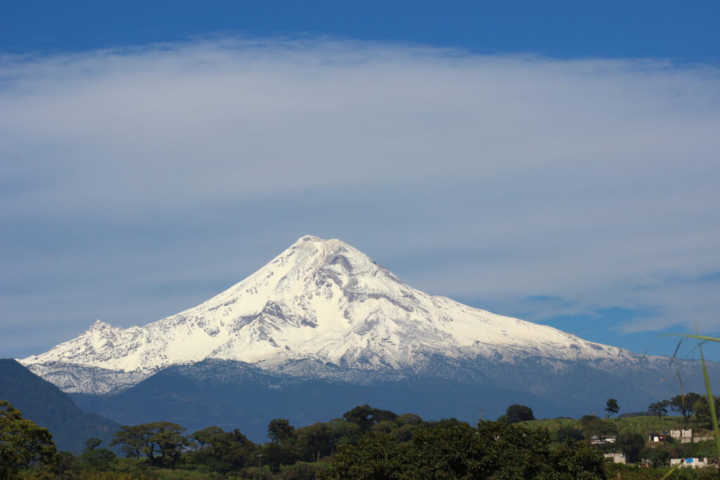
At 5,636 m (18,491 ft), Pico de Orizaba is the highest mountain in Mexico, the third-highest in North America (after Denali, 6,190 m, and Mount Logan, 5,959 m), and the continent’s highest volcano. It’s a dormant stratovolcano — last eruption around 1846 — whose summit cone holds the Jamapa Glacier, Mexico’s largest. Its altitude is almost exactly that of Elbrus (5,642 m — just 6 m higher), which is part of why it’s such a useful proving ground: it gives you real data on how your body handles 5,600 m before you commit money and weeks to Aconcagua or Denali. In Nahuatl it’s Citlaltépetl, “Star Mountain.”

Why altitude is the real challenge
The grade is moderate; the elevation is not.
Orizaba’s technical difficulty is modest — but its altitude profile is seriously demanding, and that mismatch is where people come unstuck. Climbers who arrive without prior acclimatisation fail far more often than any other group. Three realities drive that:
| The real challenge | Why it bites |
|---|---|
| The altitude itself | 5,636 m is above where most people have ever been. AMS, HAPE, and HACE are real risks above 5,000 m, and a summit day of 10–14 hours magnifies any altitude problem. |
| Cold & the long day | Summit mornings run roughly −10 to −20 °C with wind chill, on a push that starts around 1 a.m. Exhaustion and cold, not technical moves, are what end most attempts. |
| A moderate — but real — glacier | The upper Jamapa steepens to ~38°, there are at least a couple of crevasses, and the Labyrinth below it is loose mixed ground. You need crampon/ice-axe competence and, ideally, a rope team. |
The Jamapa Glacier route
Three sections: scree, the Labyrinth, and the glacier.
Jamapa Glacier from Piedra Grande
From Piedra Grande (4,270 m) the summit push starts around 1 a.m. so you cross the glacier while the snow is frozen, summit by 8–10 a.m., and get down before the afternoon softens it. The route climbs in three distinct sections:
| 1 · Scree approach (4,270 → ~5,000 m) | ~2 hrs on rocky volcanic scree by headlamp; crampons usually not yet needed. In snowy years it’s a packed trail; in dry years, loose route-finding. |
| 2 · The Labyrinth (~5,000 → 5,150 m) | The technical crux: a maze of mixed rock and ice gullies where the glacier has receded. Switch to crampons; route-finding in the dark trips up many parties. |
| 3 · Jamapa Glacier (~5,150 → 5,636 m) | Mellow ~20° low down, steepening to ~38° near the crater rim; a few crevasses. A short traverse around the rim reaches the true summit. |
Glacier retreat & the Labyrinth
Why old route descriptions don’t match the mountain anymore.
Older guides describe a snow “Tongue” that ran down from the glacier and gave a direct line from the scree to the ice. That tongue has melted out. The Labyrinth — today’s technical crux — exists precisely because the Jamapa Glacier has retreated and exposed the mixed rock-and-ice ground that used to be buried. The Jamapa is still Mexico’s largest glacier, but it’s shrinking (NASA has run ground-penetrating-radar studies of its thinning ice), and the route will keep changing as it does. It’s a good reason to climb with someone who knows this season’s conditions, and to treat any fixed route description — including this one — as a starting point, not gospel.
The acclimatisation ladder
The single biggest lever on your summit odds.
- La Malinche (4,461 m) — a non-technical day hike near Puebla; your first stress test above 4,000 m.
- Iztaccíhuatl (5,230 m) — a 2–3 day climb with snow travel, just ~400 m below Orizaba and the best single predictor of summit success.
- Sierra Negra (4,580 m) — optional, road-accessible to the observatory; an easy final day high.
Logistics & cost
Tlachichuca, a 4WD, a basic hut — and one of the best value big peaks anywhere.
Tlachichuca is the staging town, where operators like the long-running Servimont (the Reyes family) arrange the essential 4WD transfer, gear rental, and a meal before you head up. The Refugio Piedra Grande (4,270 m) is basic — three levels of plywood bunks for 40–50 people, no water, heat, or facilities, and no formal booking (a small donation). Bring a warm bag, a pad, food, and fuel.
| Option | 2026 cost (USD) | Notes |
|---|---|---|
| Premium US / Canadian guided | $2,800–$4,500 | 7–9 days, all Mexico logistics, English-speaking guides, group gear |
| Local Mexican operator | $800–$2,000 | Tlachichuca-based (Servimont, Orizaba Mountain Guides, others); great value |
| Independent | $400–$800 | 4WD transfer, hut donation, gear rental, food — for experienced, acclimatised climbers |
| Park entry / permit | Free / none | No permit required; national park has no entry fee |
Add international flights, personal gear, and travel insurance with high-altitude rescue cover — Mexican mountain-rescue infrastructure is limited, so that cover matters more here than the low headline price suggests.
Weather & when to climb
A dry-season peak — with a summit far colder than the hut.
Climb in the dry season, November–March, for stable weather and firm snow; December–February is the coldest but most predictable peak window. Because Orizaba sits near 19° N, conditions change more with elevation than with the month — but you still want the dry season. Avoid April–October (wet season: precipitation, unstable snow, afternoon storms). The live forecast below is for the Piedra Grande hut and refreshes on load.
Piedra Grande hut — Orizaba base camp (4,270 m)
Loading live data…Gear essentials
Full glacier kit for a cold, high summit day.
- Crampon-compatible mountaineering boots (B2/B3) + 12-point steel crampons with anti-balling plates, ice axe, and helmet (rockfall in the Labyrinth).
- Glacier gear: harness, belay device, locking carabiners, prusiks, and a rope for the team (guided groups supply group gear and ice screws).
- Cold-weather clothing: heavy down jacket (rated ~−20 °C), hardshell top and bottom, insulating mid-layers, plus heavy and liner gloves and a balaclava.
- Cat 3–4 glacier sunglasses and goggles, high-SPF sunscreen — high-altitude, low-latitude UV is intense.
- Sleeping bag to ~−15 °C (no heat at Piedra Grande), pad, headlamp with spares, insulated bottles/thermos, and high-calorie summit food.
Citlaltépetl: the Star Mountain
A sacred peak, and a landmark in North American mountaineering.
Long before the Spanish arrived in 1519, the volcano was sacred across Mesoamerica. Its Nahuatl name, Citlaltépetl, means “Star Mountain” — the snow cone gleams for hundreds of kilometres, and in Aztec tradition the god Quetzalcóatl climbed it to begin his journey to eternity, his soul rising as a quetzal that looked like a star. (Locals around Orizaba today more often call it Istaktepetl, “white mountain.”)
The first recorded ascent came in 1848, by two American soldiers, F. Maynard and William Reynolds, during the Mexican–American War — confirmed when a later party found their summit plaque. Mexican climber Martín Tritschler raised the national flag on top in 1873, and President Lázaro Cárdenas created the surrounding national park in 1937. Today Orizaba is the continent’s premier altitude proving ground — the mountain thousands climb to learn how they’ll handle the biggest peaks.
Frequently asked questions
How hard is Pico de Orizaba?
Technically moderate (PD, snow to ~38°), but the altitude is the real challenge: 5,636 m, a 10–14 hour day from a 1 a.m. start, sub-zero cold. You need crampon/ice-axe competence and good acclimatisation. Fit climbers routinely fail here from altitude, not difficulty.
How much does it cost?
Premium guided ~$2,800–$4,500; local Mexican operators ~$800–$2,000; independent ~$400–$800 (mostly the 4WD transfer, gear rental, and hut donation). No permit, free park entry.
How do you acclimatise?
On Mexico’s other volcanoes: La Malinche (4,461 m), then Iztaccíhuatl (5,230 m) — the best predictor of success — with Sierra Negra (4,580 m) optional. Most programs build this into 7–9 days with 3–4 nights above 3,000 m.
What is the Labyrinth?
The route’s crux: a mixed rock-and-ice maze around 5,000–5,150 m that appeared as the Jamapa Glacier retreated and its old “Tongue” snow section melted out. Route-finding through it in the dark is what stops many parties.
Do you need a permit or guide?
No permit, free park. No legal guide requirement, but most climbers use one for the glacier and route-finding. Independents need real glacier skills, acclimatisation, and rescue insurance.
When should I go?
November–March (dry season); December–February is the peak window. Avoid the April–October wet season. Summit mornings run about −10 to −20 °C with wind chill year-round.
How we built this
Research-based. This guide draws on CONANP park information, established Jamapa Glacier route references, and current operator logistics, cross-checked for elevation, route, acclimatisation, and season. Because the Jamapa Glacier is actively retreating, the route (especially the Labyrinth) changes year to year — we describe the current picture and flag that it will keep shifting.
Glacier conditions, operator pricing, and hut logistics change between seasons. Confirm current status with a Tlachichuca operator and check a high-altitude forecast before any attempt.
Test yourself at 5,600 m — the smart way
Orizaba rewards climbers who respect the altitude: basic glacier skills, a proper La Malinche/Iztaccíhuatl warm-up, and a 1 a.m. start with the discipline to turn around. Do it right and it’s the best rehearsal on the continent for the bigger peaks.
Orizaba progression plan → Mexico Volcanoes →Was this helpful?
🏔Related peaks nearby
🧭Explore & compare
Global Summit Guide is an independent mountaineering resource founded in 2026. The team combines first-hand trekking and climbing experience with in-depth research and professional health and nutrition review to help climbers choose objectives, prepare properly, and stay safe.
Health, altitude, and nutrition content is reviewed by Taylor Ludlow (Registered Nurse) and Brigg Hoopes (Nutritionist).
What We Don't Know Yet
Mountain information changes quickly. This box explains the limits of what this page can responsibly promise.
- Route conditions, snowpack, closures, and weather can change quickly after this page is updated.
- Permit rules, fees, quotas, and reservation windows may change between review cycles.
- Operator availability, pricing, guide ratios, and cancellation terms can change by season.
- Your fitness, altitude response, risk tolerance, and experience level may change what is safe or realistic.
- Use this page for planning guidance, then verify current information with official sources and qualified local experts before committing.
Verify current conditions with official land managers, guide services, local forecasts, and current route reports before booking or climbing.
Mountaineering, rock and ice climbing, glacier travel, and high-altitude activity are inherently dangerous and can result in serious injury or death. The information on Global Summit Guide is provided for general informational and educational purposes only and is not a substitute for professional instruction, qualified guiding, proper equipment, or your own judgment and experience.
Route conditions, weather, snowpack, permits, regulations, and hazards change constantly and may differ from what is described here. Details may be incomplete, out of date, or contain errors. Always verify current information with local authorities, certified guides, and official sources before making any decision in the mountains.
Nothing on this site is medical, legal, or financial advice. Our fitness, acclimatization, altitude, and nutrition content is general in nature; consult a qualified physician before beginning any strenuous exercise program or exposing yourself to high altitude.
You are solely responsible for your own safety and decisions. To the fullest extent permitted by law, Global Summit Guide and its team accept no liability for any loss, injury, damage, or expense arising from use of, or reliance on, this information. By using this site you acknowledge these risks and accept these terms.
Some links on this site may be affiliate links. If you buy through them we may earn a small commission at no extra cost to you; this never affects our recommendations.
Global Summit Guide recommendation path
Next Best Mountain to Research
Use these recommendations to continue the right planning path instead of stopping on one page.
Use current permit, weather, route, and operator information before booking or climbing.