
Last updated October 15, 2026
Japan · Kii Peninsula · UNESCO Pilgrimage
Kumano Kodo: Walk Japan’s Sacred Mountain Trails
For your first Kumano pilgrimage, follow the Nakahechi from Takijiri-oji to Kumano Hongu Taisha. Add Koguchi and Nachi for a challenging five-day journey through cedar forests, mountain villages, sacred shrines and hot springs.
Independent planning guide · Official route and difficulty references · Last source review: September 2026

The quick decision
Start with Nakahechi. It’s the Classic Kumano Kodo.
The Kumano Kodo is a network of ancient pilgrimage approaches, not one continuous trail. For most first-time walkers, Nakahechi offers the best mix of historical meaning, waymarked walking, village inns, public buses and flexible distances. The mountains are real: short daily distances still involve demanding climbs and descents.
Nakahechi
Walk Takijiri-oji to Hongu in about three days. Continue to Nachi if you want a longer and harder pilgrimage.
Kohechi
Cross remote mountain passes between Koyasan and Hongu over four demanding days, with fewer services.
Iseji & Ohechi
Explore eastern and coastal approaches with different historical characters and more involved logistics.
Understand the geography
Three Simple Route Maps
These diagrams explain route relationships—not turns, distances or GPX positions. Always use current Tanabe City official maps for navigation and closure checks.
01 · Kii Peninsula network
Several historic approaches lead toward the sacred Kumano landscape.
02 · Nakahechi core
Traditional western pilgrimage from Takijiri through mountain villages to Hongu.
03 · Hongu to Nachi
The eastern high-effort crossing travels through Ukegawa and Koguchi to Nachi.
Schematic maps are editorial orientation diagrams only. They are not navigation routes.
Routes compared
Which Kumano Kodo Route Fits Your Trip?
Choose the route based on experience and logistics, not whichever line looks shortest on a map.
| Route | Character | Best for | Logistics & difficulty |
|---|---|---|---|
| Nakahechi | Historic western approach to Hongu, optional Nachi extension | First pilgrimage, inn-to-inn walk, Dual Pilgrim | Best support; variable difficulty, harder east of Hongu |
| Kohechi | Koyasan → Hongu over remote mountain passes | Experienced mountain trekkers | Repeated difficult stages, limited options |
| Iseji | Long eastern approach with old stone paths and coast | Longer historical exploration | More complex transport and itinerary structure |
| Ohechi | Coastal route south from Tanabe | Selective historical coastal sections | Modern roads interrupt some stretches |
Sacred geography
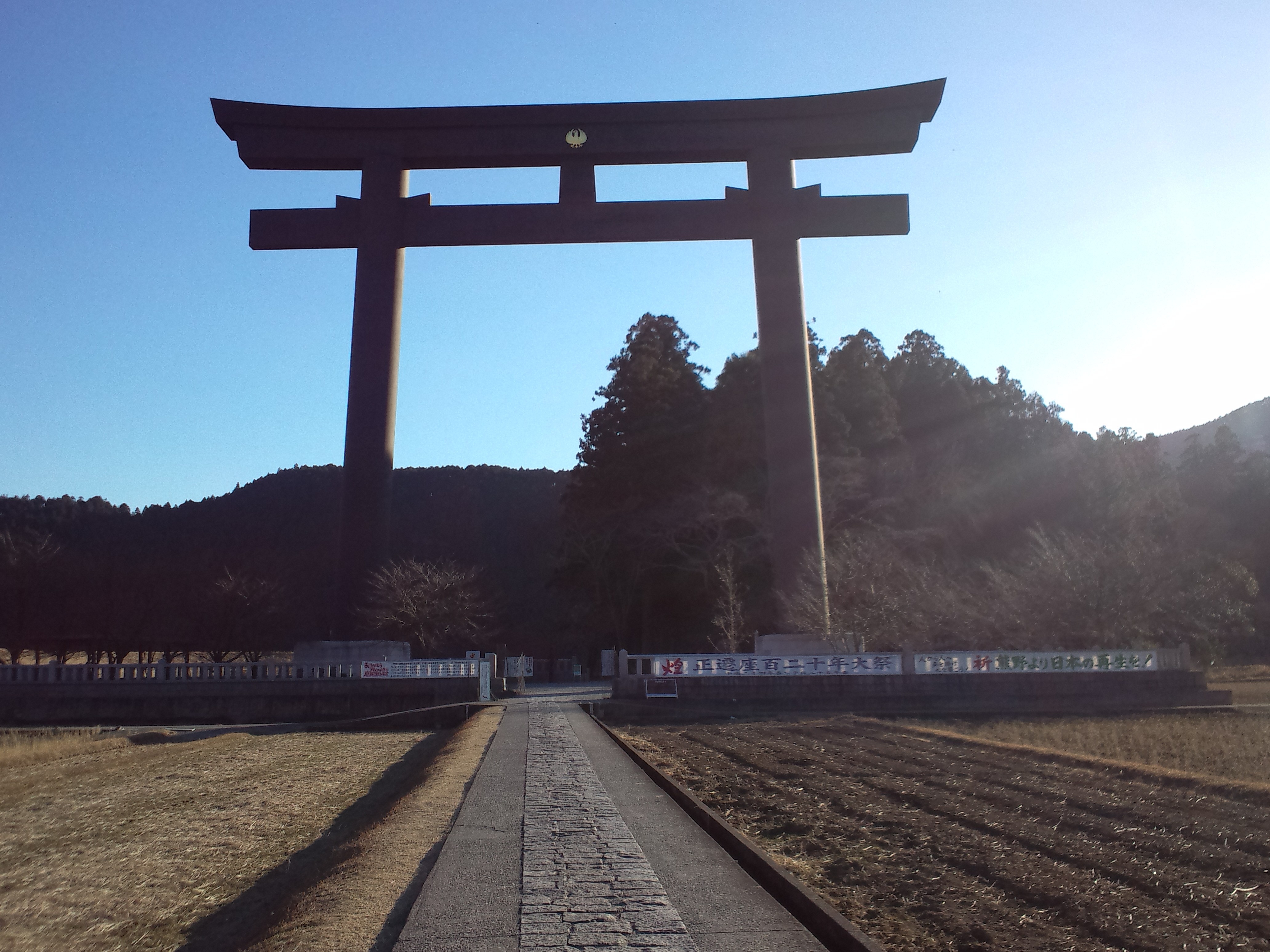
Oyunohara: The Threshold to Hongu.
The giant torii stands near the original site of Kumano Hongu Taisha. The shrine complex was moved to higher ground after devastating floods in 1889. A pilgrim entering Oyunohara sees that this is more than a scenic trail: the forest, river and shrines are woven into one sacred landscape.
UNESCO recognizes the sacred places and pilgrimage routes of the Kii Mountain Range as a cultural landscape shaped by the meeting of Shinto and Buddhist traditions.
Read UNESCO World Heritage listingA realistic walking plan
The Five-Day Nakahechi Itinerary
Walk the first half with time to absorb its history, then commit to the tougher mountain crossing to Nachi. Distances and hours are planning estimates; confirm current official stages and bus connections.
Takijiri-oji → Takahara
A short but steep opening climb into the sacred mountain corridor. Consider spending the previous night in Kii-Tanabe.
Takahara → Chikatsuyu / Tsugizakura
Forest walking through historic oji shrines and mountain villages; an extra stretch toward Tsugizakura changes the following day.
Chikatsuyu / Tsugizakura → Hongu
Your long western Nakahechi day. From Chikatsuyu, allow time for substantial climbing and descent; bus shortcuts may be appropriate.
Ukegawa → Koguchi (Kogumotori-goe)
Quieter mountain trail over the first of two eastern passes. Pack lunch and arrange a Koguchi overnight before departure.
Koguchi → Nachi (Ogumotori-goe)
The hard finale. Long climbs and slippery stone steps lead to the sacred Nachi shrine and waterfall complex.
A mountain trek, not a city walk
Short Kilometres. Steep, Slippery Days.
The standard Nakahechi needs no technical climbing, but roots, wet stone, repeated elevation change and few food stops can make 15 km feel longer than expected. The official difficulty ratings are especially high for the eastern traverse.
Up to 4/5
Long climbs and descents into the Hongu valley.
5/5
The most demanding section of this five-day itinerary.
Difficulty can rise with rain, heavier packs, shorter daylight and fatigue. Check official difficulty ratings.

The reason for the pilgrimage
Three Grand Shrines, One Sacred Landscape.
The Kumano Sanzan are linked by shared religious history but occupy different places in the landscape. A Nakahechi-focused walk naturally reaches Hongu and, with the eastern extension, Nachi. Hayatama in Shingu is a rewarding third visit using local transport.
Kumano Hongu Taisha
Inland spiritual center of the classic Nakahechi and the nearby Oyunohara torii.
Kumano Hayatama Taisha
Grand shrine close to the Kumano River and a natural stop when visiting Shingu.
Kumano Nachi Taisha
High sanctuary near Seiganto-ji and Nachi Falls, a remarkable meeting of shrine, temple and waterfall.


The onsen overnight
Yunomine Is Part of the Pilgrimage.
Yunomine Onsen is a historic hot spring village associated with purification rituals on the Kumano pilgrimage. The hillside Dainichi-goe connects the Hongu area with the village and adds its own steep steps.
A Yunomine overnight can provide recovery and cultural depth, but book early: small inns have limited rooms, and meal arrangements should be confirmed before walking.
Check community lodging optionsGetting the practical side right
Season, Inns, Luggage and Access
Spring & Autumn
Generally comfortable walking weather. Summer brings oppressive heat, humidity, rain and possible typhoons. Winter requires a conservative plan for short days and higher, colder sections.
Reserve Village Nights Early
Small settlements often have limited beds and set dinner times. Book Chikatsuyu/Nonaka, Hongu/Yunomine and especially Koguchi before finalizing the whole itinerary.
Enter Through Kii-Tanabe
Take the train from Osaka/Kyoto toward Kii-Tanabe and a local bus to Takijiri-oji. At the eastern end, Katsuura or Shingu make convenient railway exits.
Daypack + Inn-to-Inn Shuttle
Confirm transfer availability, deadlines and provider conditions before relying on it. Some services require both accommodations to be booked via the reservation system.
Two pilgrimage traditions
Kumano Kodo + Camino de Santiago = Dual Pilgrim
The official Dual Pilgrim program recognizes qualifying walks on both of these UNESCO-listed pilgrimage networks. Takijiri-oji to Kumano Hongu Taisha is one qualifying Kumano route option; other variants have separate requirements.
Kumano Kodo
Complete an eligible Kumano option and collect the required route evidence according to the official rules.
Camino de Santiago
Complete a recognized Camino requirement, generally the last 100 km on foot or 200 km by bicycle, with appropriate credentials and stamps.
Learn how the experiences differ in our Kumano Kodo vs Camino de Santiago comparison. Check the official Dual Pilgrim conditions before setting your itinerary.
What to carry
Build a Light, Rain-Ready Walking Kit.
Grippy hiking shoes
Tested trail shoes or light hiking footwear with reliable traction on wet roots and stone.
Rain shell + dry bag
Expect showers even in preferred seasons. Keep spare layers and overnight clothing dry.
Poles, light, lunch
Trekking poles help on descents. Carry food, water and a small headlamp on remote stages.
For Japan-specific walking options, see Best Hikes in Japan. For more demanding summit plans, read the Kilimanjaro guide or explore the mountain gear guide.

Trail reality
Quiet doesn’t mean easy.
Kumano combines a strong network of villages with sections where weather and footing matter more than distance. Plan each stage around the light, your lodging reservation and your personal mountain-walking experience.
Official Kumano hiking safety advice →Primary research sources
Verify the Details With Local Authorities.
Direct answers
Kumano Kodo FAQ
Which Kumano Kodo route is best for a first pilgrimage?
Nakahechi. The Takijiri-oji to Hongu core combines the richest first-time pilgrimage experience with useful transport, accommodation and signage.
How many days should I allow?
Allow three comfortable walking days for the Takijiri-to-Hongu core. Add two hard days through Koguchi to Nachi; a rest day near Hongu makes the extended trip more enjoyable.
How hard is the Nakahechi?
It is a non-technical mountain trek. Some western stages rate 4/5, while the demanding Ogumotori-goe stage rates 5/5 in the official system. Rain and heavy packs increase the challenge.
When is the best time to walk?
Spring and autumn generally offer the best walking conditions. Summer is hot, wet and humid; winter can bring short days, cold weather and snow or ice at higher elevations.
Do I need to reserve accommodation?
Yes. Small mountain villages have limited inventory. Reserve key stage-ending inns and confirm meals before booking onward travel.
Can my suitcase be transferred between inns?
Sometimes, using local luggage-transfer services. Service availability, booking conditions and required lead times vary by provider and lodging.
What is Dual Pilgrim recognition?
A program for walkers who complete qualifying Kumano Kodo and Camino de Santiago pilgrimages. Verify the eligible route sections and documentation before departure.
Keep researching
Connect Kumano to Your Next Pilgrimage.
The recommendation
Begin at Takijiri. Give Hongu Time.
The Kumano Kodo is most rewarding when it isn’t rushed into a one-hour photo stop. Walk the forest, stay in its villages and experience its sacred places. Continue to Nachi only when your fitness and timetable suit the harder eastern mountain stages.
Editorial planning reference. Trail status, transport, weather, booking conditions and pilgrimage recognition rules can change. Confirm official details before walking. Photography credited to creators under their respective Wikimedia Commons licenses; no endorsement implied.
Was this helpful?
Global Summit Guide is an independent mountaineering resource founded in 2026. The team combines first-hand trekking and climbing experience with in-depth research and professional health and nutrition review to help climbers choose objectives, prepare properly, and stay safe.
Health, altitude, and nutrition content is reviewed by Taylor Ludlow (Registered Nurse) and Brigg Hoopes (Nutritionist).
What We Don't Know Yet
Mountain information changes quickly. This box explains the limits of what this page can responsibly promise.
- Route conditions, trailhead access, crevasse exposure, stream crossings, and rescue access may vary from published planning guidance.
- Visa, passport, vaccination, border, insurance, and local transportation rules may change before your trip.
- Route conditions, snowpack, closures, and weather can change quickly after this page is updated.
- Permit rules, fees, quotas, and reservation windows may change between review cycles.
- Operator availability, pricing, guide ratios, and cancellation terms can change by season.
Verify current conditions with official land managers, guide services, local forecasts, and current route reports before booking or climbing.
Mountaineering, rock and ice climbing, glacier travel, and high-altitude activity are inherently dangerous and can result in serious injury or death. The information on Global Summit Guide is provided for general informational and educational purposes only and is not a substitute for professional instruction, qualified guiding, proper equipment, or your own judgment and experience.
Route conditions, weather, snowpack, permits, regulations, and hazards change constantly and may differ from what is described here. Details may be incomplete, out of date, or contain errors. Always verify current information with local authorities, certified guides, and official sources before making any decision in the mountains.
Nothing on this site is medical, legal, or financial advice. Our fitness, acclimatization, altitude, and nutrition content is general in nature; consult a qualified physician before beginning any strenuous exercise program or exposing yourself to high altitude.
You are solely responsible for your own safety and decisions. To the fullest extent permitted by law, Global Summit Guide and its team accept no liability for any loss, injury, damage, or expense arising from use of, or reliance on, this information. By using this site you acknowledge these risks and accept these terms.
Some links on this site may be affiliate links. If you buy through them we may earn a small commission at no extra cost to you; this never affects our recommendations.
Global Summit Guide recommendation path
Next Best Mountain to Research
Use these recommendations to continue the right planning path instead of stopping on one page.
Use current permit, weather, route, and operator information before booking or climbing.
Explore Travel Options for Your Destination
Once your mountain, dates and route are taking shape, compare flights, hotels and other travel options that fit the trip.
Affiliate link. We may earn a commission at no additional cost to you.