
Last updated July 11, 2026

How to Climb Longs Peak: The Keyhole Route, the Diamond & Colorado’s Icon
The highest peak in Rocky Mountain National Park, the northernmost 14er in the Rockies — and Colorado’s deadliest. The Keyhole Route needs no ropes, but its exposed scrambling, length, and daily afternoon storms have killed more climbers here than on any other Colorado mountain. Here’s how to climb it right.
Longs Peak (14,259 ft) is Colorado’s most iconic 14er and its deadliest. The standard Keyhole Route is “only” a Class 3 scramble, but that undersells it: 14–15 miles, ~5,100 ft of gain, 10–15 hours, and a mile-plus of seriously exposed scrambling above the Keyhole where a fall can be fatal.
It is not a first 14er. Come with prior Class 2 fourteeners behind you, start at 2–3 a.m. to beat the afternoon lightning, and be willing to turn around — most people who die here were tired, caught by weather, or in over their heads on the exposed sections. Respect it and it’s one of the great days in American mountaineering.
On this page
Find Hotels, Flights & Trips for the World’s Best Hiking Destinations
The Global Summit Guide Travel Shop on Expedia — curated for outdoor adventurers, mountaineers, and serious hikers. Patagonia to the Alps. Nepal to the Rockies. Curated lodging for every region we cover.
Explore Travel Shop on Expedia →Where it is
Rocky Mountain National Park, ~10 miles south of Estes Park via Highway 7.
Longs Peak rises in the northern Front Range within Rocky Mountain National Park, the highest point in the park and in Boulder County. Climbers start at the Longs Peak Trailhead (9,405 ft), at the Longs Peak Ranger Station off Highway 7 — about 9.5 miles south of Estes Park, roughly 65 miles from Denver. The tiny trailhead lot fills by the small hours; most climbers arrive by 2–3 a.m. or sleep in their vehicles the night before.
The peak, in brief
Iconic — but not Colorado’s highest, and definitely not its easiest.
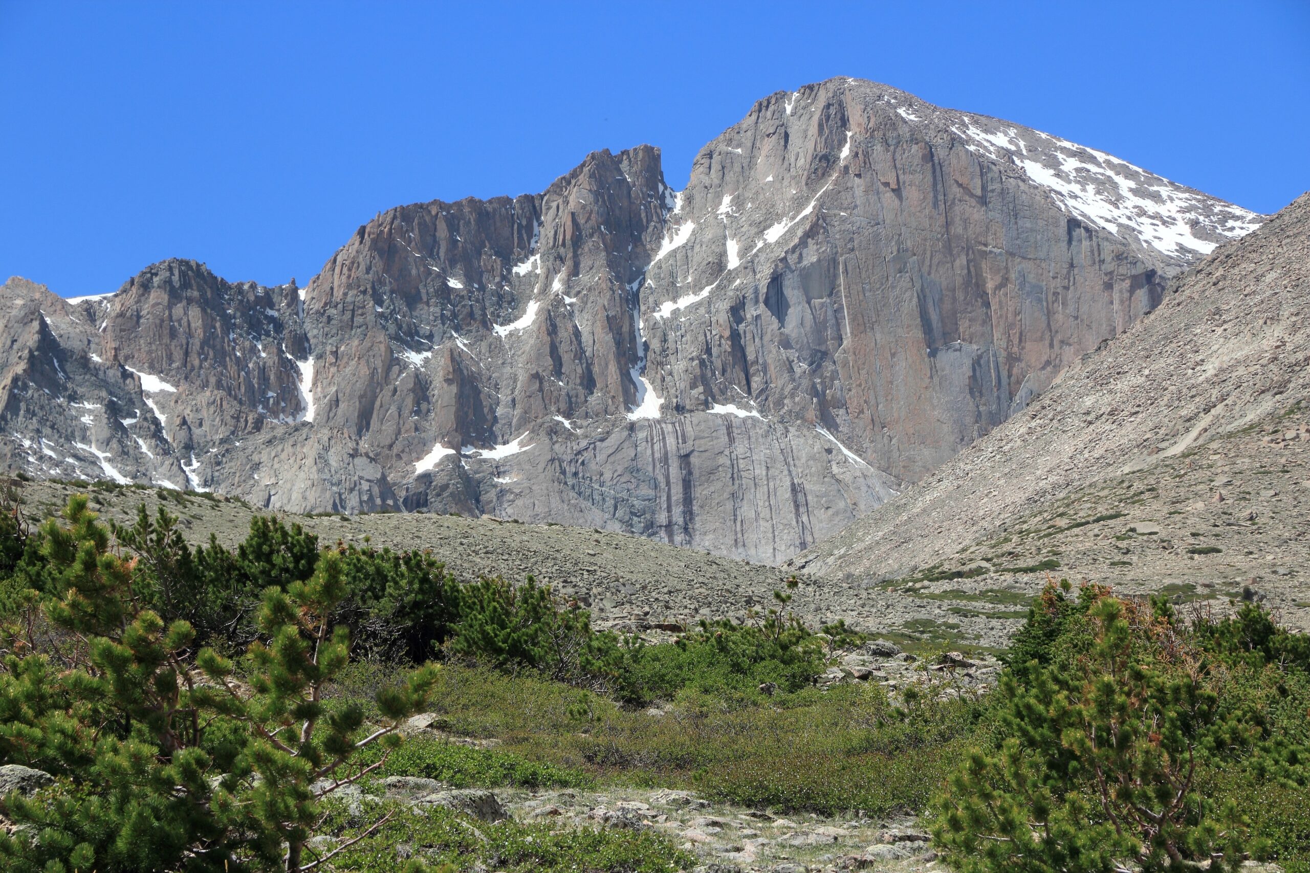
At 14,259 ft (4,346 m), Longs Peak is the highest summit in Rocky Mountain National Park and the northernmost 14er in the Rocky Mountains — roughly the 15th-highest of Colorado’s fourteeners (Mount Elbert, at 14,440 ft, is the state’s highest). What sets Longs apart is its concentration of climbing: it’s the most-climbed major peak in the Front Range, with around 30,000 people attempting all or part of it each year, and it holds more than 120 documented routes — more than any other mountain in the United States. Those range from the Keyhole scramble to some of the hardest free climbing in North America on its famous east face, the Diamond.
Why it’s Colorado’s deadliest 14er
The Class 3 rating describes the moves — not the day.
Longs Peak has recorded more climbing fatalities than any other Colorado mountain. The reasons cluster in four places, and none of them are exotic:
| The real hazard | Why it bites |
|---|---|
| Length + technical, together | Most CO 14ers are long-but-easy or short-but-technical. Longs is both: ~6 miles of hiking just to reach the Keyhole, then 1.3 miles of exposed Class 3, then the whole thing in reverse — most accidents happen on the tired descent. |
| Afternoon lightning | The Front Range builds thunderstorms almost daily in summer; lightning typically fires by noon–1 p.m. Anyone above the Keyhole then is exposed on bare granite. This has killed multiple climbers. |
| Exposure | The Ledges, Narrows, and Homestretch have no ropes but real fall consequences. Climbers comfortable in a gym or on Class 2 often freeze at the Narrows. |
| The “just another 14er” trap | Its national-park accessibility and Denver proximity make people underestimate it after easier peaks like Bierstadt or Quandary. Most fatalities involve limited experience and too little preparation. |
The Keyhole Route, section by section
The line ~95% of summiters take — and where the scrambling starts.
The Keyhole Route
The route climbs from the trailhead through forest and alpine tundra to the Boulderfield, reaches the Keyhole notch, then leaves hiking behind: a sequence of marked but exposed scrambling — the Ledges, the Trough, the Narrows, the Homestretch — leads to the summit. Above the Keyhole, the route is marked with red-and-yellow bullseyes; below it, it’s a trail.
| Trailhead → Boulderfield (9,405 → ~12,760 ft) | ~6 mi of trail through forest, then open alpine tundra; overnight campsites at the Boulderfield |
| The Keyhole (~13,150 ft) | The notch and the Agnes Vaille shelter — the go/no-go point. Assess weather and honestly assess yourself before crossing. |
| The Ledges | ~0.4 mi exposed traverse on the west face, following bullseyes |
| The Trough | ~600 ft steep boulder gully with loose rock; a short steeper crux at the top |
| The Narrows | Exposed ledge across the south face — the section that unnerves most people |
| The Homestretch → summit (14,259 ft) | ~300 ft of grippy granite slabs and cracks to the flat summit |
Summit day, hour by hour
A pre-dawn start isn’t a preference here — it’s the safety plan.
A typical Keyhole day: depart the trailhead by 2:30 a.m. by headlamp, reach the Boulderfield around dawn (~6:30 a.m.), and pause at the Keyhole (~7:30 a.m.) to commit or bail. The scrambling — Ledges, Trough, Narrows, Homestretch — takes most people 2–3 hours up, putting you on the summit around 9:30–10:30 a.m. Then it all reverses: back through the Keyhole by early afternoon and down to the trailhead by mid-to-late afternoon, roughly a 12–15 hour day.
The Diamond & other routes
Beyond the Keyhole: technical lines for experienced climbers.
The Keyhole is one of 120+ routes. The others are technical and require ropes and skills:
| Route | Grade | For |
|---|---|---|
| Keyhole Route | Class 3 | The standard scramble; ~95% of summits |
| Cables Route (North Face) | ~5.4 | Shorter, technical; the old cable was removed in 1973 (eye bolts remain) |
| Kieners Route (East Face) | 5.4 + snow | Classic alpine route via Lambs Slide and Broadway; crampons/ice axe/rope |
| The Diamond — Casual Route | 5.10a, IV | The easiest of the Diamond’s ~30 big-wall lines; strong trad climbers |
Access, permits & cost (2026)
One of the best-value big days in mountaineering — with a timed-entry wrinkle.
| Item | 2026 cost | Notes |
|---|---|---|
| RMNP entrance | $30 / vehicle (7 days) | Or $80 annual; America the Beautiful pass accepted |
| Timed-entry reservation | $2 | Only if entering 9 a.m.–2 p.m. (May 22–Oct 12); a pre-dawn start skips it |
| Boulderfield wilderness permit | fee + per-person | Only for overnight camping at ~12,760 ft; competitive, book early |
| Guided Keyhole Route | $500–$700 | e.g. Colorado Mountain School; day climb, small group |
Self-guided, that’s little more than the price of a park pass — one of the most affordable serious mountain days anywhere (for comparison, guided Rainier runs $1,500–$3,000 and Aconcagua $4,500+). No climbing permit is required to day-hike the Keyhole; you just need the entrance pass, the right conditions, and the preparation the mountain demands.
Weather & when to climb
A short summer window — and a summit far colder and stormier than the trailhead.
Mid-July through mid-September is the window, when the Keyhole is typically snow-free and climbable as a scramble; late July–August is peak. Early July can still hold snow in the Trough. From roughly October through May it’s a serious winter mountaineering route (crampons, ice axe, technical skills) — a different objective entirely. The live forecast below is for the trailhead and refreshes on load.
Longs Peak Trailhead (~9,400 ft)
Loading live data…Gear essentials
No technical kit for the summer Keyhole — but don’t go light on the essentials.
- Grippy footwear — sturdy, broken-in hiking boots or capable trail runners for boulder-hopping and slab scrambling.
- Layers for a big temperature swing — base layer, insulating mid-layer, an insulated jacket for the cold summit, plus a waterproof/windproof shell (top and bottom) for sudden weather; warm hat and light gloves.
- Helmet — strongly recommended above the Keyhole; rockfall from climbers above is the norm in the Trough.
- 3–4 L of water (none available above treeline), 800–1,200 kcal of food, and a headlamp with spare batteries for the 2–3 a.m. start.
- Sun protection (Cat 3+ sunglasses, SPF), trekking poles, a small first-aid kit, map/GPS as backup to the bullseyes, and an emergency bivy or space blanket.
A short history
From an 1868 survey party to the golden age of the Diamond.
The peak is named for Major Stephen Long, whose 1820 expedition sighted it from the plains. The first recorded ascent came on August 23, 1868, by a party led by one-armed Civil War veteran and Grand Canyon explorer John Wesley Powell, with newspaperman William Byers and others, via Keplinger’s Couloir. In 1873, Anna Dickinson — writer and suffragist — became the first recorded woman to summit.
Winter turned the mountain tragic in January 1925, when experienced climber Agnes Vaille died of exposure descending after a first female winter ascent of the east face; the stone shelter at the Keyhole was built in her memory in 1927 and still stands. The Park Service strung a cable up the North Face in 1925 (the “Cables Route”) and removed it in 1973 to restore the wilderness. And in 1960, Dave Rearick and Bob Kamps made the first ascent of the Diamond — opening the era of high-altitude big-wall climbing that, with the 1977 Casual Route and beyond, made Longs Peak one of the most storied walls in the country.
Frequently asked questions
How high and how hard is Longs Peak?
14,259 ft (4,346 m). The Keyhole Route is a Class 3 scramble — no ropes — but ~14–15 miles, ~5,100 ft of gain, 10–15 hours, and a mile-plus of exposed scrambling above the Keyhole make it the most demanding non-technical 14er in Colorado, and the deadliest by recorded fatalities.
Do you need a permit or timed-entry reservation in 2026?
RMNP timed entry (May 22–Oct 12) covers the Longs area but only for entry 9 a.m.–2 p.m. A 2–3 a.m. alpine start enters before that, so most climbers need no reservation — just the park entrance pass. Overnight Boulderfield camping needs a separate wilderness permit.
What time should I start?
By 2–3 a.m. Summit by ~10 a.m. and be below the Keyhole before the afternoon thunderstorms build. Late starts are the top factor in Longs Peak accidents.
Why is it the deadliest 14er?
Length plus exposed scrambling plus daily afternoon lightning, compounded by climbers underestimating it after easier 14ers. Most fatalities are falls on the exposed sections (often descending, tired) and lightning from late starts.
What’s the Diamond?
The ~900-ft vertical east face above Chasm Lake, entirely above 13,000 ft — a premier big wall. First climbed in 1960 (D1); the Casual Route (5.10a, 1977) is the popular line. It’s for experienced trad climbers, not Keyhole hikers.
When should I climb it?
Mid-July to mid-September for the snow-free Keyhole scramble; late July–August is peak. October–May is a technical winter climb needing crampons, ice axe, and skills.
How we built this
Research-based. This guide draws on Rocky Mountain National Park (NPS) and Recreation.gov 2026 access rules, standard 14er route references, and documented Longs Peak climbing history, cross-checked for elevation, route detail, access, and season. We corrected an outdated access claim: for 2026 the Longs Peak area is covered by RMNP timed entry (9 a.m.–2 p.m.), though a pre-dawn alpine start means most climbers never need a reservation.
Conditions, fees, and permit rules change between seasons. Confirm current status with RMNP (nps.gov/romo) and check a mountain-specific forecast before any attempt.
Climb Colorado’s icon — with respect
Longs Peak rewards climbers who prepare for it: prior Class 2 14ers, an honest head for exposure, a 2–3 a.m. start, and the discipline to turn around. Build up to it, and it’s one of the great days in the Rockies.
Colorado 14er progression → All Colorado 14ers →Was this helpful?
🏔Related peaks nearby
🧭Explore & compare
Global Summit Guide is an independent mountaineering resource founded in 2026. The team combines first-hand trekking and climbing experience with in-depth research and professional health and nutrition review to help climbers choose objectives, prepare properly, and stay safe.
Health, altitude, and nutrition content is reviewed by Taylor Ludlow (Registered Nurse) and Brigg Hoopes (Nutritionist).
What We Don't Know Yet
Mountain information changes quickly. This box explains the limits of what this page can responsibly promise.
- Route conditions, trailhead access, crevasse exposure, stream crossings, and rescue access may vary from published planning guidance.
- Route conditions, snowpack, closures, and weather can change quickly after this page is updated.
- Permit rules, fees, quotas, and reservation windows may change between review cycles.
- Operator availability, pricing, guide ratios, and cancellation terms can change by season.
- Your fitness, altitude response, risk tolerance, and experience level may change what is safe or realistic.
Verify current conditions with official land managers, guide services, local forecasts, and current route reports before booking or climbing.
Mountaineering, rock and ice climbing, glacier travel, and high-altitude activity are inherently dangerous and can result in serious injury or death. The information on Global Summit Guide is provided for general informational and educational purposes only and is not a substitute for professional instruction, qualified guiding, proper equipment, or your own judgment and experience.
Route conditions, weather, snowpack, permits, regulations, and hazards change constantly and may differ from what is described here. Details may be incomplete, out of date, or contain errors. Always verify current information with local authorities, certified guides, and official sources before making any decision in the mountains.
Nothing on this site is medical, legal, or financial advice. Our fitness, acclimatization, altitude, and nutrition content is general in nature; consult a qualified physician before beginning any strenuous exercise program or exposing yourself to high altitude.
You are solely responsible for your own safety and decisions. To the fullest extent permitted by law, Global Summit Guide and its team accept no liability for any loss, injury, damage, or expense arising from use of, or reliance on, this information. By using this site you acknowledge these risks and accept these terms.
Some links on this site may be affiliate links. If you buy through them we may earn a small commission at no extra cost to you; this never affects our recommendations.
Global Summit Guide recommendation path
Next Best Mountain to Research
Use these recommendations to continue the right planning path instead of stopping on one page.
Use current permit, weather, route, and operator information before booking or climbing.