
Last updated May 21, 2026
Mount Elbert Climb Guide: Colorado’s Highest Peak, the 1874 Stuckle First Ascent & the Mount Massive Cairn Rivalry (2026)
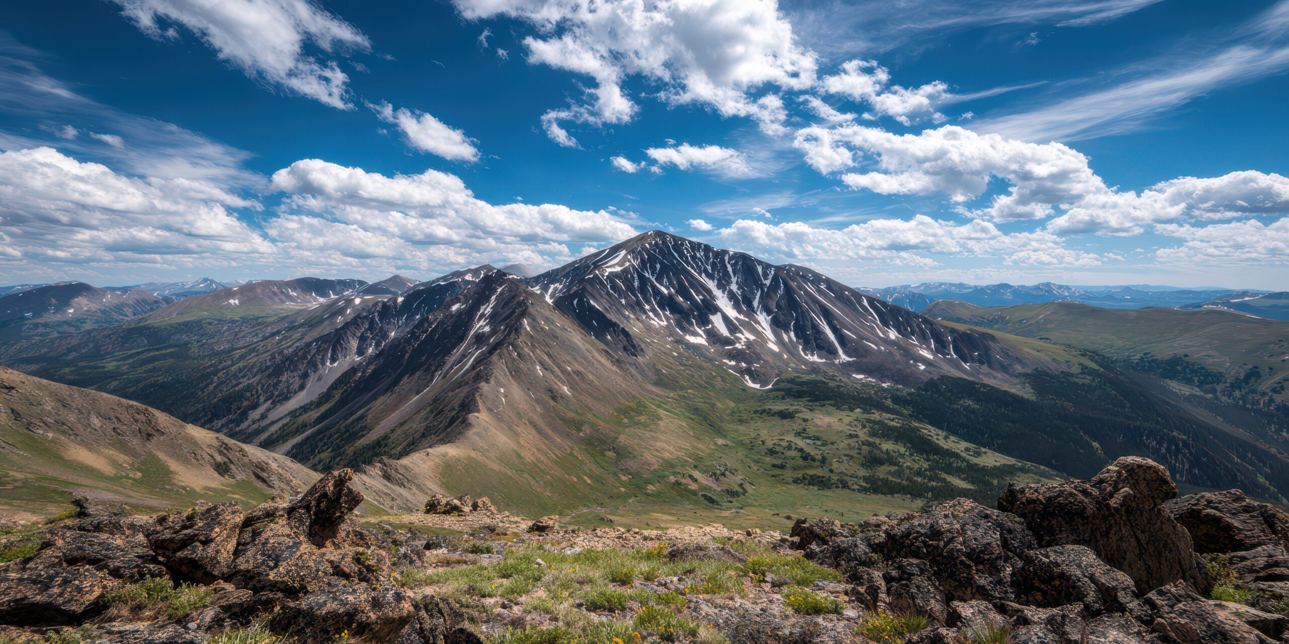
Mount Elbert is the highest mountain in Colorado, the highest in the Rocky Mountains, and the second-highest peak in the contiguous United States — yet most non-climbers have never heard of it. Climbed in 1874 by Henry W. Stuckle of the Hayden Survey, named after a controversial Colorado territorial governor, and standing just 19 feet taller than its neighbor Mount Massive (the basis of a famous decades-long cairn-building rivalry), Elbert is the “Gentle Giant” of the Rockies — a 14,440-foot peak with class 1 hiking trails that fool climbers into underestimating its altitude. Here’s the verified 2026 planning data.
San Isabel National Forest. Mount Elbert sits within the San Isabel National Forest — established in 1907 and covering 1.1 million acres / 4,400 km² across central and south-central Colorado. The forest is jointly managed with the Pike-San Isabel-Comanche-Cimarron National Grasslands by the US Forest Service. The Mount Elbert area falls within the Leadville Ranger District. Both the North Mount Elbert Trail (Halfmoon Creek drainage) and the South Mount Elbert Trail (Twin Lakes side) are managed and maintained by the USFS. The mountain itself is not within a designated wilderness area — it is in the multi-use National Forest where dispersed camping, motorized access on designated roads, and hunting are all permitted in season.
The History of Mount Elbert
Mount Elbert rises 14,440 feet (4,401 meters) in the Sawatch Range of central Colorado, approximately 16 km / 10 miles southwest of the historic mining town of Leadville. It is the highest peak in Colorado, the highest in the Rocky Mountains, and the second-highest peak in the contiguous United States — exceeded only by Mount Whitney in California (14,505 ft / 4,421m). The mountain is the highest point in Lake County, Colorado (which is itself the highest-elevation county in the contiguous US — Lake County’s lowest point is approximately 9,200 ft).
Despite its prominence, Mount Elbert is structurally a broad, rounded mountain rather than a sharp dramatic peak. The Sawatch Range generally consists of large, rounded summits formed from ancient Precambrian metamorphic rocks — substantially older and more eroded than the volcanic Cascades or the granite Tetons. Mount Elbert has a remarkable 9,093 feet (2,772m) of topographic prominence — making it the 23rd most prominent peak in North America and the 8th most isolated by topographic measurement.
Find Hotels, Flights & Trips for the World’s Best Hiking Destinations
The Global Summit Guide Travel Shop on Expedia — curated for outdoor adventurers, mountaineers, and serious hikers. Patagonia to the Alps. Nepal to the Rockies. Curated lodging for every region we cover.
Explore Travel Shop on Expedia →The Ute Sawatch Range Homeland. Mount Elbert sits in the ancestral territory of the Tabeguache Ute people (one of seven historical Ute bands), with overlapping use by the Mouache and Capote Ute bands. The Sawatch Range has been part of Ute homeland for at least 5,000-7,000 years, with summer hunting grounds, mineral hot springs, and trade routes throughout the region. The name “Sawatch” itself is a Ute-derived word commonly translated as “blue earth spring” or “water of the blue earth,” reflecting the region’s many mineral springs. The Ute people were forcibly removed from most of their Colorado homeland through a series of treaties and federal actions from the 1860s-1880s — including the September 1873 Brunot Agreement brokered by Samuel Hitt Elbert (the man for whom this mountain is named) that opened approximately 3 million acres / 12,000 km² of Ute reservation land to mining and railroad development. The Southern Ute Indian Tribe and Ute Mountain Ute Tribe today maintain cultural connections to the Sawatch region. Climbers should be aware they are on culturally significant Indigenous land with a difficult colonial history.
1859-1870s: The Leadville Mining Era and Sawatch Exploration
The Sawatch Range first attracted serious European-American attention during the Colorado Gold Rush of 1858-1859. Initial prospecting brought miners into the Arkansas River valley near present-day Leadville; the major silver and lead strikes that made Leadville famous came later (1877-1879). The 1860s-1870s saw systematic exploration of the central Colorado mountains by federal survey teams — the Hayden Survey (1871-1879), the Wheeler Survey (1871-1879), and the King Survey (1867-1879). These three federal surveys mapped the Rocky Mountains in detail and established the geological and topographic foundations for modern Colorado climbing.
Leadville itself was officially incorporated in 1878 and at its peak (1880) had a population of approximately 40,000 — briefly making it the second-largest city in Colorado after Denver. The town sits at 10,152 feet (3,094m) — making it the highest incorporated city in the United States, a distinction it retains today. Leadville remains the closest population center to Mount Elbert and is the standard service town for climbers approaching from the north side.
September 1873: The Brunot Agreement and the Elbert Naming
The mountain takes its name from Samuel Hitt Elbert (1833-1899), an Indiana-born attorney who came to Colorado Territory in 1862 and rose rapidly through territorial politics. President Abraham Lincoln appointed Elbert Secretary of the Colorado Territory in 1862; he later served as Governor of the Territory of Colorado from 1873 to 1874, and as Chief Justice of the Colorado Supreme Court from 1879 to 1883. Elbert was the son-in-law of John Evans — the second territorial governor (1862-1865) — through his marriage to Josephine Evans.
Elbert’s brief one-year governorship is most remembered for the September 1873 Brunot Agreement (also called the Brunot Treaty) — which he brokered with the Ute Tribe under federal commission. The agreement opened approximately 3 million acres (12,000 km²) of Ute reservation land to mining and railroad development. For Colorado mining interests — the economic engine of the territory at the time — the Brunot Agreement was a major windfall. For the Ute communities forced to cede their lands, it was a devastating blow that accelerated their displacement from traditional homelands. The mountain was named after Elbert by miners specifically to honor his role in the treaty. The naming is now widely recognized as part of the difficult colonial-history pattern of Colorado place names — alongside Mount Evans (named for John Evans, the architect of the Sand Creek Massacre context; renamed Mount Blue Sky in 2023). Mount Elbert has not been renamed and the historical context is increasingly acknowledged in Colorado mountaineering literature.
1874: Henry W. Stuckle’s First Recorded Ascent
The first recorded ascent of Mount Elbert was made in 1874 by Henry W. Stuckle, a member of the Hayden Survey. The Hayden Survey — led by Dr. Ferdinand V. Hayden (1829-1887) — was the most ambitious federal geological and topographic survey in American history at the time, mapping vast tracts of Wyoming, Colorado, and other western territories from 1871 through 1879. Henry Gannett (1846-1914), who later founded the National Geographic Society, served as the survey’s lead topographer and had climbed neighboring Mount Massive the previous year in 1873.
Stuckle’s 1874 Mount Elbert ascent was made primarily for surveying purposes — establishing elevation, position, and mapping landmark identification. He recorded an elevation of 14,433 feet using the survey methods of the era (revised upward to 14,440 ft in 1988 following NAVD 88 datum changes). Given the mountain’s relatively gentle terrain by 14er standards, it is almost certain that Stuckle was not literally the first human to summit Elbert — Ute tribal members and earlier 1858-1873 prospectors had likely visited the summit before formal documentation began. The Stuckle ascent is the first verified historical record rather than the literal first ascent.
1949: The First Jeep Summit
In 1949, Mount Elbert became one of the first mountains over 14,000 feet in the world to be summited by a motor vehicle. A jeep was driven to the summit by a small party reportedly assessing the potential for a ski resort in the Sawatch Range. The ski resort never materialized, but the jeep ascent demonstrated both the relative accessibility of the mountain and the post-World War II era’s enthusiasm for motorized exploration. The 1949 jeep summit is preserved in Colorado mountaineering history as a curiosity — and as one of the reasons Mount Elbert acquired its “Gentle Giant” reputation. Motorized access to the actual summit is no longer permitted under modern Forest Service regulations.
1930s-1980s: The Mount Massive Cairn Rivalry
One of the most charming stories in Colorado mountaineering history concerns the long-running rivalry between Mount Elbert and its closest neighbor, Mount Massive (14,421 ft) — located 8 km / 5 miles north-northwest of Elbert in the same Sawatch Range. The two peaks differed by only 12 feet in the original Hayden Survey measurements (Elbert 14,433 ft, Massive 14,421 ft) — a margin small enough that partisans of both mountains have spent over a century arguing about which is “really” highest.
Beginning sometime after the Great Depression (1929-1939), partisans of Mount Massive began building rock cairns on the Massive summit — attempting to literally engineer their preferred mountain to surpass Elbert as Colorado’s highest. The cairn-building effort was reportedly a serious if amusing undertaking; some accounts describe substantial stone piles intended to push Massive’s surveyed height above Elbert’s. Elbert supporters reportedly responded by climbing to the Massive summit and dismantling the cairns whenever they found them. The back-and-forth continued for decades and became a famous Colorado mountaineering legend.
The 1988 elevation revisions via the North American Vertical Datum (NAVD 88) settled the matter scientifically. Mount Elbert’s elevation was revised to 14,440 feet; Mount Massive to 14,421 feet — confirming Elbert as the higher peak by 19 feet. The cairn-building feud is now a beloved part of Colorado 14er folklore, and the two peaks remain neighbors sharing the same San Isabel National Forest jurisdiction. Climbers often climb both peaks in the same week as a “Sawatch double-header” — an excellent acclimatization and 14er progression itinerary.
1988: The Elevation Revision
Until 1988, Mount Elbert’s officially-recognized elevation was 14,433 feet — the figure measured by Henry Stuckle and the Hayden Survey in 1874. In 1988, the North American Vertical Datum (NAVD 88) recalibration of all US surveyed elevations revised Mount Elbert to 14,440 feet — a 7-foot increase. The change reflected improved survey methodology rather than any actual physical change in the mountain. Many older Colorado 14er reference materials, summit registers, and elevation signs still show the 14,433-foot figure; the 14,440-foot revised elevation is now the federally-recognized standard. The revision also confirmed that Mount Elbert is the 14th-highest US peak overall (when including Alaska’s much higher peaks) and the second-highest in the contiguous United States after Mount Whitney.
2020s-2025: Increasing Visitation and Trail Stewardship
Mount Elbert has seen substantial increases in summit attempts over the past two decades — driven by the broader “14er craze” in Colorado outdoor culture and the mountain’s reputation as the natural “first 14er” for many Colorado hikers. Annual summit attempts now exceed 30,000+; trail erosion has become a significant management challenge. The Colorado Fourteeners Initiative (founded 1994) has invested heavily in Mount Elbert trail maintenance and restoration; volunteer crew work continues on both the North and South Mount Elbert trails each summer. The 2025 season saw continuing high traffic, the canceled September 2025 Trailride-a-14er adaptive hike (weather), and ongoing trail stewardship investment.
The Gentle Giant — Why Mount Elbert Is Colorado’s Most Accessible Highest Peak
Mount Elbert occupies a paradoxical position in American mountaineering: it is the highest peak in Colorado and the second-highest in the contiguous United States, yet it is also among the most accessible 14,000-foot peaks in the world. No technical climbing skills required. No glacier travel. No rappels. No major exposure. The standard routes are class 1 hiking trails — the same rating as a moderately challenging local park trail. The “Gentle Giant” nickname captures this paradox perfectly: this is the highest peak in the Rockies, but you can walk to the summit.
What makes Mount Elbert structurally distinct from other major peaks:
- Class 1 standard routes. The Northeast Ridge route (North Mount Elbert Trail) is rated class 1 — entry-level hiking terrain. Compare: Mount Whitney’s Mountaineers Route is class 3-4; Longs Peak’s Keyhole Route is class 3 with substantial exposure; the Maroon Bells are class 4 to 5.4. Mount Elbert’s accessibility is genuinely exceptional for a 14er of this stature.
- The least technical “highest peak” in America. No other US state high point of comparable elevation has class 1 hiking access. Mount Whitney (CA, 14,505 ft) is 22 miles RT with permit lottery. Denali (AK, 20,310 ft) is a 14-21 day expedition. Mount Hood (OR, 11,250 ft) is technical glaciated climbing. Mount Rainier (WA, 14,410 ft) is multi-day glaciated mountaineering. Mount Elbert is a day hike from a roadside trailhead.
- Low avalanche danger. The broad, rounded shoulder of Mount Elbert produces less avalanche terrain than steeper Colorado peaks. The mountain is one of the few major Colorado 14ers regularly climbed in winter by experienced parties — the standard North Mount Elbert Trail has notably stable avalanche conditions compared to alpine routes on Longs Peak, the Maroon Bells, or the Crestones.
- Sawatch Range geography. Mount Elbert and Mount Massive share the same 5-mile / 8-km stretch of the Sawatch Range — a unique geographic clustering where the #1 and #2 peaks in Colorado are visible from each other. Climbers commonly attempt both in a “Sawatch double-header” itinerary.
- Excellent acclimatization profile. The standard trailheads (10,060 ft / 3,066m for North trail; 9,580 ft / 2,920m for South trail) sit well above 10,000 feet — providing built-in acclimatization for visitors driving from sea-level Denver. Combined with Leadville’s 10,152-foot base elevation, the entire area is excellent for high-altitude conditioning.
Where Mount Elbert fits in American mountaineering progression: Mount Elbert is the natural “first 14er” for many Colorado hikers — accessible class 1 trails, low technical demands, gentle terrain that doesn’t punish first-timer mistakes the way Longs Peak’s exposed sections do. The mountain teaches altitude management, endurance pacing, and Colorado lightning awareness that translate directly to harder 14ers. As standalone US goal, Mount Elbert is excellent — it’s Colorado’s highest peak, a genuine “state high point” achievement, and a meaningful elevation milestone. As preparation for higher peaks (Rainier, Denali, Aconcagua, Himalayan objectives), Mount Elbert provides altitude exposure without expedition complications. As preparation for Mount Whitney (the California sister peak — only 65 feet taller), Mount Elbert offers excellent training: similar altitude, similar non-technical character, similar acclimatization demands. As preparation for harder Colorado 14ers (Longs, Capitol, the Maroon Bells), Mount Elbert builds the altitude tolerance base for technical objectives.
Mount Elbert Historical Timeline
The Tabeguache Ute people (with overlapping use by Mouache and Capote Ute bands) occupy the Sawatch Range as part of their traditional homeland. The word “Sawatch” itself comes from Ute language, commonly translated as “blue earth spring” or “water of the blue earth,” reflecting the region’s many mineral springs. Summer hunting grounds, trade routes, and ceremonial sites throughout the Sawatch.
The Colorado Gold Rush brings the first European-American miners into the Sawatch Range and the Arkansas River valley near present-day Leadville. Initial prospecting focuses on placer gold; major silver and lead strikes (1877-1879) come later.
The Hayden Survey — led by Ferdinand V. Hayden — conducts the most ambitious federal geological and topographic survey in American history at the time. Henry Gannett (later founder of the National Geographic Society) serves as lead topographer. The Survey establishes the foundations of modern Colorado mapping.
Hayden Survey topographer Henry Gannett summits Mount Massive — Mount Elbert’s neighbor 8 km north-northwest. The Massive ascent precedes the Elbert ascent by one year and sets up the famous 12-foot elevation rivalry between the two peaks.
Samuel Hitt Elbert (Governor of Colorado Territory 1873-1874) brokers the Brunot Agreement with the Ute Tribe — opening approximately 3 million acres (12,000 km²) of Ute reservation land to mining and railroad development. Devastating to Ute communities; major economic windfall to Colorado mining interests. The mountain is named after Elbert specifically to honor his role in this treaty.
Hayden Survey member Henry W. Stuckle makes the first recorded ascent of Mount Elbert. Records elevation as 14,433 feet using survey methods of the era. Given the mountain’s gentle terrain, likely not the literal first human ascent — Ute tribal members and earlier 1858-1873 prospectors had probably visited the summit before formal documentation.
Leadville is incorporated in 1878. Population peaks at ~40,000 in 1880 — briefly the second-largest city in Colorado after Denver. At 10,152 feet, Leadville becomes the highest incorporated city in the United States (a distinction it retains today). Major silver and lead mining transforms the Sawatch economy.
San Isabel National Forest is established by Presidential proclamation. Mount Elbert is included within the forest boundaries. Modern forest covers 1.1 million acres / 4,400 km² across central and south-central Colorado. Provides the federal management framework that persists today.
Partisans of Mount Massive begin building rock cairns on the Massive summit to add height — attempting to engineer their preferred mountain above Elbert. Elbert supporters tear down the cairns when found. The back-and-forth feud continues for decades and becomes a famous Colorado mountaineering legend.
A jeep is driven to the Mount Elbert summit — one of the first 14,000-foot peaks summited by motor vehicle. Originally undertaken to assess the potential for a ski resort in the Sawatch Range. The ski resort never materialized, but the jeep ascent demonstrates the mountain’s relative accessibility. Motorized access is no longer permitted today.
The North American Vertical Datum (NAVD 88) recalibration revises Mount Elbert’s official elevation from 14,433 ft to 14,440 ft — a 7-foot increase reflecting improved survey methodology. Mount Massive simultaneously revised to 14,421 ft. The 19-foot difference settles the Elbert vs Massive rivalry scientifically. Confirms Elbert as the 2nd-highest peak in the contiguous US.
The Colorado Fourteeners Initiative (CFI) is founded to protect and maintain Colorado’s 14,000-foot peaks from increasing visitation impact. CFI invests substantially in Mount Elbert trail maintenance; volunteer crew work continues on both North and South Mount Elbert trails each summer. The organization becomes the standard stewardship reference for Colorado 14er climbing.
Mount Elbert sees substantial increases in summit attempts driven by the broader Colorado outdoor culture boom. Annual summit attempts exceed 30,000+. Trail erosion on the North Mount Elbert Trail becomes a significant management challenge. CFI and USFS invest in trail reconstruction, education, and visitor management.
A planned adaptive Trailride-a-14er event on Mount Elbert — designed to help adaptive athletes summit the mountain — is canceled due to weather. The cancellation reinforces a fundamental Colorado mountaineering lesson: even the most accessible 14er still answers to mountain conditions and afternoon thunderstorms.
2025 sees continuing high traffic on the standard routes, ongoing Colorado Fourteeners Initiative trail work, the canceled Trailride-a-14er event, and continued emphasis on noon-summit timing to avoid Colorado afternoon thunderstorms. The mountain continues to function as the standard “first 14er” for Colorado hikers building toward harder peaks.
The Mount Elbert Routes
Mount Elbert has three principal hiking routes used by virtually all summit climbers. The North Mount Elbert Trail (Northeast Ridge) is the standard and most popular line. The South Mount Elbert Trail offers a slightly longer alternative. The Black Cloud Trail provides a shorter but steeper option.
| Route | Side | Style | Distance / Gain | Status |
|---|---|---|---|---|
| North Mount Elbert Trail (Northeast Ridge) | North (Halfmoon) | Class 1 hike | 9.5 mi RT / 4,700 ft | ● Open · Standard · ~70% of ascents |
| South Mount Elbert Trail (East Ridge) | South (Twin Lakes) | Class 1 hike | 11.6 mi RT / 4,800 ft | ● Open · Alternative · ~25% of ascents |
| Black Cloud Trail | Southeast | Class 2 hike (steeper) | 10.5 mi RT / 5,400 ft | ● Open · Steeper Alternative |
| West Ridge (Bull Hill) | West | Class 2 hike | Variable; less developed | ● Open · Experienced Hikers |
| Winter Routes | Various | Winter mountaineering | Same as summer routes | ● Open · Winter Mountaineers Only |
North Mount Elbert Trail — The Standard Route (Stuckle’s 1874 Line)
Style: Class 1 hiking — non-technical trail · Used by ~70% of climbers.
Trailhead: North Mount Elbert Trailhead (10,060 ft / 3,066m), accessed via Halfmoon Creek Road (FSR 110) approximately 16 km / 10 miles southwest of Leadville. The road is rough gravel — 4WD/AWD recommended for the final mile but passable by passenger vehicles in dry conditions. Free parking; lot fills by 5-6 AM on summer weekends.
The Climb: 9.5 miles round trip · 4,700 feet of elevation gain · 4,401m summit altitude:
- Trailhead (10,060 ft) → Colorado Trail junction (10,500 ft): Initial ascent through aspen and lodgepole pine forest. Trail joins the Colorado Trail (CT) briefly. Well-defined route. ~30 minutes.
- Colorado Trail junction → Mount Elbert Trail split (11,000 ft): Continued ascent through forest; the Mount Elbert Trail departs from the Colorado Trail at a signed junction. ~45 minutes.
- Mount Elbert Trail split → Treeline (~11,500 ft): Switchbacks through dense Engelmann spruce forest. Trail well-maintained by Colorado Fourteeners Initiative crews. Emerge above treeline at approximately 11,500 ft. ~1-1.5 hours from trail split.
- Treeline → Lower Ridge (12,500 ft): Alpine terrain begins. The “false summit” pattern begins — climbers see what appears to be the summit ahead but discover the trail continues higher. ~1-1.5 hours.
- Lower Ridge → Upper Ridge (13,500 ft): Continued sustained climb on the broad northeast ridge. Significant elevation gain at altitude. Several “false summits” before the actual summit becomes visible. ~1-2 hours.
- Upper Ridge → Summit (14,440 ft): Final approach to the broad summit area. The actual summit is marked by a USGS benchmark and summit register. Excellent views of Mount Massive to the north, La Plata Peak to the south, and the Mosquito Range to the east. ~30-45 minutes.
Times: 5-7 hours up for strong hikers; 6-10 hours round-trip total. Most hikers complete in 7-8 hours; very slow hikers may need 9-10 hours. Trail running enthusiasts have completed the route in 2-3 hours.
Permit: None required. Free parking. No quota or registration.
South Mount Elbert Trail — The Twin Lakes Approach
Style: Class 1 hiking — similar character to the North trail but slightly longer · ~25% of ascents.
Trailhead: South Mount Elbert Trailhead (9,580 ft / 2,920m), accessed via Forest Service Road 125 (Lakeview Campground area) from the Twin Lakes side. Important note: 4WD vehicles can continue higher on FSR 125.B, substantially reducing trail length. Passenger vehicles should park at the lower trailhead and add approximately 2 miles to the climb.
The Climb: 11.6 miles round trip · 4,800 feet of elevation gain (from lower trailhead). The route ascends through aspen and lodgepole pine forest, joins the Colorado Trail briefly, then climbs the broad east-southeast ridge to the summit. Less crowded than the North trail. The South trail joins the same upper-mountain terrain as the North trail near the summit.
Why climbers choose it: Less crowded than the North Mount Elbert Trail (smaller parking lot, slightly less famous). Excellent for climbers staying near Twin Lakes or coming from the southwest. The Twin Lakes area provides scenic camping options and is closer to additional Sawatch peaks (La Plata, Mount Hope) for multi-peak trips.
The trade-off: Slightly longer than the North trail; the access road can be challenging in 2WD vehicles. Less well-known among first-time Colorado 14er climbers.
Permit: None required. Free parking at trailheads. No quota or registration.
Black Cloud Trail — The Steeper Southeast Alternative
Style: Class 2 hiking — steeper and less developed than the standard trails.
Trailhead: Black Cloud Trailhead, accessed via US Highway 82 from Twin Lakes. The trailhead sits at approximately 10,000 ft / 3,048m elevation.
Character: The Black Cloud Trail ascends a steeper southeast-facing line up the mountain, departing from the standard trail patterns. The route is approximately 10.5 miles round-trip with 5,400 feet of elevation gain — steeper sustained climbing than the standard routes. The trail is less developed and less crowded than the North or South Mount Elbert trails. Some sections feature looser footing and require modest route-finding awareness.
Why hikers choose it: Steeper character provides more substantive climbing experience than the gentle North trail. Quieter alternative for climbers who prefer solitude. Some local Colorado hikers prefer the Black Cloud line for its more “mountainy” feel. Good for repeat Elbert climbers seeking variation.
The trade-off: Substantially more demanding than the standard routes — 700 additional vertical feet over similar distance. The trail is less maintained and route-finding is occasionally required. Not recommended as a first Mount Elbert route — build through the North or South trails first.
Winter Mount Elbert and Other Routes
Winter mountaineering: Mount Elbert is among the most popular winter 14er objectives in Colorado. Three factors make winter climbing relatively accessible:
- Low avalanche danger on the standard North and South trails compared to steeper Colorado peaks
- Broad, rounded terrain that’s forgiving of route-finding errors in poor visibility
- No afternoon thunderstorm issue in winter (unlike summer where the storms are the dominant hazard)
Famous Colorado climber Lou Dawson — the first person to ski all 53 Colorado 14ers — has specifically recommended the South Mount Elbert Trail and the North Mount Elbert Trail for winter ascents. Winter conditions still require full winter mountaineering competence: cold exposure (regularly -20°C and below), short daylight hours, snow on the upper trail, and the absence of summer trail markings. Microspikes minimum; full crampons + ice axe for hard-snow conditions.
West Ridge / Bull Hill: A less-traveled west-side route ascending via Bull Hill. Class 2 hiking, less developed trail, route-finding required in places. Used primarily by experienced climbers seeking less-crowded alternatives. Approximately 11-12 miles RT with similar elevation gain to the standard trails.
Ski mountaineering: Mount Elbert is a popular spring ski-mountaineering objective. The broad upper slopes provide excellent ski terrain when snow conditions cooperate. Most ski descents are made from late April through early June. The Boxcar Couloir on the southeast face is a classic Colorado ski-mountaineering line.
The North Mount Elbert Trail Progression (Standard Route)
The standard Mount Elbert hiking route progresses through these named locations from trailhead to summit:
The “false summit” pattern is Mount Elbert’s psychological signature. The broad northeast ridge has at least 3-4 distinct “false summits” — points where the trail appears to be cresting the top, only for hikers to discover the actual summit is still ahead. The first false summit appears around 13,000 ft; another at 13,500 ft; a third at approximately 14,200 ft just below the true summit. The pattern is psychologically demanding at altitude — hikers experience the false reward of “almost there” multiple times before reaching the genuine top. Mental preparation matters: expect 3-4 false summits, plan your pace accordingly, and don’t celebrate prematurely. Long-time Elbert climbers describe the false-summit pattern as the mountain’s defining feature — what makes the “gentle giant” psychologically harder than the elevation profile suggests.
Costs & 2026 Logistics
Mount Elbert is one of the most affordable major US peak experiences — no permits required, free parking, no commercial guide requirements, and the standard service town (Leadville) offers economical lodging. Total trip budgets range from ~$100 (independent day-hike) to $500+ (guided overnight package).
| Item | Cost | Notes |
|---|---|---|
| North Mount Elbert Trail permit | $0 (free) | No permit required; no quota; no registration |
| North Mount Elbert Trailhead parking | $0 (free) | ~30 spaces; fills by 5-6 AM on peak weekends; arrive early |
| South Mount Elbert Trailhead parking | $0 (free) | Smaller lot; 4WD access higher via FSR 125.B |
| San Isabel National Forest entrance | $0 | No federal entrance fee |
| Halfmoon Campground (overnight) | $22-$26/night | USFS campground near North trailhead; first-come first-served |
| Lakeview Campground (overnight) | $22-$26/night | USFS campground near South trailhead; reservation via Recreation.gov |
| Dispersed camping (FSR areas) | $0 | Free dispersed camping in San Isabel NF; Leave No Trace required |
| Leadville lodging (per night) | $90-$200 | Delaware Hotel, Inn the Clouds, Silver King Inn, multiple motels; book ahead in summer |
| Twin Lakes area lodging | $120-$250 | Twin Lakes Inn, Twin Lakes Roadhouse, smaller B&Bs |
| Local gear rental (poles, packs) | $15-$50 | Bill’s Sport Shop (Leadville), various Aspen-area outfitters |
| Colorado Mountain Guides (guided) | $200-$400 | Guided day-hike programs available; less common than for technical 14ers |
| Travel from Denver | $60-$120 gas | 2-2.5 hours via I-70 + CO-91; common day-trip or weekend from Denver |
| Travel from Colorado Springs | $60-$120 gas | 2.5-3 hours via US-24; alternative approach via Buena Vista |
| Independent day-hike budget | $50-$150 USD | Just lodging + food + gas (assuming local gear ownership) |
| Independent 2-day weekend trip | $150-$350 USD | Per person — lodging + camping + food + travel |
| Guided trip (rare) | $300-$600 USD | Per person — guide fee + lodging + meals + travel |
| Full trip budget (2-3 days from Denver) | $200-$500 USD | Per person — modest lodging + food + gas; the cheapest “highest mountain in a state” goal in the US |
Mount Elbert is the cheapest major US “highest peak” experience. No other US state high point of comparable elevation comes close to Mount Elbert’s affordability. Mount Whitney (California’s highest) requires a competitive permit lottery and substantial lodging in Lone Pine ($400-$1,500+ total trip cost depending on travel). Mount Hood (Oregon’s highest) requires technical glaciated climbing with guide fees of $1,200-$2,000. Mount Rainier (Washington’s highest) requires multi-day guided expeditions at $1,650-$2,200. Mount Elbert can be completed as a day-trip from Denver for $50-$150 in total expenses (gas + food + a permit-less hike). The accessibility makes the mountain the natural “state high point” target for budget-conscious peakbaggers and the natural progression mountain for hikers building toward more expensive objectives.
Halfmoon Creek Road access reality. The road to the North Mount Elbert Trailhead (FSR 110, Halfmoon Creek Road) is rough gravel in the final mile — 4WD/AWD recommended for the final approach. Passenger vehicles can typically reach the trailhead in dry summer conditions but should drive slowly and carefully on the washboard sections. The road becomes much more challenging in wet conditions or early-season snow patches. Climbers driving rental cars from Denver International Airport should choose AWD or SUV options to ensure reliable trailhead access. Alternative: park at the lower switchback (~9,800 ft) and add approximately 0.5 mile to the climb if road conditions are uncomfortable.
Best Time to Climb & Sawatch Range Weather
The Mount Elbert hiking season runs from late June through mid-September, with prime conditions typically July and August. Mount Elbert is one of the few major Colorado 14ers regularly climbed in winter by experienced parties due to its relatively low avalanche danger.
| Period | Window | Conditions | Watch For |
|---|---|---|---|
| Winter | November – April | Snow on upper mountain; cold; suitable for experienced winter mountaineers | Cold exposure (-20°C+); short daylight; Halfmoon Creek Road may be closed; full winter gear required |
| Spring | April – June | Snow remaining on upper trail; microspikes or crampons recommended above treeline | Variable conditions year to year; potential mud below treeline; access roads may be muddy |
| Early Summer | Late June – Early July | Trail clearing of snow; warm days; popular Halfmoon Campground filling | Lingering snow above 12,500 ft in heavy-snow years; afternoon thunderstorms developing |
| Prime Season | July – August | Snow-free trail; warm temperatures; reliable conditions; peak crowds | Afternoon thunderstorms (predictable, daily); lightning above treeline; peak parking pressure |
| Late Season | September | Cooler temperatures; thinner crowds; spectacular aspen colors in foothills | Earlier sunsets; first new snow possible by mid-September; some campgrounds closing |
| Off-Season | October – March | Snow conditions; very cold; ski-mountaineering season Apr-Jun | Winter mountaineering competence required; Halfmoon Creek Road typically closed Nov-May |
The pre-dawn alpine start. Mount Elbert day-hikes typically begin at 3:00-5:00 AM from the trailhead — multiple hours before sunrise. The early start serves multiple purposes: (1) afternoon Colorado thunderstorms regularly produce lightning above treeline (~11,500 ft) starting at 11 AM-1 PM; (2) climbers must summit and descend below treeline before storms develop; (3) parking pressure makes early arrival mandatory; (4) the 6-10 hour round-trip needs the full daylight window. Headlamps are mandatory for the dark portion. Even in August, pre-dawn temperatures at the trailhead often drop below 4°C (40°F). Warm layers, gloves, and hat are essential.
Colorado afternoon thunderstorms — the dominant Mount Elbert hazard. The Sawatch Range has a famously predictable summer afternoon weather pattern: clear mornings, building cumulus clouds by 10-11 AM, frequent afternoon thunderstorms with lightning by 1-3 PM. Mount Elbert’s exposed broad ridge above 11,500 ft is particularly vulnerable to lightning strikes. Climbers who don’t summit by 11 AM-12 PM face elevated risk. Multiple historical lightning fatalities on Colorado 14ers document this hazard pattern. If thunder is heard, descend immediately below treeline regardless of summit proximity. Henry Gannett — the Hayden Survey topographer who climbed neighboring Mount Massive in 1873 — actually named Electric Peak in Yellowstone in 1872 after experiencing pre-lightning electric shocks near the summit; the same atmospheric phenomenon can occur on Colorado peaks. The Forest Service explicitly warns: “reach the summit by noon” — this is not a suggestion, it’s a safety protocol developed from 150 years of Colorado mountain weather observations.
Essential Gear Checklist
Mount Elbert gear requirements are standard Colorado 14er day-hike kit — substantially less elaborate than glaciated mountaineering peaks but more demanding than typical day hikes due to the 14,440-foot altitude and afternoon storm exposure. The mountain is the natural “first 14er” peak for many American hikers and the standard gear introduces concepts that scale to harder objectives.
Summer Trail (Prime Season)
- Trail running shoes or sturdy hiking boots
- Synthetic or merino base layers
- Lightweight insulating mid-layer (fleece or down jacket)
- Rain jacket / shell (lightweight; afternoon storm protection)
- Sun hat, baseball cap, or wide-brim hat
- Buff or neck gaiter
- Lightweight gloves for pre-dawn cold
- Sunglasses (Category 3-4)
- Headlamp + spare batteries (mandatory for early starts)
- Trekking poles (knees + balance for long descent)
Spring / Early Season
- Sturdy hiking boots (B1 if snow conditions)
- Microspikes for snow patches above treeline
- Crampons + ice axe for hard-snow conditions
- Self-arrest practice if attempting snow conditions
- Heavier insulation system (insulated jacket, warm hat)
- Hardshell jacket + pants
- Goggles in addition to sunglasses
- Heavier gloves + mitten reserve
- Gaiters for snow protection
Hydration & Food Strategy
- Minimum 2-3 liters water for day-hike
- Water filter if planning longer trip (Halfmoon Creek source available)
- Electrolyte tablets / sports drink mix (altitude depletes electrolytes)
- 2,000-3,000 calories of energy food (bars, gels, sandwiches)
- Extra reserve food for emergencies
- Caffeinated drinks/gels for the long day
Winter Mountaineering (Experienced Only)
- Mountaineering boots B2 (semi-rigid): Scarpa Charmoz, La Sportiva Trango
- Crampons with anti-balling plates (Petzl Vasak, BD Sabretooth)
- Ice axe (general mountaineering, 60-65cm)
- Self-arrest competence essential
- Avalanche beacon + shovel + probe (low-danger routes but still required)
- Heavier expedition-weight insulation (-20°C ratings)
- Goggles + balaclava + face protection
- Hand warmers + foot warmers
- Heavy-duty waterproof gloves + mittens
Difficulty & What Mount Elbert Actually Demands
Mount Elbert is misleadingly described as “an easy 14er” because of its class 1 hiking trails. The standard routes are genuinely non-technical — but the combination of 14,440-foot altitude, 4,700+ vertical feet, and Colorado afternoon thunderstorms makes Elbert substantially more demanding than the “Gentle Giant” reputation suggests. Five specific characteristics define what the mountain actually demands:
1. The altitude is the most common failure cause. 4,401m is high enough to produce moderate-to-severe altitude sickness (AMS) in unacclimatized climbers. Approximately 30-50% of Mount Elbert day-hike attempts fail to summit, with altitude-related symptoms (headache, nausea, severe fatigue, in rare cases HAPE) being the most common failure cause. Climbers driving from sea level (Denver flights from LAX, NYC, Chicago) to Leadville and attempting the climb the next day have substantially higher failure rates than those who spend 2-3 days at 7,000-10,000 ft elevation before the attempt. Spend at least one night in Leadville (10,152 ft) before the climb. This single acclimatization step substantially improves success rates.
2. The afternoon thunderstorm window is unforgiving. Sawatch Range summer afternoon thunderstorms force hikers to summit by approximately 11 AM-12 PM. The very early start times (3-5 AM trailhead departures) exist specifically to allow time to summit and descend the exposed upper trail before storms develop. Climbers caught above treeline in afternoon storms face genuine lightning risk — Colorado has multiple documented 14er lightning fatalities, including on neighboring peaks like Mount Massive and Mount Sherman. Trust the weather forecast; trust the turnaround time; if you can’t summit by noon, descend immediately.
3. The false summits are the psychological crux. The broad northeast ridge produces 3-4 distinct “false summits” — points where the trail appears to be cresting the top, only for hikers to discover the actual summit is still ahead. The pattern is psychologically demanding at altitude — hikers experience the false reward of “almost there” multiple times before reaching the genuine top. Most hikers who turn back voluntarily on Mount Elbert do so at one of the false summits — not because the route is too hard, but because the psychological gap between “I thought I was at the top” and “the actual top is still ahead” combined with altitude fatigue produces a hard mental moment. Mental preparation matters: expect 3-4 false summits, plan your pace accordingly.
4. The 9.5-mile round trip is genuinely long for a non-technical day. 9.5 miles RT with 4,700 vertical feet at altitude is substantially more demanding than most day hikes most climbers will have done. The “class 1 hiking” rating is accurate but doesn’t capture the endurance demand. Climbers who arrive thinking “it’s just hiking” frequently discover their longest previous hike was 4-6 miles at sea level. Training is genuinely necessary: weekly long hikes of 8-10 miles with 2,000+ feet of vertical gain for several months before the attempt substantially improve success rates. Trekking poles are not optional for the descent — they reduce knee strain by 20-30%.
5. Winter conditions transform the mountain completely. The “Gentle Giant” reputation applies only to summer. In winter (November-April), Mount Elbert becomes a serious mountain undertaking: temperatures regularly -20°C and below, cold exposure that can produce frostbite within minutes, short daylight hours (8-9 hours in December), and snow on the upper trails requiring crampons + ice axe + self-arrest competence. Halfmoon Creek Road typically closes November-May; winter climbers must add several miles of road approach. Winter Mount Elbert is among the most popular Colorado winter 14ers but requires full winter mountaineering competence — never attempt a winter climb of the mountain without prior winter mountaineering experience and complete winter gear.
What Mount Elbert rewards: Hikers with multi-thousand-foot elevation gain hikes already in their résumé, 1-2 days of altitude acclimatization at 7,000-10,000 ft elevation before the attempt, willingness to start in the dark (3-5 AM), discipline to turn around at the noon weather window, trekking poles for the long descent, mental preparation for the false-summit pattern, and respect for the altitude. As standalone “highest peak” goal, Mount Elbert is excellent — Colorado’s highest peak is a genuine state-high-point achievement and a meaningful elevation milestone. As preparation for Mount Whitney (the California sister peak just 65 feet taller), Mount Elbert provides ideal training — similar altitude, similar non-technical character, similar acclimatization demands but with more accessible logistics. As preparation for harder Colorado 14ers (Longs Peak, Capitol Peak, the Maroon Bells), Mount Elbert builds the altitude tolerance and endurance base. As preparation for international expeditions (Aconcagua, Denali, Himalayan peaks), Mount Elbert provides altitude exposure that scales. As “an easy hike” — no, this is not that. Approach Mount Elbert with respect for what 14,440 feet actually means.
Featured Guide Services & Operators
Mount Elbert’s class 1 character means the vast majority of climbers go independently — guided programs are uncommon for the standard summer hike. However, guided programs exist for hikers wanting structured support, group dynamics, winter ascents, or formal mountaineering instruction. Below are the established Mount Elbert guide and outfitter operators in 2026.
Colorado Mountain Club (CMC)
The oldest mountaineering organization in Colorado (founded 1912) operates regular Mount Elbert group climbs, training courses, and educational programs. CMC’s Mount Elbert programs combine the climb with formal mountaineering instruction including altitude management, weather assessment, and Colorado-specific safety. Membership-based but day programs available for non-members. Strong reputation as the Colorado standard for organized 14er climbing. cmc.org
Colorado Wilderness Rides and Guides (CWRG)
Colorado outfitter offering guided Mount Elbert hikes alongside other Colorado 14er programs. Day-hike and overnight programs available. Custom group hikes. Strong reputation for client preparation and altitude management. Often packaged with neighboring Mount Massive for “Sawatch double-header” itineraries. coloradowildernessridesandguides.com
Alpine Ascents Colorado
Colorado branch of the Pacific Northwest-based Alpine Ascents International. Offers Mount Elbert programs alongside other Colorado high-altitude objectives. Higher-touch programs with formal mountaineering instruction. Good for clients building progression to Rainier, Denali, or Aconcagua. alpineascents.com
Colorado Mountain School
Estes Park-based guide service offering Mount Elbert programs as part of broader Colorado mountaineering education. Strong for clients wanting to combine Mount Elbert with technical climbing instruction. Standard AMGA-certified guides. coloradomountainschool.com
Apex Mountain School
Colorado-based AMGA-affiliated mountain school offering Mount Elbert programs alongside formal mountaineering instruction. Good fit for climbers wanting structured progression and educational components. apexmountainschool.com
Colorado Fourteeners Initiative (Resources, Not Guides)
Not a guide service, but the standard stewardship and information organization for Colorado 14ers including Mount Elbert. CFI provides trail status updates, route descriptions, conservation programs, and volunteer opportunities. Essential resource for self-guided climbers. 14ers.org
Frequently Asked Questions
Mount Elbert rises to 4,401 meters (14,440 feet) in the Sawatch Range of central Colorado. It is the highest peak in Colorado, the highest in the Rocky Mountains, and the second-highest peak in the contiguous United States — exceeded only by Mount Whitney in California (14,505 ft / 4,421m). The original 1873 Hayden Survey measurement placed Elbert at 14,433 feet; the elevation was revised upward to 14,440 feet in 1988 following the North American Vertical Datum (NAVD 88) recalibration. Mount Elbert has an impressive 9,093 feet (2,772m) of topographic prominence — making it the 23rd most prominent peak in North America. The mountain ranks 27th-highest in North America and 8th in topographic isolation. Coordinates: 39.1178°N, 106.4453°W.
The first recorded ascent of Mount Elbert was made in 1874 by Henry W. Stuckle, a member of the Hayden Survey. The Hayden Survey (1871-1879) was the federal government’s pioneering geological and topographic survey of the American West, led by Ferdinand V. Hayden. Stuckle climbed Elbert as part of his survey work and recorded the ascent in official documents. However, given the mountain’s relatively gentle terrain by 14er standards, it is almost certain that the actual first summit predates Stuckle’s recorded ascent. The Ute peoples — who inhabited the Sawatch Range region for thousands of years before European-American arrival — likely summited the peak well before formal documentation began. Hayden Survey topographer Henry Gannett (who later founded the National Geographic Society) had climbed neighboring Mount Massive the previous year in 1873. The Stuckle ascent is the verified historical “first.”
Mount Elbert is widely known as the “Gentle Giant” of the Rockies because despite being the highest peak in Colorado and the second-highest in the contiguous US, its standard hiking routes are surprisingly accessible — class 1 to class 2 terrain (A+ in older Yosemite Decimal System parlance), meaning standard hiking trails with no technical climbing required. By comparison, peaks of similar height (Mount Whitney at 14,505 ft, Mount Massive at 14,421 ft) require more challenging approaches. The “gentle giant” nickname reflects this paradox: the highest peak in Colorado is also one of the most accessible. The nickname appears in mountaineering literature dating back to the early 20th century and is now the mountain’s standard informal name. The accessibility has led to over 30,000 annual summit attempts and a substantial “first 14er” demographic among Colorado hikers.
Mount Elbert (14,440 ft) and its 8-km-distant neighbor Mount Massive (14,421 ft) differ in elevation by only 19 feet — and historically, when survey measurements placed them just 12 feet apart, this small gap touched off one of American mountaineering’s most amusing rivalries. After the Great Depression, partisans of Mount Massive began building rock cairns on the Massive summit to add height — attempting to literally engineer their preferred mountain to surpass Elbert as Colorado’s highest. Elbert supporters reportedly tore down these cairns whenever they found them. The cairn-building feud continued for decades and became a famous Colorado mountaineering legend. The 1988 NAVD 88 elevation revision settled the matter scientifically: Elbert at 14,440 ft, Massive at 14,421 ft. The rivalry is now a beloved part of Colorado 14er folklore — and the two peaks remain neighbors, sharing the same San Isabel National Forest jurisdiction and the same Hayden Survey first-ascent era.
Mount Elbert is named after Samuel Hitt Elbert (1833-1899) — a Colorado statesman who served as Governor of the Territory of Colorado from 1873 to 1874. Elbert is a politically complicated figure: he was named the mountain by miners in honor of his September 1873 Brunot Agreement (also called the Brunot Treaty), which he brokered with the Ute Tribe. The treaty opened approximately 3 million acres (12,000 km²) of Ute reservation land to mining and railroad development — making it deeply controversial. The treaty was a major economic boon to Colorado mining interests but devastating to Ute communities, who were forcibly removed from much of their traditional territory. Samuel Elbert was the son-in-law of John Evans (the second governor of Colorado Territory; another Colorado 14er — Mount Evans — was named after him, though Mount Evans was renamed Mount Blue Sky in 2023 due to Evans’s role in the Sand Creek Massacre context). Both Elbert and Evans names reflect the difficult colonial history of Colorado place names.
The North Mount Elbert Trail (also called the Northeast Ridge route) is the standard summit route. The trail starts at the North Mount Elbert Trailhead (10,060 ft / 3,066m) — about 16 km / 10 miles southwest of Leadville. Round-trip distance is 9.5 miles / 15.3 km with 4,700 feet of elevation gain. The route is class 1 hiking — well-maintained trail through aspen and lodgepole pine forest, emerging above treeline at approximately 11,500 ft, then ascending the broad northeast ridge to the summit. Total time: 6-10 hours round-trip for most hikers; 5-7 hours for strong hikers. The South Mount Elbert Trail (5.8 miles one-way from Twin Lakes side, accessed via FSR 125) is the alternate standard route. The Black Cloud Trail is the shorter but steeper class 2 alternative. All three routes are non-technical in summer conditions but require winter mountaineering competence outside snow-free season.
No permit is required to climb Mount Elbert via any of the standard hiking routes. The mountain is in San Isabel National Forest, where hiking is unrestricted and free. There is no quota or lottery system. Free parking is available at both North Mount Elbert and South Mount Elbert trailheads, though parking lots fill early on summer weekends — arrive by 5-6 AM during July-August to guarantee a spot. The Halfmoon Creek area (north side) and the FSR 125 access road (south side) accommodate dispersed camping and overnight parking. Backcountry overnight stays in the wilderness require following Leave No Trace principles but no permit registration. Note that the access roads can be rough — 4WD vehicles can drive higher on FSR 125 on the south side, substantially reducing trail length. Standard 2WD vehicles should park at the lower trailheads.
The standard Mount Elbert hiking season runs from late June through mid-September, with prime conditions typically July and August. Snow on the upper trails can persist into early July in heavy-snow years; first new snow can return as early as mid-September. Spring (April-May) conditions require microspikes or crampons and self-arrest competence. Mount Elbert is also a popular winter climbing destination — the mountain has relatively low avalanche danger on the standard routes compared to other Colorado 14ers, making it a favored winter mountaineering objective for experienced parties. Climbers must always plan to summit by noon to avoid Colorado afternoon thunderstorms — the single biggest hazard on the mountain. The Forest Service explicitly warns hikers that severe or wintery conditions can develop at any time, even in summer. Very early starts (3-5 AM trailhead departures) are mandatory for day-hike summit attempts.
Mount Elbert is often recommended as a reasonable “first 14er” because the standard routes are class 1 hiking trails with no technical climbing required. A fit beginner with proper preparation and acclimatization can summit Mount Elbert. However, the 14,440-foot altitude is high enough to produce significant altitude sickness in unacclimatized climbers, and the 9.5-mile round trip with 4,700 vertical feet is substantially more demanding than most day hikes most beginners will have done. Recommended preparation: (1) train extensively with multi-thousand-foot vertical gain hikes for several months, (2) acclimatize for at least one night in Leadville (10,152 ft) before the climb, (3) start in the dark (3-5 AM), (4) carry plenty of water and electrolytes, (5) be willing to turn back if AMS develops or weather threatens, (6) use trekking poles for the long descent.
Mount Elbert sits in the Sawatch Range of central Colorado, approximately 16 km / 10 miles southwest of the historic mining town of Leadville. Coordinates: 39.1178°N, 106.4453°W. The mountain is in Lake County (the highest-elevation county in the contiguous US — its lowest point is approximately 9,200 ft) and within San Isabel National Forest. Major airports: Denver International Airport (~210 km / 130 miles to the east, 2-2.5 hours by car); Colorado Springs Airport (~210 km / 130 miles to the southeast, 2.5-3 hours by car). The main service town is Leadville, CO (population ~2,700), located along US Highway 24 at 10,152 ft — the highest incorporated city in the United States. Alternative service towns: Buena Vista, CO (35 km south); Twin Lakes village (5 km south of the mountain itself).
Mount Elbert Map & Leadville Weather
Mount Elbert summit coordinates: 39°07’04″N 106°26’43″W (39.1178°N, -106.4453°W). The map below shows the summit’s position in the Sawatch Range. Live weather is shown for Leadville, CO (3,094m / 10,152 ft) — the standard staging town and the highest incorporated city in the US. Summit conditions are typically 15-22°C colder than Leadville due to the additional 4,300 feet of elevation gain.
Mount Elbert Trail Access & Parking Logistics
Was this helpful?
🏔Related peaks nearby
🧭Explore & compare
Global Summit Guide is an independent mountaineering resource founded in 2026. The team combines first-hand trekking and climbing experience with in-depth research and professional health and nutrition review to help climbers choose objectives, prepare properly, and stay safe.
Health, altitude, and nutrition content is reviewed by Taylor Ludlow (Registered Nurse) and Brigg Hoopes (Nutritionist).
What We Don't Know Yet
Mountain information changes quickly. This box explains the limits of what this page can responsibly promise.
- Permit availability, reservation windows, quotas, and official fee rules may change after this page is updated.
- Route conditions, trailhead access, crevasse exposure, stream crossings, and rescue access may vary from published planning guidance.
- Comparisons simplify complex decisions; the better mountain depends on current conditions, skills, timing, budget, and risk tolerance.
Verify current conditions with official land managers, guide services, local forecasts, and current route reports before booking or climbing.
Part of this Global Summit Guide cluster
Explore the complete Mountains guide for more context, routes, planning links, and related resources.
Mountaineering, rock and ice climbing, glacier travel, and high-altitude activity are inherently dangerous and can result in serious injury or death. The information on Global Summit Guide is provided for general informational and educational purposes only and is not a substitute for professional instruction, qualified guiding, proper equipment, or your own judgment and experience.
Route conditions, weather, snowpack, permits, regulations, and hazards change constantly and may differ from what is described here. Details may be incomplete, out of date, or contain errors. Always verify current information with local authorities, certified guides, and official sources before making any decision in the mountains.
Nothing on this site is medical, legal, or financial advice. Our fitness, acclimatization, altitude, and nutrition content is general in nature; consult a qualified physician before beginning any strenuous exercise program or exposing yourself to high altitude.
You are solely responsible for your own safety and decisions. To the fullest extent permitted by law, Global Summit Guide and its team accept no liability for any loss, injury, damage, or expense arising from use of, or reliance on, this information. By using this site you acknowledge these risks and accept these terms.
Some links on this site may be affiliate links. If you buy through them we may earn a small commission at no extra cost to you; this never affects our recommendations.
Global Summit Guide recommendation path
Next Best Mountain to Research
Use these recommendations to continue the right planning path instead of stopping on one page.
Use current permit, weather, route, and operator information before booking or climbing.