
Last updated May 27, 2026
Pikes Peak Complete Guide 2026 — Colorado’s Famous 14,115 ft Front Range Summit, Fred Barr’s Historic 13-Mile Trail, the Cog Railway Resurrection, and Why America’s Mountain Demands Real Discipline Despite Its Tourist Infrastructure
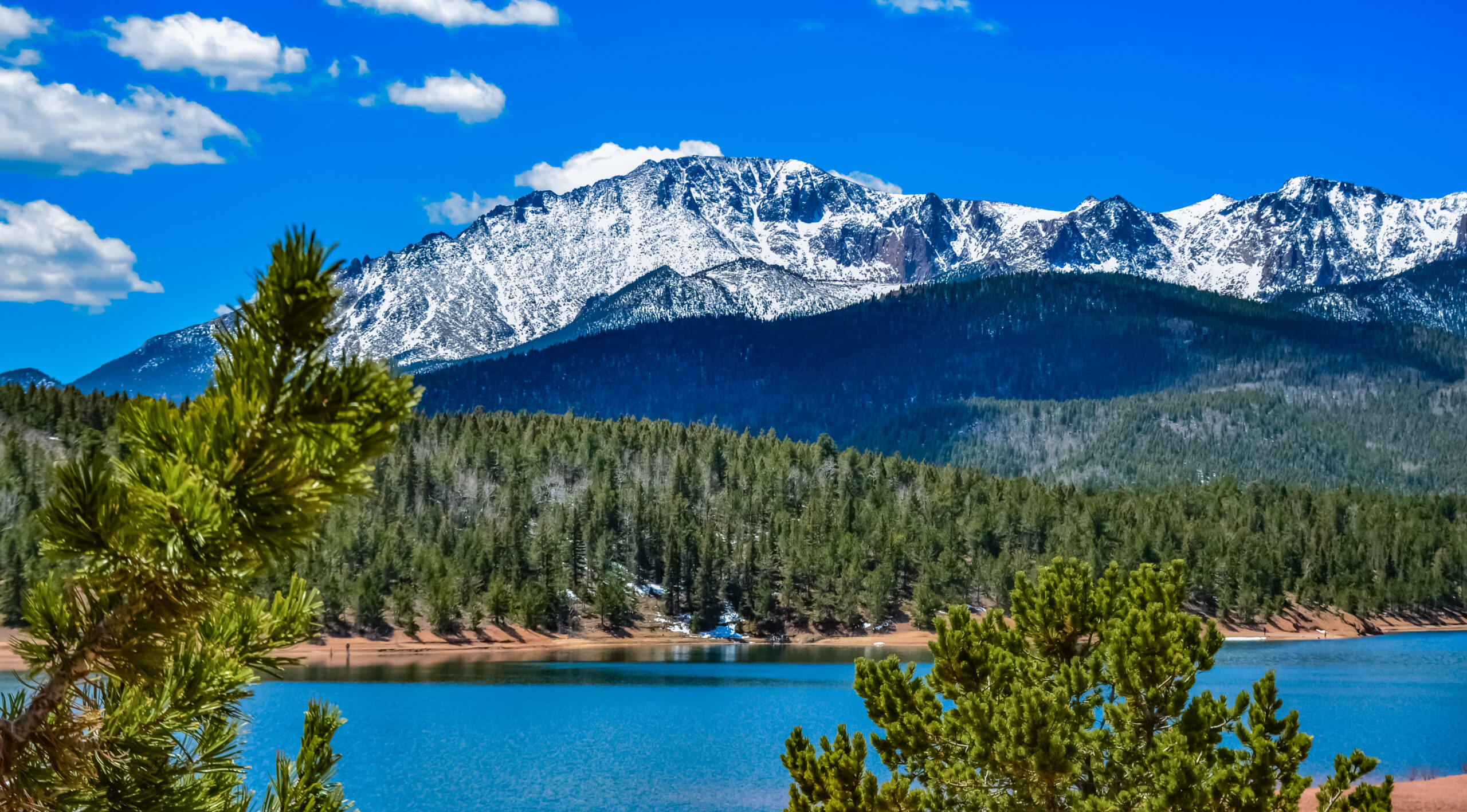
Pikes Peak rises 14,115 ft (4,302 m) above Colorado Springs. Notably, the mountain ranks as one of Colorado’s most famous 14ers and the most accessible major 14,000-foot peak in the United States. Generally, the mountain combines genuine high-altitude hiking via Fred Barr’s historic 13-mile Barr Trail (7,400-7,800 ft of elevation gain from Manitou Springs). The peak also offers full vehicle access via the 19-mile Pikes Peak Highway and the historic Manitou & Pikes Peak Cog Railway. Specifically, summit access by road costs $18 adult plus $2 timed-entry permit in 2026, while the Barr Trail demands 6-10 hours up plus the descent. Notably, the mountain inspired Katharine Lee Bates to write “America the Beautiful” in 1893 — a song still synonymous with the peak today. The Forest Service rates Barr Trail as “more difficult” and explicitly recommends against single-day round trips for hikers not used to high altitude. The tourist infrastructure conceals the actual physical demand of the standard hiking route.
Pikes Peak is one of the most famous summits in the United States and one of the most approachable 14ers from a logistics standpoint. Generally, what makes the mountain unique is the range of ways to reach the top — a classic long trail climb via Fred Barr’s historic Barr Trail, a shorter Crags-Devils Playground hiking route from the west side, the scenic 19-mile Pikes Peak Highway, or the historic cog railway. Specifically, summit tourism on Pikes Peak creates a dangerous expectation gap. Notably, the easy summit access by road or rail makes many hikers underestimate the actual climb — a hard lesson the U.S. Forest Service formally warns against in its trail rating.
This guide answers what serious climbers and hikers ask about Pikes Peak. Which route fits your fitness and time budget? What does the standard Barr Trail actually demand? What 2026 access costs apply? Notably, we’ll cover several concrete topics. First, the four main summit access methods with verified milestones, distances, and elevations. Then the historic Barr Trail built by Fred Barr in the early 1900s and rebuilt by USFS in the late 1950s. The route includes Barr Camp at mile 6.5 at 10,200 ft and the A-Frame timberline shelter at mile 9.0 at 11,900 ft. Also 2026 Pikes Peak Highway timed-entry system with $18 admission plus $2 permit fee. Plus the Manitou & Pikes Peak Cog Railway resurrection after the 2017-2020 reconstruction. Also the race culture. The events include Pikes Peak Ascent & Marathon September 20-21, 2026, Barr Trail Mountain Race July 2026, and Pikes Peak International Hill Climb closing the highway June 21, 2026. Plus weather and seasonal planning for the May through October main window. Finally, why the easy summit access by road doesn’t reduce the demand of the hiking routes.
Pikes Peak At a Glance
| Specification | Value | Context |
|---|---|---|
| Summit elevation | 14,115 ft / 4,302 m | 31st-highest peak in Colorado · 58 of 58 14ers |
| Location | El Paso County, Colorado | West of Colorado Springs · above Manitou Springs |
| Range | Front Range, Rocky Mountains | Southernmost prominent Colorado 14er |
| Coordinates | 38.84°N, 105.04°W | Pike National Forest |
| First recorded ascent | Edwin James — July 14, 1820 | Zebulon Pike named peak 1806 but never summited |
| Cultural significance | “America the Beautiful” 1893 | Katharine Lee Bates inspired by summit views |
| Barr Trail distance | 13 miles one-way · 26 mile RT | Built 1914-1921 by Fred Barr · rebuilt 1959 USFS |
| Barr Trail elevation gain | 7,400-7,800 ft | Trailhead 6,707 ft to summit 14,115 ft |
| Barr Camp | Mile 6.5 · 10,200 ft | Halfway point · overnight option · non-profit operated |
| A-Frame shelter | Mile 9.0 · 11,900 ft | Timberline emergency shelter · first-come-first-served |
| Crags Route distance | ~13 mi RT · 4,200 ft gain | Western alternative · Devils Playground connection |
| Pikes Peak Highway | 19 miles · paved · summit access | $18 adult + $2 timed-entry permit · 2026 pricing |
| Cog Railway | 8.9 miles · Manitou Springs to summit | Resurrected after 2017-2020 reconstruction |
| Main hiking season | May through October | Year-round summit access by road weather-permitting |
| Forest Service rating | “More difficult” | USFS recommends against single-day RT for altitude-naive hikers |
| Average summit time (Barr) | 6-10 hours up | Round trip typically 12-16 hours |
| Primary hazards | Altitude, lightning, weather, distance | Front Range thunderstorms · summer afternoon risk |
Pikes Peak History — From Tava to America’s Mountain
Pikes Peak holds an immense place in American culture and history. Generally, the mountain has carried multiple names across centuries of indigenous occupation, European exploration, and American settlement. Specifically, the Ute called it Tava (meaning “sun”), the Arapaho called it Heey-otoyoo’ (meaning “Long Mountain”), and Spanish explorers called it El Capitán. Notably, Zebulon Pike’s failed 1806 attempt gave the peak its current name, even though Pike never reached the summit.
Find Hotels, Flights & Trips for the World’s Best Hiking Destinations
The Global Summit Guide Travel Shop on Expedia — curated for outdoor adventurers, mountaineers, and serious hikers. Patagonia to the Alps. Nepal to the Rockies. Curated lodging for every region we cover.
Explore Travel Shop on Expedia →| Year | Event | Significance |
|---|---|---|
| Pre-1806 | Indigenous occupation | Tava (Ute), Heey-otoyoo’ (Arapaho), El Capitán (Spanish) names predate Pike |
| November 15, 1806 | Pike first sights the peak | Lt. Zebulon Montgomery Pike on Jefferson-commissioned exploration |
| November 22-27, 1806 | Pike’s failed attempt | Pike, Robinson, Brown, Miller turned back · summited Mt Rosa (11,504 ft) instead |
| 1810 | Pike’s expedition report | Published account brings the “Great Peak” to American consciousness |
| July 14, 1820 | Edwin James first recorded ascent | Botanist with Stephen H. Long expedition · collected alpine flora specimens |
| 1835 | Pikes Peak appears on military maps | Official adoption of Pike’s name on US military cartography |
| 1858 | Julia Archibald Holmes first female ascent | First recorded woman to summit Pikes Peak |
| 1859 | Pikes Peak or Bust era begins | Colorado Gold Rush · slogan adorns covered wagons heading west |
| 1873 | US Army Signal Corps weather station | First permanent summit infrastructure |
| 1886-1888 | Carriage road construction | Predecessor to modern Pikes Peak Highway |
| 1889-1890 | Manitou and Pikes Peak Cog Railway | Highest cog railroad in the United States · still operating |
| July 22, 1893 | Katharine Lee Bates writes “America the Beautiful” | Inspired by summit view after Cog Railway ride |
| 1901 | First automobile to summit | Pioneering motor ascent |
| 1914-1921 | Fred Barr builds Barr Trail | Hand-built foot trail · still the standard hiking route today |
| 1956 | Pikes Peak Marathon established | Iconic mountain running event · 70th anniversary in 2026 |
| 1959 | USFS rebuilds Barr Trail | Major reconstruction of Fred Barr’s original work |
| 2017-2020 | Cog Railway reconstruction | Full track and equipment rebuild · reopened service |
| Current 2026 | 70th Pikes Peak Ascent/Marathon | September 20-21, 2026 anniversary running weekend |
Zebulon Pike’s Failed 1806 Attempt
On November 22, 1806, Lt. Zebulon Montgomery Pike began his ascent attempt with Dr. John Robinson, John Brown, and Theodore Miller. Generally, the expedition had been commissioned by President Thomas Jefferson to explore the western reaches of the Louisiana Purchase. Specifically, Pike’s team approached from the southeast and battled deep snow, freezing temperatures, and inadequate equipment. Notably, by November 27 they had summited Mount Rosa (11,504 ft, 5 miles south of Pikes Peak). They were forced to turn back before reaching the actual peak. Pike then famously declared that “no human being could have ascended to its pinical.”
Pike’s pessimism about future ascents proved spectacularly wrong. Generally, the peak that bears his name has become one of the most-climbed mountains in the world. Specifically, Pike referred to it variously as “the Grand Peak” and “Highest Peak” in his published expedition reports. Notably, Pike’s 1810 published report put the mountain on the international map. Influential mapmaker John Melish incorporated Pike’s outsized image of the peak into his respected 1816 map of America. Pike himself died in 1813 during the War of 1812 and never returned to Colorado.
Edwin James’s July 14, 1820 First Recorded Ascent
Dr. Edwin James made the first recorded ascent of Pikes Peak on July 14, 1820 as a botanist with Major Stephen H. Long’s western exploration expedition. Generally, James was a 23-year-old physician and naturalist whose ascent had both adventure and scientific purposes. Specifically, James collected the first specimens of previously undocumented alpine flora from the Rocky Mountains — his summit observations contributed materially to Western botanical knowledge. Notably, Major Long initially proposed naming the peak after James. Pike’s earlier sighting (and growing fame) ultimately prevailed when “Pikes Peak” appeared on official military maps starting in 1835.
1858 — Julia Archibald Holmes Becomes First Recorded Woman Summiteer
Julia Archibald Holmes became the first recorded woman to summit Pikes Peak in 1858. Generally, Holmes was traveling with a Kansas-bound gold-prospecting party that included her husband. Specifically, she rejected the conventions of female dress for the climb and wore practical hiking attire — a notable break with mid-19th-century norms. Notably, Holmes left a letter at the summit describing her achievement. Her ascent demonstrated that Pike’s “no human being” declaration was not only wrong about men, but about women as well. The Holmes ascent connected the early indigenous and military exploration era to the later civilian climbing era.
July 22, 1893 — Katharine Lee Bates Writes “America the Beautiful”
On July 22, 1893, Katharine Lee Bates rode the Manitou and Pikes Peak Cog Railway to the summit. Generally, Bates was a Wellesley College English professor visiting Colorado to teach summer school at Colorado College. Specifically, the view from the 14,115-foot summit moved her so deeply that she immediately wrote down poetic lines describing what she saw. Notably, the original poem was titled “Pikes Peak” before being renamed and set to music. The poem eventually became “America the Beautiful.” The famous phrase “purple mountain majesties” describes exactly what Bates saw from the Pikes Peak summit. A 1993 plaque on the summit commemorates the 100th anniversary of her composition.
Four Ways to Reach the Pikes Peak Summit
Pikes Peak offers four distinct summit access methods. Generally, the choice depends entirely on fitness, time, budget, and goals — there is no single “best” approach. Specifically, the four options span from a serious all-day mountain hike to a relaxing scenic train ride. Notably, this range is unique among American 14ers — no other Colorado fourteener offers comparable accessibility to non-hikers while still providing serious foot-route challenges.
| Access Method | Distance | Time | 2026 Cost | Best For |
|---|---|---|---|---|
| Barr Trail (hike) | 13 mi one-way / 26 mi RT | 6-12 hr ascent | Free (parking $) | Serious hikers |
| Crags Trail (hike) | ~13 mi RT | 6-8 hr | Free | Hikers wanting shorter alternative |
| Cog Railway | 8.9 mi rail | ~3 hr RT | ~$60-85 adult | Scenic visitors |
| Pikes Peak Highway (drive) | 19 mi summit road | 2-4 hr RT | $18 + $2 permit | Tourists, families |
Barr Trail — The Classic Hiking Route
Barr Trail is the standard hiking route to the Pikes Peak summit. The trail is the only foot route that runs all the way from the valley to the top. Generally, Fred Barr hand-built the trail starting in 1914, with the original route completed by 1921. Specifically, the US Forest Service rebuilt the trail in 1959 and continues to maintain it. Notably, the trail rates “more difficult” by USFS standards because of the sustained grade and major elevation gain.
The route begins in Manitou Springs at 6,707 ft on Hydro Street near the Cog Railway Depot. Generally, the first 3 miles are the steepest — known as “The Ws” because of the constant switchbacks. Specifically, this initial section gains nearly 4,000 feet over 6 miles before reaching Barr Camp at mile 6.5 (10,200 ft elevation). Notably, the Manitou Incline connects to Barr Trail near the trailhead, creating heavy crowds in the early sections during morning hours.
Barr Camp at the halfway point provides overnight accommodation for hikers splitting the trip into two days. Generally, the non-profit-operated camp offers bed reservations in the main cabin, upper cabin, lean-to, or tent sites. All reservations include a homemade dinner and pancake breakfast. Specifically, climbers should arrive at Barr Camp before 4:00 PM since the kitchen cannot hold dinner past 6:00 PM. Notably, the camp has no heat overnight, so warm sleeping gear is essential year-round.
From Barr Camp, the trail continues another 6.5 miles to the summit. Generally, the A-Frame timberline shelter sits at mile 9 at 11,900 ft and provides emergency refuge from sudden weather changes. Specifically, the final 4 miles climb above treeline through exposed alpine terrain — this is where lightning risk peaks during summer afternoons. Notably, the summit visitor center (rebuilt and recently dedicated) provides indoor refreshments, restrooms, and the famous summit donut shop.
Crags Trail — The Western Alternative
The Crags Trail provides a shorter alternative to Barr Trail from the west side of the mountain. Generally, the trailhead sits at approximately 10,100 ft elevation off Highway 67 near Divide, Colorado. Specifically, the route gains 4,200 ft over its 13-mile round-trip — about half the vertical of Barr Trail. Notably, the Crags Trail connects to the Devils Playground area on the upper Pikes Peak Highway, providing an unusual hiker-driver convergence point.
The Crags Trail suits hikers who want a more reasonable mileage profile while still earning the summit on foot. Generally, the higher trailhead means less heat exposure and a faster overall climb. Specifically, the western approach passes through scenic granite formations and aspen groves before reaching alpine terrain. Notably, the route still demands serious altitude tolerance — most of the climb happens above 11,000 ft where AMS risk is significant for unacclimatized hikers.
Manitou and Pikes Peak Cog Railway — Historic Rail Access
The Manitou and Pikes Peak Cog Railway is the highest cog railroad in the United States. The line is one of the most historic summit access systems on any 14er. Generally, the railway was built between 1889 and 1890 and has operated continuously except for major reconstructions. Specifically, the railway underwent a complete reconstruction between 2017 and 2020 — replacing tracks, rolling stock, and depot infrastructure. Notably, the railway is the same line that brought Katharine Lee Bates to the summit in 1893. The original equipment has been replaced multiple times, but the route remains.
The Cog Railway runs from the Manitou Springs depot 8.9 miles to the summit, gaining nearly 8,000 feet of elevation. Generally, the round trip takes approximately 3 hours including summit time. Specifically, 2026 fares run approximately $60-85 per adult depending on date and seat class. Notably, advance reservations are essential during peak summer months — sellouts are common for July and August dates.
Pikes Peak Highway — Drive to the Summit
The Pikes Peak Highway is a 19-mile paved road from the gateway near Cascade to the summit. Generally, the road is operated by the City of Colorado Springs as “Pikes Peak — America’s Mountain.” Notably, 2026 admission costs $18 per adult. The fee includes a $2 timed-entry permit fee. Notably, timed-entry reservations are mandatory during the main season for access past Mile 7. Without a reservation, drivers must use the shuttle from Mile 7 ($40 adult fee).
The highway provides the easiest summit access for families, mobility-limited visitors, and tourists with limited time. Generally, the drive takes 2-4 hours round-trip including stops at scenic overlooks and the summit complex. Specifically, the road typically opens in late April or May and closes for winter weather conditions starting in October or November. Notably, the Pikes Peak International Hill Climb closes the highway for race testing and event days. June 21, 2026 is the expected closure date for the 2026 PPIHC race day. The road has speed limits enforced by gravity-brake checks for downhill vehicles.
Best Time to Climb Pikes Peak
The Pikes Peak climbing season runs from late spring through fall for hiking, with year-round summit access by road and rail (weather permitting). Generally, July through September provides the most stable hiking conditions. Specifically, June and early September offer good conditions with fewer crowds, while October brings increasing winter weather risk. Notably, summer afternoon thunderstorms are the dominant safety concern. Most experienced Pikes Peak hikers start at or before sunrise to clear the summit before storms develop.
| Month | Conditions | Pros | Watch-outs |
|---|---|---|---|
| May | Late spring · trail snow above 11,000 ft | Lighter crowds · cooler temps | Microspikes/snowshoes may be needed above treeline |
| June | Snow melt · good trail conditions emerging | Wildflowers blooming · cooler temperatures | Early-season weather instability · trail wet sections |
| July | Peak hiking season · daily afternoon storms | Best trail conditions · all infrastructure open | Lightning risk · heaviest crowds · sun exposure |
| August | Peak season continues · Pikes Peak Marathon weekend mid-month | Stable summer pattern · race events | Monsoonal moisture · daily thunderstorms common |
| September | Early fall · drier weather window | Reduced crowds · clearer skies · Marathon weekend 20-21 | Cooler nights · early snow possible above 12,000 ft |
| October | Late fall · winter weather possible | Stunning aspen colors · uncrowded | Trail snow likely · highway may close · cold |
| Nov-April | Winter conditions | Solitude · winter alpine experience | Major snow/ice/wind · winter gear and judgment essential |
Afternoon thunderstorm pattern. Generally, Pikes Peak summer afternoons (June-September) reliably produce thunderstorms — often developing rapidly between 12:00 PM and 3:00 PM. Specifically, the lightning risk on the exposed alpine terrain above treeline is significant. Being caught above 11,900 ft (the A-Frame shelter) during an active thunderstorm is genuinely dangerous. Notably, the standard safety rule for Pikes Peak hikers is to clear the summit by 11:00 AM and be below treeline by early afternoon. Sunrise starts are typical for Barr Trail in July-August.
Common Hiking Mistakes on Pikes Peak
Pikes Peak’s accessibility creates a unique problem — many hikers underestimate the standard hiking routes because the summit is also reachable by car. Generally, the Forest Service explicitly warns against single-day round-trips for hikers not used to high altitude. Specifically, the most common Pikes Peak hiking mistakes cluster around six patterns. Notably, recognizing these patterns before starting can significantly reduce the risk of a difficult or dangerous day.
| Mistake | Why It Happens | Solution |
|---|---|---|
| Underestimating distance and elevation | “It’s just a hike” mindset · summit visible from town | Treat as 14er mountain effort · plan 10+ hours for round-trip |
| Starting too late | Casual approach · weekend trip mentality | Start by 5-6 AM in summer · clear summit by 11 AM |
| Ignoring afternoon storms | Clear morning · false confidence about weather | Watch sky aggressively · descend at first sign of building |
| Inadequate hydration | Sun exposure · altitude diuretic effect | 4-6 liters minimum · electrolyte tablets · refill at Barr Camp |
| Temperature mismatch in clothing | Hot at trailhead, cold at summit | Layered system · warm hat and gloves even in July |
| No backup descent plan | Assumption that “I can always hike down” | Cog Railway tickets or pickup arrangement for tired hikers |
| Skipping acclimatization | Sea-level visitors → 14,115 ft in one day | 2-3 days in Colorado at altitude before summit attempt |
| Wrong footwear | Sneakers · old shoes · “I run in these” | Trail runners or light hiking boots · broken in |
Essential Gear for Pikes Peak
Pikes Peak gear requirements depend heavily on season, route, and weather. Generally, summer hiking on Barr Trail requires standard high-altitude day-hiking gear plus extra insulation for summit conditions. Specifically, the temperature differential between Manitou Springs (often 75-85°F summer days) and the 14,115-foot summit (often 35-50°F with wind) can exceed 40°F. Notably, this temperature swing catches many hikers unprepared.
| Category | Summer Hiking Essential | Cold-Season Additions |
|---|---|---|
| Footwear | Trail runners or light hiking boots · broken in | Mid-weight hiking boots · gaiters · microspikes |
| Layers — base | Synthetic or wool short-sleeve · sun protection long-sleeve | Heavy merino base layers · long-sleeve |
| Layers — mid | Light fleece or synthetic puffy | Heavy fleece or synthetic insulated jacket |
| Layers — shell | Light rain jacket (storm survival) | Hardshell jacket and pants · wind protection |
| Headgear | Sun hat or cap · summit warm hat | Warm beanie · neck gaiter or buff · balaclava |
| Hands | Light gloves for summit wind | Insulated gloves plus liners |
| Sun protection | SPF 50+ sunscreen · UV sunglasses · lip balm | Same plus snow-rated sunglasses if snow present |
| Hydration | 4-6 L water · electrolytes · Barr Camp refill | Insulated bottles · electrolyte mix · thermos |
| Food | 3,000+ calories of trail food · summit snack | High-calorie warm food · thermos for hot drinks |
| Navigation | Map · GPS app · phone with offline maps | Same plus paper backup · compass |
| Safety | First aid kit · headlamp with spare batteries · whistle | Plus emergency bivy · winter PLB recommended |
Pikes Peak Hazards & Safety
Pikes Peak hazards cluster around four main categories that affect even experienced hikers. Generally, the mountain’s accessibility hides the fact that the summit sits at high alpine elevation with serious mountain weather. Specifically, altitude, lightning, temperature swings, and distance underestimation cause the most rescues on Pikes Peak. Notably, the rescue infrastructure is excellent (the highway and railway provide rapid evacuation), but prevention is far better than rescue.
| Hazard | Severity | Mitigation |
|---|---|---|
| Altitude illness (AMS) | Significant | Acclimatize 2-3 days in Colorado · descend if symptoms worsen |
| Lightning above treeline | Severe | Start at sunrise · clear summit by 11 AM · A-Frame shelter at 11,900 ft |
| Temperature swings (trailhead to summit) | Moderate | 40°F+ differential · layered clothing system |
| Distance underestimation | Common | Treat as 14er effort · plan 12-16 hours round trip |
| Descent fatigue | Common | Save 30-40% energy for descent · Cog Railway backup option |
| Dehydration | Moderate | 4-6 L water · electrolytes · refill at Barr Camp |
| Sun exposure | Moderate | SPF 50+ · UV sunglasses · sun hat · long sleeves |
| Winter conditions (Nov-April) | Major | Microspikes/snowshoes · winter clothing · short daylight planning |
Pikes Peak Race Culture & Events
Pikes Peak hosts some of America’s most iconic mountain endurance and racing events. Generally, the mountain has been at the center of trail running, road racing, and motor sports for over a century. Specifically, the 2026 calendar marks the 70th anniversary of the Pikes Peak Ascent and Marathon, established in 1956. Notably, Barr Trail itself serves as the racecourse for multiple major events each summer.
Pikes Peak Ascent and Marathon — 70th Anniversary 2026
The Pikes Peak Ascent and Marathon is one of the oldest mountain races in the United States. Generally, the event runs the third weekend of September each year — September 20-21, 2026 for the 70th anniversary running. Specifically, the Ascent climbs 7,815 vertical feet from Manitou Springs to the 14,115 ft summit over 13.32 miles. The Marathon adds the descent for a 26.21-mile total. Notably, the course records are 2:00:20 by men and 2:24:58 by women for the Ascent, and 3:16:39 by men and 4:02:45 by women for the Marathon. The 2023 race saw 1,354 Ascent finishers and 616 Marathon finishers.
Barr Trail Mountain Race — July Annual Event
The Barr Trail Mountain Race is a 12.6-mile event starting at the Cog Railway Depot. The course ascends to Barr Camp at 10,200 ft, then reverses back down via Hydro Street. Generally, the race typically runs in mid-July each year — July 20, 2025 for the most recent edition. Specifically, the course is significantly shorter than the full Pikes Peak Ascent but covers the steepest section of Barr Trail. Notably, the race is popular with trail runners building toward the full Pikes Peak Ascent in September.
Pikes Peak International Hill Climb — June Motor Race
The Pikes Peak International Hill Climb is one of the oldest motor races in the United States. Generally, the race runs the 12.42-mile section of the Pikes Peak Highway from Mile 7 to the summit. Specifically, the 2026 race day is expected June 21. Notably, the highway closes to public traffic on race day. Drivers should check the City of Colorado Springs calendar before planning a summit drive in late June.
Frequently Asked Questions About Pikes Peak
How tall is Pikes Peak?
Pikes Peak rises to 14,115 ft (4,302 m) in the Front Range of the Rocky Mountains, west of Colorado Springs, Colorado. The peak is one of 58 Colorado 14ers — mountains above 14,000 feet. Pikes Peak is not Colorado’s highest 14er — Mount Elbert at 14,433 ft holds that distinction. The peak is the most famous and most visited 14er in the state. The mountain towers approximately 8,000 feet above Colorado Springs to the east, making it visually dominant on the front range skyline. The mountain carries multiple names across history. The Ute call it Tava (sun). The Arapaho call it Heey-otoyoo’ (Long Mountain). Spanish explorers called it El Capitán. Pike called it Highest Peak before the official 1835 naming.
How long does it take to hike Pikes Peak?
Hiking Pikes Peak via Barr Trail takes 6-12 hours for the ascent and approximately 4-6 hours for the descent. The full day total runs 10-16 hours for the 26-mile round-trip with 7,400-7,800 feet of elevation gain. Most hikers split the trip into two days with an overnight stay at Barr Camp (mile 6.5, 10,200 ft elevation). Very fit hikers can complete the full round-trip in a single day starting before sunrise. The elite Pikes Peak Ascent race record is 2:00:20 by men and 2:24:58 by women, while the full Marathon record is 3:16:39 by men. The average hiker takes 7-10 hours just for the ascent. Most hikers begin at sunrise to clear the summit before afternoon thunderstorms develop.
Who first climbed Pikes Peak?
Dr. Edwin James made the first recorded ascent of Pikes Peak on July 14, 1820 as a botanist with Major Stephen H. Long’s expedition. Lieutenant Zebulon Montgomery Pike had attempted the climb on November 24, 1806 but was turned back by a blizzard. He reached only approximately 10,000 feet and summited Mount Rosa (11,504 ft, 5 miles south) instead. Pike famously declared the peak unclimbable, saying no human being could reach its summit. Julia Archibald Holmes became the first recorded woman to summit Pikes Peak in 1858. Despite never reaching the summit himself, the mountain was named after Pike — officially appearing on military maps as Pikes Peak starting in 1835. Indigenous peoples including the Ute (who called it Tava, meaning sun) had observed and likely climbed the peak for centuries before European arrival.
Why is Pikes Peak called America’s Mountain?
Pikes Peak is called America’s Mountain because of its profound role in American culture and history, particularly its inspiration for the song America the Beautiful. On July 22, 1893, Katharine Lee Bates visited the summit of Pikes Peak via the cog railway. She was so moved by the view that she wrote a poem upon descending. The poem was originally titled Pikes Peak and described the spacious skies, amber waves of grain, and purple mountain majesties she saw from the summit. The poem was set to music and became America the Beautiful, one of the most beloved patriotic songs in American culture. The mountain also served as a beacon for westward expansion — Pikes Peak or Bust became the rallying cry for the 1859 Colorado Gold Rush. Pikes Peak is the second most visited mountain in the world after Mt. Fuji.
What is the best route up Pikes Peak?
The best route up Pikes Peak depends entirely on the hiker’s goals, fitness, and time. Four main options exist. Barr Trail is the classic hiking route — 13 miles one-way from Manitou Springs (6,707 ft) with 7,400-7,800 feet of elevation gain. The Crags Trail offers a shorter 13-mile round-trip western approach from Highway 67 with 4,200 ft elevation gain. The Manitou and Pikes Peak Cog Railway provides historic rail access for non-hikers. The 19-mile Pikes Peak Highway allows automobile summit access with timed-entry reservations required during peak season past Mile 7. For serious hikers, Barr Trail with an overnight at Barr Camp (mile 6.5, 10,200 ft) provides the traditional and most rewarding ascent. The Crags Trail is preferred by hikers wanting shorter distance with similar elevation challenge.
How much does it cost to climb Pikes Peak in 2026?
Pikes Peak costs vary dramatically by route. Hiking Barr Trail is free apart from parking ($5-15 at Barr Lot in Manitou Springs). Hiking the Crags Trail is also free. The Pikes Peak Highway charges $18 per adult plus a $2 timed-entry permit fee for 2026 — $20 total per adult vehicle entry. The Manitou and Pikes Peak Cog Railway costs approximately $60-85 per adult depending on date and seat class. Combined trips (hike up Barr, ride down Cog) cost the Cog fare. Overnight stays at Barr Camp run approximately $30-40 per person including dinner and breakfast. Total budget for a serious Barr Trail attempt with overnight: $100-200 for solo hiker including all parking, food, and Barr Camp reservation.
Do I need permits or reservations for Pikes Peak?
Permits and reservations depend on access method. Hiking Barr Trail does not require a permit. Parking at the Barr Lot is paid and limited. Overflow parking is available at the Wichita Lot with a free shuttle. Hiking the Crags Trail does not require a permit. The Pikes Peak Highway requires timed-entry reservations during the main season for access past Mile 7 — book online at coloradosprings.gov/drivepikespeak. The Manitou and Pikes Peak Cog Railway requires advance ticket purchase, especially for peak summer months. Barr Camp overnight stays require advance reservations through the non-profit operator. The Pikes Peak Ascent and Marathon and Barr Trail Mountain Race require race registration which typically opens months ahead.
Is Pikes Peak dangerous?
Pikes Peak is moderately dangerous compared to other Colorado 14ers. The peak is less technical than Longs Peak or Capitol Peak. The mountain still demands respect because of altitude, lightning exposure, and the long Barr Trail mileage. The primary hazards are altitude illness, afternoon thunderstorms above treeline, temperature swings between trailhead and summit, distance underestimation, and descent fatigue. The Forest Service rates Barr Trail as “more difficult” and explicitly recommends against single-day round-trips for hikers not used to high altitude. The mountain has good rescue infrastructure (highway and railway provide rapid evacuation), but prevention through proper preparation is far better than rescue. Sunrise starts, conservative weather decisions, and adequate water and food prevent most incidents.
Can beginners climb Pikes Peak?
Yes, beginners can climb Pikes Peak with appropriate preparation, but the Barr Trail full ascent is not ideal for someone with no hiking experience. The route is long (13 miles one-way), steep (7,400-7,800 ft elevation gain), and reaches very high altitude (14,115 ft). Beginners are better served by initially visiting the summit via the Pikes Peak Highway or Cog Railway to experience the altitude. Then they can train on shorter Colorado hikes before attempting the full Barr Trail. The Crags Trail with 4,200 ft elevation gain is more accessible than Barr Trail for moderately fit hikers. Anyone attempting Barr Trail should be able to comfortably hike 10+ miles with 3,000+ feet of elevation gain at altitude before attempting the full route.
What is Barr Camp?
Barr Camp is a halfway-point overnight lodge on Barr Trail at mile 6.5, elevation 10,200 ft. The camp is operated by a non-profit and staffed year-round by live-in caretakers. Reservations are required for overnight stays in the main cabin, upper cabin, lean-to, or tent sites. All overnight reservations include a homemade dinner and pancake breakfast. Climbers should arrive at Barr Camp before 4:00 PM since the kitchen cannot hold dinner past 6:00 PM. The camp has no overnight heat, so warm sleeping bags are essential year-round. Barr Camp is a critical resource for the traditional 2-day Pikes Peak ascent — climbers stay overnight, summit the next morning, and descend before afternoon storms. The camp also provides emergency refuge for hikers caught in poor weather.
Pikes Peak Related Resources
Sources & Verified References
- Pikes Peak — America’s Mountain (coloradosprings.gov/drivepikespeak) — Official City of Colorado Springs site with summit access, highway information, 2026 reservations, and visitor planning
- Barr Trail (manitousprings.gov) — Official Manitou Springs hiking page with trail length, difficulty, parking, and Barr Camp details
- USFS Pike National Forest — Official Forest Service trail rating and recommendations
- Pikes Peak Ascent and Marathon — Official race documentation including course records and 2026 70th anniversary information
- Wikipedia — Barr Trail (13 mi, established 1918, USFS rebuilt late 1950s) and Pikes Peak Marathon (established 1956, course records)
- Wikipedia — Manitou Incline (0.88 mi, 6,500-8,590 ft, connects to Barr Trail)
- Colorado Mountain Club (cmc.org) — Barr Trail route documentation and trip reports
- History Colorado — Edwin James 1820 first recorded ascent documentation
- Pike National Historic Trail Association (zebulonpike.org) — November 1806 Pike attempt details including Mt Rosa summit
- Manitou and Pikes Peak Cog Railway (cograilway.com) — 2017-2020 reconstruction and current operations
- Pikes Peak International Hill Climb (ppihc.org) — June 21, 2026 race day and history
- National Park Service — Katharine Lee Bates and “America the Beautiful” historical documentation
Last updated: May 27, 2026. Next scheduled update: October 2026 (post-Marathon 70th anniversary update incorporating 2026 race results, updated Pikes Peak Highway pricing, and any Cog Railway schedule changes).
Plan Your Pikes Peak Summit Experience
Pikes Peak’s accessibility makes it the perfect 14er for serious hikers, families, and history enthusiasts alike. Generally, the four access methods span the full range. The options run from casual scenic visit via Cog Railway or Pikes Peak Highway, to serious mountain endurance challenge via Barr Trail or Crags Trail. Notably, the 2026 70th anniversary of the Pikes Peak Ascent and Marathon (September 20-21) is a particularly meaningful year to experience America’s Mountain.
See All Colorado 14ers →Was this helpful?
🏔Related peaks nearby
🧭Explore & compare
Global Summit Guide is an independent mountaineering resource founded in 2026. The team combines first-hand trekking and climbing experience with in-depth research and professional health and nutrition review to help climbers choose objectives, prepare properly, and stay safe.
Health, altitude, and nutrition content is reviewed by Taylor Ludlow (Registered Nurse) and Brigg Hoopes (Nutritionist).
What We Don't Know Yet
Mountain information changes quickly. This box explains the limits of what this page can responsibly promise.
- Route conditions, snowpack, closures, and weather can change quickly after this page is updated.
- Permit rules, fees, quotas, and reservation windows may change between review cycles.
- Operator availability, pricing, guide ratios, and cancellation terms can change by season.
- Your fitness, altitude response, risk tolerance, and experience level may change what is safe or realistic.
- Use this page for planning guidance, then verify current information with official sources and qualified local experts before committing.
Verify current conditions with official land managers, guide services, local forecasts, and current route reports before booking or climbing.
Mountaineering, rock and ice climbing, glacier travel, and high-altitude activity are inherently dangerous and can result in serious injury or death. The information on Global Summit Guide is provided for general informational and educational purposes only and is not a substitute for professional instruction, qualified guiding, proper equipment, or your own judgment and experience.
Route conditions, weather, snowpack, permits, regulations, and hazards change constantly and may differ from what is described here. Details may be incomplete, out of date, or contain errors. Always verify current information with local authorities, certified guides, and official sources before making any decision in the mountains.
Nothing on this site is medical, legal, or financial advice. Our fitness, acclimatization, altitude, and nutrition content is general in nature; consult a qualified physician before beginning any strenuous exercise program or exposing yourself to high altitude.
You are solely responsible for your own safety and decisions. To the fullest extent permitted by law, Global Summit Guide and its team accept no liability for any loss, injury, damage, or expense arising from use of, or reliance on, this information. By using this site you acknowledge these risks and accept these terms.
Some links on this site may be affiliate links. If you buy through them we may earn a small commission at no extra cost to you; this never affects our recommendations.
Global Summit Guide recommendation path
Next Best Mountain to Research
Use these recommendations to continue the right planning path instead of stopping on one page.
Use current permit, weather, route, and operator information before booking or climbing.