
Last updated July 13, 2026
🏔️ Colorado 14er · Sangre de Cristo Range · Class 3 · 2026
Crestone Peak: The Red Gully Route, Class 3 Difficulty & 2026 Guide
Colorado’s 7th-highest summit and one of its most demanding “non-technical” fourteeners – a 2,000-foot sustained Class 3 scramble up the famous Crestone Conglomerate. Here’s how to climb it, and who’s ready for it.
By Walker Ludlow · Trail & Route Research · Safety review: Dawson Ludlow
Find Hotels, Flights & Trips for the World’s Best Hiking Destinations
The Global Summit Guide Travel Shop on Expedia — curated for outdoor adventurers, mountaineers, and serious hikers. Patagonia to the Alps. Nepal to the Rockies. Curated lodging for every region we cover.
Explore Travel Shop on Expedia →Updated July 12, 2026 · Last verified: July 12, 2026 · Reading time 11 minutes
Editorial approach: RESEARCH-BASED, cross-referenced with Colorado 14er field knowledge. Elevations, distances, and route detail are compiled from USGS data, 14ers.com, the Colorado Fourteeners Initiative, and Forest Service sources. Trailhead access, snow, and RMFI stewardship status change each season – verify current conditions before you go.
⚡ The short version
Crestone Peak is a Class 3 fourteener that climbs harder than its grade. The moves are Class 3, but the 2,000-foot Red Gully delivers more sustained scrambling than almost any other Class 3 14er, on top of a 12-to-14-mile day with a loss-and-regain over Broken Hand Pass. It feels closer to alpine climbing than a typical 14er hike.
The saving grace is the rock. The Crestone Conglomerate – embedded stones sticking out like natural holds – is famously grippy, which is exactly why sustained Class 3 is even possible here. Come with real Class 3 experience, backpacking legs for the South Colony Lakes approach, and a pre-dawn start to beat the storms.
14,294 ft
Summit (4,357 m) · 7th in CO
Class 3
Sustained · Red Gully
~5,200 ft
Gain · 12–14 mi round trip
1916
First ascent · Ellingwood & Davis
On this page
- At a glance
- Why it stands apart
- Map & live weather
- Who should climb it
- Where it fits in the progression
- The routes
- Summit day, hour by hour
- When to climb
- 2026 costs
- Gear checklist
- FAQ
Crestone Peak at a glance
The essential reference facts. Detail follows below.
| Summit elevation | 14,294 ft (4,357 m) – western summit; eastern summit ~30 ft lower |
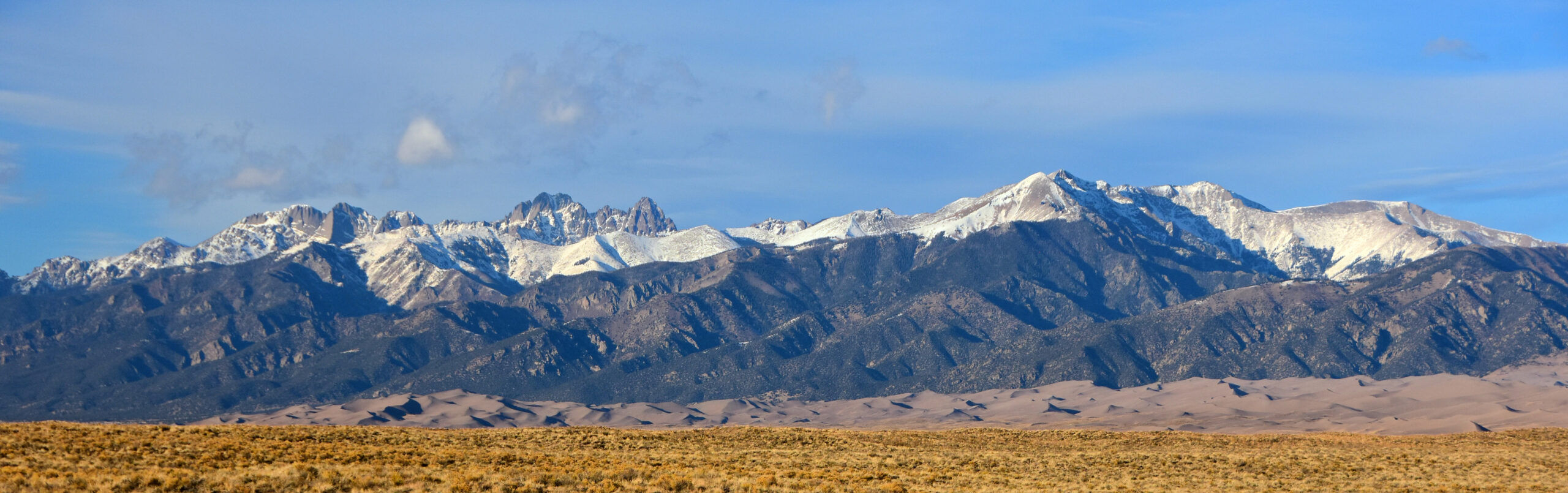
| Location | Sangre de Cristo Range, southern Colorado (Saguache / Custer county line) |
| Coordinates | 37.9668° N, 105.5853° W |
| Colorado rank | 7th-highest peak in Colorado |
| Range rank | 2nd in the Sangre de Cristo Range (after Blanca Peak, 14,345 ft) |
| Standard route | South Face via Broken Hand Pass & the Red Gully (Class 3, sustained) |
| Rock | Crestone Conglomerate – embedded-knob geology, unusually grippy |
| High camp | South Colony Lakes (~11,700 ft); ~5–6 miles from the trailhead |
| Round trip | ~12–14 miles · ~5,200 ft total gain (includes the Broken Hand Pass loss-and-regain) |
| Summit day | 8–12 hours from camp |
| Best season | Mid-July to mid-September (season runs late June to mid-October) |
| Permits / fees | None – free access, free wilderness camping |
| 2026 guided cost | ~$1,000–$2,500 per person (2–3 day program) |
| Wilderness | Sangre de Cristo Wilderness (designated 1993); RMFI trail stewardship |
Why Crestone Peak stands apart
Great rock, a wild setting, and a route longer than almost any other standard 14er.
Crestone Peak holds a precise place in Colorado climbing. It ranks below Colorado’s tallest 14er, Mount Elbert, and below Blanca Peak, the high point of its own range. What it owns is a reputation: among climbers who have done many fourteeners, Crestone Peak is simply “The Peak,” a byword for a long, sustained, beautiful Class 3 day on some of the best rock in the state. It was also one of the last major Colorado 14ers to be climbed, holding out until 1916, because early visitors thought its conglomerate walls had no reasonable route.
The Crestone Conglomerate
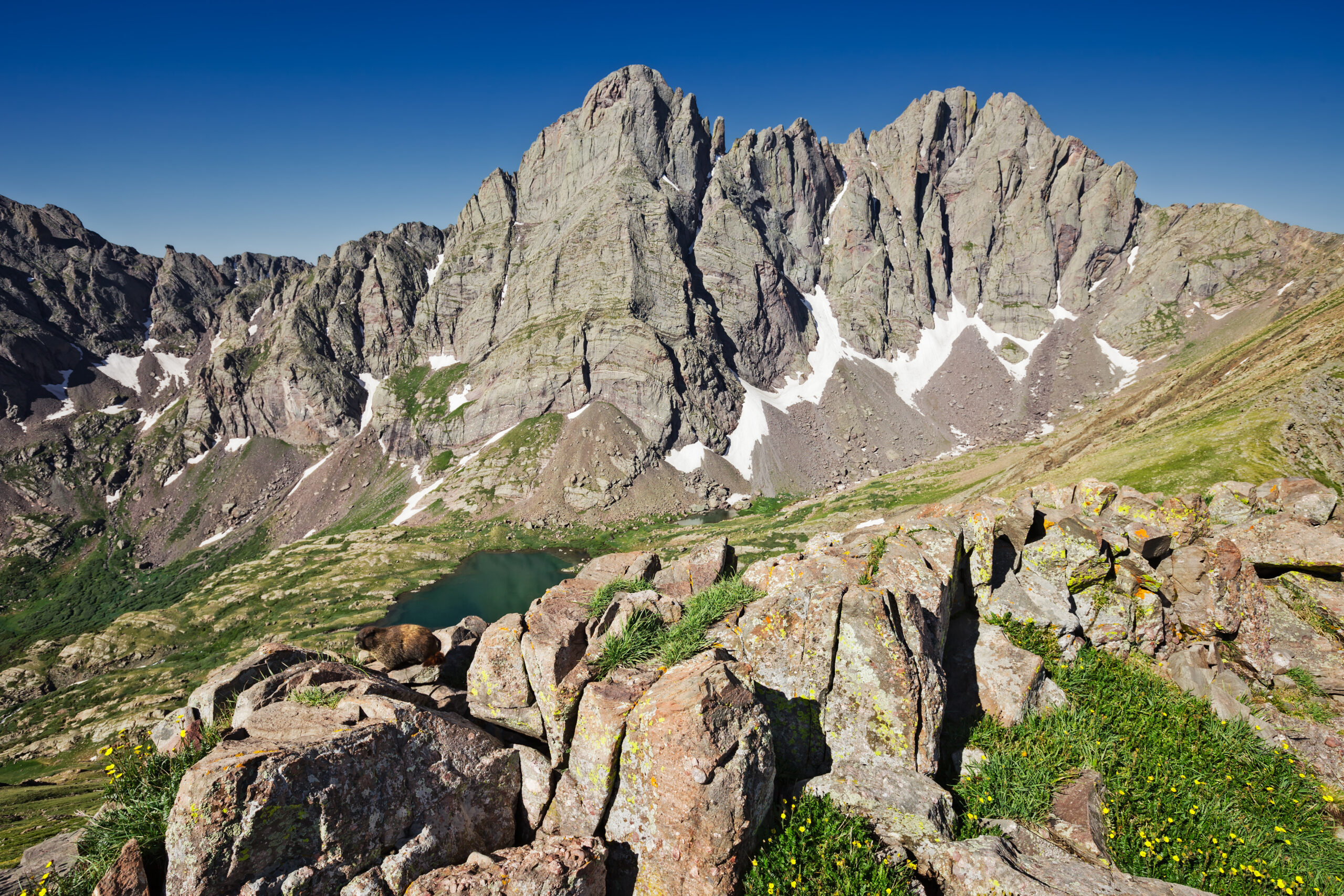
The Crestones owe their climbable reputation to their rock. Crestone Conglomerate is a hardened sedimentary rock studded with rounded stones roughly 2 to 6 inches across, embedded halfway out of the matrix. Those knobs act as positive hand and foot holds, so sustained Class 3 and 4 climbing works on walls that would be far more committing on smooth granite. Climbers routinely describe the rock as grippy and confidence-inspiring, and the effect is real enough that visiting climbers travel a long way to feel it. On 3,000-foot conglomerate walls, that grip is what makes the difference between a scramble and a serious technical climb.
The Red Gully
The route’s centerpiece is the Red Gully (also called the Red Couloir), a roughly 2,000-foot sustained Class 3 scramble that climbs the south face directly to a notch just below the summit. Unlike most Class 3 fourteeners, where the scrambling is brief and punctuated by walking, the Red Gully is continuous, steepening in two bands on the way to the notch. That sustained character – hundreds of feet of hands-on movement at over 13,000 ft – is what makes Crestone Peak climb harder than its Class 3 grade suggests, and why it’s such good training for the Class 4 peaks that follow.
Map & live weather
Crestone Peak sits deep in the Sangre de Cristo Wilderness above South Colony Lakes.
Summit: 14,294 ftBroken Hand Pass: ~12,900 ftHigh camp: South Colony Lakes (~11,700 ft)Trailhead: ~9,000 ft (2WD lot)
South Colony Lakes (~11,700 ft) – live forecast
Loading live data…
Fetching the latest forecast…
Live forecast unavailable right now. Check a Crestone Peak / South Colony Lakes mountain forecast before you go.
Basin weather, not summit weather. This forecast is for the South Colony Lakes basin (~11,700 ft). The summit at 14,294 ft is colder and windier, and Colorado’s summer monsoon builds afternoon thunderstorms most days – a pre-dawn start is the standard safety margin.
Who should climb it
More than most Class 3 14ers demand – be honest about scrambling endurance and exposure.
Crestone Peak sits above most Class 3 fourteeners but below true Class 4. Honest self-assessment matters here, especially about sustained scrambling stamina and comfort on prolonged exposure. It’s a strong fit if you:
| A good fit if you… | Not yet, if you… |
|---|---|
| Have two or three Class 3 14ers done (Sneffels, Wetterhorn, Longs) | Have no sustained Class 3 scrambling experience yet |
| Are building toward Class 4 peaks like Capitol Peak or the Maroon Bells | Want a drive-up trailhead – the 5–6 mile pack-in is non-negotiable |
| Are comfortable backpacking to an ~11,700 ft high camp | Are on a rigid schedule with no weather buffer |
| Want a sustained, aesthetic Sangres climb on superb rock | Struggle psychologically with prolonged exposure at altitude |
| Will commit to a pre-dawn start to beat the storms | Can’t commit to a 3–5am start during monsoon season |
Where it fits in your Colorado 14er progression
The standard step between the easy Class 3 peaks and the Class 4 hardest.
| Stage | Peak / experience | Difficulty |
|---|---|---|
| Foundation | Bierstadt, Sherman, Elbert | Class 1 walk-ups |
| Scrambles | Quandary, Massive, Grays | Class 2 |
| First Class 3 | Longs (Keyhole), Sneffels, Wetterhorn | Class 3, brief |
| The Crestone Peak step | Crestone Peak – South Face / Red Gully | Class 3 sustained |
| Class 4 fourteeners | Crestone Needle, Little Bear | Class 4 |
| The Crestone Traverse | Peak-to-Needle linkup | Class 5 (rope common) |
| Hardest 14ers | Capitol, Maroon, Pyramid | Class 4–5 |
The natural next step is Crestone Peak’s twin, Crestone Needle (Class 4) – many climbers do both from the same South Colony Lakes camp, either back-to-back or via the traverse. From there the Elk Range Class 4 peaks (Capitol, the Maroons, Pyramid) are the endgame; the sustained scrambling and long days you build on Crestone Peak transfer directly.
The routes
One standard line handles the vast majority – plus a snow route and a famous traverse.
| Route | Difficulty | Round trip | Who |
|---|---|---|---|
| South Face via Red Gully (standard) | Class 3 sustained | ~12–14 mi | ~90% of climbers |
| Northwest Couloir | Class 3–4 with snow | ~10–12 mi | Early-season snow climbers |
| Peak → Needle Traverse | Class 5 climbing | ~14–15 mi | Advanced only |
Route 1 — South Face via the Red Gully (standard)
The standard line climbs the south face via Broken Hand Pass and the Red Gully. Most parties break it into a 5-to-6-mile approach day to South Colony Lakes camp and a summit day of 8 to 12 hours; strong, fit climbers occasionally do the whole thing car-to-car in a single 14-to-18-hour push. The distinctive feature is the loss-and-regain: you climb to Broken Hand Pass, then lose 500 to 600 ft into Cottonwood Lake basin before the real climbing begins — elevation you have to earn back on the way home.
~9,000 ft
South Colony Lakes Trailhead
2WD lot off Custer County Road 119 (a rough 4WD road continues higher). Limited parking — arrive early on weekends.
11,700 ft
South Colony Lakes camp
5–6 miles in, ~4–5 hours with a full pack. Free dispersed wilderness camping in a spectacular basin below the Crestones.
12,900 ft
Broken Hand Pass
~1,200 ft of climbing to the saddle between Broken Hand Peak and Crestone Needle. Early season may hold a snowfield needing an ice axe.
12,300 ft
Cottonwood Lake basin
Descend 500–600 ft into the basin below the peak — the elevation you’ll regain on the return.
12,700 ft
Red Gully base
Follow cairns to the foot of the couloir. Water, food, and a mental gear-up before the sustained climbing.
14,100 ft
The notch
~2,000 ft of sustained Class 3 up the Red Gully on grippy conglomerate to the notch at the top of the couloir.
14,294 ft
Western summit
From the notch, scramble left up conglomerate ledges — a short, semi-exposed finish that can feel harder than the gully. The eastern summit (~30 ft lower) is a quick optional add-on.
Route 2 — Northwest Couloir (snow route)
An early-season alternative from the Crestone village side, best in May and June when consolidated snow fills the couloir for classic Colorado snow climbing. It needs crampons, an ice axe, and rope-team capability, and it melts out into loose, unpleasant talus by late summer. Most parties on it are experienced Colorado alpinists; guides rarely operate here.
Route 3 — Crestone Peak to Crestone Needle Traverse (advanced)
One of Colorado’s most famous 14er linkups: a half-mile of Class 5 climbing between the twin summits, usually taking 3 to 5 hours, with many parties roping up for the exposed sections. Most climbers summit Crestone Peak first, traverse to the Needle, then descend the Needle’s standard route. It rewards real rock-climbing competence, and it isn’t a place to learn it.
Know the true grade before you commitSome famous Crestones “tours” cross into alpine terrain — the Peak-to-Needle traverse is Class 5, and the Northwest Couloir is a snow climb. Read each route’s real grade, not just its reputation, and bring a rope and the skills where the route calls for them.
Summit day, hour by hour
From South Colony Lakes camp — one of the longest 14er summit days in the state.
04:00
Wake at camp (11,700 ft)
Typically 30–40°F even in summer. Quick breakfast, gear check, helmet on, headlamp ready.
04:30–05:00
Depart camp
Head up toward Broken Hand Pass. The morning’s main work is the climb to the pass.
05:00–07:00
Climb to Broken Hand Pass (12,900 ft)
~1,200 ft of gain; often the day’s most arduous stretch in the early dark. Sunrise usually lands here.
07:00–08:00
Descend to Cottonwood basin (12,300 ft)
Give back 500–600 ft — psychologically tough, since you’ll regain it later.
08:30–10:30
Red Gully (to ~14,100 ft)
~2,000 ft of sustained Class 3 on conglomerate. Positive holds throughout; steady, focused movement at altitude.
11:00–11:30
Western summit (14,294 ft)
Views across the Sangres to the Great Sand Dunes. Add the eastern summit if you like, then start down — the clock is now the enemy.
11:30–15:30
Descend to camp
Down-climb the gully (nearly as slow as the ascent), regain Broken Hand Pass, then drop to camp. Watch the sky — afternoon storms build fast.
Afternoon lightning is the real hazardColorado’s summer monsoon (mid-July through August) fires thunderstorms most days between about 11am and 2pm, and the Red Gully and summit are exposed lightning targets. Crestone Peak’s length makes timing unforgiving: if you’re not summiting by ~10:30–11:00, you’re descending exposed terrain into the danger window. The pre-dawn start is the margin that keeps you safe here — treat it as mandatory.
When to climb
Late June to mid-October, with a clear sweet spot.
Late June–early July: the Red Gully still holds snow; bring an ice axe and crampons, enjoy the best wildflowers and thinner crowds. Mid-July–mid-August: peak season — the gully is melted out and clean, but the monsoon is at its most aggressive, so pre-dawn starts are essential. Mid-August–mid-September: the sweet spot most experienced climbers prefer — excellent conditions, easing afternoon weather, thinner crowds. Mid-September–mid-October: stable autumn weather, golden aspens on the approach, cold starts, and the first summit snow late in the window. Winter is a serious mountaineering objective with real avalanche exposure in the gully and a road that closes by late October.
2026 costs
One of Colorado’s best-value big days — free to climb independently.
| Cost | 2026 (USD) | Notes |
|---|---|---|
| Forest / wilderness entry | $0 | No permits, no fees |
| Trailhead parking | $0 | Free; limited, arrive early |
| South Colony Lakes camping | $0 | Free dispersed wilderness camping |
| Lodging (Westcliffe / Crestone) | $80–$220/night | Small towns, limited options |
| Fuel + food | $30–$80/day | ~360 miles each way from Denver |
| Guided (2–3 day program) | $1,000–$2,500 pp | Peak-and-Needle programs at the top end |
Guided pricing runs higher per day than for drive-up 14ers because the backpacking approach, overnight high camp, and 12-to-14-mile length all add complexity, and few operators work the Sangres. If you want a guide, book 4–6 months ahead for summer dates.
Gear checklist
Backpacking kit for the camp plus scrambling kit for the gully.
| Category | Bring |
|---|---|
| Approach & camp | 60–75L pack, 3-season tent, bag rated to ~20°F, insulated pad, stove/fuel, water filter, WAG bags, bear canister or bag |
| Summit day | 25–35L daypack, helmet (required), sturdy boots, trekking poles for the loss-and-regain, gaiters for early-season snow |
| Clothing | Base layers, hiking pants, fleece/insulated mid-layer, warm insulated jacket, hardshell jacket + pants (storm protection is essential), hat, gloves |
| Safety & food | 3–4L water capacity, snacks/meals, sun protection, headlamp + spare batteries, first-aid, emergency bivy, map/compass or GPS, offline maps |
| Early season (May–early July) | Crampons, ice axe, and stiffer boots for the snow-filled couloir |
Leave No Trace in the SangresThe Crestones get steady trail-stewardship work from the Rocky Mountain Field Institute (RMFI). Stay on established trails, camp on durable surfaces at least 200 ft from water, and pack out all waste — WAG bags above treeline — to protect a heavily-used basin and the indigenous heritage of this range.
Frequently asked questions
How tall is Crestone Peak and where is it?
14,294 ft (4,357 m) in the Sangre de Cristo Range of southern Colorado — the 7th-highest peak in the state and 2nd in the range after Blanca Peak (14,345 ft). It has twin summits, the western being the high point (~30 ft above the eastern), and anchors the Crestone group with Crestone Needle, Kit Carson Peak, and Challenger Point.
How difficult is it?
Class 3 by grade, but harder than most Class 3 14ers because of length and sustained scrambling: ~1,200 ft to Broken Hand Pass, a 500–600 ft drop into Cottonwood basin, then ~2,000 ft of continuous Class 3 up the Red Gully. Round trip is ~12–14 miles with ~5,200 ft of gain — one of the longest standard 14er days in Colorado.
What’s the standard route?
The South Face via Broken Hand Pass and the Red Gully. From the South Colony Lakes Trailhead, hike ~5–6 miles to camp, climb to Broken Hand Pass, descend into Cottonwood basin, then scramble ~2,000 ft of sustained Class 3 up the Red Gully to a notch, and finish up conglomerate ledges to the summit.
What is the Crestone Conglomerate?
The rock the Crestones are built from — a hardened conglomerate with rounded 2–6 inch stones embedded halfway out, acting as positive holds. It’s unusually solid and grippy, which is why sustained Class 3–4 climbing is possible on walls that would otherwise be far more committing.
When is the best time to climb?
Mid-July to mid-September, within a late-June to mid-October season. The gully holds snow into early July (ice axe and crampons then). Because of the summer monsoon, start pre-dawn to summit and descend before afternoon thunderstorms.
How much does it cost in 2026?
Free to climb independently — no permits or fees, free camping. Budget for fuel, food, and lodging in Westcliffe or Crestone ($80–$220/night). Guided programs run ~$1,000–$2,500 per person for 2–3 days.
Can I climb Crestone Peak and Crestone Needle together?
Yes — a classic Sangres objective. Do them on consecutive days from South Colony Lakes camp (3–4 days total), or link them with the Class 5 Peak-to-Needle traverse, one of Colorado’s most famous 14er linkups. The traverse needs real rock-climbing skill and a rope for most parties.
How does it compare to Capitol Peak or the Maroon Bells?
It sits just below them — Class 3 sustained versus their Class 4 — and it’s excellent preparation. Capitol adds the committing Knife Edge on solid rock; the Maroons and Pyramid add loose, dangerous rock. A common order is Crestone Peak → Crestone Needle → the Elk Range Class 4 peaks.
How this guide is built
Research-based, cross-referenced with Colorado 14er field knowledge. Elevations, distances, route detail, and history are compiled from USGS survey data, 14ers.com, the Colorado Fourteeners Initiative, the Rocky Mountain Field Institute, and Forest Service sources. Figures are approximate and can differ between sources; feet are primary here, with metric in parentheses, for a US fourteener.
Trailhead access, road condition, snow level, RMFI stewardship status, and weather change every season and can differ on your dates. Confirm current conditions with the Forest Service, recent trip reports, and a current mountain forecast before you climb.
Walker Ludlow
Climber & Trail/Gear Research, Global Summit Guide
Walker researches Global Summit Guide’s US mountain and 14er coverage, focusing on route logistics, gear, and honest difficulty framing. This guide is research-based and cross-referenced with Colorado 14er field knowledge; safety and route content is reviewed by Dawson Ludlow. Our aim is to help climbers judge whether Crestone Peak matches their experience — because its Class 3 grade undersells how big a day it really is.
Plan your Colorado 14er climb
Colorado 14ers complete guide · Best mountains to climb in Colorado · Mount Sneffels · Capitol Peak · Blanca Peak · Longs Peak
Explore the mountain database
Browse all mountains · Filter the full mountain list · Which mountain should you climb? · Fitness standards
One of Colorado’s finest Class 3 days
Great rock, a wild Sangres setting, and a sustained Red Gully that punches above its grade. Come with the scrambling miles, the backpacking legs, and an early alarm — Crestone Peak rewards the prepared.Colorado 14ers guide →Next step: Capitol Peak →
🏔️ Colorado 14er · Sangre de Cristo Range · Class 3 · 2026
Crestone Peak: The Red Gully Route, Class 3 Difficulty & 2026 Guide
Colorado’s 7th-highest summit and one of its most demanding “non-technical” fourteeners – a 2,000-foot sustained Class 3 scramble up the famous Crestone Conglomerate. Here’s how to climb it, and who’s ready for it.
By Walker Ludlow · Trail & Route Research · Safety review: Dawson Ludlow
Updated July 12, 2026 · Last verified: July 12, 2026 · Reading time 11 minutes
Editorial approach: RESEARCH-BASED, cross-referenced with Colorado 14er field knowledge. Elevations, distances, and route detail are compiled from USGS data, 14ers.com, the Colorado Fourteeners Initiative, and Forest Service sources. Trailhead access, snow, and RMFI stewardship status change each season – verify current conditions before you go.
⚡ The short version
Crestone Peak is a Class 3 fourteener that climbs harder than its grade. The moves are Class 3, but the 2,000-foot Red Gully delivers more sustained scrambling than almost any other Class 3 14er, on top of a 12-to-14-mile day with a loss-and-regain over Broken Hand Pass. It feels closer to alpine climbing than a typical 14er hike.
The saving grace is the rock. The Crestone Conglomerate – embedded stones sticking out like natural holds – is famously grippy, which is exactly why sustained Class 3 is even possible here. Come with real Class 3 experience, backpacking legs for the South Colony Lakes approach, and a pre-dawn start to beat the storms.
14,294 ft
Summit (4,357 m) · 7th in CO
Class 3
Sustained · Red Gully
~5,200 ft
Gain · 12–14 mi round trip
1916
First ascent · Ellingwood & Davis
On this page
- At a glance
- Why it stands apart
- Map & live weather
- Who should climb it
- Where it fits in the progression
- The routes
- Summit day, hour by hour
- When to climb
- 2026 costs
- Gear checklist
- FAQ
Crestone Peak at a glance
The essential reference facts. Detail follows below.
| Summit elevation | 14,294 ft (4,357 m) – western summit; eastern summit ~30 ft lower |
| Location | Sangre de Cristo Range, southern Colorado (Saguache / Custer county line) |
| Coordinates | 37.9668° N, 105.5853° W |
| Colorado rank | 7th-highest peak in Colorado |
| Range rank | 2nd in the Sangre de Cristo Range (after Blanca Peak, 14,345 ft) |
| Standard route | South Face via Broken Hand Pass & the Red Gully (Class 3, sustained) |
| Rock | Crestone Conglomerate – embedded-knob geology, unusually grippy |
| High camp | South Colony Lakes (~11,700 ft); ~5–6 miles from the trailhead |
| Round trip | ~12–14 miles · ~5,200 ft total gain (includes the Broken Hand Pass loss-and-regain) |
| Summit day | 8–12 hours from camp |
| Best season | Mid-July to mid-September (season runs late June to mid-October) |
| Permits / fees | None – free access, free wilderness camping |
| 2026 guided cost | ~$1,000–$2,500 per person (2–3 day program) |
| Wilderness | Sangre de Cristo Wilderness (designated 1993); RMFI trail stewardship |
Why Crestone Peak stands apart
Great rock, a wild setting, and a route longer than almost any other standard 14er.
Crestone Peak holds a precise place in Colorado climbing. It ranks below Colorado’s tallest 14er, Mount Elbert, and below Blanca Peak, the high point of its own range. What it owns is a reputation: among climbers who have done many fourteeners, Crestone Peak is simply “The Peak,” a byword for a long, sustained, beautiful Class 3 day on some of the best rock in the state. It was also one of the last major Colorado 14ers to be climbed, holding out until 1916, because early visitors thought its conglomerate walls had no reasonable route.
The Crestone Conglomerate
The Crestones owe their climbable reputation to their rock. Crestone Conglomerate is a hardened sedimentary rock studded with rounded stones roughly 2 to 6 inches across, embedded halfway out of the matrix. Those knobs act as positive hand and foot holds, so sustained Class 3 and 4 climbing works on walls that would be far more committing on smooth granite. Climbers routinely describe the rock as grippy and confidence-inspiring, and the effect is real enough that visiting climbers travel a long way to feel it. On 3,000-foot conglomerate walls, that grip is what makes the difference between a scramble and a serious technical climb.
The Red Gully
The route’s centerpiece is the Red Gully (also called the Red Couloir), a roughly 2,000-foot sustained Class 3 scramble that climbs the south face directly to a notch just below the summit. Unlike most Class 3 fourteeners, where the scrambling is brief and punctuated by walking, the Red Gully is continuous, steepening in two bands on the way to the notch. That sustained character – hundreds of feet of hands-on movement at over 13,000 ft – is what makes Crestone Peak climb harder than its Class 3 grade suggests, and why it’s such good training for the Class 4 peaks that follow.
Map & live weather
Crestone Peak sits deep in the Sangre de Cristo Wilderness above South Colony Lakes.
Summit: 14,294 ftBroken Hand Pass: ~12,900 ftHigh camp: South Colony Lakes (~11,700 ft)Trailhead: ~9,000 ft (2WD lot)
South Colony Lakes (~11,700 ft) – live forecast
Loading live data…
Fetching the latest forecast…
Live forecast unavailable right now. Check a Crestone Peak / South Colony Lakes mountain forecast before you go.
Basin weather, not summit weather. This forecast is for the South Colony Lakes basin (~11,700 ft). The summit at 14,294 ft is colder and windier, and Colorado’s summer monsoon builds afternoon thunderstorms most days – a pre-dawn start is the standard safety margin.
Who should climb it
More than most Class 3 14ers demand – be honest about scrambling endurance and exposure.
Crestone Peak sits above most Class 3 fourteeners but below true Class 4. Honest self-assessment matters here, especially about sustained scrambling stamina and comfort on prolonged exposure. It’s a strong fit if you:
| A good fit if you… | Not yet, if you… |
|---|---|
| Have two or three Class 3 14ers done (Sneffels, Wetterhorn, Longs) | Have no sustained Class 3 scrambling experience yet |
| Are building toward Class 4 peaks like Capitol Peak or the Maroon Bells | Want a drive-up trailhead – the 5–6 mile pack-in is non-negotiable |
| Are comfortable backpacking to an ~11,700 ft high camp | Are on a rigid schedule with no weather buffer |
| Want a sustained, aesthetic Sangres climb on superb rock | Struggle psychologically with prolonged exposure at altitude |
| Will commit to a pre-dawn start to beat the storms | Can’t commit to a 3–5am start during monsoon season |
Where it fits in your Colorado 14er progression
The standard step between the easy Class 3 peaks and the Class 4 hardest.
| Stage | Peak / experience | Difficulty |
|---|---|---|
| Foundation | Bierstadt, Sherman, Elbert | Class 1 walk-ups |
| Scrambles | Quandary, Massive, Grays | Class 2 |
| First Class 3 | Longs (Keyhole), Sneffels, Wetterhorn | Class 3, brief |
| The Crestone Peak step | Crestone Peak – South Face / Red Gully | Class 3 sustained |
| Class 4 fourteeners | Crestone Needle, Little Bear | Class 4 |
| The Crestone Traverse | Peak-to-Needle linkup | Class 5 (rope common) |
| Hardest 14ers | Capitol, Maroon, Pyramid | Class 4–5 |
The natural next step is Crestone Peak’s twin, Crestone Needle (Class 4) – many climbers do both from the same South Colony Lakes camp, either back-to-back or via the traverse. From there the Elk Range Class 4 peaks (Capitol, the Maroons, Pyramid) are the endgame; the sustained scrambling and long days you build on Crestone Peak transfer directly.
The routes
One standard line handles the vast majority – plus a snow route and a famous traverse.
| Route | Difficulty | Round trip | Who |
|---|---|---|---|
| South Face via Red Gully (standard) | Class 3 sustained | ~12–14 mi | ~90% of climbers |
| Northwest Couloir | Class 3–4 with snow | ~10–12 mi | Early-season snow climbers |
| Peak → Needle Traverse | Class 5 climbing | ~14–15 mi | Advanced only |
Route 1 — South Face via the Red Gully (standard)
The standard line climbs the south face via Broken Hand Pass and the Red Gully. Most parties break it into a 5-to-6-mile approach day to South Colony Lakes camp and a summit day of 8 to 12 hours; strong, fit climbers occasionally do the whole thing car-to-car in a single 14-to-18-hour push. The distinctive feature is the loss-and-regain: you climb to Broken Hand Pass, then lose 500 to 600 ft into Cottonwood Lake basin before the real climbing begins — elevation you have to earn back on the way home.
~9,000 ft
South Colony Lakes Trailhead
2WD lot off Custer County Road 119 (a rough 4WD road continues higher). Limited parking — arrive early on weekends.
11,700 ft
South Colony Lakes camp
5–6 miles in, ~4–5 hours with a full pack. Free dispersed wilderness camping in a spectacular basin below the Crestones.
12,900 ft
Broken Hand Pass
~1,200 ft of climbing to the saddle between Broken Hand Peak and Crestone Needle. Early season may hold a snowfield needing an ice axe.
12,300 ft
Cottonwood Lake basin
Descend 500–600 ft into the basin below the peak — the elevation you’ll regain on the return.
12,700 ft
Red Gully base
Follow cairns to the foot of the couloir. Water, food, and a mental gear-up before the sustained climbing.
14,100 ft
The notch
~2,000 ft of sustained Class 3 up the Red Gully on grippy conglomerate to the notch at the top of the couloir.
14,294 ft
Western summit
From the notch, scramble left up conglomerate ledges — a short, semi-exposed finish that can feel harder than the gully. The eastern summit (~30 ft lower) is a quick optional add-on.
Route 2 — Northwest Couloir (snow route)
An early-season alternative from the Crestone village side, best in May and June when consolidated snow fills the couloir for classic Colorado snow climbing. It needs crampons, an ice axe, and rope-team capability, and it melts out into loose, unpleasant talus by late summer. Most parties on it are experienced Colorado alpinists; guides rarely operate here.
Route 3 — Crestone Peak to Crestone Needle Traverse (advanced)
One of Colorado’s most famous 14er linkups: a half-mile of Class 5 climbing between the twin summits, usually taking 3 to 5 hours, with many parties roping up for the exposed sections. Most climbers summit Crestone Peak first, traverse to the Needle, then descend the Needle’s standard route. It rewards real rock-climbing competence, and it isn’t a place to learn it.
Know the true grade before you commitSome famous Crestones “tours” cross into alpine terrain — the Peak-to-Needle traverse is Class 5, and the Northwest Couloir is a snow climb. Read each route’s real grade, not just its reputation, and bring a rope and the skills where the route calls for them.
Summit day, hour by hour
From South Colony Lakes camp — one of the longest 14er summit days in the state.
04:00
Wake at camp (11,700 ft)
Typically 30–40°F even in summer. Quick breakfast, gear check, helmet on, headlamp ready.
04:30–05:00
Depart camp
Head up toward Broken Hand Pass. The morning’s main work is the climb to the pass.
05:00–07:00
Climb to Broken Hand Pass (12,900 ft)
~1,200 ft of gain; often the day’s most arduous stretch in the early dark. Sunrise usually lands here.
07:00–08:00
Descend to Cottonwood basin (12,300 ft)
Give back 500–600 ft — psychologically tough, since you’ll regain it later.
08:30–10:30
Red Gully (to ~14,100 ft)
~2,000 ft of sustained Class 3 on conglomerate. Positive holds throughout; steady, focused movement at altitude.
11:00–11:30
Western summit (14,294 ft)
Views across the Sangres to the Great Sand Dunes. Add the eastern summit if you like, then start down — the clock is now the enemy.
11:30–15:30
Descend to camp
Down-climb the gully (nearly as slow as the ascent), regain Broken Hand Pass, then drop to camp. Watch the sky — afternoon storms build fast.
Afternoon lightning is the real hazardColorado’s summer monsoon (mid-July through August) fires thunderstorms most days between about 11am and 2pm, and the Red Gully and summit are exposed lightning targets. Crestone Peak’s length makes timing unforgiving: if you’re not summiting by ~10:30–11:00, you’re descending exposed terrain into the danger window. The pre-dawn start is the margin that keeps you safe here — treat it as mandatory.
When to climb
Late June to mid-October, with a clear sweet spot.
Late June–early July: the Red Gully still holds snow; bring an ice axe and crampons, enjoy the best wildflowers and thinner crowds. Mid-July–mid-August: peak season — the gully is melted out and clean, but the monsoon is at its most aggressive, so pre-dawn starts are essential. Mid-August–mid-September: the sweet spot most experienced climbers prefer — excellent conditions, easing afternoon weather, thinner crowds. Mid-September–mid-October: stable autumn weather, golden aspens on the approach, cold starts, and the first summit snow late in the window. Winter is a serious mountaineering objective with real avalanche exposure in the gully and a road that closes by late October.
2026 costs
One of Colorado’s best-value big days — free to climb independently.
| Cost | 2026 (USD) | Notes |
|---|---|---|
| Forest / wilderness entry | $0 | No permits, no fees |
| Trailhead parking | $0 | Free; limited, arrive early |
| South Colony Lakes camping | $0 | Free dispersed wilderness camping |
| Lodging (Westcliffe / Crestone) | $80–$220/night | Small towns, limited options |
| Fuel + food | $30–$80/day | ~360 miles each way from Denver |
| Guided (2–3 day program) | $1,000–$2,500 pp | Peak-and-Needle programs at the top end |
Guided pricing runs higher per day than for drive-up 14ers because the backpacking approach, overnight high camp, and 12-to-14-mile length all add complexity, and few operators work the Sangres. If you want a guide, book 4–6 months ahead for summer dates.
Gear checklist
Backpacking kit for the camp plus scrambling kit for the gully.
| Category | Bring |
|---|---|
| Approach & camp | 60–75L pack, 3-season tent, bag rated to ~20°F, insulated pad, stove/fuel, water filter, WAG bags, bear canister or bag |
| Summit day | 25–35L daypack, helmet (required), sturdy boots, trekking poles for the loss-and-regain, gaiters for early-season snow |
| Clothing | Base layers, hiking pants, fleece/insulated mid-layer, warm insulated jacket, hardshell jacket + pants (storm protection is essential), hat, gloves |
| Safety & food | 3–4L water capacity, snacks/meals, sun protection, headlamp + spare batteries, first-aid, emergency bivy, map/compass or GPS, offline maps |
| Early season (May–early July) | Crampons, ice axe, and stiffer boots for the snow-filled couloir |
Leave No Trace in the SangresThe Crestones get steady trail-stewardship work from the Rocky Mountain Field Institute (RMFI). Stay on established trails, camp on durable surfaces at least 200 ft from water, and pack out all waste — WAG bags above treeline — to protect a heavily-used basin and the indigenous heritage of this range.
Frequently asked questions
How tall is Crestone Peak and where is it?
14,294 ft (4,357 m) in the Sangre de Cristo Range of southern Colorado — the 7th-highest peak in the state and 2nd in the range after Blanca Peak (14,345 ft). It has twin summits, the western being the high point (~30 ft above the eastern), and anchors the Crestone group with Crestone Needle, Kit Carson Peak, and Challenger Point.
How difficult is it?
Class 3 by grade, but harder than most Class 3 14ers because of length and sustained scrambling: ~1,200 ft to Broken Hand Pass, a 500–600 ft drop into Cottonwood basin, then ~2,000 ft of continuous Class 3 up the Red Gully. Round trip is ~12–14 miles with ~5,200 ft of gain — one of the longest standard 14er days in Colorado.
What’s the standard route?
The South Face via Broken Hand Pass and the Red Gully. From the South Colony Lakes Trailhead, hike ~5–6 miles to camp, climb to Broken Hand Pass, descend into Cottonwood basin, then scramble ~2,000 ft of sustained Class 3 up the Red Gully to a notch, and finish up conglomerate ledges to the summit.
What is the Crestone Conglomerate?
The rock the Crestones are built from — a hardened conglomerate with rounded 2–6 inch stones embedded halfway out, acting as positive holds. It’s unusually solid and grippy, which is why sustained Class 3–4 climbing is possible on walls that would otherwise be far more committing.
When is the best time to climb?
Mid-July to mid-September, within a late-June to mid-October season. The gully holds snow into early July (ice axe and crampons then). Because of the summer monsoon, start pre-dawn to summit and descend before afternoon thunderstorms.
How much does it cost in 2026?
Free to climb independently — no permits or fees, free camping. Budget for fuel, food, and lodging in Westcliffe or Crestone ($80–$220/night). Guided programs run ~$1,000–$2,500 per person for 2–3 days.
Can I climb Crestone Peak and Crestone Needle together?
Yes — a classic Sangres objective. Do them on consecutive days from South Colony Lakes camp (3–4 days total), or link them with the Class 5 Peak-to-Needle traverse, one of Colorado’s most famous 14er linkups. The traverse needs real rock-climbing skill and a rope for most parties.
How does it compare to Capitol Peak or the Maroon Bells?
It sits just below them — Class 3 sustained versus their Class 4 — and it’s excellent preparation. Capitol adds the committing Knife Edge on solid rock; the Maroons and Pyramid add loose, dangerous rock. A common order is Crestone Peak → Crestone Needle → the Elk Range Class 4 peaks.
How this guide is built
Research-based, cross-referenced with Colorado 14er field knowledge. Elevations, distances, route detail, and history are compiled from USGS survey data, 14ers.com, the Colorado Fourteeners Initiative, the Rocky Mountain Field Institute, and Forest Service sources. Figures are approximate and can differ between sources; feet are primary here, with metric in parentheses, for a US fourteener.
Trailhead access, road condition, snow level, RMFI stewardship status, and weather change every season and can differ on your dates. Confirm current conditions with the Forest Service, recent trip reports, and a current mountain forecast before you climb.
Walker Ludlow
Climber & Trail/Gear Research, Global Summit Guide
Walker researches Global Summit Guide’s US mountain and 14er coverage, focusing on route logistics, gear, and honest difficulty framing. This guide is research-based and cross-referenced with Colorado 14er field knowledge; safety and route content is reviewed by Dawson Ludlow. Our aim is to help climbers judge whether Crestone Peak matches their experience — because its Class 3 grade undersells how big a day it really is.
Plan your Colorado 14er climb
Colorado 14ers complete guide · Best mountains to climb in Colorado · Mount Sneffels · Capitol Peak · Blanca Peak · Longs Peak
Explore the mountain database
Browse all mountains · Filter the full mountain list · Which mountain should you climb? · Fitness standards
One of Colorado’s finest Class 3 days
Great rock, a wild Sangres setting, and a sustained Red Gully that punches above its grade. Come with the scrambling miles, the backpacking legs, and an early alarm — Crestone Peak rewards the prepared.Colorado 14ers guide →Next step: Capitol Peak →
Crestone Peak: The Red Gully Route, Class 3 Difficulty & 2026 Guide
Colorado’s 7th-highest summit and one of its most demanding “non-technical” fourteeners – a 2,000-foot sustained Class 3 scramble up the famous Crestone Conglomerate. Here’s how to climb it, and who’s ready for it.
Crestone Peak is a Class 3 fourteener that climbs harder than its grade. The moves are Class 3, but the 2,000-foot Red Gully delivers more sustained scrambling than almost any other Class 3 14er, on top of a 12-to-14-mile day with a loss-and-regain over Broken Hand Pass. It feels closer to alpine climbing than a typical 14er hike.
The saving grace is the rock. The Crestone Conglomerate – embedded stones sticking out like natural holds – is famously grippy, which is exactly why sustained Class 3 is even possible here. Come with real Class 3 experience, backpacking legs for the South Colony Lakes approach, and a pre-dawn start to beat the storms.
On this page
Crestone Peak at a glance
The essential reference facts. Detail follows below.
| Summit elevation | 14,294 ft (4,357 m) – western summit; eastern summit ~30 ft lower |
| Location | Sangre de Cristo Range, southern Colorado (Saguache / Custer county line) |
| Coordinates | 37.9668° N, 105.5853° W |
| Colorado rank | 7th-highest peak in Colorado |
| Range rank | 2nd in the Sangre de Cristo Range (after Blanca Peak, 14,345 ft) |
| Standard route | South Face via Broken Hand Pass & the Red Gully (Class 3, sustained) |
| Rock | Crestone Conglomerate – embedded-knob geology, unusually grippy |
| High camp | South Colony Lakes (~11,700 ft); ~5–6 miles from the trailhead |
| Round trip | ~12–14 miles · ~5,200 ft total gain (includes the Broken Hand Pass loss-and-regain) |
| Summit day | 8–12 hours from camp |
| Best season | Mid-July to mid-September (season runs late June to mid-October) |
| Permits / fees | None – free access, free wilderness camping |
| 2026 guided cost | ~$1,000–$2,500 per person (2–3 day program) |
| Wilderness | Sangre de Cristo Wilderness (designated 1993); RMFI trail stewardship |
Why Crestone Peak stands apart
Great rock, a wild setting, and a route longer than almost any other standard 14er.
Crestone Peak holds a precise place in Colorado climbing. It ranks below Colorado’s tallest 14er, Mount Elbert, and below Blanca Peak, the high point of its own range. What it owns is a reputation: among climbers who have done many fourteeners, Crestone Peak is simply “The Peak,” a byword for a long, sustained, beautiful Class 3 day on some of the best rock in the state. It was also one of the last major Colorado 14ers to be climbed, holding out until 1916, because early visitors thought its conglomerate walls had no reasonable route.
The Crestone Conglomerate
The Crestones owe their climbable reputation to their rock. Crestone Conglomerate is a hardened sedimentary rock studded with rounded stones roughly 2 to 6 inches across, embedded halfway out of the matrix. Those knobs act as positive hand and foot holds, so sustained Class 3 and 4 climbing works on walls that would be far more committing on smooth granite. Climbers routinely describe the rock as grippy and confidence-inspiring, and the effect is real enough that visiting climbers travel a long way to feel it. On 3,000-foot conglomerate walls, that grip is what makes the difference between a scramble and a serious technical climb.
The Red Gully
The route’s centerpiece is the Red Gully (also called the Red Couloir), a roughly 2,000-foot sustained Class 3 scramble that climbs the south face directly to a notch just below the summit. Unlike most Class 3 fourteeners, where the scrambling is brief and punctuated by walking, the Red Gully is continuous, steepening in two bands on the way to the notch. That sustained character – hundreds of feet of hands-on movement at over 13,000 ft – is what makes Crestone Peak climb harder than its Class 3 grade suggests, and why it’s such good training for the Class 4 peaks that follow.
Map & live weather
Crestone Peak sits deep in the Sangre de Cristo Wilderness above South Colony Lakes.
South Colony Lakes (~11,700 ft) – live forecast
Loading live data…Who should climb it
More than most Class 3 14ers demand – be honest about scrambling endurance and exposure.
Crestone Peak sits above most Class 3 fourteeners but below true Class 4. Honest self-assessment matters here, especially about sustained scrambling stamina and comfort on prolonged exposure. It’s a strong fit if you:
| A good fit if you… | Not yet, if you… |
|---|---|
| Have two or three Class 3 14ers done (Sneffels, Wetterhorn, Longs) | Have no sustained Class 3 scrambling experience yet |
| Are building toward Class 4 peaks like Capitol Peak or the Maroon Bells | Want a drive-up trailhead – the 5–6 mile pack-in is non-negotiable |
| Are comfortable backpacking to an ~11,700 ft high camp | Are on a rigid schedule with no weather buffer |
| Want a sustained, aesthetic Sangres climb on superb rock | Struggle psychologically with prolonged exposure at altitude |
| Will commit to a pre-dawn start to beat the storms | Can’t commit to a 3–5am start during monsoon season |
Where it fits in your Colorado 14er progression
The standard step between the easy Class 3 peaks and the Class 4 hardest.
| Stage | Peak / experience | Difficulty |
|---|---|---|
| Foundation | Bierstadt, Sherman, Elbert | Class 1 walk-ups |
| Scrambles | Quandary, Massive, Grays | Class 2 |
| First Class 3 | Longs (Keyhole), Sneffels, Wetterhorn | Class 3, brief |
| The Crestone Peak step | Crestone Peak – South Face / Red Gully | Class 3 sustained |
| Class 4 fourteeners | Crestone Needle, Little Bear | Class 4 |
| The Crestone Traverse | Peak-to-Needle linkup | Class 5 (rope common) |
| Hardest 14ers | Capitol, Maroon, Pyramid | Class 4–5 |
The natural next step is Crestone Peak’s twin, Crestone Needle (Class 4) – many climbers do both from the same South Colony Lakes camp, either back-to-back or via the traverse. From there the Elk Range Class 4 peaks (Capitol, the Maroons, Pyramid) are the endgame; the sustained scrambling and long days you build on Crestone Peak transfer directly.
The routes
One standard line handles the vast majority – plus a snow route and a famous traverse.
| Route | Difficulty | Round trip | Who |
|---|---|---|---|
| South Face via Red Gully (standard) | Class 3 sustained | ~12–14 mi | ~90% of climbers |
| Northwest Couloir | Class 3–4 with snow | ~10–12 mi | Early-season snow climbers |
| Peak → Needle Traverse | Class 5 climbing | ~14–15 mi | Advanced only |
Route 1 — South Face via the Red Gully (standard)
The standard line climbs the south face via Broken Hand Pass and the Red Gully. Most parties break it into a 5-to-6-mile approach day to South Colony Lakes camp and a summit day of 8 to 12 hours; strong, fit climbers occasionally do the whole thing car-to-car in a single 14-to-18-hour push. The distinctive feature is the loss-and-regain: you climb to Broken Hand Pass, then lose 500 to 600 ft into Cottonwood Lake basin before the real climbing begins — elevation you have to earn back on the way home.
2WD lot off Custer County Road 119 (a rough 4WD road continues higher). Limited parking — arrive early on weekends.
5–6 miles in, ~4–5 hours with a full pack. Free dispersed wilderness camping in a spectacular basin below the Crestones.
~1,200 ft of climbing to the saddle between Broken Hand Peak and Crestone Needle. Early season may hold a snowfield needing an ice axe.
Descend 500–600 ft into the basin below the peak — the elevation you’ll regain on the return.
Follow cairns to the foot of the couloir. Water, food, and a mental gear-up before the sustained climbing.
~2,000 ft of sustained Class 3 up the Red Gully on grippy conglomerate to the notch at the top of the couloir.
From the notch, scramble left up conglomerate ledges — a short, semi-exposed finish that can feel harder than the gully. The eastern summit (~30 ft lower) is a quick optional add-on.
Route 2 — Northwest Couloir (snow route)
An early-season alternative from the Crestone village side, best in May and June when consolidated snow fills the couloir for classic Colorado snow climbing. It needs crampons, an ice axe, and rope-team capability, and it melts out into loose, unpleasant talus by late summer. Most parties on it are experienced Colorado alpinists; guides rarely operate here.
Route 3 — Crestone Peak to Crestone Needle Traverse (advanced)
One of Colorado’s most famous 14er linkups: a half-mile of Class 5 climbing between the twin summits, usually taking 3 to 5 hours, with many parties roping up for the exposed sections. Most climbers summit Crestone Peak first, traverse to the Needle, then descend the Needle’s standard route. It rewards real rock-climbing competence, and it isn’t a place to learn it.
Summit day, hour by hour
From South Colony Lakes camp — one of the longest 14er summit days in the state.
Typically 30–40°F even in summer. Quick breakfast, gear check, helmet on, headlamp ready.
Head up toward Broken Hand Pass. The morning’s main work is the climb to the pass.
~1,200 ft of gain; often the day’s most arduous stretch in the early dark. Sunrise usually lands here.
Give back 500–600 ft — psychologically tough, since you’ll regain it later.
~2,000 ft of sustained Class 3 on conglomerate. Positive holds throughout; steady, focused movement at altitude.
Views across the Sangres to the Great Sand Dunes. Add the eastern summit if you like, then start down — the clock is now the enemy.
Down-climb the gully (nearly as slow as the ascent), regain Broken Hand Pass, then drop to camp. Watch the sky — afternoon storms build fast.
When to climb
Late June to mid-October, with a clear sweet spot.
Late June–early July: the Red Gully still holds snow; bring an ice axe and crampons, enjoy the best wildflowers and thinner crowds. Mid-July–mid-August: peak season — the gully is melted out and clean, but the monsoon is at its most aggressive, so pre-dawn starts are essential. Mid-August–mid-September: the sweet spot most experienced climbers prefer — excellent conditions, easing afternoon weather, thinner crowds. Mid-September–mid-October: stable autumn weather, golden aspens on the approach, cold starts, and the first summit snow late in the window. Winter is a serious mountaineering objective with real avalanche exposure in the gully and a road that closes by late October.
2026 costs
One of Colorado’s best-value big days — free to climb independently.
| Cost | 2026 (USD) | Notes |
|---|---|---|
| Forest / wilderness entry | $0 | No permits, no fees |
| Trailhead parking | $0 | Free; limited, arrive early |
| South Colony Lakes camping | $0 | Free dispersed wilderness camping |
| Lodging (Westcliffe / Crestone) | $80–$220/night | Small towns, limited options |
| Fuel + food | $30–$80/day | ~360 miles each way from Denver |
| Guided (2–3 day program) | $1,000–$2,500 pp | Peak-and-Needle programs at the top end |
Guided pricing runs higher per day than for drive-up 14ers because the backpacking approach, overnight high camp, and 12-to-14-mile length all add complexity, and few operators work the Sangres. If you want a guide, book 4–6 months ahead for summer dates.
Gear checklist
Backpacking kit for the camp plus scrambling kit for the gully.
| Category | Bring |
|---|---|
| Approach & camp | 60–75L pack, 3-season tent, bag rated to ~20°F, insulated pad, stove/fuel, water filter, WAG bags, bear canister or bag |
| Summit day | 25–35L daypack, helmet (required), sturdy boots, trekking poles for the loss-and-regain, gaiters for early-season snow |
| Clothing | Base layers, hiking pants, fleece/insulated mid-layer, warm insulated jacket, hardshell jacket + pants (storm protection is essential), hat, gloves |
| Safety & food | 3–4L water capacity, snacks/meals, sun protection, headlamp + spare batteries, first-aid, emergency bivy, map/compass or GPS, offline maps |
| Early season (May–early July) | Crampons, ice axe, and stiffer boots for the snow-filled couloir |
Frequently asked questions
How tall is Crestone Peak and where is it?
14,294 ft (4,357 m) in the Sangre de Cristo Range of southern Colorado — the 7th-highest peak in the state and 2nd in the range after Blanca Peak (14,345 ft). It has twin summits, the western being the high point (~30 ft above the eastern), and anchors the Crestone group with Crestone Needle, Kit Carson Peak, and Challenger Point.
How difficult is it?
Class 3 by grade, but harder than most Class 3 14ers because of length and sustained scrambling: ~1,200 ft to Broken Hand Pass, a 500–600 ft drop into Cottonwood basin, then ~2,000 ft of continuous Class 3 up the Red Gully. Round trip is ~12–14 miles with ~5,200 ft of gain — one of the longest standard 14er days in Colorado.
What’s the standard route?
The South Face via Broken Hand Pass and the Red Gully. From the South Colony Lakes Trailhead, hike ~5–6 miles to camp, climb to Broken Hand Pass, descend into Cottonwood basin, then scramble ~2,000 ft of sustained Class 3 up the Red Gully to a notch, and finish up conglomerate ledges to the summit.
What is the Crestone Conglomerate?
The rock the Crestones are built from — a hardened conglomerate with rounded 2–6 inch stones embedded halfway out, acting as positive holds. It’s unusually solid and grippy, which is why sustained Class 3–4 climbing is possible on walls that would otherwise be far more committing.
When is the best time to climb?
Mid-July to mid-September, within a late-June to mid-October season. The gully holds snow into early July (ice axe and crampons then). Because of the summer monsoon, start pre-dawn to summit and descend before afternoon thunderstorms.
How much does it cost in 2026?
Free to climb independently — no permits or fees, free camping. Budget for fuel, food, and lodging in Westcliffe or Crestone ($80–$220/night). Guided programs run ~$1,000–$2,500 per person for 2–3 days.
Can I climb Crestone Peak and Crestone Needle together?
Yes — a classic Sangres objective. Do them on consecutive days from South Colony Lakes camp (3–4 days total), or link them with the Class 5 Peak-to-Needle traverse, one of Colorado’s most famous 14er linkups. The traverse needs real rock-climbing skill and a rope for most parties.
How does it compare to Capitol Peak or the Maroon Bells?
It sits just below them — Class 3 sustained versus their Class 4 — and it’s excellent preparation. Capitol adds the committing Knife Edge on solid rock; the Maroons and Pyramid add loose, dangerous rock. A common order is Crestone Peak → Crestone Needle → the Elk Range Class 4 peaks.
How this guide is built
Research-based, cross-referenced with Colorado 14er field knowledge. Elevations, distances, route detail, and history are compiled from USGS survey data, 14ers.com, the Colorado Fourteeners Initiative, the Rocky Mountain Field Institute, and Forest Service sources. Figures are approximate and can differ between sources; feet are primary here, with metric in parentheses, for a US fourteener.
Trailhead access, road condition, snow level, RMFI stewardship status, and weather change every season and can differ on your dates. Confirm current conditions with the Forest Service, recent trip reports, and a current mountain forecast before you climb.
One of Colorado’s finest Class 3 days
Great rock, a wild Sangres setting, and a sustained Red Gully that punches above its grade. Come with the scrambling miles, the backpacking legs, and an early alarm — Crestone Peak rewards the prepared.
Colorado 14ers guide → Next step: Capitol Peak →Was this helpful?
🏔Related peaks nearby
🧭Explore & compare
Global Summit Guide is an independent mountaineering resource founded in 2026. The team combines first-hand trekking and climbing experience with in-depth research and professional health and nutrition review to help climbers choose objectives, prepare properly, and stay safe.
Health, altitude, and nutrition content is reviewed by Taylor Ludlow (Registered Nurse) and Brigg Hoopes (Nutritionist).
What We Don't Know Yet
Mountain information changes quickly. This box explains the limits of what this page can responsibly promise.
- Permit availability, reservation windows, quotas, and official fee rules may change after this page is updated.
- Weather, snowpack, avalanche risk, road access, and route conditions can change quickly and may be different on your climbing dates.
- Route conditions, trailhead access, crevasse exposure, stream crossings, and rescue access may vary from published planning guidance.
- Total trip cost can change with flights, lodging, guide pricing, permits, gear rentals, transportation, and exchange rates.
- Gear requirements can change by season, route variation, weather window, personal cold tolerance, and guide-service requirements.
Verify current conditions with official land managers, guide services, local forecasts, and current route reports before booking or climbing.
Part of this Global Summit Guide cluster
Explore the complete Mountains guide for more context, routes, planning links, and related resources.
Mountaineering, rock and ice climbing, glacier travel, and high-altitude activity are inherently dangerous and can result in serious injury or death. The information on Global Summit Guide is provided for general informational and educational purposes only and is not a substitute for professional instruction, qualified guiding, proper equipment, or your own judgment and experience.
Route conditions, weather, snowpack, permits, regulations, and hazards change constantly and may differ from what is described here. Details may be incomplete, out of date, or contain errors. Always verify current information with local authorities, certified guides, and official sources before making any decision in the mountains.
Nothing on this site is medical, legal, or financial advice. Our fitness, acclimatization, altitude, and nutrition content is general in nature; consult a qualified physician before beginning any strenuous exercise program or exposing yourself to high altitude.
You are solely responsible for your own safety and decisions. To the fullest extent permitted by law, Global Summit Guide and its team accept no liability for any loss, injury, damage, or expense arising from use of, or reliance on, this information. By using this site you acknowledge these risks and accept these terms.
Some links on this site may be affiliate links. If you buy through them we may earn a small commission at no extra cost to you; this never affects our recommendations.
Global Summit Guide recommendation path
Next Best Mountain to Research
Use these recommendations to continue the right planning path instead of stopping on one page.
Use current permit, weather, route, and operator information before booking or climbing.