
Last updated June 16, 2026
Climbing Mount Sneffels 2026: Colorado’s Most Photographed 14er, the Yankee Boy Basin Route & Southwest Ridge
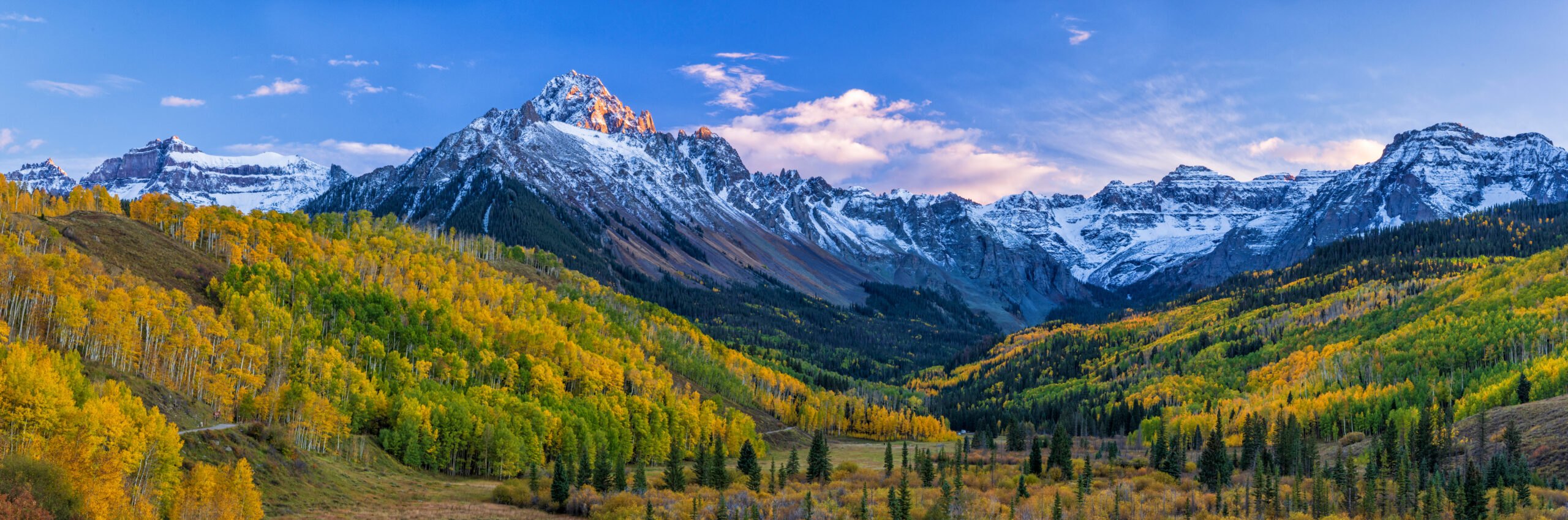
At 14,158 feet, Mount Sneffels rises above the wildflower meadows of Yankee Boy Basin as one of the most photographed peaks in Colorado. The standard Lavender Couloir route climbs through loose scree to a notch and Class 3 scrambling to the summit. The Southwest Ridge offers sustained Class 3 with significant exposure. The complete 2026 climbing guide.
Notably, Mount Sneffels occupies a specific position in Colorado mountaineering that few other 14ers share. The peak isn’t the tallest in the state — Mount Elbert claims that title at 14,440 feet. It isn’t the most famous — Longs Peak and Pikes Peak hold those reputations. What Sneffels has, uniquely, is photogenic perfection. The mountain rises sharply above the Yankee Boy Basin wildflower meadows in the San Juan Mountains, presenting a profile that has appeared on Colorado tourism brochures, calendars, and screensavers for decades. It’s the peak you’ve seen in dozens of photographs without ever knowing its name.
At 14,158 feet (4,315 meters), Sneffels is the 27th highest peak in Colorado and the highest summit in the Sneffels Range, a sub-range of the San Juans. The standard Lavender Couloir route from Yankee Boy Basin is Class 3 — a meaningful step up from the Class 1-2 walk-ups that characterize easier Colorado fourteeners. The route climbs through loose scree, ascends a steep couloir filled with what climbers call “ball-bearing” rocks, and finishes with technical scrambling through a notch to the summit. Total elevation gain is approximately 2,100 feet over 2.5-3 miles round trip. Most parties complete the climb in 4-6 hours, with afternoon thunderstorm timing as the critical factor in determining safety.
The mountain’s name has a small literary footnote. Mount Sneffels was named after Snæfell, the Icelandic volcano featured in Jules Verne’s Journey to the Center of the Earth (1864). When the Hayden Survey expedition reached the peak in 1874, the rugged volcanic appearance reminded the surveyors of Verne’s description of Snæfell. The name stuck. Most climbers reaching the summit today have no idea they’re standing on a 19th-century literary reference. But the connection makes Sneffels distinctive — one of the few Colorado fourteeners with a name rooted in Romantic-era European literature rather than a person, indigenous term, or geographic feature.
Find Hotels, Flights & Trips for the World’s Best Hiking Destinations
The Global Summit Guide Travel Shop on Expedia — curated for outdoor adventurers, mountaineers, and serious hikers. Patagonia to the Alps. Nepal to the Rockies. Curated lodging for every region we cover.
Explore Travel Shop on Expedia →This guide covers what you need to climb Sneffels in 2026. The standard Lavender Couloir route in full detail. The Class 3 Southwest Ridge alternative with significant exposure. Yankee Boy Basin road access requirements (4×4 high-clearance vehicle for upper trailhead). Gear, season analysis, the critical timing of thunderstorm avoidance, and where Sneffels fits in the broader Colorado 14er progression. Plus the cultural and historical context that makes this peak distinctive among Colorado climbing objectives.
Mount Sneffels At a Glance
The essential reference facts for Mount Sneffels. Detailed sections follow below.
| Summit elevation | 14,158 ft (4,315 m) — current NAVD88; sometimes listed as 14,150 ft using older measurements |
|---|---|
| Location | Mount Sneffels Wilderness, Uncompahgre National Forest, Colorado, USA |
| Coordinates | 37.9954°N, 107.7917°W |
| Mountain range | Sneffels Range, San Juan Mountains, Colorado Rockies |
| Ranking | 27th highest peak in Colorado; 51st highest in North America |
| Highest in | Sneffels Range (highest peak in this San Juan sub-range) |
| Wilderness designation | Mount Sneffels Wilderness Area (1980); 16,500 acres |
| Name origin | Named after Snæfell, an Icelandic volcano in Jules Verne’s Journey to the Center of the Earth (1864) |
| First recorded ascent | September 10, 1874 — Hayden Survey expedition (Franklin Rhoda, A.D. Wilson, W.H. Holmes) |
| Standard route | Lavender Couloir from Yankee Boy Basin (Class 3) |
| Alternative routes | Southwest Ridge (sustained Class 3), Snake Couloir (AI 2-3 with Class 5.5) |
| Trailhead | Yankee Boy Basin upper trailhead (~12,460 ft) accessed via Yankee Boy Basin Road from Ouray |
| Round trip distance | 2.5-3 miles from upper trailhead |
| Total elevation gain | ~2,100 feet (640 m) |
| Typical round-trip time | 4-6 hours for most climbers |
| Best season | Mid-July through mid-September; June and October are shoulder seasons |
| Required equipment | Helmet, sturdy boots, trekking poles, layered clothing, plenty of water |
| Permits required | None — free access in Uncompahgre National Forest |
| Vehicle access | 4×4 high-clearance required for upper Yankee Boy Basin trailhead; 2WD vehicles park lower (adds ~3 miles) |
| Gateway town | Ouray, Colorado — 10 miles from Yankee Boy Basin trailhead |
| Nearest major airport | Montrose Regional (MTJ) — 45 minutes; Telluride (TEX) — 1 hour |
The literary footnote. Mount Sneffels carries one of the more unusual name origins among Colorado’s fourteeners. When the Hayden Survey expedition first ascended the peak on September 10, 1874, surveyor Franklin Rhoda noted that the dramatic, rugged peak reminded him of the Icelandic volcano Snæfell. Snæfell was described in Jules Verne’s Journey to the Center of the Earth, a novel published just a decade earlier in 1864. The name stuck. Today, most climbers reaching the summit have no idea they’re standing atop a 19th-century literary reference. The peak is one of only a handful of fourteeners with a name rooted in European Romantic literature rather than indigenous languages, geographic features, or surveyor honorifics.
Why Mount Sneffels Earns Its Place Among Colorado’s Iconic 14ers
Sneffels stands apart from most Colorado fourteeners in a way that’s hard to capture in words but immediately obvious in person. The peak combines four elements that rarely converge. Photogenic geometry. Technical content that exceeds beginner walk-ups without crossing into expert territory. Exceptional alpine setting through Yankee Boy Basin’s wildflower meadows. And the cultural depth of being one of Colorado’s most painted, photographed, and recognized peaks. Here’s why it earns its reputation.
The Pyramid Profile
From the right angles — particularly from the upper Yankee Boy Basin parking area and the trail through the lower meadows — Mount Sneffels presents a near-perfect pyramid form. The mountain’s geological structure (a steep, glacially-carved peak with three distinct ridgelines) creates a profile that photographers describe as Matterhorn-esque. The comparison is generous, but the visual impact is real. Sneffels has become the de facto symbol of San Juan mountaineering precisely because the peak photographs so well from accessible viewpoints. Calendar photographers and Colorado tourism boards have long since recognized this — Sneffels appears on more Colorado magazine covers and tourism materials than any other 14er.
Real Class 3 Climbing, Not a Walk-Up
Most Colorado fourteeners climbed by general hikers are Class 1 walk-ups (Mount Elbert, Quandary, Bierstadt) or Class 2 scrambles (Longs Peak’s Keyhole Route). Sneffels delivers genuine Class 3 climbing — loose scree, a steep couloir, and a final scramble through a notch and to the summit. This makes Sneffels a meaningful step up for climbers who’ve completed the easier 14ers and want technical content without committing to expert-only objectives like Capitol Peak, the Maroon Bells, or the Crestones. The Southwest Ridge alternative adds further technical difficulty with sustained Class 3 climbing and significant exposure.
Yankee Boy Basin’s Wildflower Spectacle
The approach through Yankee Boy Basin is itself one of Colorado’s signature alpine experiences. From mid-July through August, the basin transforms into one of the most spectacular wildflower displays in the state. Columbine, Indian paintbrush, alpine sunflower, lupine, and dozens of other species blanket the meadows. The basin sits at 11,000-12,500 feet — the perfect elevation band for the Colorado alpine bloom. Many climbers report that the approach matters as much as the summit itself. Photographers often plan trips specifically for the late-July to early-August window when wildflower density peaks beneath the dramatic Sneffels backdrop.
The San Juan Setting
Mount Sneffels anchors one of the most scenically dramatic ranges in the United States. The San Juans differ from the Front Range or Sawatch ranges in their geological complexity — heavily mineralized volcanic terrain creates the dramatic colors and rugged profiles that distinguish the range. Climbers staying in Ouray (called the “Switzerland of America”) for their Sneffels attempt can access additional San Juan classics. These include the famous Black Bear Pass jeep road, the Million Dollar Highway scenic drive, and nearby fourteeners like Wilson Peak, Mount Wilson, El Diente, and Wetterhorn. A Sneffels trip integrates naturally with broader San Juan exploration.
Why Sneffels appears in so many photographs. Three factors combine to make Sneffels one of Colorado’s most-photographed peaks. First, the dramatic pyramid profile from accessible viewpoints (Dallas Divide, Yankee Boy Basin, certain points along the Million Dollar Highway). Second, the wildflower foregrounds that frame the peak during peak summer. Third, the seasonal color of the surrounding aspen groves in late September, which transforms the lower slopes into gold-orange tapestries while the peak retains its dark volcanic profile above. Photographers visiting Telluride or Ouray for fall colors invariably include Sneffels in their portfolios. Climbers who summit Sneffels join a long tradition of artists, photographers, and visitors who’ve found the peak’s geometry irresistible.
Who Should Climb Mount Sneffels?
Sneffels sits in a specific middle ground in Colorado 14er difficulty. It’s harder than beginner walk-ups but easier than expert technical climbs. Honest self-assessment matters here, particularly regarding scrambling experience and comfort on loose terrain with exposure.
Sneffels Is Appropriate For:
Climbers progressing from easier 14ers. If you’ve completed Class 1-2 fourteeners (Elbert, Bierstadt, Quandary, Sherman, Massive) and want to step up to Class 3 climbing, Sneffels is the standard recommendation. The technical demands exceed walk-up peaks but remain achievable for fit climbers with prior 14er experience.
Scramblers comfortable with loose rock. The Lavender Couloir route involves significant loose scree and “ball-bearing” rocks on the descent. Climbers comfortable with three-points-of-contact movement on unstable terrain perform better than those who default to walking technique.
Photographers and outdoor enthusiasts. Few Colorado climbs offer the scenic richness of Sneffels and Yankee Boy Basin. Photographers wanting both the climb and the iconic basin scenery in a single trip find the package compelling.
Climbers visiting Ouray or Telluride. Sneffels integrates naturally with San Juan exploration. Many climbers attempt the peak as part of a longer Colorado mountain trip that includes other 14ers, scenic drives, and cultural visits to Ouray or Telluride.
Climbers building toward harder Colorado peaks. Sneffels serves as ideal preparation for harder Class 3-4 fourteeners like Capitol Peak, the Maroon Bells traverse, Pyramid Peak, or the Crestones. The skills and exposure tolerance transfer directly.
Cardio-fit hikers with limited high-altitude experience. The trailhead at 12,460 feet means the actual climb only gains 2,100 feet — much less than 14ers starting at lower elevations. Strong hikers can complete Sneffels with less altitude exposure than peaks like Longs Peak (which gains 4,800 feet from a 9,400-foot trailhead).
Sneffels Is Not Appropriate For:
First-time 14er climbers. The Class 3 demands exceed what most beginners can safely handle. Complete two or three Class 1-2 fourteeners first before attempting Sneffels.
Climbers uncomfortable with loose rock and exposure. The Lavender Couloir’s descent through loose scree is consistently described as more difficult than the ascent. Climbers prone to slipping or struggling with unstable terrain should choose easier objectives.
Climbers in 2WD vehicles unwilling to walk extra miles. The upper Yankee Boy Basin trailhead requires 4×4 high-clearance access. 2WD vehicles park 2-3 miles below, adding significant approach time. Climbers without proper vehicles should plan accordingly.
Climbers attempting summit during afternoon storms. Colorado’s monsoon afternoon thunderstorms (July-August) create lightning risk on exposed ridges and summits. Climbers who can’t commit to pre-dawn starts and morning summits face genuinely dangerous conditions.
Winter mountaineers without alpine experience. Sneffels in winter becomes a serious technical mountaineering objective requiring full alpine equipment and avalanche assessment skills. Casual winter ascents are not appropriate.
Where Sneffels Fits in Your Colorado 14er Progression
| Stage | Peak / Experience | Difficulty | What it builds |
|---|---|---|---|
| Foundation | Mount Bierstadt, Mount Sherman, Mount Elbert | Class 1 walk-ups | Altitude exposure, basic 14er fitness, expedition rhythm |
| Class 2 scrambles | Quandary Peak, Mount Massive, Grays Peak | Class 2 | Off-trail navigation, talus hopping, weather assessment |
| The Class 2-3 step | Longs Peak Keyhole, Mount of the Holy Cross | Class 2-3 | First exposure to genuine scrambling and exposure |
| The Sneffels step | Mount Sneffels Lavender Couloir or SW Ridge | Class 3 | Loose rock skill, couloir climbing, helmet-required terrain |
| Class 3+ challenges | Wetterhorn, Crestone Needle, Little Bear Peak | Class 3-4 | Sustained scrambling, route-finding, advanced exposure |
| Expert 14ers | Capitol Peak, Maroon Bells traverse, Pyramid Peak | Class 4-5 | Technical climbing, rope skills, advanced alpine judgment |
| Beyond Colorado | Mount Rainier, Grand Teton, Bolivian/Andean peaks | Glaciated alpine | Crampons, ice axe, glacier travel |
| International mountaineering | Aconcagua, Denali, Himalayan peaks | Expedition climbing | Where Colorado 14er skills validate higher objectives |
The Standard Routes Up Mount Sneffels
Three established routes lead to the Mount Sneffels summit. The Lavender Couloir from Yankee Boy Basin handles roughly 85% of climbers. The Southwest Ridge attracts climbers wanting more technical content. The Snake Couloir is a serious winter and shoulder-season mountaineering objective. Here’s the breakdown of each.
| Route | Aspect | Difficulty | Typical Time | Usage |
|---|---|---|---|---|
| Lavender Couloir (Standard) | South Slopes | Class 3 | 4-6 hours RT | ~85% of climbers |
| Southwest Ridge | Southwest | Sustained Class 3 | 5-7 hours RT | ~10% of climbers |
| Snake Couloir | North face | AI 2-3 with Class 5.5 | 6-10 hours | Winter/shoulder season only |
Route 1: The Lavender Couloir from Yankee Boy Basin (Standard)
The Lavender Couloir is the standard route on Mount Sneffels and the recommended route for most climbers. Named after early Colorado mountaineer Dwight Lavender, who climbed extensively in the San Juans, the route ascends from the upper Yankee Boy Basin trailhead. It traverses the South Slopes and enters the prominent couloir on the southeast side of the mountain. The route involves real scrambling — loose scree on the lower slopes, a steep couloir with significant rockfall potential, and a final notch with exposed Class 3 climbing to the summit. This is not a walk-up, but it remains achievable for fit climbers with prior 14er experience.
The Route Breakdown
- Upper Yankee Boy Basin Trailhead (12,460 ft): Start point requires 4×4 high-clearance vehicle to reach. 2WD vehicles park lower (adding 2-3 miles to the round trip). Composting toilet available at the trailhead.
- Lower trail to Blue Lakes junction (~12,800 ft): Initial 0.4 miles on well-defined trail through high alpine meadows. Wildflowers spectacular in July-August. Junction with Blue Lakes Trail leading to alternative routes.
- South Slopes ascent (12,800-13,500 ft): Steeper trail climbing approximately 750 feet in 0.5 miles. Loose scree begins. Hiking poles helpful for descent.
- Sneffels-Kismet Saddle (~13,500 ft): Reach the saddle between Sneffels and the smaller Kismet peak. Wear helmets from this point.
- Lavender Couloir entrance (13,500-13,900 ft): The prominent gully on the south face. Significant loose rock. Rockfall hazard from climbers above is real — stay close to the team and announce loose rocks.
- The notch and final scramble (13,900-14,100 ft): Climb through a small notch using Class 3 scrambling. This is the route’s technical crux. The final 100 feet involves exposed scrambling to the summit.
- Summit (14,158 ft): Small platform with 360° San Juan views. Wilson Peak, Mount Wilson, El Diente visible to the southwest. The town of Ouray visible far below.
- Descent: Reverse the route. The descent of the loose scree is consistently described as more difficult than the ascent. Be cautious of “marbles” — small round stones on hard-packed slopes that act like ball bearings.
Strengths
- Highest trailhead access of any Colorado 14er (12,460 ft)
- Short total distance (2.5-3 miles round trip)
- Spectacular wildflower approach in summer
- Excellent Class 3 introduction without expert exposure
- Well-marked trail to the saddle
Considerations
- 4×4 vehicle required for upper trailhead
- Loose scree descent is genuinely difficult
- Rockfall hazard in the couloir from climbers above
- Significant exposure at the summit notch
- Afternoon thunderstorm timing is critical
Route 2: The Southwest Ridge (Class 3 alternative)
The Southwest Ridge offers a more sustained Class 3 alternative to the Lavender Couloir. Climbers reach the ridge from Blue Lakes Pass (accessible from either Yankee Boy Basin or the Blue Lakes Trailhead). The ridge climbs directly to the summit with sustained exposure on both sides. The terrain is consistently rated more committing than the Lavender Couloir. The exposure is greater and the climbing is more sustained. However, the technical grade remains Class 3 rather than crossing into Class 4. Many climbers ascend via the Lavender Couloir and descend via the Southwest Ridge (or vice versa) to make a partial loop.
Strengths
- More technical content than standard route
- Less crowded than the Lavender Couloir
- Sustained ridge climbing experience
- Can be combined with standard route as loop
- Better for climbers preparing for harder 14ers
Considerations
- Significant exposure on both sides of the ridge
- Sustained Class 3 demands consistent focus
- Loose rock throughout the ridge
- Longer total time than Lavender Couloir
- Not appropriate for first Class 3 attempt
Route 3: The Snake Couloir (Winter/Shoulder Season)
The Snake Couloir is a serious mountaineering objective on Mount Sneffels’ north face. Approached from Blaine Basin, the route climbs a steep snow couloir at more than 45 degrees with sections of even steeper ice. The final 100 feet involves Class 5 climbing on rock to reach the summit. The route is best climbed in late spring (May-June) when the snow is consolidated and stable, or in winter conditions for experienced ice climbers. The Snake Couloir is not appropriate for summer climbing as the snow conditions deteriorate. This is a true alpine objective requiring crampons, ice axe, rope work, and avalanche assessment skills. Most parties descend via the standard Lavender Couloir route after summiting.
Mount Sneffels Climbing History: From 1874 to 2026
Long before any recorded European or American climbing activity, the Ute people held the San Juan Mountains as part of their ancestral territory. The Tabeguache band of the Northern Ute maintained extensive knowledge of the region, including the dramatic peak now called Sneffels. Indigenous understanding of the mountain — its weather patterns, alpine plant uses, and seasonal access — preceded any climbing literature by centuries. The Ute were forced from the region following gold and silver discoveries in the San Juans during the 1870s mining boom.
French novelist Jules Verne published Voyage au centre de la Terre (translated as Journey to the Center of the Earth) in 1864. The novel describes a scientific expedition descending into a hollow Earth through the volcanic crater of Snæfell in Iceland. The book became one of the most popular adventure novels of the 19th century, widely read by educated Americans and Europeans alike. The novel’s influence would shape the naming of a Colorado peak just ten years later.
The first recorded ascent of Mount Sneffels was completed by members of the Hayden Geological Survey on September 10, 1874. The summit party included Franklin Rhoda, Alfred D. Wilson, and William H. Holmes. Rhoda’s account in the official survey report described the dramatic, rugged volcanic appearance of the peak. The name “Sneffels” — anglicized from the Icelandic Snæfell — was applied to the mountain in reference to Jules Verne’s novel published just a decade earlier. The naming made Sneffels one of the few Colorado fourteeners with a literary origin rather than an indigenous or surveyor honorific name.
The 1870s San Juan mining boom transformed the area around Mount Sneffels. The town of Sneffels was established at approximately 11,000 feet in Yankee Boy Basin, supporting nearby silver and gold mining operations. The Camp Bird Mine, Atlas Mill, and other operations brought thousands of miners and infrastructure to the area. Climbing the peak during this era was incidental — miners and surveyors occasionally summited as part of their work rather than as a recreational objective.
The 1893 silver crash devastated San Juan mining. The town of Sneffels gradually emptied. By the early 20th century, the mining operations had largely ceased, leaving the basin to nature. Recreational climbing in the San Juans began emerging during this period, though Mount Sneffels remained relatively obscure compared to peaks closer to Denver and the Front Range. The peak’s location in the remote San Juan Mountains kept climbing volume modest through the early 20th century.
Through the 1930s and 1940s, Colorado mountaineer Dwight Lavender climbed extensively in the San Juans, including multiple ascents of Mount Sneffels. The Lavender Couloir — now the standard route on Sneffels — was named after Dwight Lavender’s frequent ascents of the line. Lavender’s documentation of San Juan climbing established the foundation for modern route-finding on the peak. His climbing records remained the standard reference for decades afterward.
Congress designated the Mount Sneffels Wilderness Area in 1980 under the Colorado Wilderness Act. The designation protected 16,500 acres surrounding the peak, including Yankee Boy Basin and Blue Lakes Basin. The wilderness designation brought stricter access rules but preserved the mountain’s character. The Wilderness Area continues to serve as one of the most protected climbing zones in the Colorado Rockies.
The 1990s and 2000s saw rapid growth in Colorado 14er climbing as a recreational pursuit. Lists, guidebooks, and online resources (14ers.com launched in 2001) drove tens of thousands of climbers to attempt all 54-58 Colorado peaks above 14,000 feet. Mount Sneffels emerged as one of the most popular Class 3 objectives, with climbing volume growing considerably through the 2000s. Yankee Boy Basin parking became increasingly competitive during peak season.
The Colorado Fourteeners Initiative (CFI) and Forest Service partnered on major trail improvements through the 2010s. The Yankee Boy Basin road received maintenance to preserve access while protecting the fragile alpine environment. Sneffels’ fragile summit area received attention to prevent erosion from increased climbing traffic. Volunteer crews installed cairns and trail signs to keep climbers on the standard route and reduce off-trail damage to the wilderness.
The 2020 COVID-19 pandemic dramatically affected Colorado 14er climbing. The combination of urban Coloradans seeking outdoor recreation and restricted travel options caused trailhead crowding on popular peaks including Sneffels. Yankee Boy Basin parking filled before sunrise on weekends. Trail conditions deteriorated under high traffic. Recreational management measures expanded through 2021-2022 to handle the volume.
The 2023-2025 climbing seasons saw continued strong demand for Mount Sneffels. Yankee Boy Basin road access remains the limiting factor — the upper trailhead’s 4×4 requirement caps daily summit numbers. The 2026 season is currently active with prime conditions running from late June through mid-October. Climate-related changes affect the climbing season slightly — earlier snowmelt opens the route a few weeks earlier than historical norms, but afternoon monsoon storms remain a constant summer concern.
Yankee Boy Basin Road Access: What You Need to Know
Vehicle access to the upper Yankee Boy Basin trailhead is the single most important logistical consideration for Mount Sneffels climbers. The condition of the road, your vehicle capability, and your willingness to walk extra distance directly affect total trip time and difficulty.
The Road from Ouray
From Ouray, drive south on US 550 for 0.5 miles, then turn west onto Colorado 361 (Camp Bird Road). The road climbs through dramatic switchbacks past the Camp Bird Mine area. At approximately 7 miles, you’ll reach the old town of Sneffels (now mostly abandoned mining ruins). The road continues to deteriorate above the town. Standard 2WD vehicles can reach approximately 11,000-11,400 feet under typical conditions, with most parking at the lower trailhead. The road from this point to the upper trailhead requires 4WD high-clearance.
4×4 High-Clearance Section
Above the old Sneffels townsite, the road becomes a serious 4×4 jeep trail. Climbers without proper 4×4 high-clearance vehicles should park at the lower trailhead and walk approximately 2-3 miles to the upper trailhead, adding 600-900 feet of elevation gain. Jeeps, properly equipped trucks, and high-clearance SUVs (typically with at least 8 inches of ground clearance and 4WD/AWD) can reach the upper trailhead at approximately 12,460 feet. The final mile or two genuinely requires confident 4×4 driving — climbers attempting it in marginal vehicles often turn back before reaching the upper trailhead.
Parking and Access Tips
| Trailhead | Elevation | Vehicle Required | Notes |
|---|---|---|---|
| Lower Yankee Boy Basin | ~10,800 ft | 2WD adequate | Standard cars; adds 4-5 miles to total RT |
| Below Wright’s Lake | ~11,200 ft | AWD with clearance | Many SUVs reach this point; adds 3 miles RT |
| Restroom Trailhead | ~11,800 ft | 4WD light SUV | Composting toilet here; adds 1 mile RT |
| Upper Trailhead | 12,460 ft | 4WD high-clearance | True jeeps and capable trucks; standard distance |
Don’t drive what you can’t handle back down. The Yankee Boy Basin road has caught out many drivers in marginal vehicles. The descent on loose rock with poor brakes or insufficient ground clearance is more dangerous than the ascent. If you’re uncertain about your vehicle’s capability, park lower and walk the extra miles. Towing a vehicle out of the upper basin costs hundreds of dollars and takes hours. Plan trailhead access realistically rather than optimistically.
Mount Sneffels Summit Day Timeline: Hour-by-Hour
Summit day on Mount Sneffels typically runs 4-6 hours round trip from the upper Yankee Boy Basin trailhead. The single most important timing consideration is afternoon thunderstorm avoidance during summer monsoon season (mid-July through August). Most climbers start before sunrise to be off the summit by 10:00-11:00. Here’s the standard timeline for a summer ascent.
Standard Mount Sneffels Summit Day — Upper Yankee Boy Basin (12,460 ft) to Summit (14,158 ft) and Return
Why pre-dawn starts matter on Sneffels. Colorado afternoon thunderstorms during the summer monsoon (mid-July through August) develop rapidly between 11:00 and 14:00, bringing lightning, hail, and dangerous conditions on exposed peaks. Climbers on the Sneffels summit or in the Lavender Couloir during a storm face serious lightning risk. The 04:00 wake-up isn’t optional discipline — it’s the standard safety margin that lets you summit and start descending by 10:00. Climbers still climbing at noon during monsoon season face genuinely dangerous conditions. Check the forecast carefully, and turn around early if storms are building.
Which Sneffels Approach Fits Your Situation?
The choice on Mount Sneffels involves route selection, vehicle access, and timing. Use this matrix to match yourself to the right approach.
Match Yourself to a Mount Sneffels Approach
When to Climb Mount Sneffels: Season-by-Season Analysis
Mid-June to Early July: Early Season
The Sneffels climbing season opens as snow melts from the standard route. Mid-June ascents may still encounter significant snow in the Lavender Couloir. Yankee Boy Basin Road typically opens by late May or early June. Wildflowers begin appearing in mid-June. Crowds are lower than peak summer. Some climbers prefer this window for cooler temperatures and quieter trails.
Mid-July to Mid-August: Peak Season
The prime Sneffels climbing window. Yankee Boy Basin’s wildflower bloom peaks during this period — the basin transforms into one of Colorado’s most spectacular alpine displays. Weather is warmest. The trade-off: afternoon thunderstorms are most aggressive during the summer monsoon. Pre-dawn starts are essential. Trailhead parking fills before sunrise on weekends. This window also brings the highest concentration of climbers — expect company on the route.
Mid-August to Mid-September: Late Summer
Conditions remain excellent through late summer with slightly less aggressive afternoon weather as monsoon season ends. Wildflowers transition to late-season varieties. Crowds decline noticeably from peak season. Many climbers consider this an optimal window — same trail conditions, fewer people, more predictable weather.
Mid-September to Mid-October: Autumn
The autumn window brings stable weather, golden aspen colors in the lower basin, and significantly reduced crowds. Photographers favor this period for the combined climb-and-color experience. Temperatures drop noticeably — start with warmer layers than summer. Early October may bring first snow on the summit. The climbing remains achievable but conditions transition rapidly toward winter.
October to Mid-June: Off-Season
Winter ascents of Mount Sneffels become serious mountaineering objectives requiring full alpine equipment and avalanche assessment skills. Yankee Boy Basin Road closes to vehicles in winter (typically late October through May). The standard route becomes far more committing under snow. The Snake Couloir on the north face becomes a viable winter mountaineering line. Climbers attempting Sneffels in winter need extensive alpine experience.
Climbing Mount Sneffels in 2026: Cost Breakdown
Mount Sneffels is one of the most affordable major climbing objectives in Colorado. The combination of free access, no permits, and short trip duration makes the per-summit cost minimal for climbers with their own vehicle and basic gear.
Independent Climbing Costs
| Cost Component | 2026 Amount (USD) | Notes |
|---|---|---|
| Forest Service / Wilderness Area entry | $0 | Free access; no permits required |
| Yankee Boy Basin Road access | $0 | Free parking; no fees |
| Ouray accommodation (per night, summer) | $120-$350 | Hotels and inns; book 4-8 weeks ahead for peak season |
| Vacation rental in Ouray (per night) | $150-$500 | For 2-4 person groups |
| Camping (Amphitheater Campground or nearby) | $20-$40 | Forest Service campgrounds; reservations recommended |
| Meals (Ouray restaurants) | $60-$150/day | Casual to mid-range dining |
| Fuel (Denver to Ouray round trip) | $80-$140 | ~340 miles each way; depends on vehicle MPG |
| Vehicle rental (if needed) | $80-$200/day | 4×4 high-clearance vehicles for upper trailhead |
| Personal gear | $0-$500 | If you don’t already have boots, helmet, layers, etc. |
| Total 2-3 day independent budget | $400-$1,200 | Excluding international travel and existing gear |
Guided Expedition Costs
| Operator Program | 2026 Cost (USD) | What’s Included |
|---|---|---|
| Single-day guided ascent (private) | $400-$600 per person | Certified Colorado guide, group size 1:2 to 1:4, gear assistance |
| Two-day Sneffels program (private guiding) | $700-$1,100 per person | Acclimatization day, instruction, comfortable summit attempt timing |
| San Juan 14ers cluster (3-5 day) | $1,200-$2,500 per person | Sneffels + Wetterhorn, Uncompahgre, or Wilson Peak combination |
| Photography-focused programs | $400-$800 per person/day | Slower pace, multiple photography stops, specialized guides |
How Sneffels compares to other 14ers. The cost per summit for Mount Sneffels is among the lowest of any major Colorado climbing objective. Most independent climbers complete a Sneffels trip for $400-$800 including 2 nights in Ouray, fuel, and meals — considerably less than a comparable trip to a Front Range 14er from out of state. Guided programs are also less common and less expensive than for technical objectives like Capitol Peak or the Maroon Bells. For climbers seeking high-quality 14er experiences at modest cost, Sneffels delivers exceptional value alongside its scenic and cultural significance.
Gear Checklist for Mount Sneffels
Mount Sneffels gear requirements sit between trekking and mountaineering. The Class 3 standard route demands proper scrambling kit but doesn’t require full alpine equipment in summer conditions. Winter ascents are a different category entirely with full alpine gear required.
Summer Climbing Essentials
- Sturdy hiking boots — high-cut leather or synthetic boots with aggressive lugs; trail runners are inadequate for the loose scree
- Helmet — required from the saddle upward; rockfall hazard real in the Lavender Couloir
- Trekking poles — essential for the loose scree descent
- Gaiters — short gaiters keep scree out of boots
- 30-40L backpack — enough for layers, food, water, helmet stowage on lower approach
- Sunglasses (Cat 3-4) — UV at 14,000 feet is intense
Clothing System
- Base layer top — merino or synthetic; pre-dawn temperatures can be near-freezing
- Hiking pants — quick-drying synthetic; jeans are inappropriate
- Mid-layer fleece or light insulated jacket — for cool starts and summit stops
- Hardshell jacket — for wind on the summit and sudden weather changes; Gore-Tex or equivalent
- Hat (warm) — for pre-dawn and summit
- Sun hat or visor — UV protection during the climb
- Light gloves — for the rocky sections and cool morning starts
Food, Water, and Safety
- Water — at least 2-3 liters — no reliable water sources on the climb above the saddle
- Energy food — bars, gels, trail mix; eat throughout the climb
- Snacks for the summit and descent
- Sunscreen SPF 30+ and lip balm with SPF — UV exposure severe
- Personal first aid kit — blister care, ibuprofen, basic supplies
- Headlamp with spare batteries — essential for pre-dawn drive and any unexpected delays
- Emergency bivy or space blanket — for unexpected weather or injury
- Phone with offline maps — Yankee Boy Basin has limited cell service
- Cash or card — for Ouray meals and gas
Vehicle Considerations
- 4×4 high-clearance vehicle — for upper trailhead access
- Spare tire and basic tools — Yankee Boy Basin road can puncture tires
- Recovery gear if traveling alone — basic recovery strap minimum
- Full fuel tank from Ouray — no gas stations beyond town
Winter / Shoulder Season Additional Gear
- Crampons — for snow and ice on the upper route — see our Crampons Buyer’s Guide
- Ice axe — straight-shaft mountaineering axe — see our Ice Axe Guide
- Avalanche safety gear — beacon, probe, shovel for backcountry winter travel
- Mountaineering boots (B2-B3) — required for crampon use
- Heavy insulated layers — temperatures can drop below -10°F at the summit
- Climbing rope and harness — for the Snake Couloir route
Frequently Asked Questions About Climbing Mount Sneffels
How tall is Mount Sneffels and where is it located?
Mount Sneffels rises to 14,158 feet (4,315 meters) in the San Juan Mountains of southwestern Colorado, near the town of Ouray. The coordinates are 37.9954°N, 107.7917°W. The summit elevation is sometimes listed as 14,150 feet using older measurements; current NAVD88 surveys put the peak at 14,158 feet. Mount Sneffels is the 27th highest peak in Colorado, the 51st highest in North America, and the highest peak in the Sneffels Range — a sub-range of the San Juans. The peak sits inside the Mount Sneffels Wilderness, designated in 1980 within the Uncompahgre National Forest.
How difficult is climbing Mount Sneffels?
Mount Sneffels is rated Class 3 on the standard Lavender Couloir route — a step up from the Class 1-2 walk-ups that characterize most Colorado fourteeners. The route involves loose scree, a steep couloir with significant scrambling, and an exposed final section to the summit. Climbers need real scrambling skill and comfort on loose rock with significant exposure. Total elevation gain is approximately 2,100 feet over 2.5-3 miles round trip from the upper Yankee Boy Basin trailhead. Most climbers complete the round trip in 4-6 hours. The peak is more demanding than easier 14ers but considerably easier than technical objectives like Capitol Peak or the Maroon Bells. A helmet is essential.
What’s the standard route up Mount Sneffels?
The standard route up Mount Sneffels is the Lavender Couloir from Yankee Boy Basin, also called the South Slopes route. The trailhead is accessed via Yankee Boy Basin Road from Ouray (Colorado 361 to the old mining town of Sneffels), then continuing on rough jeep road to upper basin parking. From the upper trailhead at approximately 12,460 feet, the route climbs the Mt. Sneffels Trail to a saddle, then continues up the Lavender Couloir to a small notch below the summit. The final 100 feet involves Class 3 scrambling through a notch and up to the summit. An alternative Southwest Ridge route from Blue Lakes Pass is sustained Class 3 with more exposure.
When is the best time to climb Mount Sneffels?
The Mount Sneffels climbing season runs from mid-June through mid-October, with peak conditions from mid-July through mid-September. July and August offer the most stable weather and the famous Yankee Boy Basin wildflower bloom. Climbers should start before sunrise (typically 04:00-05:00 trailhead departure) to reach the summit before afternoon thunderstorms that develop daily during summer monsoon season (mid-July through August). September offers stable autumn weather but shortening daylight. October brings early snow that increases technical difficulty. November through May, Sneffels becomes a serious winter mountaineering objective.
How much does climbing Mount Sneffels cost in 2026?
Climbing Mount Sneffels is essentially free for independent climbers. The Uncompahgre National Forest charges no entry or climbing fees. There are no permits required. Yankee Boy Basin Road parking is free but limited — arriving by 06:00 is recommended for trailhead parking. Independent climbers should budget approximately $30-$80 per day for fuel and food, plus accommodation in Ouray ($120-$350 per night during summer peak season). Guided ascents are available from a few Colorado mountaineering operators, typically running $300-$600 per person per day. Group programs combining Sneffels with other San Juan 14ers typically cost $1,200-$2,500 for a 3-5 day expedition.
Do I need a 4×4 vehicle to climb Mount Sneffels?
You need a 4×4 high-clearance vehicle to reach the upper Yankee Boy Basin trailhead at 12,460 feet. Climbers without proper 4×4 vehicles can park at the lower trailhead (around 10,800 feet) and walk approximately 2-3 miles to the upper trailhead, adding 600-900 feet of additional elevation gain. The Yankee Boy Basin road becomes a serious jeep trail above the old Sneffels townsite. Standard 2WD vehicles can reach the lower trailhead easily, AWD vehicles with clearance can reach intermediate points, but only 4WD high-clearance vehicles should attempt the upper sections. Don’t drive what you can’t safely back down.
How dangerous is Mount Sneffels?
Mount Sneffels carries moderate danger relative to other 14ers. The primary risks are: lightning during afternoon thunderstorms (most dangerous during July-August monsoon season), rockfall in the Lavender Couloir (real hazard from climbers above), and loose rock on the descent (where most accidents occur). Climbers who start pre-dawn, summit before 10:00, and descend carefully through the scree experience minimal real danger. Climbers who attempt the peak in afternoon storm conditions or who rush the descent face genuine risk. Fatalities on Sneffels are uncommon but occur — usually from lightning strikes or falls during the scree descent. Helmet use is essential.
What’s the false summit issue on Mount Sneffels?
Unlike Lobuche East or Capitol Peak, Mount Sneffels doesn’t have a classic “false summit” issue where climbers mistakenly believe they’ve topped out before reaching the true summit. The notch and final scramble section makes the true summit obviously distinct. However, climbers occasionally turn around at the notch or in the upper couloir without completing the final exposed climb, settling for an “almost-summit” rather than the true top at 14,158 feet. The final 100 feet of scrambling is the technical crux — climbers who skip this section haven’t truly summited Sneffels. Be honest about your turn-around point.
Can I combine Mount Sneffels with other Colorado 14ers?
Yes — Sneffels combines naturally with other San Juan 14ers for a multi-summit trip. Popular pairings include Wetterhorn Peak (Class 3, 14,015 ft) about 1 hour east of Ouray. Uncompahgre Peak (Class 2, 14,309 ft) also sits east of Ouray. The Wilson group (Wilson Peak, Mount Wilson, El Diente Peak) is about 90 minutes via Telluride. A San Juan multi-summit week is excellent for climbers attempting multiple 14ers in a single trip. Many guided programs offer 3-5 day combinations covering Sneffels plus one or two additional San Juan peaks. Climbers can also pair Sneffels with the Ouray Ice Park or Box Canyon Falls for cultural and scenic variety.
How does Mount Sneffels compare to Longs Peak or Capitol Peak?
Mount Sneffels sits at the moderate end of Class 3 fourteeners. Longs Peak (Class 3 Keyhole Route) is comparable in difficulty but significantly longer — 14-15 miles round trip versus Sneffels’ 2.5-3 miles. The trailhead access differs dramatically too: Longs requires no 4×4, while Sneffels’ upper trailhead does. Capitol Peak (Class 4 with the famous Knife Edge) is dramatically harder than Sneffels — sustained technical climbing, longer day, far more exposure. For climbers progressing through the 14er list, Sneffels typically comes after easier walk-ups but before Capitol Peak and other Class 4 objectives. The order is: Class 1-2 walk-ups → Longs Peak Keyhole → Mount Sneffels → Wetterhorn / Crestone Needle → Capitol Peak / Maroon Bells.
Mount Sneffels Planning Resources
Sources & Further Reading
- Colorado Fourteeners Initiative — Mount Sneffels official route information (April 2026)
- SummitPost — Mount Sneffels comprehensive route descriptions and historical climbing records
- 14ers.com — Mount Sneffels detailed route guides and trip reports
- AllTrails — Mount Sneffels via Yankee Boy Basin route description (March 2026)
- 10 Adventures — Mount Sneffels via Yankee Boy Basin Hike Route Guide
- Visit Telluride — Mount Sneffels hiking and climbing information
- Noah Lang Photography — Climbing Mt. Sneffels via Yankee Boy Basin trip report (March 2026)
- Rick Crandall — Mt. Sneffels personal climbing account and route details (August 2025)
- U.S. Forest Service — Uncompahgre National Forest official information
- Mount Sneffels Wilderness Area — designated 1980, Colorado Wilderness Act
- Franklin Rhoda — Hayden Survey report, 1874 first ascent account
- Wikipedia — Mount Sneffels reference for elevation, geography, history
Last updated: May 24, 2026. Next scheduled update: April 2027 (pre-season verification of road access and route conditions).
Planning a Colorado 14er Climbing Trip?
Mount Sneffels is one of Colorado’s most rewarding Class 3 fourteeners, ideally combined with other San Juan peaks for a multi-summit expedition. See our complete Colorado 14ers guide for the full picture of Rocky Mountain climbing.
View Colorado 14ers Guide →Was this helpful?
🏔Related peaks nearby
🧭Explore & compare
Global Summit Guide is an independent mountaineering resource founded in 2026. The team combines first-hand trekking and climbing experience with in-depth research and professional health and nutrition review to help climbers choose objectives, prepare properly, and stay safe.
Health, altitude, and nutrition content is reviewed by Taylor Ludlow (Registered Nurse) and Brigg Hoopes (Nutritionist).
What We Don't Know Yet
Mountain information changes quickly. This box explains the limits of what this page can responsibly promise.
- Route conditions, trailhead access, crevasse exposure, stream crossings, and rescue access may vary from published planning guidance.
- Visa, passport, vaccination, border, insurance, and local transportation rules may change before your trip.
- Route conditions, snowpack, closures, and weather can change quickly after this page is updated.
- Permit rules, fees, quotas, and reservation windows may change between review cycles.
- Operator availability, pricing, guide ratios, and cancellation terms can change by season.
Verify current conditions with official land managers, guide services, local forecasts, and current route reports before booking or climbing.
Part of this Global Summit Guide cluster
Explore the complete Mountains guide for more context, routes, planning links, and related resources.
Mountaineering, rock and ice climbing, glacier travel, and high-altitude activity are inherently dangerous and can result in serious injury or death. The information on Global Summit Guide is provided for general informational and educational purposes only and is not a substitute for professional instruction, qualified guiding, proper equipment, or your own judgment and experience.
Route conditions, weather, snowpack, permits, regulations, and hazards change constantly and may differ from what is described here. Details may be incomplete, out of date, or contain errors. Always verify current information with local authorities, certified guides, and official sources before making any decision in the mountains.
Nothing on this site is medical, legal, or financial advice. Our fitness, acclimatization, altitude, and nutrition content is general in nature; consult a qualified physician before beginning any strenuous exercise program or exposing yourself to high altitude.
You are solely responsible for your own safety and decisions. To the fullest extent permitted by law, Global Summit Guide and its team accept no liability for any loss, injury, damage, or expense arising from use of, or reliance on, this information. By using this site you acknowledge these risks and accept these terms.
Some links on this site may be affiliate links. If you buy through them we may earn a small commission at no extra cost to you; this never affects our recommendations.
Global Summit Guide recommendation path
Next Best Mountain to Research
Use these recommendations to continue the right planning path instead of stopping on one page.
Use current permit, weather, route, and operator information before booking or climbing.