
Last updated June 6, 2026
Mt. Blackburn (16,390 ft): Complete Climbing Guide
The tallest peak in the Wrangell Range and the 5th highest peak in the United States. A Class 3-4 glaciated expedition via the North Ridge, 10-14 days on the mountain, bush flight access from McCarthy. Significantly less-trafficked than Denali — widely considered one of North America’s best Denali precursor expeditions.
🏔 Mt. Blackburn: The Wrangell Range Tallest, 5th Highest Peak in the United States
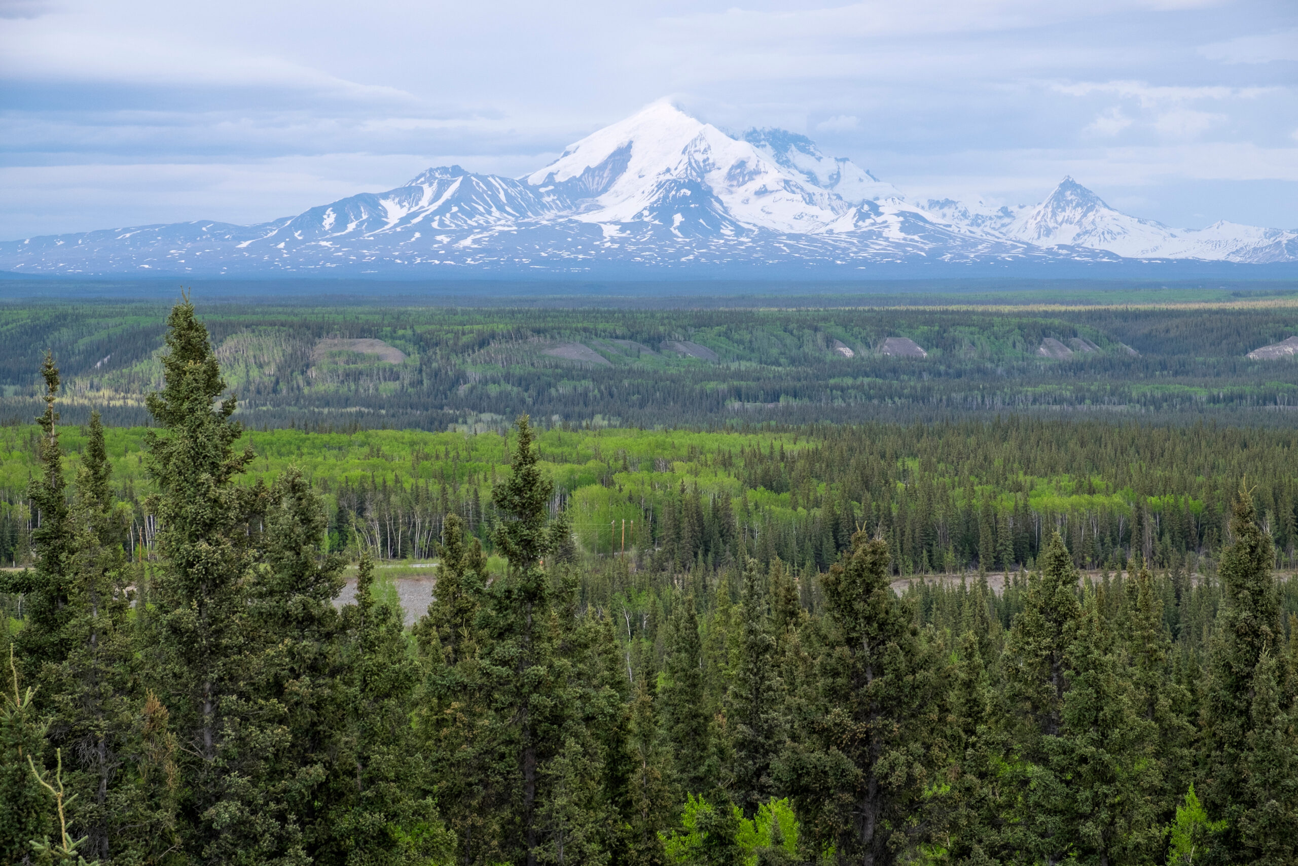
Mt. Blackburn stands at 16,390 ft elevation in the Wrangell Range of southeastern Alaska — making it the tallest peak in the Wrangell Range and the 5th highest peak in the United States. Only Denali (20,310 ft), Mt. Saint Elias (18,008 ft on the US/Canada border), Mt. Foraker (17,400 ft), and Mt. Bona (16,550 ft) exceed Mt. Blackburn’s elevation. The mountain is a glaciated stratovolcano (extinct) within Wrangell-St. Elias National Park — the largest national park in the United States at 13.2 million acres, containing significant portions of the Wrangell, St. Elias, and Chugach mountain ranges.
Mt. Blackburn is widely considered an excellent Denali precursor expedition — similar expedition logistics, glaciated climbing demands, and altitude work but with significantly less traffic (typically 20-40 climbing attempts annually vs Denali’s ~1,200). The Wrangell-St. Elias Backcountry Permit is FREE compared to Denali’s $395 NPS special use fee. The North Ridge from the Nabesna Glacier is the standard climbing route.
Mt. Blackburn is a Class 3-4 glaciated expedition mountaineering objective requiring 10-14 days, bush flight access via Wrangell Mountain Air from McCarthy, expedition-grade gear systems, and full crevasse rescue capability. Generally, the climb organizes around three phases: bush flight access to a glacier base camp on the Nabesna Glacier (north approach, standard) or Kennicott Glacier (south approach, less common); progressive load ferrying through multiple high camps establishing acclimatization toward 14,000 ft; and a summit window watch for the final push to the 16,390 ft summit plateau. Specifically, the North Ridge is the standard climbing route — sustained Class 3-4 glaciated terrain with snow and ice slopes up to 40-50 degrees, complex crevasse navigation, and exposed ridge climbing on the upper sections. Notably, Mt. Blackburn has approximately a 40-60% summit success rate with experienced parties — similar to Denali. The Wrangell-St. Elias Backcountry Permit is FREE (vs Denali’s $395 NPS fee) and the wilderness orientation requirement is less bureaucratic — appealing to expedition climbers seeking Denali-equivalent experience without Denali-level crowds and costs.
Find Hotels, Flights & Trips for the World’s Best Hiking Destinations
The Global Summit Guide Travel Shop on Expedia — curated for outdoor adventurers, mountaineers, and serious hikers. Patagonia to the Alps. Nepal to the Rockies. Curated lodging for every region we cover.
Explore Travel Shop on Expedia →Key Takeaways
- Mt. Blackburn (16,390 ft) is the tallest peak in the Wrangell Range and the 5th highest peak in the United States.
- Class 3-4 glaciated expedition requiring 10-14 days on the mountain via the North Ridge standard route from the Nabesna Glacier.
- Bush flight access required — Wrangell Mountain Air from McCarthy ($600-1,000 RT per climber). No roads or trails to base camp.
- NPS Wrangell-St. Elias Backcountry Permit is FREE — wilderness orientation required at Copper Center, McCarthy, or Slana visitor centers.
- Excellent Denali precursor — similar expedition logistics and demands but with significantly less traffic (~20-40 attempts annually vs Denali’s ~1,200).
- ~40-60% summit success rate with experienced parties — weather windows and acclimatization limitations turn many attempts back.
- Best season: May through early June with consolidated snow, stable weather windows, and moderating temperatures.
- Expedition-grade gear systems rated to -40°F required including double mountaineering boots, expedition tent, full glacier travel kit, and sled hauling capability.
- Wrangell-St. Elias is the largest national park in the US at 13.2 million acres — true wilderness character with significant solitude vs Alaska Range objectives.
About Mt. Blackburn
Mt. Blackburn is the tallest peak in the Wrangell Range of southeastern Alaska — generally defined by its 16,390 ft elevation that places it as the 5th highest peak in the United States and the dominant summit of the Wrangell-St. Elias National Park. Specifically, only Denali (20,310 ft), Mt. Saint Elias (18,008 ft on the US/Canada border), Mt. Foraker (17,400 ft), and Mt. Bona (16,550 ft) exceed Mt. Blackburn’s elevation. The mountain is a deeply-eroded shield volcano (extinct) with multiple summit horns rising from a massive glaciated plateau. The standard climbing route — the North Ridge from the Nabesna Glacier — was first ascended in 1958 by Bruce Gilbert, Dick Wahlstrom, Hans Gmoser, Adolf Bitterlich, and Leon Blumer.
Specifically, Mt. Blackburn’s distinguishing climbing character involves three factors. First, the elevation (16,390 ft) places it firmly in expedition mountaineering territory — comparable to Denali in altitude exposure and weather complexity. Second, the location within Wrangell-St. Elias National Park (the largest national park in the United States at 13.2 million acres) creates significant wilderness isolation — bush flight access is required from McCarthy via Wrangell Mountain Air, and the nearest rescue infrastructure is days away by aircraft. Third, the technical character — Class 3-4 glaciated climbing with sustained snow and ice slopes up to 40-50 degrees, complex crevasse navigation, and exposed ridge sections — matches Denali’s standard West Buttress route in difficulty grade but with arguably more sustained ice work. Notably, Mt. Blackburn receives a small fraction of Denali’s traffic — typically 20-40 climbing attempts per year compared to ~1,200 annually on Denali — which combined with the FREE Wrangell-St. Elias Backcountry Permit (vs Denali’s $395 NPS special use fee) creates a distinctive climbing experience for expedition mountaineers seeking Denali-equivalent demands without Denali-level crowds.
Geographic context: Mt. Blackburn sits in the central Wrangell Mountains of southeastern Alaska, approximately 60 miles southeast of Glennallen and 25 miles west of McCarthy. The mountain is the highest of three major Wrangell volcanoes that include Mt. Sanford (16,237 ft) to the northwest, Mt. Bona (16,550 ft) to the southeast, and Mt. Drum (12,011 ft) to the northwest. The Kennicott Glacier flows south from Mt. Blackburn’s southern slopes toward McCarthy (the historic copper mining town providing climbing logistics access). The Nabesna Glacier flows north from the standard North Ridge climbing route — the bush flight access glacier for most Mt. Blackburn expeditions.
Naming history: Mt. Blackburn is named after Joseph Clay Stiles Blackburn, a US Senator from Kentucky in the late 1800s and early 1900s. The naming followed the historical pattern of major Alaska peaks being named after eastern US politicians during the territory’s early geographic survey period — similar to how Mt. McKinley (now Denali) was originally named after US Senator William McKinley. The native Ahtna name for the peak has not been adopted in formal US Geographic Survey nomenclature, unlike Denali (officially restored to its native name in 2015).
Mt. Blackburn Climbing Routes
Mt. Blackburn has three primary climbing routes, with one clear standard (the North Ridge) and two alternative routes used by experienced parties seeking variation or less-trafficked options. Generally, the North Ridge accounts for approximately 80-90% of annual climbing attempts due to its established route description, manageable bush flight access via the Nabesna Glacier, and Class 3-4 technical character. Specifically, the alternative routes (Northwest Ridge, Northeast Ridge) involve more committing terrain and are generally attempted by experienced expedition parties as second or third Mt. Blackburn objectives.
North Ridge
Class 3-4 glaciated · 10-14 days · ~13,000 ft total gain · 80-90% of attempts
The North Ridge is the standard Mt. Blackburn climbing route and the route taken by approximately 80-90% of annual attempts. Generally, the route involves bush flight access from McCarthy via Wrangell Mountain Air to a glacier base camp on the Nabesna Glacier at approximately 8,000 ft elevation, then progressive load ferrying through multiple high camps to the summit at 16,390 ft. Specifically, the route involves sustained glaciated climbing with snow and ice slopes up to 40-50 degrees, complex crevasse navigation through the lower glacier sections, and exposed ridge climbing on the upper sections approaching the summit plateau.
Standard high camp progression: Base Camp (~8,000 ft on Nabesna Glacier) → Camp 1 (~11,000 ft on the lower ridge) → Camp 2 / High Camp (~13,500-14,000 ft below the summit plateau) → Summit (16,390 ft). The route involves significant load ferrying — typically 2-3 trips between each camp to establish gear and food caches. Sled hauling is used on the lower glacier sections; pack carrying takes over on the steeper upper ridge.
Northwest Ridge
Class 3-4 glaciated · 12-16 days · Sustained ice and mixed terrain
The Northwest Ridge is a less-trafficked alternative route used by experienced expedition parties seeking variation from the standard North Ridge. Generally, the route involves similar bush flight access to the Nabesna Glacier area but follows a different ridge line up the mountain — typically more sustained on ice and mixed terrain than the standard route. Specifically, the Northwest Ridge sees only 1-3 ascents per year and is generally attempted by parties who have already completed the standard North Ridge or have comparable expedition experience.
The Northwest Ridge involves more sustained ice climbing on the lower sections compared to the standard route, with mixed terrain requiring ice screws and intermediate protection on some pitches. Less crevasse navigation than the North Ridge approach but more committing ice climbing terrain. The route is typically attempted in late May through early June when ice conditions are most stable.
Northeast Ridge
Class 4 sustained · 14-18 days · Technical ice and steep snow
The Northeast Ridge is the most-technical Mt. Blackburn route, generally considered the route for expert expedition parties seeking sustained technical climbing. Generally, the route involves Class 4 sustained ice and steep snow climbing with significant exposure and pitched climbing requirements. Specifically, the route sees fewer than 1 ascent per year on average and is rarely attempted relative to the standard North Ridge.
The Northeast Ridge involves sustained Class 4 ice and steep snow climbing with significant exposure throughout. Pitched climbing with intermediate protection (ice screws, snow stakes, pickets) is required on multiple sections. Approach via the Kuskulana Glacier from the east — different bush flight access than the standard North Ridge routes.
Day-by-Day Expedition Itinerary
The standard Mt. Blackburn expedition itinerary spans 10-14 days on the mountain plus 3-5 days of travel and weather buffer days — generally a 3-week total trip window. Specifically, the schedule below represents the typical North Ridge progression with realistic weather contingency built in.
| Day | Activity | Elevation | Notes |
|---|---|---|---|
| Day -2 | Drive Anchorage → McCarthy | ~2,000 ft (McCarthy) | 7-8 hour drive via Glenn Highway + McCarthy Road (60 mi gravel from Chitina). Stay in McCarthy. |
| Day -1 | Gear preparation + final logistics | ~2,000 ft | Wilderness orientation at McCarthy NPS visitor center. Final gear check. Bush flight standby. |
| Day 1 | Bush flight → Base Camp (Nabesna Glacier) | ~8,000 ft | 30-60 min flight from McCarthy. Establish base camp. Sort gear and food caches. |
| Day 2 | Acclimatization rest + load prep | ~8,000 ft | Active rest day. Prep sled loads for first ferry. Hydration and acclimatization. |
| Day 3 | Ferry 1 → Camp 1 cache | ~11,000 ft (cache) | Load ferry to Camp 1 location. Cache supplies. Return to Base Camp. |
| Day 4 | Move to Camp 1 | ~11,000 ft (camp) | Move camp to Camp 1. Establish tent platform. Bury cache against weather/wildlife. |
| Day 5 | Acclimatization day at Camp 1 | ~11,000 ft | Active rest. Climb-high-sleep-low option to ~12,500 ft for acclimatization. |
| Day 6 | Ferry 2 → High Camp cache | ~13,500 ft (cache) | Load ferry to High Camp location. Cache supplies. Descend to Camp 1. |
| Day 7 | Move to High Camp | ~13,500-14,000 ft | Move camp to High Camp. Establish tent platform. Recovery time. |
| Day 8 | Acclimatization at High Camp | ~14,000 ft | Climb-high-sleep-low to ~15,000 ft. Weather window watch begins. |
| Day 9 | Summit attempt window | 16,390 ft (summit) | Summit day: 10-14 hours round-trip from High Camp. Predawn start. |
| Day 9-11 | Weather contingency days | ~14,000 ft | Build 2-3 weather day buffer. Most attempts need 2-3 summit window opportunities. |
| Day 12 | Descent High Camp → Camp 1 | ~11,000 ft | Descend with full loads. Collect caches en route. Rapid descent typical. |
| Day 13 | Descent Camp 1 → Base Camp | ~8,000 ft | Continue descent. Final cache collection. Prep for bush flight pickup. |
| Day 14 | Bush flight → McCarthy | ~2,000 ft | Weather-dependent pickup. Build 1-2 day buffer for grounded flights. |
| Day 15-16 | Bush flight weather buffer | Variable | Bush flights can be grounded 2-4 days. Plan extra time in McCarthy. |
| Day 17-18 | Return drive Anchorage | Sea level | 7-8 hour drive. Connection to outbound flight. |
Itinerary flexibility is essential. The schedule above represents a standard 14-day expedition window. Generally, plan for 18-21 day total trip availability with weather contingency. Specifically, common deviations include: extended weather days at any camp (storms can pin parties for 3-5 days), bush flight delays at trip start or end (2-4 days common), and summit window weather requiring 2-3 attempts before success. Notably, climbers who insist on rigid schedules account for a disproportionate share of summit failures and accident incidents — flexibility and patience are essential expedition virtues.
Gear and Equipment
Mt. Blackburn gear demands match Denali expedition requirements — generally the most-demanding mountaineering gear setup available. Specifically, the 10-14 day expedition duration combined with sub-zero temperatures (-30 to -10°F at altitude in May-June) requires expedition-grade equipment across every category.
🎒 Personal Gear
- Double mountaineering boots (Scarpa Phantom 6000, La Sportiva Olympus Mons, or equivalent)
- Crampons (steel, rigid bail for double boots)
- Ice axe (60-70cm general mountaineering axe)
- Mountaineering helmet
- Climbing harness (alpine, with adjustable leg loops for layering)
- Trekking poles (collapsible, with snow baskets)
- Goggles (storm goggles + clear lens spare)
- Glacier glasses (Cat 4 lens for high-altitude UV)
- Headlamp (300+ lumens) + spare batteries
- Personal climbing harness with prusiks for self-rescue
- Avalanche transceiver (current 3-antenna model)
- Avalanche probe + shovel
🛏 Sleeping System
- Expedition down sleeping bag (-40°F rating, e.g., Western Mountaineering Bison or Feathered Friends Snowbunting)
- Synthetic overbag for moisture protection (-20°F additional)
- Closed-cell foam sleeping pad (full-length)
- Inflatable insulated pad (R-value 5+, e.g., Therm-a-Rest XTherm)
- Vapor barrier liner (for sleeping bag interior in extreme cold)
⛺ Shelter
- Expedition tent (4-season, multi-pole, e.g., Hilleberg Nallo 3 GT, Mountain Hardwear Trango 3)
- Snow stakes (8-10 minimum for tent anchoring)
- Snow fluke or deadman anchors (for snow conditions)
- Snow saw (for cutting wind blocks and snow walls)
- Snow shovel (lightweight aluminum, not just avalanche shovel)
🔥 Cooking
- Liquid fuel stove (MSR XGK EX or WhisperLite International)
- Backup stove (separate fuel system recommended)
- White gas (0.5L per person per day = 5-7L total)
- Pots (2L + 1L pots, nested)
- Wind screen (essential at altitude)
- Insulated mug + thermos
- Lighters (3-4 with spares) + matches
🧗 Glacier Travel Kit
- Dynamic rope (8.5mm half/single, 50-60m)
- 4-5 ice screws (10-22cm, primarily 13cm)
- 4-6 snow pickets (24″ aluminum)
- Snow flukes (2-3 for soft snow anchors)
- Prusik cord (5-6mm, 6m total per person)
- Pulleys (rescue + general use)
- Cordelette (7mm, 7m per person)
- Locking carabiners (4-6 per person)
- Non-locking carabiners (8-10 per person)
- Slings (60cm and 120cm, multiple per person)
👕 Clothing System
- Base layers (synthetic or merino, top + bottom, 2 sets)
- Insulating layers (fleece or synthetic insulated jacket + pants)
- Expedition down jacket (~800 fill, hood, 1,000g+)
- Expedition down pants (-20°F equivalent)
- Hardshell jacket (3-layer, hood)
- Hardshell pants (full-zip, articulated knees)
- Mittens (expedition-grade, e.g., Black Diamond Mercury Mitts)
- Glove system (liner gloves + softshell gloves + insulated overgloves)
- Balaclava + neck gaiter
- Warm hat (wool or synthetic)
- Mountaineering socks (multiple pairs, vapor-barrier inner)
📡 Communication & Safety
- Satellite communicator (Garmin inReach Mini 2 or Mini, two-way messaging)
- Personal locator beacon (PLB – backup to inReach)
- First aid kit (expedition scale, including dental kit, epinephrine)
- Repair kit (tent pole repair, stove repair, gear repair)
- Maps + topographic information (laminated, NPS Wrangell-St. Elias)
- Compass + altimeter
- GPS device with topo maps loaded
🎒 Hauling & Packing
- Expedition pack (90+ liter, e.g., Osprey Aether 90, Cilo Gear 75:90)
- Lightweight expedition sled (Para Tech, Rabbit Snow Sleds, or custom)
- Sled hauling harness (waist + chest harness system)
- Webbing for sled rigging
- Stuff sacks (multiple sizes for organization)
- Trash bags (for body waste — required by NPS Leave No Trace)
🍱 Food Strategy
- 2.5-3 lb dry food per person per day = 25-35 lb total food per climber
- High-fat caloric density (~4,000 cal/day target)
- Freeze-dried dinners (Mountain House, Backpacker’s Pantry expedition meals)
- Breakfast options (instant oats, hot cereals, breakfast wraps)
- Lunch foods (cheese, salami, nut butters, energy bars, chocolate)
- Hot drinks (coffee, tea, hot chocolate, electrolyte powders)
- Comfort foods (1-2 lb per person — psychological importance at altitude)
Gear cost reality: Full Mt. Blackburn expedition gear costs $4,000-7,000 to assemble from scratch. Generally, climbers building toward this expedition acquire gear progressively over previous expeditions (Mt. Rainier, Aconcagua, Mexican volcanoes). Specifically, the highest-cost items are: expedition tent ($600-1,500), double mountaineering boots ($600-1,200), expedition down sleeping bag ($700-1,000), expedition down jacket ($600-1,000), expedition pack ($300-500). Notably, Alaska Mountaineering School in Talkeetna rents specialty expedition gear — climbers can rent items they will use only for this one expedition (tents, sleds, fuel containers) rather than purchasing.
Permits and Logistics
Mt. Blackburn permits and logistics are generally less bureaucratic than Denali but require specific advance preparation. Generally, three logistical pieces require coordination: Wrangell-St. Elias backcountry permit (FREE, wilderness orientation required), bush flight booking (Wrangell Mountain Air, $600-1,000), and McCarthy access logistics (drive from Anchorage or fly to McCarthy via direct service).
Wrangell-St. Elias National Park Backcountry Permit (FREE): Mt. Blackburn requires the standard Wrangell-St. Elias Backcountry Permit. Generally, the permit is FREE and obtained at one of three NPS visitor centers: Copper Center (main park headquarters, on the Richardson Highway), McCarthy (small NPS office in town, most convenient for Mt. Blackburn climbers), or Slana (north entrance to the park, less convenient). Specifically, the permit requires wilderness orientation covering Leave No Trace principles, bear safety, weather contingencies, and self-rescue protocols. Plan 1-2 hours for the orientation. Notably, the permit system is significantly less bureaucratic than Denali NPS climbing registration — no $395 special use fee, no 60-day advance submission requirement, and the orientation can be completed at the start of your trip rather than weeks in advance.
Important: NPS Wrangell-St. Elias has remote orientation options. If you cannot reach Copper Center, McCarthy, or Slana in person before climbing, contact the NPS Wrangell-St. Elias backcountry office at least 30 days before your trip to arrange phone or video orientation. This is particularly relevant for international climbers or those flying directly to McCarthy via Anchorage shuttle services. Generally, in-person orientation is preferred but remote options exist for climbers with logistical constraints.
McCarthy Access Logistics
McCarthy is the gateway town for Mt. Blackburn climbing. Generally, access to McCarthy involves significant overland or air logistics. Specifically:
- Drive from Anchorage: 7-8 hours via the Glenn Highway and McCarthy Road. The Glenn Highway is paved Anchorage to Chitina. The McCarthy Road is 60 miles of unpaved gravel road from Chitina to the Kennicott River — significant washboard, dust, and tire-puncture potential. Use 4WD or AWD with full-size spare tire. Drive time depends heavily on road conditions.
- Drive from Glennallen: 4-5 hours via the Edgerton Highway and McCarthy Road. More common for climbers coming from southern Alaska or Yukon.
- Direct flight to McCarthy: Wrangell Mountain Air operates passenger service from Anchorage to McCarthy directly. More expensive than driving (~$300-500 one-way) but saves 7-8 hours each way. Sometimes weather-grounded.
- McCarthy footbridge: Vehicle access ends at the Kennicott River. Climbers cross a footbridge into McCarthy town. Vehicles park at the riverbank.
Lodging in McCarthy: McCarthy and adjacent Kennicott have multiple lodging options including the historic Kennicott Glacier Lodge (historic hotel in the abandoned copper mining town), Ma Johnson’s Hotel (historic hotel in McCarthy), The Potato (lodging + cafe), and various B&Bs and rental cabins. Plan to spend at least 1 night in McCarthy for gear preparation and wilderness orientation before bush flight.
Bush Flight Access
Mt. Blackburn requires bush flight access — there are no roads or trails to base camp. Generally, Wrangell Mountain Air is the primary and most-established bush flight operator servicing the Wrangell peaks. Specifically, the operator flies Cessna 185 and Cessna 206 aircraft on skis for glacier landings, providing access to the Nabesna Glacier (standard North Ridge approach), Kennicott Glacier (south approach), and other Wrangell-St. Elias destinations.
Wrangell Mountain Air: Based in McCarthy, Alaska. Established 1986 with significant Wrangell peaks expedition experience. Provides glacier landings, gear transport, weather monitoring, and climber pickup coordination. wrangellmountainair.com. Bush flight cost approximately $600-1,000 round-trip per climber depending on group size, gear weight, and landing location.
Bush flight weather dependence: Wrangell Mountain Air can be grounded 2-4 days at a time during storm cycles. Generally, this affects both arriving at base camp and departing the mountain. Specifically, climbers must build a 2-3 day weather buffer on both ends of the trip itinerary, and never plan tight connections from bush flight return to airline departures. Notably, late-trip weather grounding is particularly difficult — climbers may be stuck at base camp waiting for flyable weather while gear and food caches dwindle.
Glacier Landing Location Decision
Bush flight landing location affects route selection and expedition character. Specifically:
- Nabesna Glacier (standard, north approach): Most common bush flight landing for Mt. Blackburn. Approximately 8,000 ft elevation. Access to the standard North Ridge route. The most-established expedition logistics with Wrangell Mountain Air. Climbers typically arrive at this base camp.
- Kennicott Glacier (south approach): Less common landing for Mt. Blackburn but accessible. Approximately 6,500 ft elevation. Provides access to alternative south-side routes (less-established, more exploratory). Used by some experienced expedition parties seeking less-trafficked variations.
- Other glaciers: Less common but possible — Kuskulana Glacier (east approach for Northeast Ridge route), specific landing zones depending on snow conditions and pilot judgment.
Guides and Operators
For climbers seeking guided Mt. Blackburn experiences, several established Alaska guide services cover the standard North Ridge route. Generally, guided Mt. Blackburn climbs are significantly less common than guided Denali climbs but available through expedition-focused operators.
- Alaska Mountaineering School (AMS) — Talkeetna: The premier locally-based Alaska guide service with significant Wrangell peaks expedition experience. Glacier travel courses, Mt. Blackburn expeditions, and Mt. Sanford alternatives. See our AMS guide and climbalaska.org.
- American Alpine Institute (AAI): Bellingham-based with Alaska expedition program including Wrangell peaks. Strong glacier travel course program for Mt. Blackburn preparation.
- Alpine Ascents International: Seattle-based Alaska expedition operator. Wrangell program available with experienced guides.
- Mountain Trip: Specialty Denali guide service that occasionally offers Wrangell peaks expeditions. Higher guide-to-client ratios typical.
- Wrangell-based independent guides: Smaller-scale independent guides operating from McCarthy. Less established than the major Alaska guide services but offer more customized expedition experiences.
Guided vs independent decision: Mt. Blackburn is generally considered appropriate for experienced expedition climbers to attempt independently (with proper team and skills) — unlike Denali, where most climbers benefit from guided service. Generally, the smaller party size (typically 2-4 climbers), less bureaucratic permit process, and less crowded mountain make independent expeditions more feasible. Specifically, independent climbing is appropriate for parties that have completed: Denali (or equivalent expedition), Mt. Sanford or Mt. Bona as Wrangell experience, and formal glacier travel training. Notably, first-time Wrangell climbers should strongly consider guided service or partner with experienced Mt. Blackburn climbers — the FREE permit doesn’t reduce the wilderness self-sufficiency requirements.
Best Seasons for Mt. Blackburn
Mt. Blackburn’s climbing season is narrow — generally April through June with optimal conditions in May and early June. Specifically, the seasonal pattern is shaped by snow stability, weather windows, and bush flight conditions.
Spring · Apr-May
Prime expedition season. Most stable snow conditions and weather windows. Cold (-30 to -10°F at altitude) but stable. Best for serious attempts.
Summer · Jun
Late prime season. May-early June optimal. Moderating temps (-10 to 20°F at altitude). Most-trafficked window.
Fall · Jul-Aug
Season effectively ends. Increasing crevasse opening, rockfall hazards, warmer temperatures making conditions variable.
Winter · Sep-Mar
Off-season for nearly all climbers. Sub-zero temps, limited daylight, grounded bush flights. Expert specialists only.
Why May-Early June is optimal: Late spring provides the ideal balance of snow stability, weather windows, and temperatures. Generally, snow consolidation is excellent (firm climbing surfaces, manageable crevasse navigation), weather patterns are most stable (longer summit windows between storms), daylight is sufficient for long summit days (16+ hours), and temperatures are moderate enough for comfortable expedition life while still cold enough to maintain snow stability. Specifically, peak conditions typically occur mid-May to early June — most experienced parties target this window. Notably, late June onwards sees: increasing crevasse opening (significant additional crevasse hazard), warmer temperatures (snow becomes punchy and variable), and increased rockfall on rocky sections. Avoid attempting Mt. Blackburn after mid-July.
Safety Considerations
Mt. Blackburn safety considerations span standard expedition mountaineering risks plus specific Wrangell wilderness factors. Generally, three concerns deserve specific attention.
1. Crevasse Falls on Lower Glacier
The lower Nabesna Glacier (and Kennicott Glacier on south approaches) has significant crevasse hazard. Generally, this is the same risk profile as Denali’s Kahiltna Glacier — crevasses can be hidden under snow bridges, particularly in early season. Specifically, climbers must travel roped (typically 3-4 climbers per rope) with full crevasse rescue capability including Z-pulley systems, prusik ascension, snow anchor construction, and practiced rope team coordination. Notably, the Wrangell glaciers have less established rescue infrastructure than Denali’s Kahiltna Glacier — NPS ranger presence and SAR response are significantly more limited. Self-rescue capability is essential.
2. Weather Window Variability and Bush Flight Grounding
Mt. Blackburn weather is significantly more variable than Lower 48 expedition mountains. Generally, storm cycles can pin parties at base camp or high camp for 3-5 days. Specifically, climbers must: build 2-3 day weather buffer on both ends of the trip, prepare for extended camp days (bring extra food and stove fuel), and recognize that summit window flexibility may require 2-3 attempts. Notably, bush flight grounding at trip end is particularly difficult — climbers may run out of food while waiting for flyable weather to return to McCarthy. Pack 2-3 days of contingency food beyond planned expedition duration.
3. Altitude Exposure Above 14,000 ft
Mt. Blackburn’s 16,390 ft summit creates significant altitude exposure during the final summit push. Generally, the upper camps (above 14,000 ft) put climbers in genuine altitude territory where acute mountain sickness, high-altitude cerebral edema (HACE), and high-altitude pulmonary edema (HAPE) become real risks. Specifically, climbers must: follow climb-high-sleep-low acclimatization protocols, carry diamox or other altitude medications, recognize early warning signs of altitude illness (headache, nausea, ataxia, persistent cough), and be prepared to descend immediately if symptoms develop. Notably, the Wrangell-St. Elias remoteness amplifies altitude illness risks — rescue infrastructure is days away rather than the hours-scale response on Denali. Don’t push through altitude illness symptoms.
The 8 Common Mistakes on Mt. Blackburn
Avoid These Common Mt. Blackburn Climbing Mistakes
- Treating Mt. Blackburn as an “easier Denali.” While technical difficulty is similar (both Class 3-4 glaciated), Mt. Blackburn arguably has more sustained ice work and less established rescue infrastructure than Denali. The “easier alternative” framing has resulted in climbers underestimating commitment. Build to Mt. Blackburn through similar expedition experience.
- Underestimating bush flight weather dependence. Wrangell Mountain Air can be grounded 2-4 days at a time. Climbers who plan tight connections from bush flight return to airline departures miss flights, lose deposits on guided trips, or push climbing in marginal weather. Build 2-3 day buffer on both ends.
- Not completing Wrangell-St. Elias wilderness orientation. The free permit requires in-person wilderness orientation at Copper Center, McCarthy, or Slana. Climbers who skip this step or attempt to bypass it can be turned away or face significant complications. Plan the orientation as part of trip preparation.
- Skipping a formal glacier travel course. Self-taught glacier travel is statistically the most dangerous form of mountaineering. The $400-700 cost of a course (Alaska Mountaineering School, AAI) is significantly less than the cost of glacier accidents — particularly given the Wrangell’s limited rescue infrastructure.
- Approaching Mt. Blackburn as a first major expedition. Mt. Blackburn is not appropriate as a first expedition mountaineering objective. Build through: Mt. Rainier expedition route or Mexican volcanoes (altitude experience), Aconcagua (sustained altitude), and ideally Mt. Sanford or another Wrangell peak (Wrangell-specific logistics). Don’t make Mt. Blackburn your first 14,000+ ft expedition.
- Insufficient food and fuel for weather contingency days. The 10-14 day standard itinerary assumes weather cooperation. Real-world Mt. Blackburn expeditions frequently require 14-18 days due to storm cycles, summit window failures, and bush flight grounding. Pack 2-3 days of contingency food and fuel beyond planned duration.
- Ignoring altitude acclimatization protocols. The progressive high camp approach (Base Camp → Camp 1 → High Camp) requires climb-high-sleep-low acclimatization days at each camp. Climbers who push too fast through the camps to “save time” account for a disproportionate share of altitude illness incidents. Take the rest days.
- Not packing for sled hauling early in the expedition. The first ferry from Base Camp to Camp 1 requires sled hauling for efficient load transport. Climbers who don’t bring expedition sleds or aren’t experienced with sled hauling find the initial load ferries dramatically harder than expected. Practice sled hauling on Mt. Rainier or similar before Mt. Blackburn.
Mt. Blackburn as a Denali Precursor
Mt. Blackburn is widely considered one of the best Denali precursor climbs available in North America. Generally, the expedition logistics, glaciated climbing demands, altitude work, and weather window dynamics closely match Denali’s standard West Buttress route. Specifically, the parallel structure makes Mt. Blackburn an excellent “dress rehearsal” expedition before attempting Denali.
Mt. Blackburn vs Denali comparison: Both are Class 3-4 glaciated expeditions requiring 10-14 days on the mountain, bush flight access, expedition-grade gear systems rated to -40°F, sled hauling and load ferrying capability, progressive high camp acclimatization, and full glacier travel skills. Key differences: Mt. Blackburn is 5th highest in US (16,390 ft) vs Denali #1 (20,310 ft) — Denali has more sustained altitude. Mt. Blackburn permit is FREE vs Denali $395 NPS fee. Mt. Blackburn sees ~20-40 attempts annually vs Denali’s ~1,200 — significantly more solitude. Mt. Blackburn standard route arguably has more sustained ice work; Denali West Buttress has more sustained altitude.
Why Mt. Blackburn Works as Denali Preparation
Five specific factors make Mt. Blackburn an effective Denali precursor:
- Identical expedition logistics: Bush flight glacier access, multi-day camp progression, sled hauling, weather buffer planning, food and fuel self-sufficiency for 10-14 days.
- Comparable technical character: Class 3-4 glaciated terrain, snow and ice slopes up to 40-50 degrees, crevasse navigation, rope team coordination.
- Similar altitude exposure: Both expeditions reach the 14,000-16,000 ft range with progressive acclimatization. Denali extends higher (17,200 ft High Camp, 20,310 ft summit) but the acclimatization protocol is identical.
- Same gear systems: Mt. Blackburn requires the exact same expedition-grade gear as Denali — same boots, sleeping system, expedition tent, sled, glacier kit. Climbers can use the Mt. Blackburn expedition to validate their full Denali gear setup in real expedition conditions.
- Comparable weather window dynamics: Both mountains require flexible scheduling for storm cycles, summit window watches, and bush flight weather buffer days. The patience and flexibility required is identical.
Recommended Progression: Mt. Blackburn Before Denali
For climbers using Mt. Blackburn as Denali preparation, a typical progression sequence:
- Year 1-2: Mt. Rainier expedition route + glacier travel course + Mexican volcanoes (altitude exposure)
- Year 2-3: Aconcagua (sustained altitude + extended expedition experience)
- Year 3-4: Mt. Sanford or Mt. Bona (Wrangell-specific logistics, easier Wrangell intro)
- Year 4-5: Mt. Blackburn (final Denali precursor expedition)
- Year 5-6: Denali attempt (with full expedition foundation established)
Realistic Denali timeline: Building to Denali through this progression typically requires 5-7 years of structured expedition experience. Climbers who attempt to compress this timeline frequently encounter altitude illness, gear failures, or summit failures that could have been avoided through more gradual progression. See our Denali Progression Plan for detailed year-by-year framework.
Mt. Blackburn FAQ
How high is Mt. Blackburn?
Mt. Blackburn stands at 16,390 ft (4,996 m) elevation. This makes Mt. Blackburn the tallest peak in the Wrangell Range of Alaska and the 5th highest peak in the United States — exceeded only by Denali (20,310 ft), Mt. Saint Elias (18,008 ft on the US/Canada border), Mt. Foraker (17,400 ft), and Mt. Bona (16,550 ft). Mt. Blackburn sits within Wrangell-St. Elias National Park in southeastern Alaska, the largest national park in the United States at 13.2 million acres. The mountain is a glaciated stratovolcano (extinct) with the standard climbing route being the North Ridge from the Nabesna Glacier. Mt. Blackburn is significantly less-trafficked than Denali or the major Alaska Range peaks — typically receiving 20-40 climbing attempts per year compared to approximately 1,200 annually on Denali.
How hard is it to climb Mt. Blackburn?
Mt. Blackburn is a Class 3-4 glaciated expedition requiring expert mountaineering skills, 10-14 days on the mountain, and bush flight access. The standard North Ridge route involves sustained glaciated climbing with crevasse navigation, snow and ice slopes up to 40-50 degrees, and altitude work above 14,000 ft. Technical requirements include: double mountaineering boots, crampons, ice axe with practiced self-arrest, full rope team and crevasse rescue capability (Z-pulley, prusik systems), expedition-grade gear systems rated to -40°F, sled hauling and load ferrying capability, and the physical and psychological endurance for 10-14 days at altitude. Mt. Blackburn is widely considered an excellent Denali precursor — similar expedition logistics and demands but with significantly less traffic. Approximately a 40-60% summit success rate with experienced parties.
Do you need a permit to climb Mt. Blackburn?
Yes — Mt. Blackburn requires a Wrangell-St. Elias National Park Backcountry Permit, but it is FREE. The permit requires wilderness orientation at one of the NPS visitor centers (Copper Center, McCarthy, or Slana) before climbing. The orientation covers Leave No Trace principles, bear safety, weather contingencies, and self-rescue protocols. The system is significantly less bureaucratic than Denali (which requires a $395 NPS special use fee submitted 60+ days ahead) — but Wrangell-St. Elias wilderness self-sufficiency expectations remain the same. The FREE permit + minimal bureaucracy is one of the appeal factors of Wrangell peaks vs Denali — climbers seeking expedition experience without the Denali permit and crowd complexity find Mt. Blackburn an attractive alternative. There is no climbing fee for Mt. Blackburn or any other Wrangell-St. Elias peak.
How do you get to Mt. Blackburn?
Mt. Blackburn requires bush flight access — there are no roads or trails to base camp. Wrangell Mountain Air based in McCarthy, Alaska is the primary bush flight operator. Flights deliver climbers to a glacier base camp on either the Kennicott Glacier (south approach, less common) or the Nabesna Glacier (north approach, standard for the North Ridge route). Bush flight cost is approximately $600-1,000 round-trip per climber. The flight takes 30-60 minutes from McCarthy, depending on landing location. McCarthy itself requires a long drive — approximately 7-8 hours from Anchorage via the Glenn Highway and the unpaved McCarthy Road (60 miles of gravel road from Chitina). Climbers should plan: Anchorage to McCarthy (1 day driving), gear preparation in McCarthy (1 day), bush flight to glacier base camp (1 day weather-dependent), climbing (10-14 days), bush flight out (1 day weather-dependent), return drive (1 day). Total trip window: minimum 3 weeks.
Is Mt. Blackburn a good Denali precursor?
Yes — Mt. Blackburn is widely considered one of the best Denali precursor climbs available in North America. The expedition logistics, glaciated climbing demands, altitude work, and weather window dynamics closely match Denali’s standard West Buttress route. Similarities include: bush flight glacier access, 10-14 day expedition duration with progressive high camps, expedition-grade gear systems rated to -40°F, sled hauling and load ferrying logistics, crevasse rescue requirements, and altitude work above 14,000 ft. Key differences from Denali: Mt. Blackburn is significantly less-trafficked (20-40 attempts annually vs Denali’s ~1,200), uses Wrangell-St. Elias FREE backcountry permits vs Denali’s $395 NPS special use fee, has less bureaucratic permit process, and provides more solitude and wilderness character. The technical difficulty is roughly equivalent to Denali (both Class 3-4 glaciated) but Mt. Blackburn’s standard route arguably has more sustained ice work. Climbers using Mt. Blackburn as a Denali precursor typically use it as their final preparation expedition in the season before their planned Denali attempt.
When is the best time to climb Mt. Blackburn?
Mt. Blackburn’s climbing season is narrow — generally April through June with optimal conditions in May and early June. April provides the most stable snow conditions but cold temperatures (-30 to -10°F at altitude) and limited daylight. May through early June is the prime window with consolidated snow, longer daylight, more stable weather patterns, and temperatures moderating to -10 to 20°F at altitude. Late June through July sees increasing crevasse opening, rockfall hazards, and warmer temperatures making snow conditions more variable. August onward — the Wrangell climbing season effectively ends. Mt. Blackburn’s optimal climbing window is shorter than Denali’s (Denali extends through mid-July) due to the Wrangell Range’s lower latitude and different glacier dynamics. Winter climbing (October-March) is for expert specialists only — sub-zero temperatures, limited daylight, grounded bush flights during storms, and dramatically increased commitment. Most climbers target mid-May to early June for optimal conditions and weather windows.
Sources and Methodology
Numbered Source References
This Mt. Blackburn climbing guide synthesizes data from federal land management agencies, established Alaska guide services, bush flight operators, and expedition mountaineering literature.
- National Park Service Wrangell-St. Elias. nps.gov/wrst — official source for Wrangell-St. Elias backcountry permits, wilderness orientation requirements, park access, and visitor center locations.
- Wrangell Mountain Air. wrangellmountainair.com — primary bush flight operator for Wrangell peaks expeditions, established 1986 with significant Mt. Blackburn expedition experience.
- Alaska Mountaineering School (AMS). climbalaska.org — Talkeetna-based premier Alaska guide service with Wrangell peaks expedition heritage and glacier travel course curriculum.
- American Alpine Journal. Historical expedition reports including the 1958 first ascent and subsequent climbing history of Mt. Blackburn.
- USGS Geographic Survey. Mt. Blackburn elevation data (16,390 ft), location coordinates, and topographic mapping.
- American Alpine Club. Wrangell peaks climbing statistics, accident reports, and historical expedition records.
- Internal Global Summit Guide research. Cross-referenced with our Best Mountains in Alaska state hub, Denali Climbing Guide, Denali Progression Plan, Mt. Blackburn Routes detailed page, Mt. Sanford guide, and Mt. Bona guide.
- NPS Wrangell-St. Elias Climber Reports. Annual climbing season summaries including Mt. Blackburn attempt counts, success rates, and incident reports.
Methodology note. Quarterly review cycle — next review September 2026 (post-summer expedition season). Wrangell Mountain Air bush flight pricing, NPS Wrangell-St. Elias backcountry permit procedures, and guide service availability may evolve; verify current information directly with the relevant operators within 4-8 weeks of your planned expedition.
What’s Next?
Mt. Blackburn: The Wrangell’s Tallest, North America’s Premier Denali Precursor
Generally, Mt. Blackburn is the tallest peak in the Wrangell Range and the 5th highest peak in the United States — a Class 3-4 glaciated expedition matching Denali in technical commitment but with significantly less traffic, FREE Wrangell-St. Elias backcountry permits, and less bureaucratic access. Specifically, the standard North Ridge route requires 10-14 days, bush flight access via Wrangell Mountain Air from McCarthy, expedition-grade gear systems, and full glacier travel capability. Notably, Mt. Blackburn is widely considered the premier Denali precursor expedition in North America — developing the exact skill set needed for Denali while providing wilderness solitude not available on the West Buttress.
See Climbing Routes Denali Complete Guide →Was this helpful?
🏔Related peaks nearby
🧭Explore & compare
Global Summit Guide is an independent mountaineering resource founded in 2026. The team combines first-hand trekking and climbing experience with in-depth research and professional health and nutrition review to help climbers choose objectives, prepare properly, and stay safe.
Health, altitude, and nutrition content is reviewed by Taylor Ludlow (Registered Nurse) and Brigg Hoopes (Nutritionist).
What We Don't Know Yet
Mountain information changes quickly. This box explains the limits of what this page can responsibly promise.
- Permit availability, reservation windows, quotas, and official fee rules may change after this page is updated.
- Guide-company prices, departure dates, guide ratios, included services, and cancellation rules can change without notice.
- Weather, snowpack, avalanche risk, road access, and route conditions can change quickly and may be different on your climbing dates.
- Route conditions, trailhead access, crevasse exposure, stream crossings, and rescue access may vary from published planning guidance.
- Total trip cost can change with flights, lodging, guide pricing, permits, gear rentals, transportation, and exchange rates.
Verify current conditions with official land managers, guide services, local forecasts, and current route reports before booking or climbing.
Part of this Global Summit Guide cluster
Explore the complete Mountains guide for more context, routes, planning links, and related resources.
Mountaineering, rock and ice climbing, glacier travel, and high-altitude activity are inherently dangerous and can result in serious injury or death. The information on Global Summit Guide is provided for general informational and educational purposes only and is not a substitute for professional instruction, qualified guiding, proper equipment, or your own judgment and experience.
Route conditions, weather, snowpack, permits, regulations, and hazards change constantly and may differ from what is described here. Details may be incomplete, out of date, or contain errors. Always verify current information with local authorities, certified guides, and official sources before making any decision in the mountains.
Nothing on this site is medical, legal, or financial advice. Our fitness, acclimatization, altitude, and nutrition content is general in nature; consult a qualified physician before beginning any strenuous exercise program or exposing yourself to high altitude.
You are solely responsible for your own safety and decisions. To the fullest extent permitted by law, Global Summit Guide and its team accept no liability for any loss, injury, damage, or expense arising from use of, or reliance on, this information. By using this site you acknowledge these risks and accept these terms.
Some links on this site may be affiliate links. If you buy through them we may earn a small commission at no extra cost to you; this never affects our recommendations.
Global Summit Guide recommendation path
Next Best Mountain to Research
Use these recommendations to continue the right planning path instead of stopping on one page.
Use current permit, weather, route, and operator information before booking or climbing.