
Last updated May 25, 2026
Climbing Capitol Peak 2026: Colorado’s Hardest 14er, the Knife Edge Route & the Elk Mountains’ Most Dangerous Summit
At 14,137 feet, Capitol Peak is widely regarded as Colorado’s hardest and most dangerous fourteener. The infamous Knife Edge — 100 feet of narrow ridge with 1,000-foot drops on either side — combined with sustained Class 4 climbing, loose rock, and complex route-finding makes this peak the highest-fatality-ratio mountain in the United States. The complete 2026 climbing guide built on the lessons of climbers who came before.
Capitol Peak occupies a sobering position in Colorado mountaineering. The peak isn’t the highest in Colorado — Mount Elbert claims that title at 14,440 feet, 303 feet taller. It isn’t the highest in the Elk Mountains — Castle Peak takes that distinction at 14,279 ft. What Capitol Peak holds, definitively, is reputation as the most dangerous fourteener in Colorado and one of the most dangerous mountains in the United States. Data tells the story directly: from 1947 to 2018, 91% of climbing accidents on Capitol Peak resulted in fatalities — the highest fatality-to-accident ratio of any major US mountain. In 2017 alone, five climbers died within a six-week span. Capitol Peak demands a level of respect that few other 14ers require.
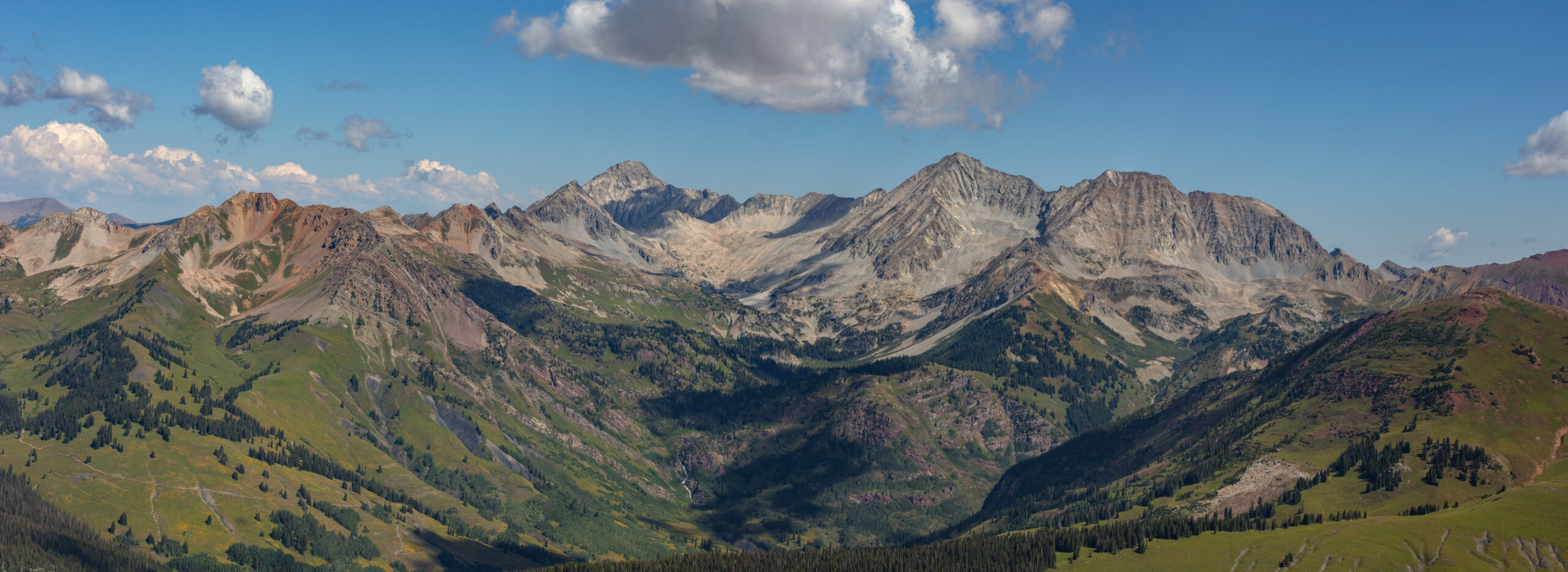
The mountain stands in the Elk Mountains of central Colorado, within the Maroon Bells-Snowmass Wilderness Area of White River National Forest. The peak sits approximately 14 miles west of Aspen and 9 miles north of Snowmass Village. The mountain is notable for its impressive vertical relief — rising 7,500 feet (2,300 m) above the Roaring Fork Valley and nearly 6,000 feet (1,800 m) above Snowmass Village in just under 9 horizontal miles. The Elk Mountains as a range are known for being among Colorado’s most dramatic and dangerous — Pyramid Peak and the Maroon Bells (North Maroon and Maroon Peak) join Capitol on most lists of Colorado’s most dangerous fourteeners due to combinations of loose rock, complex route-finding, and sustained technical climbing.
The climbing itself sets Capitol Peak apart from other Colorado 14ers. The standard Northeast Ridge route is 17 miles round trip with 6,000 feet of elevation gain — making it one of the longest standard 14er routes in the state. The route demands sustained Class 4 climbing on loose rock throughout the upper mountain. The famous Knife Edge — 100 feet of narrow ridge between the K2 sub-peak and the East Ridge — features 1,000-foot drops on both sides and requires extreme caution. Most parties find the section after the Knife Edge harder than the Knife Edge itself — sustained Class 4 climbing on the East Ridge with significant exposure and loose rock through to the summit. All routes to the summit are at least Class 4.
Find Hotels, Flights & Trips for the World’s Best Hiking Destinations
The Global Summit Guide Travel Shop on Expedia — curated for outdoor adventurers, mountaineers, and serious hikers. Patagonia to the Alps. Nepal to the Rockies. Curated lodging for every region we cover.
Explore Travel Shop on Expedia →This guide covers what you need to attempt Capitol Peak in 2026. The Northeast Ridge standard route in detail, including the Knife Edge and the K2 sub-peak. The fatal patterns documented in American Alpine Club accident reports — particularly the off-route shortcuts that have claimed multiple lives. Capitol Lake camping logistics and wilderness permits. Gear, season analysis, and operator pricing. And honest assessment of who should attempt this peak — because Capitol Peak isn’t just challenging, it’s a mountain where mistakes have repeatedly proven fatal. The 2017 tragedies and subsequent accidents underscore that this peak demands genuinely elite Colorado mountaineering competence.
Capitol Peak At a Glance
The essential reference facts for Capitol Peak. Detailed sections follow below.
| Summit elevation | 14,137 ft (4,309 m) |
|---|---|
| Location | Elk Mountains, central Colorado, USA |
| Coordinates | 39.1503°N, 107.0833°W |
| Colorado rank | 29th highest peak in Colorado |
| Mountain range | Elk Mountains, Sawatch Range region |
| Wilderness area | Maroon Bells-Snowmass Wilderness |
| National forest | White River National Forest |
| Vertical relief | 7,500 ft above Roaring Fork Valley; 6,000 ft above Snowmass Village in 9 horizontal miles |
| Dangerous reputation | 91% fatality-to-accident ratio (1947-2018) — highest of any major US mountain |
| Notable tragedy | 2017 season: five fatalities within six weeks |
| Standard route | Northeast Ridge via Knife Edge (Class 4) |
| Sub-peak | K2 (13,664 ft) — crossed before the Knife Edge |
| Iconic crux | The Knife Edge — 100 ft of narrow ridge with 1,000 ft drops on both sides |
| Trailhead | Capitol Creek Trailhead (9,300 ft) |
| High camp | Capitol Lake (~11,600 ft) |
| Trail distance | ~17 miles round trip from trailhead |
| Total elevation gain | ~6,000 ft |
| Typical trip duration | 2-3 days with overnight camping at Capitol Lake |
| Best season | Mid-July to mid-September (peak window late July-August) |
| Permits | Overnight camping permit required in designated zones (free); helmets advised |
| 2026 guided cost | $1,500-$3,000 for 3-day guided programs |
| Gateway towns | Aspen (14 miles east); Carbondale; Snowmass Village (9 miles south) |
| Bear canisters | Required for camping at Capitol Lake (USFS regulation) |
Capitol Peak is the most dangerous fourteener in the United States. The mountain’s fatality-to-accident ratio of 91% (from 1947 to 2018) is the highest of any major US mountain. This ratio reflects a brutal reality: when accidents happen on Capitol Peak, they tend to be fatal. The Knife Edge isn’t the most dangerous section — most fatalities have occurred on the loose Class 4 terrain between K2 and the summit, on off-route shortcuts attempted by climbers trying to avoid the Knife Edge, or during descent when fatigue compounds existing hazards. Mountain Rescue Aspen has clear messaging: “There is NO shortcut. Stay on the standard route to and from the summit.” Climbers attempting Capitol Peak should approach with genuine humility about the route’s serious nature.
Why Capitol Peak Earns Its Dangerous Reputation
Capitol Peak holds a precise position in Colorado mountaineering culture. The mountain combines four distinguishing elements: sustained Class 4 climbing throughout the upper mountain (not just a brief crux); loose rock on the East Ridge that has caused multiple fatal accidents; complex route-finding with several documented fatal off-route patterns; and the famous Knife Edge as a final psychological challenge. The combination produces a peak where mistakes have repeatedly proven fatal — and the 2017 season’s five fatalities in six weeks made the patterns starkly clear.
The Knife Edge Section
The Knife Edge — 100 feet of narrow ridge between the K2 sub-peak and the East Ridge — is the most photographed feature of Capitol Peak and the section most climbers fear. The ridge narrows to a knife-edge width with 1,000-foot drops on both sides. Most climbers traverse the section by sitting and scooting along the ridge using both hands and legs for stability — what’s commonly called the “butt-scoot” technique. Some experienced climbers walk the ridge upright, particularly when conditions are dry. Despite its dramatic appearance, the Knife Edge itself is rarely the actual location of fatal accidents — the section is short and most climbers handle it carefully. However, the Knife Edge represents the psychological gateway to the upper mountain. Climbers who can’t manage the Knife Edge shouldn’t continue beyond it.
The Loose Rock Class 4 East Ridge
The East Ridge from the Knife Edge to the summit features sustained Class 4 climbing on rock that’s notoriously loose. Many climbers consider this section harder than the Knife Edge itself. Holds can break unexpectedly. Route-finding through the broken terrain demands attention. Falls from this section have caused multiple fatalities — including a 2017 fatality involving a 200-foot fall from the east side of the ridge between K2 and the Knife Edge. The section requires sustained Class 4 climbing with significant exposure on rock that demands skepticism about every hold. Climbers used to solid rock on other Class 4 14ers find Capitol’s looseness genuinely unsettling.
The Off-Route Shortcut Pattern
Multiple fatalities on Capitol Peak have followed a documented pattern: climbers reach the summit, then attempt shortcuts on descent rather than reversing the standard route. The standard route requires re-crossing the Knife Edge and descending K2 — a tiring proposition after summit fatigue. Several climbers have attempted direct descents down north-facing gullies that “look like shortcuts” from the summit. These descents cliff out — climbers find themselves unable to descend safely or return to the standard route. The 2017 fatality of Zackaria White followed exactly this pattern: White attempted a direct gully descent against his experienced partner’s advice and fell 600 feet. Mountain Rescue Aspen’s repeated message is unambiguous: “There is NO shortcut.”
The K2 Sub-Peak Confusion
The K2 sub-peak at 13,664 feet creates additional route-finding complexity. The standard route traverses around K2 rather than going over it. Some climbers reach K2 and continue on the obvious ridge that connects K2 with Capitol — which is NOT the standard route. The 2017 fatality of Jake Lord occurred on this off-route ridge when he fell 160 feet from a loose boulder. The ridge is often taken in error by climbers unfamiliar with the route. Proper route-finding requires bypassing K2 to the south rather than crossing its summit. Pre-trip route study using 14ers.com photos and topographic maps is essential — climbers shouldn’t attempt route-finding on-the-fly given the consequences of error.
The 2017 Capitol Peak season: five fatalities in six weeks. Capitol Peak experienced an unprecedented five fatalities within a six-week span during summer 2017. On July 15, Jake Lord (25) fell from an off-route ridge near K2. On August 6, Jeremy Shull (35) fell 200 feet between K2 and the Knife Edge. On August 21, Carlin Brightwell and Ryan Marcil died in a fall from the upper mountain. On August 26, Zackaria White (21) fell 600 feet attempting a shortcut down a north gully against his experienced partner’s advice. The pattern across these accidents reveals consistent themes — climbers off the standard route, inexperience relative to the route’s demands, fatigue-driven decisions on descent. The American Alpine Club’s accident report titled “Off-route, Inexperience” captures the lessons. Modern Capitol Peak climbing now operates with greater route-awareness, but the underlying hazards remain.
Who Should Climb Capitol Peak?
Capitol Peak sits at the highest end of standard route 14er difficulty in Colorado. The peak is appropriate only for experienced climbers who have completed multiple Class 3 and Class 4 fourteeners and can demonstrate genuine competence with sustained exposure on loose rock. Honest pre-trip self-assessment matters more on Capitol than on any other 14er.
Capitol Peak Is Appropriate For:
Climbers with multiple Class 4 14er ascents. Climbers who’ve successfully completed Crestone Needle, Little Bear Peak, North Maroon Peak, and similar Class 4 fourteeners have the technical foundation. Capitol Peak demands more sustained Class 4 than any of these — it’s the natural last step in Colorado 14er progression.
Climbers comfortable with loose rock at altitude. The East Ridge demands route selection on rock where holds can fail unexpectedly. Climbers who’ve experienced loose rock on the Maroon Bells or Pyramid Peak have the relevant experience.
Climbers who can stay calm in dangerous situations. The exposure on the upper mountain is genuinely real and a fall would likely be fatal. The climber must remain calm and focused even when the route demands sustained attention. Climbers prone to panic in exposed situations shouldn’t attempt this peak.
Backpacking-capable climbers. The 17-mile round trip with 6,000 feet of elevation gain demands serious physical fitness combined with backpacking competence for the Capitol Lake overnight. The route length and elevation profile leaves little margin for slow movement.
Climbers with strong route-finding skills. The complex route demands genuine map-reading and pre-trip study. Climbers who navigate confidently and study photos before climbing have the foundation. Climbers who’d rather “figure it out” on the mountain face elevated risk.
Pre-dawn start commitment. The pre-dawn departure from Capitol Lake (typical 02:00-04:00) isn’t optional. Climbers must commit to the early start to manage afternoon thunderstorms during summer monsoon season.
Capitol Peak Is Not Appropriate For:
Climbers without Class 4 experience. The sustained Class 4 climbing demands real competence. Climbers without prior Class 4 fourteener experience should build skills on easier peaks first. The route’s mortality rate tells the cost of inadequate preparation.
Beginning 14er climbers. Capitol Peak isn’t a first 14er, second 14er, fifth 14er, or even tenth 14er for most climbers. Complete progression through Class 1-3 and easier Class 4 peaks first.
Climbers planning to split up. Multiple Capitol Peak accidents have followed climbing partners separating on descent. Stay together throughout the route — particularly during descent when fatigue creates decision-making vulnerability.
Climbers tempted by shortcuts. Multiple fatalities have followed shortcut decisions. The standard route exists because alternative descents cliff out. Climbers tempted to find their own way down face genuinely elevated risk.
Climbers on rigid schedules. Weather windows and route conditions demand flexibility. Climbers locked into specific summit dates face pressure to climb in marginal conditions. Build buffer days into the schedule.
Solo climbers. The complex route, serious objective hazards, and remote setting make solo attempts genuinely dangerous. Even experienced climbers should plan in teams of 3-4 partners with strong group dynamics.
Where Capitol Peak Fits in Your Colorado 14er Progression
| Stage | Peak / Experience | Difficulty | What it builds |
|---|---|---|---|
| Foundation | Mount Bierstadt, Mount Sherman, Mount Elbert | Class 1 walk-ups | Altitude exposure, basic 14er fitness |
| Class 2 scrambles | Quandary Peak, Mount Massive, Grays Peak | Class 2 | Off-trail navigation, talus hopping |
| First Class 3 challenges | Mount Sneffels, Wetterhorn, Longs Peak Keyhole | Class 3 | Brief technical sections; exposed terrain |
| Sustained Class 3 | Crestone Peak via Red Gully | Class 3 sustained | Longer Class 3 climbing; loss-and-regain profile |
| First Class 4 fourteeners | Crestone Needle, North Maroon Peak | Class 4 | Genuine technical exposure; loose-rock experience |
| Loose-rock Class 4 | Maroon Peak, Pyramid Peak | Class 4 loose | Loose rock route-finding; sustained exposure |
| Snow-route Class 4 | Little Bear Peak via Hourglass | Class 4 with snow | Snow climbing competence with technical rock |
| The Capitol Peak step | Capitol Peak via Knife Edge | Class 4 sustained | Longest route; loose East Ridge; Knife Edge; off-route hazards |
| Beyond 14ers | Alaska Range; Canadian Rockies | Class 5+ | Where Capitol’s lessons apply outside Colorado |
The Standard Routes Up Capitol Peak
Three routes exist on Capitol Peak, though only the Northeast Ridge sees significant traffic. All routes are at least Class 4. The Northeast Ridge handles approximately 95% of climbers. The Northwest Buttress provides a rare technical alternative. The North Face routes are reserved for elite alpine climbing parties.
| Route | Side | Difficulty | Round trip | Usage |
|---|---|---|---|---|
| Northeast Ridge via Knife Edge (Standard) | Northeast | Class 4 sustained | ~17 mi | ~95% of climbers |
| Northwest Buttress | Northwest | Class 5.4 | ~14 mi | ~3% of climbers |
| North Face Routes (multiple) | North | Class 5+ technical | ~14 mi | ~2% of climbers |
Route 1: Northeast Ridge via Knife Edge (Standard — 95% of climbers)
The Northeast Ridge is the standard climbing line on Capitol Peak and the only non-technical route to the summit. The route starts at Capitol Creek Trailhead (9,300 ft), follows the Capitol Lake Trail 6-7 miles to Capitol Lake (11,600 ft) where most parties establish high camp, climbs to Daly Saddle (13,300 ft) on summit day morning, traverses around K2 sub-peak (13,664 ft), crosses the famous Knife Edge, then ascends the loose Class 4 East Ridge to the summit at 14,137 ft. Most parties complete the climb as a 2-3 day trip with overnight camping at Capitol Lake.
The Full Route Progression
- Capitol Creek Trailhead (9,300 ft): Standard starting point off Capitol Creek Road. Free parking. Limited capacity during peak season. Bear canisters required for any overnight camping in the wilderness.
- Approach to Capitol Lake (9,300-11,600 ft): 6-7 mile hike via the Capitol Creek Trail. Approximately 4-5 hours with backpacking gear. The trail climbs through forest, eventually emerging into alpine meadows below Capitol Peak’s dramatic north face.
- Capitol Lake high camp (11,600 ft): Standard high camp location. Designated camping zones with reservation required (free through White River NF system). Stunning views of Capitol Peak’s north face. Most parties set up Friday afternoon for Saturday summit attempt.
- Pre-dawn departure (11,600 ft): Most parties leave Capitol Lake camp between 02:00 and 04:00. The early start is essential for managing summer monsoon afternoon thunderstorm timing. Headlamps essential. Cool temperatures even in summer.
- Climb to Daly Saddle (11,600-13,300 ft): Approximately 3-4 hours of climbing on the marked trail east from Capitol Lake. The route gains 1,700 feet to the Daly-Capitol Saddle. Forest Service has marked the saddle route with cairns. Stay on the trail throughout this section.
- Traverse around K2 (13,300-13,500 ft): From Daly Saddle, the route traverses around K2 sub-peak (13,664 ft) rather than over it. This is critical route-finding. The standard route bypasses K2 to the south. Climbers who continue over K2’s summit and follow the obvious ridge are OFF-ROUTE — this ridge has claimed multiple lives.
- Approach to Knife Edge (~13,500 ft): The route brings climbers to the Knife Edge — a 100-foot section of narrow ridge with 1,000-foot drops on both sides. Most climbers use the “butt-scoot” technique — sitting and scooting along the ridge using hands and legs. The section is exposed but short.
- The East Ridge to summit (13,500-14,137 ft): After the Knife Edge, the route climbs the loose East Ridge. This sustained Class 4 climbing on notoriously loose rock is considered by many to be harder than the Knife Edge. Sustained focus required. Multiple fatalities have occurred on this section.
- Summit at 14,137 ft: Capitol Peak’s summit. Stunning views of the Elk Mountains and across to the Maroon Bells. Most parties stay 20-30 minutes for photos and absorption before beginning the descent.
- Descent: Reverse the route — DO NOT attempt shortcuts. Multiple fatalities have followed climbers attempting north-facing gully descents. The standard route is the only safe descent. Most parties take 5-7 hours to descend from summit to Capitol Lake camp. Total summit day from camp: 10-14 hours.
Strengths
- Iconic Knife Edge crossing experience
- One of Colorado’s most dramatic 14er settings
- Capitol Lake camp is spectacular
- The “ultimate” Colorado Class 4 14er challenge
- Strong sense of achievement on summit
- Less crowded than other Elk Mountains 14ers
Considerations
- Most dangerous standard 14er route in Colorado
- 17-mile round trip is exceptionally long
- Sustained Class 4 climbing demanding
- Loose rock on East Ridge genuinely hazardous
- Off-route fatalities documented repeatedly
- Afternoon thunderstorm timing critical
Route 2: Northwest Buttress (Technical Alternative)
The Northwest Buttress is a rare technical alternative to the standard Northeast Ridge. The route involves Class 5.4 climbing on the buttress — requiring rope, protection, and rock climbing competence beyond standard 14er scrambling. Approach is from the same Capitol Creek Trailhead with overnight at Capitol Lake. Most parties climbing this route are experienced rock climbers seeking technical variety. The route avoids the Knife Edge but adds genuine rock climbing demands. Commercial guiding doesn’t typically operate on this route. The Northwest Buttress provides a more aesthetic technical experience but at the cost of significantly higher technical demands.
Route 3: North Face Routes (Elite Alpine)
The dramatic North Face of Capitol Peak presents some of the most demanding technical climbing in Colorado’s 14ers. Multiple route variations exist at Class 5 and harder grades, including ice routes during winter conditions. The face presents sustained vertical relief and serious objective hazards. Climbers attempting North Face routes are typically experienced Colorado alpinists seeking the most demanding objectives in the state. Commercial guiding doesn’t operate on these routes. Few documented modern ascents exist — the face attracts elite parties but defeats most attempts. The North Face represents Capitol Peak at its most technically demanding, well beyond standard 14er objectives.
Capitol Peak Climbing History: From 1860 to 2026
The Elk Mountains region was home to Ute peoples for centuries before European contact. The Northern Ute and various other indigenous groups maintained extensive territorial and spiritual connections to the Roaring Fork Valley and surrounding mountains. The peak now called Capitol Peak held significance in indigenous traditions long before European-American climbing activity. Modern recognition of this heritage is increasingly part of cultural acknowledgment surrounding the Elk Mountains.
The Hayden Geological Survey of the 1870s conducted the first systematic American survey of the Elk Mountains. The peak now called Capitol Peak was named for its resemblance to the dome of the U.S. Capitol building when viewed from certain angles. The naming reflects 19th-century American conventions of applying patriotic names to dramatic Western peaks. The peak’s height was first measured during this survey era, establishing its place in early Colorado geographic knowledge.
The first recorded ascent of Capitol Peak occurred in 1909 by Percy Hagerman and Harold Clark. The achievement was significant because Capitol Peak was widely considered impossible to climb due to its dramatic profile and the Knife Edge feature visible from below. Hagerman and Clark’s ascent established the basic line that became the modern Northeast Ridge standard route. The peak was among the last Colorado fourteeners to be climbed — joining the Crestones and a few other peaks as 14ers that defied early climbing attempts until the 20th century.
Through the early 20th century, Capitol Peak saw very few ascents. The peak’s technical demands and the Knife Edge’s intimidating profile deterred most early climbers. Colorado Mountain Club members and small parties of experienced climbers made occasional ascents during this period. The peak’s reputation as one of Colorado’s hardest and most dangerous fourteeners began establishing itself even as climbing remained rare.
The mid-20th century brought systematic interest in completing all of Colorado’s 14ers. Carl Blaurock, Bill Ervin, and other early “all 14ers” climbers had to complete Capitol Peak as part of their pursuit. The peak became established as one of the most technically demanding objectives on the list. Many climbers saved Capitol for late in their 14er pursuit specifically because of its difficulty. The American Alpine Club began documenting accidents and fatalities on the peak during this period.
1947 marks the formal beginning of fatality documentation on Capitol Peak. From 1947 to 2018, the peak would record 91% fatality-to-accident ratio — the highest of any major US mountain. The statistics reveal a brutal pattern: when accidents happen on Capitol Peak, they tend to be fatal. The peak’s combination of sustained exposure, loose rock, complex route-finding, and remote setting prevents the kind of survivable falls that occur on less demanding mountains.
Congress designated the Maroon Bells-Snowmass Wilderness in 1964, protecting the area including Capitol Peak. The 1980 expansion of the wilderness further protected the surrounding terrain. The wilderness designation prohibited mechanical access while preserving the wild character of the region. Capitol Peak became firmly established as a wilderness climbing objective requiring backpacking access and overnight camping at Capitol Lake.
The 2000s saw rapid growth in Colorado 14er climbing as a recreational pursuit. Lists, guidebooks, and online resources (14ers.com launched in 2001) drove tens of thousands of climbers to attempt all 54-58 Colorado peaks above 14,000 feet. Capitol Peak’s annual ascent numbers grew dramatically during this period. The increased climbing traffic brought increased accident numbers, though the peak’s character — and the lethality of accidents when they occurred — remained unchanged. Mountain Rescue Aspen became increasingly active on the peak.
The 2017 Capitol Peak season recorded five fatalities within a six-week span — an unprecedented concentration of deaths on a single Colorado peak. On July 15, Jake Lord fell on an off-route ridge near K2. On August 6, Jeremy Shull fell 200 feet between K2 and the Knife Edge. On August 21, Carlin Brightwell and Ryan Marcil died in falls from the upper mountain. On August 26, Zackaria White fell 600 feet on a shortcut descent. The cluster of deaths drew national attention to Capitol Peak’s dangerous reputation. American Alpine Club published a detailed analysis titled “Off-route, Inexperience” identifying common patterns across the accidents. The 2017 season fundamentally shaped modern Capitol Peak climbing culture, with increased emphasis on route awareness and “no shortcut” messaging from Mountain Rescue Aspen.
The 2018-2021 climbing seasons saw continued strong demand for Capitol Peak despite the 2017 tragedies. Mountain Rescue Aspen and the climbing community emphasized “no shortcut” messaging across multiple channels. 14ers.com and other resources improved route documentation. Annual fatality numbers dropped but didn’t reach zero — additional deaths occurred during these years. The peak’s reputation as Colorado’s most dangerous 14er became firmly established in climbing culture, leading to more careful approach by experienced climbers.
September 2022 saw multiple accidents on Capitol Peak within a single week. A woman climbing solo fell approximately 900 feet after pulling on loose rock near the summit, shortly after crossing the Knife Edge. Mountain Rescue Aspen responded to four separate calls in the Capitol valley within nearly as many days. The events reinforced the peak’s continued hazardous reputation despite increased awareness of its dangers. Climbers continued attempting the peak despite the documented risks — and continued occasionally dying.
The 2023-2025 climbing seasons saw continued strong demand for Capitol Peak with ongoing accident occurrences. Mountain Rescue Aspen continued active operations on the peak. 2026 climbing season is currently active with the standard mid-July through mid-September window. The peak’s reputation as Colorado’s most dangerous 14er remains intact. Climbers approaching the peak in 2026 benefit from extensive online route documentation, AAC accident analysis, and clearer safety messaging — but the underlying route hazards remain unchanged. Capitol Peak demands the same level of respect and competence today as it has across its climbing history.
Safety Lessons from Capitol Peak Accident History
Capitol Peak’s documented accident history provides specific lessons that can save climbers’ lives. American Alpine Club accident reports, Mountain Rescue Aspen incident notes, and 14ers.com community documentation reveal consistent patterns across fatal accidents. Understanding these patterns is essential pre-trip preparation.
The Five Documented Fatal Patterns
| Pattern | What Happens | How to Avoid |
|---|---|---|
| Off-route ridge from K2 | Climbers continue over K2 onto the obvious connecting ridge to Capitol rather than bypassing K2 to the south as the standard route requires. Multiple fatalities including 2017 Jake Lord. | Study route photos before climbing. Standard route bypasses K2 to the south. The obvious ridge is OFF-ROUTE. |
| Shortcut descent attempts | Climbers attempt to descend directly from summit via north-facing gullies that “look like shortcuts.” All cliff out. 2017 Zackaria White fell 600 feet attempting this descent. | “There is NO shortcut.” Mountain Rescue Aspen’s clear messaging. Reverse the standard route exactly, no exceptions. |
| East Ridge loose rock falls | Holds break unexpectedly on the loose Class 4 East Ridge. Climbers fall significant distances on the technical terrain. Multiple documented fatalities. | Test every hold. Move efficiently but not quickly. Expect rock to break. Maintain three points of contact wherever possible. |
| Splitting up | Climbing partners separate during the climb. If one climber gets in trouble, the other doesn’t know. Help can’t be summoned quickly in this terrain. | Stay together throughout the climb, especially on descent. Never separate from your climbing partner. |
| Late timing / weather | Climbers run into afternoon thunderstorms during summer monsoon. Lightning strikes on exposed ridge terrain. Forced rapid descents on dangerous terrain. | Pre-dawn 02:00-04:00 starts essential during monsoon. Plan to be off the Knife Edge by 10:00. Turn back if behind schedule. |
The off-route shortcut pattern explained in detail. Several Capitol Peak fatalities have followed climbers attempting to descend via a north-facing gully visible from the summit area. The gully looks like a faster descent option than reversing the standard route — particularly attractive to fatigued climbers facing the Knife Edge re-crossing. The gully cliffs out — climbers find themselves unable to safely descend or return to the standard route. In 2017, Zackaria White attempted this descent against his experienced partner Brandon Wilhelm’s advice. Wilhelm, who had climbed 42 of Colorado’s 14ers, warned the gully would cliff out. The pair separated. White fell 600 feet. The lesson is unambiguous: do not attempt direct descents from the summit. The standard route is the ONLY safe descent. Plan for the full re-crossing of the Knife Edge and full descent of the standard route.
Pre-Trip Safety Preparation Checklist
Climbers approaching Capitol Peak should complete specific preparation steps before the climb. These steps reflect lessons learned from documented accidents:
- Study route photos extensively. 14ers.com provides detailed photo documentation. Print key images for reference. Know specifically what the bypass around K2 looks like.
- Read American Alpine Club accident reports. The 2017 report “Off-route, Inexperience” identifies specific patterns. Reading these is genuinely educational.
- Carry GPS device with the route loaded. Caltopo or Gaia GPS maps with the standard route track help avoid off-route navigation. Cell service is unreliable in the Elk Mountains.
- Carry satellite communicator (Garmin inReach, Zoleo, or similar). Two-way communication essential given cell service limitations. Allows precise location sharing if accidents occur.
- Practice “butt-scoot” technique mentally. The Knife Edge technique isn’t complex but should be understood before encountering it. Watch videos of climbers crossing the section.
- Commit to “no shortcut” rule. Read Mountain Rescue Aspen’s messaging. Internalize the rule before climbing. Don’t be tempted by apparent shortcuts during descent fatigue.
- Stay with your climbing partner. Establish team rules about staying together — particularly on descent. Don’t separate even if pace differs.
- Plan turnaround time. If not on the Knife Edge by 09:00 or summit by 11:00 during monsoon season, turn back. The mountain will be there for another attempt.
Capitol Peak Summit Day Timeline: Hour-by-Hour from Capitol Lake
Summit day on Capitol Peak typically runs 10-14 hours round trip from Capitol Lake camp (11,600 ft) to the summit at 14,137 ft and back. Strong, well-conditioned teams complete the round trip in 10-12 hours. Slower parties may take 14-16 hours. The combination of route length, sustained Class 4 climbing, and the technical Knife Edge crossing makes this one of the longest and most demanding 14er summit days in Colorado.
Standard Capitol Peak Summit Day — Capitol Lake (11,600 ft) to Summit (14,137 ft) and Return
Which Capitol Peak Approach Fits Your Situation?
The choice on Capitol Peak involves preparation level, partner selection, weather strategy, and operator decisions. Use this matrix to match yourself — recognizing that this peak is appropriate only for experienced Class 4 14er climbers.
Match Yourself to a Capitol Peak Approach
When to Climb Capitol Peak: Season-by-Season Analysis
Mid-July to Mid-August: Peak Season
The prime Capitol Peak climbing window. The route is generally snow-free, Capitol Lake camping is fully operational, and the trail to Capitol Lake is in good condition. Trade-off: afternoon thunderstorms are most aggressive during the summer monsoon. Pre-dawn 02:00-04:00 starts essential. Crowds peak during weekend days — weekday attempts offer significantly fewer climbers on the route. Most successful Capitol Peak summits occur during this window.
Late August to Mid-September: Sweet Spot
Many experienced climbers consider this the optimal Capitol Peak window. Conditions remain excellent with slightly less aggressive afternoon weather as monsoon season ends. Crowds drop noticeably from peak summer. Capitol Lake basin becomes more peaceful. Daylight begins shortening but remains adequate. September photography opportunities are exceptional with autumn light on the dramatic Elk Mountains.
Mid-September to Early October: Autumn Window
The autumn window brings stable weather, golden aspen colors in the lower approach, and significantly reduced crowds. Photographers favor this period for combined climb-and-color experiences. Temperatures drop noticeably — start with warmer layers than summer. Early October may bring first snow on the upper mountain. Conditions remain achievable but transition rapidly toward winter as the season progresses.
Late June to Early July: Early Season
Early July sometimes has remnant snow in the K2 area and on the Knife Edge approach. Climbers attempting in this window may need ice axe and crampons for snow-packed sections. Trail to Capitol Lake may have remnant snow patches. Daylight is at its longest — useful for the long summit day. The Daly Saddle area can hold snow that requires careful navigation.
October-June: Off-Season
Winter ascents of Capitol Peak become extreme alpine mountaineering objectives requiring full winter mountaineering experience. Avalanche risk in the Elk Mountains is genuine throughout winter. The Knife Edge becomes a snow-and-ice traverse. Most parties don’t attempt Capitol Peak in winter. Climbers attempting winter conditions face genuinely elevated risks far beyond the summer route’s already serious nature.
Climbing Capitol Peak in 2026: Cost Breakdown
Capitol Peak offers strong value among Colorado 14er climbing destinations. Free access, free permits, and the Capitol Lake wilderness camping make independent climbing affordable. Guided climbing pricing reflects the route’s serious nature and demanding technical requirements.
Independent Climbing Costs
| Cost Component | 2026 Amount (USD) | Notes |
|---|---|---|
| Forest Service / Wilderness entry | $0 | Free access |
| Capitol Creek Trailhead parking | $0 | Free; limited capacity during peak season |
| Capitol Lake camping permit | $0 | Free but required for overnight stays in designated zones; reserve through White River NF |
| Bear canister rental | $0-$30 | Required for Capitol Lake camping; rentals available locally |
| Aspen accommodation (per night) | $150-$500 | Hotels, motels, B&Bs; peak season especially expensive |
| Carbondale accommodation (per night) | $100-$250 | Alternative gateway; more affordable than Aspen |
| Snowmass Village accommodation | $150-$400 | Closer than Aspen for some trailhead access |
| Meals (Aspen/Carbondale restaurants) | $40-$120/day | Higher pricing in Aspen than Carbondale |
| Fuel (Denver to trailhead round trip) | $80-$140 | ~400 miles each way depending on vehicle |
| Backpacking gear | $0-$1,500 | Tent, sleeping bag, pack required for Capitol Lake camp |
| Technical climbing gear | $0-$400 | Helmet required; trekking poles recommended; satellite communicator advised |
| Total 3-day independent budget | $300-$800 | Excluding international travel and existing gear |
Guided Climbing Costs
| Program Type | 2026 Cost (USD) | What’s Included |
|---|---|---|
| 3-day guided Capitol Peak program | $1,500-$3,000 per person | Certified Colorado guide, backpacking support, summit day; 2 climbers per guide typical |
| Private 1:1 or 1:2 guiding | $3,000-$5,000 per person | Custom dates, dedicated guide attention, flexible itinerary |
| Combined Capitol Peak + Snowmass Mountain | $2,500-$4,500 per person | 5-7 day program with both peaks |
| Elk Mountains multi-peak program | $3,500-$6,000 per person | 7-10 day program with multiple Elk 14ers |
Why Capitol Peak guided pricing reflects route seriousness. Guided pricing on Capitol Peak runs higher per day than for easier 14ers. The reasons reflect actual program complexity. First, the route’s seriousness demands more experienced guides commanding higher fees. Second, the 17-mile round trip and Capitol Lake camping logistics require extended time commitment per client. Third, smaller client-to-guide ratios (typically 2:1) are essential for safety on the route. Fourth, the limited guided market for Capitol Peak means fewer operators compete for business. Climbers wanting Capitol Peak guided experiences should book 4-6 months ahead, particularly for August 2026 dates. Operators including American Alpine Institute, Colorado Mountain School, and various Colorado-based independent guides offer programs. Three-day programs provide the right balance between safety margin and pricing efficiency.
Gear Checklist for Capitol Peak
Capitol Peak gear requirements combine backpacking equipment for the Capitol Lake camp with technical scrambling kit for the Class 4 climbing. The 2-3 day trip duration and 17-mile round trip distance mean climbers carry more weight on the approach than for drive-up trailhead 14ers. Helmet is non-negotiable given the loose rock hazards.
Approach & Camp Equipment
- 60-75L backpack — for the 6-7 mile approach with overnight gear
- Tent (3-season backpacking) — appropriate for Capitol Lake camp at 11,600 ft
- Sleeping bag rated to 20°F — for cool summer nights at altitude
- Sleeping pad (insulated) — R-value 3+ for ground insulation
- Stove and fuel — for hot meals at camp
- Cookware and utensils
- Water filter or treatment — for Capitol Lake water sources
- Bear canister (REQUIRED) — mandatory for Capitol Lake camping per USFS regulation
- WAG bags — for human waste pack-out above treeline (Maroon Bells-Snowmass Wilderness)
Summit Day Climbing Gear
- Daypack 25-35L — for summit day from camp
- Helmet (REQUIRED) — non-negotiable given loose rock hazards on East Ridge
- Sturdy hiking boots — high-cut leather or synthetic with aggressive lugs
- Approach shoes or trail runners — for the 6-7 mile approach trail
- Trekking poles — useful for approach and lower descent
- Gaiters — for early-season snow or scree
- Climbing harness (optional) — some parties carry harness for Knife Edge psychological backup; rarely actually used
- 30m climbing rope (optional) — some parties carry rope for inexperienced partners; most don’t use
Clothing System
- Base layer top and bottom — merino or synthetic; pre-dawn temperatures cold
- Hiking pants — quick-drying synthetic; convertible pants useful
- Mid-layer fleece or light insulated jacket — for cool starts and summit stops
- Heavy insulated jacket — for summit stops and emergency use
- Hardshell jacket — Gore-Tex or equivalent; thunderstorm protection essential
- Hardshell pants — for wet conditions or wind
- Warm hat / beanie
- Sun hat or visor
- Light gloves and warm gloves
- Trekking socks (3-4 pairs) — merino wool
Food, Water, and Safety
- Water capacity 3-4L for summit day — no reliable water sources above Capitol Lake
- Trail meals and snacks for 2-3 days
- Energy gels and bars for summit day
- Sunscreen SPF 50+ and lip balm with SPF
- Glacier glasses or quality sunglasses (Cat 3)
- Personal first aid kit — blisters, ibuprofen, basic supplies
- Headlamp with spare batteries — ESSENTIAL for pre-dawn 02:00-04:00 starts
- Emergency bivy — for unexpected weather or injury
- Satellite communicator (Garmin inReach, Zoleo, ACR) — ESSENTIAL given cell service limitations
- Map and compass — for route-finding
- GPS with route loaded (Caltopo or Gaia) — STRONGLY RECOMMENDED for K2 bypass navigation
- Whistle — for emergency signaling
Early-Season Snow Equipment (Late June-Early July)
- Crampons — for snow-packed K2 area sections — see our Crampons Buyer’s Guide
- Ice axe — straight-shaft general mountaineering axe — see our Ice Axe Guide
- Mountaineering boots — for crampon use in early season
Frequently Asked Questions About Climbing Capitol Peak
How tall is Capitol Peak and where is it located?
Capitol Peak rises to 14,137 feet (4,309 meters) in the Elk Mountains of central Colorado. The coordinates are 39.1503°N, 107.0833°W. The peak sits within the Maroon Bells-Snowmass Wilderness Area in White River National Forest, approximately 14 miles west of Aspen and 9 miles north of Snowmass Village. Capitol Peak is the 29th highest summit in Colorado and one of the most prominent peaks in the Elk Mountains, rising 7,500 feet above the Roaring Fork Valley. The standard climbing approach is from Capitol Creek Trailhead via Capitol Lake (~11,600 ft) as a base camp. The peak is widely considered Colorado’s hardest and most dangerous fourteener.
How difficult is climbing Capitol Peak?
Capitol Peak is widely regarded as the most difficult and dangerous standard route fourteener in Colorado, and possibly in the contiguous United States. The peak holds the highest fatality-to-accident ratio of any major US mountain — 91% of climbing accidents resulted in fatalities between 1947 and 2018. The standard Northeast Ridge route is rated Class 4 with sustained exposure throughout the upper mountain. The route features the famous Knife Edge — a 100-foot section of narrow ridge with 1,000-foot drops on both sides. Total round trip is 17 miles with approximately 6,000 feet of elevation gain. The peak is appropriate only for experienced climbers comfortable with Class 4 terrain.
What’s the standard route up Capitol Peak?
The standard route is the Northeast Ridge from Capitol Lake. Climbers start at the Capitol Creek Trailhead (9,300 ft), hike 6-7 miles to Capitol Lake (11,600 ft) where most parties establish high camp, then climb to Daly Saddle (13,300 ft) on the morning of the summit attempt. From Daly Saddle, the route traverses around K2 (a 13,664-ft sub-peak), crosses the famous Knife Edge, then climbs the final Class 4 East Ridge to the summit at 14,137 ft. Total round trip is approximately 17 miles with 6,000 feet of total elevation gain. Most parties complete the climb in 2-3 days with overnight camping at Capitol Lake.
When is the best time to climb Capitol Peak?
The Capitol Peak climbing season runs from mid-July through mid-September, with the optimal window being late July through August. July sometimes has remnant snow in the K2 area that requires ice axe and crampons. The summer monsoon brings daily afternoon thunderstorms that demand pre-dawn starts — most parties depart Capitol Lake by 02:00-04:00 to be off the Knife Edge before storms develop. September brings cooler temperatures, more stable weather, and reduced crowds. Early October can bring first snow that increases technical difficulty significantly. The route is generally not climbed in winter conditions due to extreme avalanche risk in the Elk Mountains.
How much does climbing Capitol Peak cost in 2026?
Climbing Capitol Peak is essentially free for independent climbers. The Maroon Bells-Snowmass Wilderness requires overnight camping permits in designated zones, but the permits are free through the White River National Forest reservation system. The Capitol Creek Trailhead has free parking. Independent climbers should budget approximately $30-$80 per day for fuel and food, plus accommodation in Aspen ($150-$500 per night during peak season) or Carbondale ($100-$250). Guided ascents are available from Colorado mountaineering operators, typically running $500-$800 per person per day. Three-day guided programs run $1,500-$3,000 per person. Backpacking gear for the Capitol Lake overnight is essential.
Why is Capitol Peak considered the most dangerous 14er?
Capitol Peak holds the highest fatality-to-accident ratio of any major US mountain — 91% of climbing accidents resulted in fatalities from 1947 to 2018. The ratio reflects a brutal reality: when accidents happen on Capitol Peak, they tend to be fatal. The mountain’s combination of sustained Class 4 exposure throughout the upper route, loose rock that has caused multiple fatal falls, complex route-finding (particularly the off-route ridge from K2 that has claimed multiple lives), and the tempting north-facing gully descents that cliff out create a peak where mistakes have repeatedly proven fatal. The 2017 season saw five fatalities in six weeks. The Knife Edge isn’t where most accidents happen — most fatalities occur on the loose Class 4 East Ridge or on shortcut descent attempts.
What’s the Knife Edge like?
The Knife Edge is a 100-foot section of narrow ridge between the K2 sub-peak and the East Ridge of Capitol Peak. The ridge features 1,000-foot drops on both sides. Most climbers traverse the section using the “butt-scoot” technique — sitting and scooting along the ridge using both hands and legs for stability. Some experienced climbers walk the ridge upright when conditions are dry. The Knife Edge takes 10-20 minutes to cross depending on technique. Despite its dramatic appearance and reputation, the Knife Edge itself is rarely where Capitol Peak fatalities occur. The section is short and most climbers handle it carefully. The more dangerous terrain is the loose Class 4 East Ridge that follows.
What’s the “no shortcut” rule?
Mountain Rescue Aspen’s “no shortcut” message reflects the documented pattern that multiple Capitol Peak fatalities have followed climbers attempting direct descents from the summit via north-facing gullies. These gullies look like shortcuts from the summit but cliff out — climbers find themselves unable to descend safely or return to the standard route. The 2017 fatality of Zackaria White followed exactly this pattern: White attempted a gully descent against his experienced partner’s advice and fell 600 feet. The rule is unambiguous — there is no shortcut. The only safe descent is reversing the standard route, including re-crossing the Knife Edge and descending K2’s bypass. Plan for the full descent. Don’t be tempted by apparent shortcuts during summit fatigue.
Should I attempt Capitol Peak as my first Class 4 14er?
No — Capitol Peak isn’t appropriate as a first Class 4 fourteener. The peak’s combination of sustained Class 4 climbing, loose rock, route-finding complexity, route length, and demonstrated lethality demands experience on easier Class 4 peaks first. Recommended Class 4 progression: complete Crestone Needle (Class 4 with solid conglomerate rock) and North Maroon Peak (Class 4 with loose rock) before attempting Capitol Peak. Some climbers add Maroon Peak, Pyramid Peak, or Little Bear Peak before Capitol for additional Class 4 experience. The mountain’s accident history reveals consistent patterns of inadequate preparation. Climbers without prior Class 4 experience face genuinely elevated risk on Capitol.
Do I need permits to climb Capitol Peak?
Yes — overnight camping in the Maroon Bells-Snowmass Wilderness requires free permits through the White River National Forest reservation system. Permits are required for designated camping zones in the Capitol Creek and Snowmass valleys, including Capitol Lake. The permits are free but must be reserved in advance during peak season. Bear canisters are mandatory for camping at Capitol Lake per USFS regulation. The Capitol Creek Trailhead has free parking with limited capacity. Day-trip climbing doesn’t require permits, though day-trip attempts are extremely demanding given the 17-mile round trip distance. Climbers should reserve overnight permits 4-8 weeks ahead of peak season climbing dates.
Capitol Peak Planning Resources
Sources & Further Reading
- American Alpine Club Publications — “Capitol Peak Fatalities: Off-route, Inexperience” 2017 accident analysis
- Mountain Rescue Aspen — incident reports and safety messaging
- 14ers.com — Capitol Peak comprehensive route guide and historical climbing records
- Colorado Fourteeners Initiative (CFI) — Capitol Peak route information (April 2026)
- The Next Summit — Rescue on Capitol Peak Highlights Dangers of 14er Route-Finding and Splitting Up (August 2025)
- Noah Lang Photography — Climbing Capitol Peak via Northeast Ridge (Knife Edge): Colorado’s Hardest 14er (March 2026)
- Climbing Magazine — One Climber Killed, Others Rescued On Capitol Peak (September 2022)
- U.S. Forest Service — White River National Forest and Maroon Bells-Snowmass Wilderness information
- AllTrails — Capitol Peak via Capitol Ditch Trail route information
- Just a Colorado Gal — Capitol Peak: The Knife Edge (March 2026)
- Wikipedia — Capitol Peak (Colorado) reference for elevation, geography, and accident statistics
- Percy Hagerman and Harold Clark — 1909 first ascent documentation
Last updated: May 24, 2026. Next scheduled update: April 2027 (pre-season verification of trailhead access, wilderness permit requirements, and any recent accident reports).
Planning a Colorado 14er Climbing Trip?
Capitol Peak is Colorado’s most demanding standard route fourteener — appropriate only for experienced Class 4 climbers. Ideally pursued after extensive prior Class 4 14er experience. See our complete Colorado 14ers guide for the full Rocky Mountain climbing picture and easier preparation peaks.
View Colorado 14ers Guide →Was this helpful?
🏔Related peaks nearby
🧭Explore & compare
Global Summit Guide is an independent mountaineering resource founded in 2026. The team combines first-hand trekking and climbing experience with in-depth research and professional health and nutrition review to help climbers choose objectives, prepare properly, and stay safe.
Health, altitude, and nutrition content is reviewed by Taylor Ludlow (Registered Nurse) and Brigg Hoopes (Nutritionist).
What We Don't Know Yet
Mountain information changes quickly. This box explains the limits of what this page can responsibly promise.
- Route conditions, trailhead access, crevasse exposure, stream crossings, and rescue access may vary from published planning guidance.
- Visa, passport, vaccination, border, insurance, and local transportation rules may change before your trip.
- Route conditions, snowpack, closures, and weather can change quickly after this page is updated.
- Permit rules, fees, quotas, and reservation windows may change between review cycles.
- Operator availability, pricing, guide ratios, and cancellation terms can change by season.
Verify current conditions with official land managers, guide services, local forecasts, and current route reports before booking or climbing.
Part of this Global Summit Guide cluster
Explore the complete Mountains guide for more context, routes, planning links, and related resources.
Mountaineering, rock and ice climbing, glacier travel, and high-altitude activity are inherently dangerous and can result in serious injury or death. The information on Global Summit Guide is provided for general informational and educational purposes only and is not a substitute for professional instruction, qualified guiding, proper equipment, or your own judgment and experience.
Route conditions, weather, snowpack, permits, regulations, and hazards change constantly and may differ from what is described here. Details may be incomplete, out of date, or contain errors. Always verify current information with local authorities, certified guides, and official sources before making any decision in the mountains.
Nothing on this site is medical, legal, or financial advice. Our fitness, acclimatization, altitude, and nutrition content is general in nature; consult a qualified physician before beginning any strenuous exercise program or exposing yourself to high altitude.
You are solely responsible for your own safety and decisions. To the fullest extent permitted by law, Global Summit Guide and its team accept no liability for any loss, injury, damage, or expense arising from use of, or reliance on, this information. By using this site you acknowledge these risks and accept these terms.
Some links on this site may be affiliate links. If you buy through them we may earn a small commission at no extra cost to you; this never affects our recommendations.
Global Summit Guide recommendation path
Next Best Mountain to Research
Use these recommendations to continue the right planning path instead of stopping on one page.
Use current permit, weather, route, and operator information before booking or climbing.