
Last updated July 18, 2026
How to climb Huascaran: Peru’s highest peak, the Garganta route & the 1908 first ascent
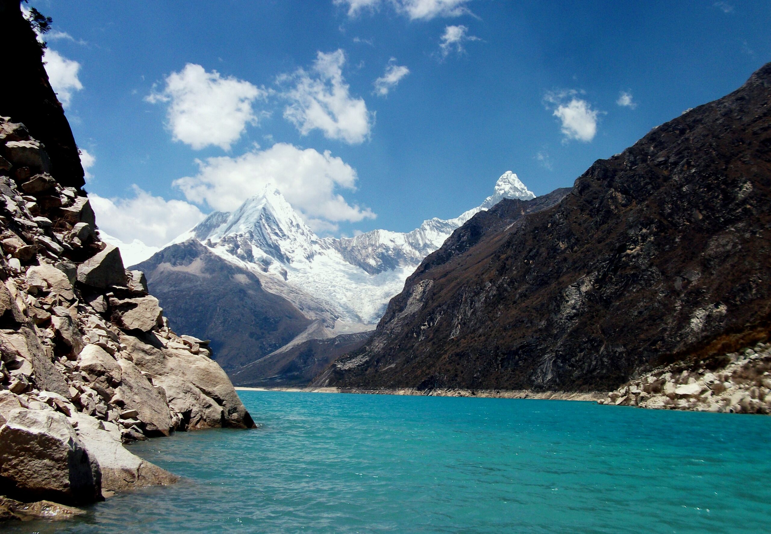
Huascaran is the highest mountain in Peru and the fourth-highest peak in the Western Hemisphere, a glaciated twin-summit massif rising to 6,768 m (22,205 ft) in the Cordillera Blanca. Its technical grade reads moderate (PD+ to AD), but altitude, objective hazard, and a seismic history that produced the deadliest debris avalanche ever recorded make it a serious expedition. This guide covers the Garganta normal route, 2026 costs, acclimatization, the mountain’s history from Annie Peck’s 1908 first ascent to the 1970 Yungay catastrophe, and who is ready to climb it.
A serious high-altitude expedition that punishes shortcuts.
The PD+/AD grade describes technical difficulty in good conditions. It does not capture the altitude exposure at 6,768 m, the serac and avalanche hazard on the normal route, or the physiological demands of multi-week climbing above 6,000 m. A July 2016 avalanche killed four of nine climbers on the standard route.
Climb Huascaran only with: prior experience above 5,500 m (Aconcagua, Mera Peak, Island Peak, or comparable), a certified AGMP or IFMGA guide with current Cordillera Blanca knowledge, comprehensive evacuation insurance, and a full acclimatization ladder. Without that profile, build up on easier Andean peaks first.
Huascaran at a glance
The essential numbers for Peru’s highest peak, the world’s tallest tropical mountain.
Find Hotels, Flights & Trips for the World’s Best Hiking Destinations
The Global Summit Guide Travel Shop on Expedia — curated for outdoor adventurers, mountaineers, and serious hikers. Patagonia to the Alps. Nepal to the Rockies. Curated lodging for every region we cover.
Explore Travel Shop on Expedia →| Summit elevation | 6,768 m (22,205 ft) – Huascaran Sur, highest peak in Peru |
| Twin summits | Huascaran Sur (6,768 m, higher) and Huascaran Norte (6,654 m), separated by La Garganta col at 6,010 m |
| Prominence | 2,776 m – qualifies as an “Ultra” prominence peak |
| Location | Cordillera Blanca, Yungay Province, Ancash Region, northern Peru |
| Coordinates | 9.1217 S, 77.6042 W |
| Rank | Highest in Peru; 4th highest in the Western Hemisphere (after Aconcagua, Ojos del Salado, Monte Pissis); tallest tropical mountain on Earth |
| National park | Huascaran National Park; UNESCO World Heritage Site (1985); UNESCO Biosphere Reserve (1977) |
| First ascent (Norte) | September 2, 1908 – Annie Smith Peck, Rudolf Taugwalder, Gabriel Zumtaugwald (first ascent of the peak) |
| First ascent (Sur) | July 20, 1932 – German-Austrian expedition led by Philipp Borchers |
| Alpine grade | PD+ to AD on the French Alpine system (varies by conditions) |
| Standard duration | 14-21 days including acclimatization; the technical climb itself is 5-7 days |
| Best season | June through September (Andean dry season); July-August optimal |
| 2026 cost range | $2,500-$6,500 per climber for a guided expedition from Huaraz |
| 1970 disaster | May 31, 1970 – Ancash earthquake triggered the deadliest landslide in recorded history; ~20,000-30,000 deaths in Yungay alone |
Why Huascaran demands more respect than its “PD+” grade suggests
The grade is accurate in narrow technical terms, but misleading as a full safety assessment. Three factors raise the real difficulty far above the number.
Altitude is the primary filter
At 6,768 m, Huascaran places climbers at roughly 41% of sea-level atmospheric pressure. It is higher than any peak in North America (Denali, 6,190 m), higher than every peak in the Alps (Mont Blanc, 4,809 m), and within 200 m of the 7,000 m threshold that defines expedition-grade Himalayan climbing. The technical climbing is moderate, but the altitude exposure is severe. Climbers without prior experience above 5,500 m face real risk of HAPE, HACE, and severe AMS in a place where rescue is far more complicated than on European or North American peaks. Most operators require prior 5,500 m experience, which by itself filters out most first-time high-altitude climbers.
The objective hazards are real
The normal route via La Garganta crosses sustained crevasse fields, several serac danger zones, and avalanche-prone slopes that have produced modern fatalities. The July 20, 2016 avalanche at about 5,800 m killed four climbers from a party of nine on the standard route. Glacier conditions shift fast during the season: seracs stable in June can collapse by August, and reliable crevasse bridges in early July can fail by late August. The icefall between Camp 1 and Camp 2 is the crux of the hazard, with large crevasses, steep ice steps to 60-70 degrees, and serac collapse risk. Teams move through it before dawn, when cold stabilizes the snow, which means 02:00-03:00 starts and the toll of repeated early mornings at altitude.
The seismic reality
The 1970 Ancash earthquake showed that Huascaran is not only a climbing objective but a geological feature in an active seismic zone capable of catastrophic mass-wasting. The disaster began at the north peak when shaking released an ice-and-rock mass roughly 910 m wide and 1.6 km long. The resulting avalanche traveled about 18 km and buried the town of Yungay in three minutes. Modern climbers face essentially zero probability of being on the mountain during a comparable event on their specific expedition, but the 1970 catastrophe shapes Peruvian alpine culture, park management, and the conservative risk approach that experienced Cordillera Blanca guides bring to the mountain.
Who can realistically climb Huascaran?
Huascaran is not a beginner objective. Knowing who it suits, and who should build experience first, helps you make a realistic decision.
Huascaran is appropriate for:
Climbers with prior experience above 5,500 m and multi-day expedition history. The standard prerequisite is a prior summit above 5,500 m, typically Aconcagua (6,961 m), Mera Peak (6,476 m), Island Peak (6,189 m), or comparable. You should be comfortable with the full expedition format: multiple high camps, tent life at altitude, roped glacier travel, and multi-week mountain time.
Cordillera Blanca regulars completing the high-altitude progression. Climbers who have built experience on Pisco (5,752 m), Ishinca (5,530 m), Vallunaraju (5,686 m), Tocllaraju (6,032 m), or Chopicalqui (6,354 m) have the regional knowledge that makes Huascaran a natural next step. The Cordillera Blanca offers one of the world’s best high-altitude progressions within a 30-mile radius.
Aconcagua veterans seeking technical progression. Aconcagua is higher but technically easier (PD on the normal route). Climbers who have summited it and want to keep the altitude while gaining glacier technique often choose Huascaran. The 200 m altitude reduction is offset by more demanding climbing.
Climbers preparing for Himalayan expeditions. Huascaran’s altitude provides experience for the 6,500-7,500 m band of smaller Himalayan peaks (Ama Dablam, Baruntse, Manaslu) and for first-time 8,000 m climbers.
Huascaran is not appropriate for:
Climbers without prior experience above 5,500 m. This is not a “first 6,000 m peak.” Attempting it without prior 5,500 m exposure raises AMS, HAPE, and HACE risk and removes the practical altitude tolerance that builds across repeated exposures.
Climbers with cardiovascular disease or uncontrolled hypertension. The altitude produces heavy cardiac stress. Anyone with prior cardiac events, arrhythmias, uncontrolled hypertension, or serious respiratory history should consult a cardiologist and altitude-medicine specialist first.
Climbers booking single-week trips without flexibility. Huascaran needs 14-21 days minimum for acclimatization and weather windows. Compressed schedules under 14 days raise AMS risk and cut summit success. No 6,500 m+ peak fits a single week.
Climbers choosing the cheapest operator without due diligence. Some Huaraz operators discount by cutting guide quality, equipment standards, and crew wages. The 2016 avalanche involved climbers from multiple operators, showing that operator quality matters for hazard management. Verify AGMP certification, current route knowledge, and safety records before booking.
Huascaran’s role in the Andes progression
Huascaran is the technical 6,768 m objective that bridges Aconcagua-style altitude climbing and Himalayan technical glaciated peaks.
| Stage | Peak / experience | Elevation | Why this position |
|---|---|---|---|
| Foundation | Easy Andean peaks (Pisco, Ishinca, Vallunaraju) | 5,530-5,752 m | First 5,000 m+ glaciated experience |
| Step up | Tocllaraju, Vallunaraju Norte | 5,686-6,032 m | First 6,000 m peaks; more sustained glacier travel |
| Intermediate | Aconcagua (normal route) | 6,961 m | First major 6,500 m+ peak; expedition format; lower technical demand |
| Technical 6,000 m | Huascaran (Garganta normal route) | 6,768 m | First seriously technical 6,500 m+ peak; sustained glacier complexity |
| Andean apex | Chopicalqui, Artesonraju, Alpamayo | 5,947-6,354 m | Technical Andean ice and mixed routes |
| Himalayan bridge | Mera Peak, Island Peak, Ama Dablam | 6,189-6,812 m | Himalayan technical 6,000 m peaks |
| 8,000 m entry | Manaslu, Cho Oyu, Shishapangma | 8,000 m+ | First 8,000 m expeditions |
The Cordillera Blanca offers a uniquely concentrated progression: climbers can complete the foundation through Andean-apex stages within a single 6-8 week trip to Peru, which makes Huaraz one of the world’s best high-altitude training bases.
Who was the first woman to climb Huascaran?
Peru’s highest peak carries one of the landmark stories in women’s mountaineering.
The first woman to climb Huascaran was American mountaineer Annie Smith Peck, who reached the summit of Huascaran Norte (6,654 m) on September 2, 1908, at age 58, guided by Swiss alpinists Gabriel Zumtaugwald and Rudolf Taugwalder. Her climb was also the peak’s first ascent by anyone, and set a Western Hemisphere altitude record for its time.
Peck’s summit was the payoff of nearly a decade of effort. Born in Providence, Rhode Island in 1850, she came to serious mountaineering late, climbing the Matterhorn in 1895 and Mexico’s Pico de Orizaba in 1897, the latter then the highest ascent in the Americas by a woman. From 1903 she made repeated trips to the Andes hunting for a peak on which she could claim a genuine first ascent, and Huascaran became the target. Poorly funded and often reliant on local porters, she failed on attempt after attempt from 1904 through 1906. Only in 1908, with two experienced Swiss guides, did the north peak finally go.
The climb itself was close to disastrous. On the ascent a guide lost Peck’s insulated mittens down the mountain, and she finished the summit day with her hands tucked under a woollen poncho to fend off frostbite. She believed at the time that Norte was the higher of Huascaran’s two summits and that she had broken the world altitude record for a woman. Later surveys showed Huascaran Sur (6,768 m) to be higher, and the elevation lower than she had estimated, but her achievement stood: the first ascent of a major Andean 6,000 m peak, and the highest point reached by any climber in the Western Hemisphere at that date.
Peck the suffragist, and the banner that was not on Huascaran
Peck was a determined suffragist who treated hard climbing as an argument in itself: proof, as she put it, that a woman’s work could stand beside a man’s. Her Huascaran ascent belonged to that campaign. The detail often attached to this climb, the “Votes for Women” pennant, actually came three years later. In 1911, at 61, she climbed Peru’s Coropuna and left a banner reading “Joan of Arc Suffrage League – Votes for Women” at its summit. It is worth getting right, because the two climbs are frequently merged into one story. On Huascaran, the statement was the climb itself.
Legacy
Peck kept climbing into her eighties, and her Andean record made her one of the best-known American climbers of her generation. In 1927 the Lima Geographical Society honoured her by naming Huascaran’s north peak Cumbre Aña Peck, the summit she had been first to reach. The historic north-peak line she pioneered still exists as the rarely-travelled Garganta route to Huascaran Norte, though almost everyone now continues to the higher Sur summit instead.
The 1908 climb reached Huascaran Norte (6,654 m), the north peak, not the higher Huascaran Sur (6,768 m), which was first climbed in 1932. The “Votes for Women” banner belongs to Peck’s 1911 Coropuna climb, not Huascaran.
Huascaran history: from Peck’s 1908 ascent to the 1970 catastrophe
The mountain’s documented history spans 118 years, defined by two threads: pioneering early alpinism, and the 1970 debris avalanche that reshaped Peruvian disaster culture.
Indigenous recognition and the Quechua name
The peak has been recognized in Quechua culture for centuries. The names “Waskaran” (Hispanized to Huascaran) and “Mataraju” both reference its twin-summit profile, visible from the Callejon de Huaylas valley below. Spanish observers first saw the peak in 1533, but no European climbing attempts followed for nearly four centuries.
First ascent of Huascaran Norte – Annie Peck and Swiss guides
Annie Smith Peck, then 58, reached the summit of Huascaran Norte (6,654 m) with Swiss guides Rudolf Taugwalder and Gabriel Zumtaugwald. It was the peak’s first recorded ascent and a landmark in women’s mountaineering, widely covered in the international press. Peck believed Norte was the higher summit; only later was Sur confirmed as higher.
Failed attempts on Huascaran Sur
The 24 years before the successful Sur ascent saw multiple European and American attempts turned back by crevasse hazard, weather, and inadequate acclimatization. The accumulated route knowledge eventually enabled the 1932 climb.
First ascent of Huascaran Sur – German-Austrian expedition
The true highest summit (6,768 m) was first climbed by a German-Austrian team led by Philipp Borchers, including Erwin Schneider, Hermann Horlin, Erwin Hein, and Wilhelm Bernard, via what became the normal route through La Garganta. The expedition also produced the first accurate map of the Cordillera Blanca, the Alpenvereinskarte, which remained the definitive regional reference for decades.
First major avalanche – Ranrahirca
On January 10, 1962, a rock-and-ice avalanche from the north peak destroyed the village of Ranrahirca and killed roughly 4,000 people. It demonstrated that the north peak’s glacier was unstable, a warning local authorities suppressed. It would prove tragically prescient eight years later.
The Ancash earthquake and the world’s deadliest avalanche
At 15:23 local time, a magnitude 7.9 undersea earthquake struck off Peru’s coast. The shaking released a glacial ice-and-rock mass about 910 m wide and 1.6 km long from Huascaran’s north face. The debris avalanche traveled roughly 18 km at speeds reaching 335 km/h and buried the town of Yungay in about three minutes on a Sunday market day. Around 20,000-30,000 people died in Yungay alone, with only 200-400 survivors who reached the cemetery hill. Total earthquake-and-avalanche deaths across Ancash reached an estimated 66,000-70,000. It remains the deadliest landslide in recorded history; the buried town is now the “Campo Santo” memorial.
National park and UNESCO designations
Huascaran National Park was established in 1975, protecting about 340,000 hectares of the Cordillera Blanca. UNESCO named the region a Biosphere Reserve in 1977 and inscribed the park as a World Heritage Site in 1985. The park also shelters endangered wildlife including the spectacled bear, Andean condor, puma, and vicuna.
Normal route avalanche – four killed
Exactly 84 years to the day after the Sur first ascent, an avalanche at about 5,800 m caught a party of nine climbers on the normal route and killed four. The tragedy renewed conservative practices among Huaraz operators and reinforced the value of pre-dawn timing and active glacier monitoring.
Modern climbing period
Climbing volume recovered from COVID-era disruption, and Huascaran remains the most-climbed major Andean peak after Aconcagua. Glacier retreat continues to shift route conditions, especially in the Camp 1 to Camp 2 icefall, and guide services increasingly emphasize daily glacier assessment. The May 31 disaster anniversary is observed nationally as Natural Disaster Education and Reflection Day.
The routes of Huascaran
One route dominates. About 95% of summit attempts use the Garganta normal route; the rest are rarely-climbed technical lines.
1. Garganta normal route to Huascaran Sur
The standard line from Musho (~3,000 m) ascends through base camp (~4,200 m), Camp 1 (~5,300 m), and Camp 2 at La Garganta col (~6,010 m, the saddle between the two summits), then to the Sur summit at 6,768 m. Difficulty ranges PD+ to AD depending on glacier conditions, with the icefall between Camp 1 and Camp 2 as the crux hazard: large crevasses, ice steps to 60-70 degrees, and serac risk. A typical climbing schedule: Day 1 Musho to base camp; Day 2 acclimatization; Day 3 to Camp 1; Day 4 through the icefall to Camp 2 (the most dangerous day, a pre-dawn start); Day 5 summit and descend to Camp 1; Days 6-7 descent to Musho and return to Huaraz.
2. Garganta route to Huascaran Norte
The original 1908 route follows the same approach through base camp, Camp 1, and Camp 2, then diverges at La Garganta to climb the north peak (6,654 m) rather than the south. It grades around PD+ and is technically easier than the Sur ascent in good conditions. Most modern climbers target Sur for its status as Peru’s highest point; Norte climbs are typically done by those retracing Peck’s route or by Cordillera Blanca completionists.
3. West Face / Ridge (“The Shield”)
The Shield ascends the western face of Huascaran Sur via sustained ice and mixed climbing on steep terrain, with serac hazard above the route. It suits experienced alpinists with prior D+ Andean experience and the skills to manage sustained 50-70 degree ice with mixed rock. Commercial operators rarely guide it; most attempts are by independent technical climbers.
4. South Face and East Face technical routes
The south and east faces host multiple technical lines from D+ to TD, reserved for elite alpinists with sustained ice and mixed experience. They see minimal traffic, often with multi-year gaps between ascents, and are climbed for their technical character rather than the summit. New-route attempts continue periodically as elite climbers explore the mountain’s unclimbed potential.
The Huascaran summit day, hour by hour
Summit day from Camp 2 at La Garganta (6,010 m) is the most demanding part of the expedition: about 760 vertical metres to the top and back across 8-10 hours at extreme altitude.
La Garganta (6,010 m) is one of the highest standard sleep elevations of any commonly climbed peak, higher than Aconcagua’s Camp Colera and approaching Himalayan high camps. Expect sleep disruption, appetite loss, and reduced cognition. Diamox prophylaxis (acetazolamide, 125-250 mg twice daily started days before), hydration, and the discipline to leave on time despite poor sleep are essential. Most Huascaran fatalities involve climbers who pushed for the summit through clear AMS symptoms at Camp 2. Turning back is the correct call when symptoms develop.
Huascaran costs in 2026
Costs range from about $2,500 with budget Huaraz operators to $7,000+ with premium international outfits, for the same fundamental mountain.
| Tier | 2026 price | What’s included |
|---|---|---|
| Budget Peruvian (Huaraz-based) | $2,500-$3,500 | AGMP guide(s), basic camping gear, base-camp logistics, donkey transport, basic food; verify safety-equipment standards |
| Mid-range Peruvian | $3,500-$5,000 | Experienced AGMP guides, quality gear, full crew, hot meals, pre-climb hotel, acclimatization climbs (Pisco or Ishinca) included |
| Premium international | $5,000-$7,000+ | Western IFMGA lead guide plus local AGMP guides, premium camp setup, insurance review, full acclimatization program |
| Luxury / boutique | $7,000-$12,000+ | Boutique base camp, 1:1 or 1:2 guide ratios, complete equipment provision, customized acclimatization |
| Cost component | 2026 amount (USD) |
|---|---|
| Operator package (mid-range, 14-21 days) | $3,500-$5,000 |
| International flights to Lima | $800-$2,000 |
| Lima-Huaraz transport | $50-$150 |
| Huaraz hotels (pre/post climb) | $100-$300 |
| Huascaran National Park entry fee | $25-$40 |
| Personal gear rental (if needed) | $200-$500 |
| Tips for guides and porters | $200-$400 |
| Travel insurance with high-altitude evacuation | $200-$500 |
| Total realistic 2026 trip budget | $5,500-$9,500 mid-range (budget $4,000-$6,500; premium $8,000-$14,000+) |
Huascaran’s cost profile is lower than comparable objectives. Its no-permit-fee structure (only a modest park fee), strong Huaraz infrastructure, and accessible logistics make it one of the most economical 6,500 m+ expeditions in the world, particularly for climbers prioritizing technical altitude experience.
Planning the trip?
Get your insurance and acclimatization sorted early: read the mountaineering insurance guide for 6,000 m+ peaks and acclimatization explained, and compare how to choose an operator. For flights and lodging in Huaraz and Lima, compare options through the Global Summit Guide Expedia travel shop.
Disclosure: the Expedia link is an affiliate link; we may earn a small commission at no extra cost to you, and it never affects our recommendations.
Insurance Guide Choose an OperatorHuascaran gear checklist
Requirements span the full high-altitude expedition range: cold to -25 C and below, glaciated terrain, sustained camping at 5,300-6,010 m, and 14-21 day durability. Operators usually provide group gear (rope, screws, slings) and offer rental for personal items.
Climbing equipment
Double-boot mountaineering boots rated for 6,000 m+ (La Sportiva Spantik, Scarpa Phantom 6000, or equivalent); 12-point steel crampons with anti-balling plates matched to your boots; a general mountaineering ice axe (50-65 cm); alpine harness; UIAA-certified helmet (essential in the icefall and serac zones); 4-5 locking carabiners; belay device; and prusiks plus crevasse-rescue gear (often guide-supplied). See the full crampons guide and boots guide for selection detail.
Clothing system
Base layers (2-3 sets, merino or synthetic); mid insulation (fleece and insulated pants); a heavy down or synthetic jacket rated to -25 C equivalent; hard-shell jacket and pants; soft-shell pants for daily wear; warm hat and balaclava; a glove system (liners plus insulated summit mittens); 4-5 pairs of merino socks with liners; and snow gaiters. The high-altitude layering guide covers the full system.
Pack, sleep, and personal
A 90-120 L duffel for porter carry, a 45-65 L climbing pack, a sleeping bag rated to -25 C minimum (-30 C recommended for Camp 2), a liner, insulated pad and 4-season tent (usually operator-supplied); insulated 3 L water capacity and a 1 L thermos; energy food from home; Diamox (physician-directed); a personal first-aid kit; SPF 50+ sunscreen and lip balm; Category 4 glacier glasses; a headlamp with cold-resistant lithium spares; and trekking poles.
When to climb Huascaran: season by season
The season is defined by the Andean dry season, narrower and more time-sensitive than mid-latitude Alpine windows.
June – early dry season
The first solid month as the wet season recedes. Conditions are usually excellent: stable weather, cold temperatures firming the glacier, manageable crevasse fields. Trade-offs are occasional leftover wet-season snowfall and slightly less reliable weather windows than the peak months.
July-August – peak season
The most reliable weather windows, most stable glacier conditions, and full operator infrastructure. Trade-offs are heavy booking competition, crowded camps, and the need to pre-book premium operators 3-6 months ahead. The 2016 avalanche occurred in this window, a reminder that objective hazard persists even in optimal conditions.
September – late dry season
A strong window with cooler temperatures and fewer crowds than August. Weather windows become more variable as the wet season approaches and some operators wind down, but September can be the preferred month for climbers who value solitude over absolute reliability.
October-May – wet season (not recommended)
Frequent snowfall destabilizes the glacier, crevasse bridges become unreliable, weather windows disappear, and most reputable operators do not run expeditions. El Nino years (most recently 2023-2024) can compromise conditions even during the standard dry-season window, so check ENSO forecasts when planning.
Huascaran FAQ
The questions climbers and researchers ask most.
Who was the first woman to climb Huascaran?
American mountaineer Annie Smith Peck, who reached Huascaran Norte (6,654 m) on September 2, 1908, at age 58, guided by Swiss alpinists Gabriel Zumtaugwald and Rudolf Taugwalder. It was also the peak’s first ascent by anyone, and set a Western Hemisphere altitude record for the time. Huascaran Sur (6,768 m) was first climbed in 1932.
Was Annie Smith Peck a suffragist?
Yes. Peck treated high climbing as proof that women were the equal of men, and her 1908 Huascaran ascent was part of that mission. In 1911 she climbed Peru’s Coropuna and left a “Votes for Women” pennant at the summit, a banner often wrongly attributed to Huascaran but actually placed on Coropuna.
How much does it cost to climb Huascaran in 2026?
About $2,500-$6,500 per climber for a 14-21 day guided program from Huaraz, depending on operator tier. Local Peruvian operators charge $2,500-$4,000; international operators $5,000-$7,000. With flights and transport a full trip budget usually runs $4,000-$9,000. The national park fee is only $25-$40; there is no large permit fee.
How dangerous is Huascaran?
More dangerous than its PD+/AD grade suggests, from extreme altitude, serac and avalanche hazard, and the seismic instability shown in 1970. A July 2016 avalanche killed four of nine climbers on the normal route. The 1970 Ancash earthquake triggered the deadliest debris avalanche in recorded history, killing roughly 20,000-30,000 people in Yungay alone. Climb only with prior high-altitude experience, a certified guide, and full acclimatization.
What is the best route to climb Huascaran?
The Garganta normal route via La Garganta from Musho, used by about 95% of summit attempts. It ascends from Musho (~3,000 m) through base camp (~4,200 m), Camp 1 (~5,300 m), and Camp 2 at La Garganta (~6,010 m) to the 6,768 m summit, graded PD+ to AD. For nearly all climbers this is the right objective; the West Face (D+) and the south and east face lines (D+ to TD) are for elite alpinists.
When is the best time to climb Huascaran?
June through September, with July-August the peak. This Andean dry season gives stable weather and the most reliable glacier conditions. June is excellent and quieter; September stays climbable with fewer crowds. October through May is the wet season and is not recommended. El Nino years can shift conditions.
What happened in the 1970 Huascaran disaster?
On May 31, 1970, a magnitude 7.9 earthquake off Peru’s coast destabilized Huascaran’s north face, releasing an ice-and-rock mass that became a debris avalanche traveling about 18 km at speeds reaching 335 km/h. It buried the town of Yungay in three minutes. Roughly 20,000-30,000 died in Yungay alone, with total regional deaths estimated at 66,000-70,000. It remains the deadliest landslide in recorded history; the buried town is now the Campo Santo memorial.
Do I need experience above 5,500 m to climb Huascaran?
Most reputable operators require it, typically a prior summit like Aconcagua (6,961 m), Mera Peak (6,476 m), Island Peak (6,189 m), or a Cordillera Blanca peak such as Tocllaraju (6,032 m). Some operators build the required experience on Pisco (5,752 m) and Ishinca (5,530 m) before Huascaran during the same trip.
How does Huascaran compare to Aconcagua?
Aconcagua (6,961 m) is 193 m higher but technically easier, climbed mostly on trail and scree at PD. Huascaran (6,768 m) is lower but more technical (PD+ to AD), with sustained glacier travel, icefall, and crevasse fields. Many climbers do Aconcagua first for altitude and expedition experience, then Huascaran for technical progression.
Methodology & sources
- SERNANP and Huascaran National Park – official climbing permit and park information.
- Asociacion de Guias de Montana del Peru (AGMP) – professional guiding standards.
- INAIGEM – Cordillera Blanca glacier monitoring; UNESCO World Heritage documentation (1985); USGS analysis of the 1970 Ancash earthquake and avalanche.
- Historical detail on the 1908 first ascent cross-checked against Britannica, the American Alpine Club Library, Women in Exploration, and Annie S. Peck, “A Search for the Apex of America” (1911).
- Current operator route and pricing reports; news coverage of the July 20, 2016 avalanche (Reuters, BBC, El Comercio). Safety framing reviewed by Dawson Ludlow.
Last updated: July 18, 2026 · next review October 2026 (mid-season conditions check).
Confidence: High on history, routes, and grades; Medium on 2026 operator pricing, which moves by season.Build up to Huascaran the right way
Peru’s highest peak rewards climbers who arrive with prior altitude, a certified guide, a full Cordillera Blanca acclimatization ladder, and the discipline to turn around. Treat the grade as the floor of the difficulty, not the ceiling.
Andes Progression Plan Which Mountain Should You Climb?Was this helpful?
🏔Related peaks nearby
🧭Explore & compare
Global Summit Guide is an independent mountaineering resource founded in 2026. The team combines first-hand trekking and climbing experience with in-depth research and professional health and nutrition review to help climbers choose objectives, prepare properly, and stay safe.
Health, altitude, and nutrition content is reviewed by Taylor Ludlow (Registered Nurse) and Brigg Hoopes (Nutritionist).
What We Don't Know Yet
Mountain information changes quickly. This box explains the limits of what this page can responsibly promise.
- Permit availability, reservation windows, quotas, and official fee rules may change after this page is updated.
- Guide-company prices, departure dates, guide ratios, included services, and cancellation rules can change without notice.
- Weather, snowpack, avalanche risk, road access, and route conditions can change quickly and may be different on your climbing dates.
- Route conditions, trailhead access, crevasse exposure, stream crossings, and rescue access may vary from published planning guidance.
- Total trip cost can change with flights, lodging, guide pricing, permits, gear rentals, transportation, and exchange rates.
Verify current conditions with official land managers, guide services, local forecasts, and current route reports before booking or climbing.
Part of this Global Summit Guide cluster
Explore the complete Mountains guide for more context, routes, planning links, and related resources.
Mountaineering, rock and ice climbing, glacier travel, and high-altitude activity are inherently dangerous and can result in serious injury or death. The information on Global Summit Guide is provided for general informational and educational purposes only and is not a substitute for professional instruction, qualified guiding, proper equipment, or your own judgment and experience.
Route conditions, weather, snowpack, permits, regulations, and hazards change constantly and may differ from what is described here. Details may be incomplete, out of date, or contain errors. Always verify current information with local authorities, certified guides, and official sources before making any decision in the mountains.
Nothing on this site is medical, legal, or financial advice. Our fitness, acclimatization, altitude, and nutrition content is general in nature; consult a qualified physician before beginning any strenuous exercise program or exposing yourself to high altitude.
You are solely responsible for your own safety and decisions. To the fullest extent permitted by law, Global Summit Guide and its team accept no liability for any loss, injury, damage, or expense arising from use of, or reliance on, this information. By using this site you acknowledge these risks and accept these terms.
Some links on this site may be affiliate links. If you buy through them we may earn a small commission at no extra cost to you; this never affects our recommendations.
Global Summit Guide recommendation path
Next Best Mountain to Research
Use these recommendations to continue the right planning path instead of stopping on one page.
Use current permit, weather, route, and operator information before booking or climbing.