
Last updated July 10, 2026
Climbing Chimborazo: Ecuador’s Highest Peak & the Closest Point to the Sun
Chimborazo isn’t the tallest mountain above sea level — but its summit is the farthest point on Earth’s surface from the planet’s center, and the closest point on Earth to the sun. It’s also the most affordable 6,000-metre summit in the world: a moderate glacier climb reachable in a single week from Quito. Here’s how to do it.
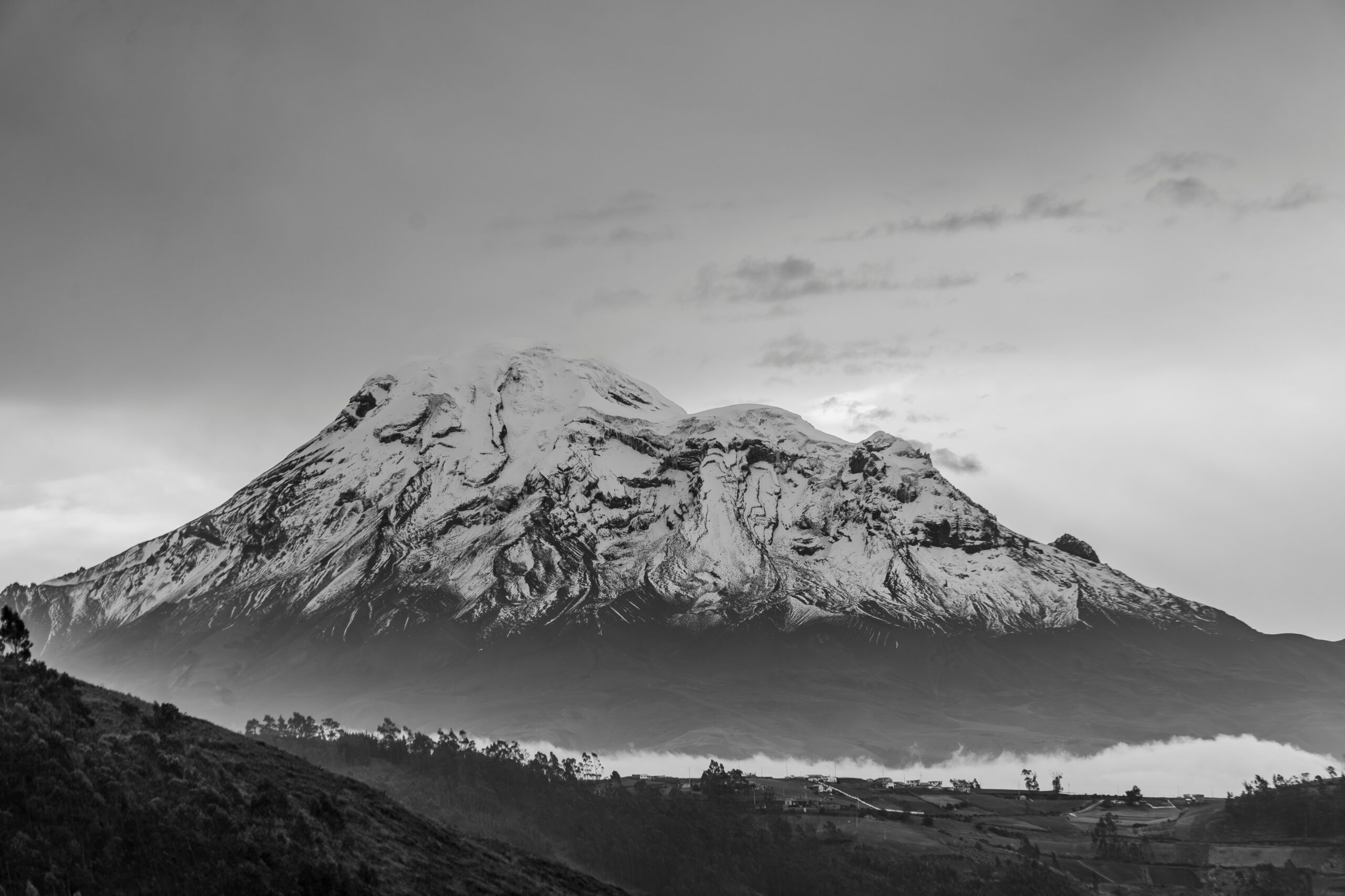
Chimborazo (6,263 m) is Ecuador’s highest mountain and — thanks to the equatorial bulge — the point on Earth’s surface farthest from the planet’s center. As a climb it’s a moderate but serious glacier ascent: crampons, ice axe, roped teams, and about 1,400 m of ascent on a midnight-to-dawn summit push. No hard technical climbing, but real altitude, rockfall, and crevasses.
Two rules shape every trip. First, a certified guide is mandatory — Ecuador has required one on its glaciated volcanoes since 2012. Second, acclimatization is everything: almost nobody summits straight off the plane, so Chimborazo is climbed at the end of a 7–10 day Ecuadorian volcano progression. Do that, and it’s the cheapest true 6,000er on Earth.
On this page
Where it is
Central Ecuadorian Andes — staged from Riobamba, about 150 km south of Quito.
Find Hotels, Flights & Trips for the World’s Best Hiking Destinations
The Global Summit Guide Travel Shop on Expedia — curated for outdoor adventurers, mountaineers, and serious hikers. Patagonia to the Alps. Nepal to the Rockies. Curated lodging for every region we cover.
Explore Travel Shop on Expedia →Chimborazo dominates the central Ecuadorian highlands in the Western Cordillera, about 150 km south-southwest of Quito and roughly 30 km northwest of Riobamba, the standard staging town. The climb is accessed through the Chimborazo Wildlife Production Reserve via the community of Pulingue San Pablo, with a road running right up to the Carrel refuge at about 4,850 m.
The mountain, in brief
A giant, dormant volcano that’s sacred to the people who live beneath it.
Chimborazo is a dormant stratovolcano — its last confirmed eruption was around 550 CE — rising to 6,263 m (20,548 ft), the highest point in Ecuador. A 2016 GPS survey by the French IRD and the Ecuadorian Military Geographic Institute fixed the summit at 6,263.47 m. The massif carries several summits linked by a ridge the locals call the Arista del Sol (Sun’s Ridge); the true high point is the Whymper summit, with the slightly lower Veintimilla summit (6,230 m) reached first on the standard route.
To the Quechua communities around it, the mountain is Taita Chimborazo — “Father Chimborazo” — a sacred apu honoured in ceremonies that long predate any Western ascent. It sits at the heart of the Chimborazo Wildlife Production Reserve (established 1987, ~58,560 ha), where reintroduced vicuñas graze the high páramo. Climbers should recognise they’re visiting a peak that remains actively sacred to its Indigenous neighbours.
The closest point to the sun
Why a 6,263 m peak beats an 8,849 m one.
Chimborazo’s famous claim sounds like a trick, but it’s simple geometry. Earth isn’t a perfect sphere — it’s an oblate spheroid, bulging at the equator because of its spin. Sea level at the equator sits about 21 km farther from Earth’s center than sea level at the poles. Chimborazo sits almost on the equator (1°28′ S), so its whole mass rides that bulge:
| Measure | Chimborazo | Everest |
|---|---|---|
| Height above sea level | 6,263 m | 8,849 m |
| Latitude | 1°28′ S (equator) | 27.6° N |
| Distance from Earth’s center | ~6,384.4 km | ~6,382.3 km |
The equatorial bulge more than makes up for Everest’s extra 2,586 m of height: Chimborazo’s summit ends up about 2.1 km farther from Earth’s center than Everest’s. That makes it the point on Earth’s solid surface closest to the sun, the moon, and outer space — and the fastest-moving point on the planet’s surface as Earth rotates. Several other near-equatorial Andean peaks come remarkably close (Huascarán Sur in Peru is nearly tied), but Chimborazo’s near-perfect equatorial position keeps it first. Everest, for all its height, doesn’t crack the top twenty by this measure. Both records are valid — Everest is the highest mountain; Chimborazo is the farthest from Earth’s center.
Chimborazo vs Everest
Two different mountains for two different climbers.
| Dimension | Chimborazo | Everest |
|---|---|---|
| First ascent | 1880 — Whymper & the Carrel brothers | 1953 — Hillary & Tenzing |
| Technical difficulty | Moderate glacier travel | Severe technical + extreme altitude |
| Time on the mountain | Summit push within a 7–10 day trip | 50–60 day expedition |
| Success rate | ~40–60% | ~55–60% |
| Typical cost | ~$2,500–$5,000 total | ~$45,000–$85,000 |
| Permit | No climbing permit; small reserve fee | ~$11,000 permit + fees |
The honest take: Everest is a life-commitment expedition for elite budgets and serious risk tolerance; Chimborazo is a week-long guided climb for fit recreational mountaineers at a fraction of the cost. The “which is tallest” debate is really a question of definitions — and Chimborazo gives ordinary climbers a real 6,000er with a one-of-a-kind geographic credential.
History: Humboldt & Whymper
Once believed the tallest mountain on Earth.
For nearly 300 years after the Spanish arrived, Chimborazo was widely believed to be the highest mountain in the world — a reputation that lasted until the Himalaya were properly surveyed in the mid-1800s. In 1802, the German naturalist Alexander von Humboldt, with Aimé Bonpland and Carlos Montúfar, climbed to about 5,875 m before a crevasse turned them back — the highest any human had verifiably reached at the time, a record Humboldt held for over 30 years. The data he gathered helped found modern biogeography and later inspired Darwin.
The first ascent came on 4 January 1880, when English mountaineer Edward Whymper — of Matterhorn fame — reached the top with the Italian guides Jean-Antoine and Louis Carrel. They first stood on the Veintimilla summit; Whymper returned in July 1880 to complete the traverse to the true high point, the Whymper summit or Cumbre Máxima, establishing the line still followed today. The two refuges on the mountain — Hermanos Carrel and Whymper — are named for that expedition.
The climb: the El Castillo route
The current normal line — and why it replaced the old direct route.
El Castillo Ridge
The El Castillo Ridge is now the standard route, reached from the Carrel refuge on the mountain’s southwest side. It gains the Castillo saddle beside the prominent El Castillo rock tower, then climbs the Thielmann Glacier and a broad glaciated ridge to the Veintimilla summit before a short traverse to the true Whymper summit. It’s roped glacier travel on 30–45° slopes with real crevasse hazard — moderate, not extreme, but sustained and high.
The standard progression
| Carrel refuge | ~4,850 m · road end · base |
| High camp (El Castillo) | ~5,300 m · tents by the rock tower · summit-night staging |
| Castillo saddle | ~5,400 m · crampons on · rockfall zone (pass in the cold) |
| Thielmann Glacier | ~5,700–6,100 m · roped; crux of the route |
| Veintimilla summit | 6,230 m · false summit · many turn here in bad conditions |
| Whymper summit | 6,263 m · the true top; ~45 min traverse from Veintimilla |
Guides, permits & refuges
The one rule you can’t work around.
Since November 2012, Ecuador has legally required a certified mountain guide to climb its glaciated volcanoes, and on Chimborazo a qualified guide is mandatory above the Whymper refuge. Look for guides certified by ASEGUIM (the Ecuadorian mountain guide association) or IFMGA/UIAGM. You can hike freely to the lower Carrel refuge as a tourist, but the summit cannot be climbed unguided.
Refuges: Hermanos Carrel (~4,850 m) at the road end, and the higher Whymper refuge (~5,000 m), which has had periodic closures — many teams now use the fixed high camp near El Castillo (~5,300 m).
Camping: restricted; climbers sleep in the refuges or the designated high camp, not wherever they like.
Register: you check in with your passport at the reserve entrance.
Acclimatization (the real key)
Altitude, not technique, is what turns people back.
The single biggest predictor of success on Chimborazo isn’t strength or skill — it’s acclimatization. Climbers who arrive from sea level and try the summit within a couple of days fail the large majority of the time; those who follow a proper 7–10 day build-up summit far more often. That’s why Chimborazo is almost always climbed at the end of an Ecuadorian volcano progression, using the country’s “Avenue of the Volcanoes” as a natural staircase.
- Quito (2,850 m) — two nights to settle in.
- Pichincha or Pasochoa (~4,200–4,700 m) — a day hike above Quito.
- Illiniza Norte (5,126 m) — a non-technical scrambling summit.
- Cotopaxi (5,897 m) — a full glacier climb; the key rehearsal for Chimborazo’s terrain.
- Rest in Riobamba or Baños, then move to Chimborazo for the summit push.
Programs shorter than about a week have much lower success rates and aren’t recommended for a first 6,000er. Building Cotopaxi in first isn’t just for fitness — it’s the acclimatization that makes Chimborazo realistic.
What it costs in 2026
The cheapest real 6,000-metre summit on Earth.
| Option | 2026 price (per person) | Notes |
|---|---|---|
| Reserve entry | a few dollars | No climbing permit required |
| Single-summit guided (3–4 days) | $1,200–$2,000 | Guide, transport, refuge, gear if needed |
| Cotopaxi + Chimborazo (7–10 days) | $2,500–$4,500 | The recommended path for a first Andean 6,000er |
| Premium IFMGA expedition | $3,500–$6,000 | Smaller ratios, certified guides, extended acclimatization |
| Flights to Quito (from US) | $500–$1,200 | 5–8 hours; cheapest from Miami |
A complete trip typically lands around $2,500–$5,000 including flights — a fraction of Aconcagua ($4,000–$8,000), Mount Logan ($8,000+), or any Himalayan 6,000er. Add specialised travel insurance with high-altitude/rescue cover, since standard policies often exclude climbing above 4,500–6,000 m.
Weather & when to climb
Two dry windows, and a mountain that makes its own weather.
Being on the equator, Chimborazo has no real “summer” or “winter” — instead two drier climbing windows separated by wetter spells. The two best periods are December–February (often the most stable, with the firmest snow and highest success) and June–August (cooler and windier, with June–July strongest). March–May and September–November are wetter, with lower success rates. Because there’s little seasonal daylight change, weather can shift within hours rather than days, so guides watch short windows closely.
Riobamba — Chimborazo staging town (2,750 m)
Loading live data…Gear essentials
Full glacier kit — more than a volcano trek, less than a Denali expedition.
Operators usually provide the technical hardware (rope, and often crampons, ice axe, harness, helmet); you bring your own clothing system and boots. The core:
- Crampon-compatible mountaineering boots + 12-point steel crampons, ice axe, harness, helmet.
- Full layering system — base layers, insulating mid-layer, down jacket, and waterproof shell top and bottom; warm and summit-weight gloves plus mittens.
- Extreme sun protection — Category 4 glacier glasses and high-SPF sunscreen; equatorial-glacier UV is brutal.
- Headlamp + spare batteries for the 6+ hours of climbing in the dark, and an insulated bottle/thermos.
- A sleeping bag rated to about −15°C for the refuge/high camp, and any altitude medication your doctor advises.
Frequently asked questions
Is Chimborazo really the closest point to the sun?
Yes. Its summit is the farthest point on Earth’s surface from the planet’s center (~6,384.4 km vs Everest’s ~6,382.3 km) because of the equatorial bulge, making it the closest surface point to the sun and space — even though Everest is much higher above sea level.
Do you need a guide?
Yes — a certified ASEGUIM/IFMGA guide is mandatory to climb Ecuador’s glaciated volcanoes (a rule since 2012), and required above the Whymper refuge on Chimborazo. The lower Carrel refuge is open to independent visitors.
What’s the standard route?
The El Castillo Ridge: Carrel refuge (~4,850 m) → high camp (~5,300 m) → Castillo saddle → Thielmann Glacier → Veintimilla (6,230 m) → Whymper (6,263 m). It replaced the older direct line, which glacier retreat made rockfall-prone.
How hard is it?
Moderate but serious — roped glacier travel with crampons and ice axe, ~1,400 m of ascent on summit night, no hard technical climbing. Altitude, rockfall, crevasses, and cold are the real challenges. Success rates ~40–60%.
When is the best time?
December–February (often best) and June–August (June–July strongest). The wet shoulder seasons have lower success. Weather can change within hours near the equator.
How much does it cost?
The cheapest 6,000er anywhere: ~$2,500–$4,500 for a guided Cotopaxi + Chimborazo program, ~$1,200–$2,000 for a single-summit climb, plus flights. Just a small reserve fee, no climbing permit.
How we built this
Research-based. This guide is compiled from Ecuadorian guide-service and ASEGUIM references, SummitPost and Mountain Planet route descriptions, the 2016 IRD/IGM GPS survey, and current 2026 operator information, cross-checked for elevation, route status (the shift to the El Castillo Ridge), the mandatory-guide rule, and cost.
Glacier conditions on Chimborazo are changing quickly, and refuge availability, fees, and route specifics shift year to year. Treat everything here as planning background and confirm current details with a certified Ecuadorian operator before you climb.
Plan your closest-to-the-sun summit
Chimborazo is the most affordable 6,000er on Earth — but only with a certified guide and real acclimatization. Build up through Ecuador’s volcanoes, then stand on the point of Earth nearest the sun.
Andes High-Altitude Giants → Acclimatize on Cotopaxi →Was this helpful?
🏔Related peaks nearby
🧭Explore & compare
Global Summit Guide is an independent mountaineering resource founded in 2026. The team combines first-hand trekking and climbing experience with in-depth research and professional health and nutrition review to help climbers choose objectives, prepare properly, and stay safe.
Health, altitude, and nutrition content is reviewed by Taylor Ludlow (Registered Nurse) and Brigg Hoopes (Nutritionist).
What We Don't Know Yet
Mountain information changes quickly. This box explains the limits of what this page can responsibly promise.
- Visa, passport, vaccination, border, insurance, and local transportation rules may change before your trip.
- Route conditions, snowpack, closures, and weather can change quickly after this page is updated.
- Permit rules, fees, quotas, and reservation windows may change between review cycles.
- Operator availability, pricing, guide ratios, and cancellation terms can change by season.
- Your fitness, altitude response, risk tolerance, and experience level may change what is safe or realistic.
Verify current conditions with official land managers, guide services, local forecasts, and current route reports before booking or climbing.
Part of this Global Summit Guide cluster
Explore the complete Mountains guide for more context, routes, planning links, and related resources.
Mountaineering, rock and ice climbing, glacier travel, and high-altitude activity are inherently dangerous and can result in serious injury or death. The information on Global Summit Guide is provided for general informational and educational purposes only and is not a substitute for professional instruction, qualified guiding, proper equipment, or your own judgment and experience.
Route conditions, weather, snowpack, permits, regulations, and hazards change constantly and may differ from what is described here. Details may be incomplete, out of date, or contain errors. Always verify current information with local authorities, certified guides, and official sources before making any decision in the mountains.
Nothing on this site is medical, legal, or financial advice. Our fitness, acclimatization, altitude, and nutrition content is general in nature; consult a qualified physician before beginning any strenuous exercise program or exposing yourself to high altitude.
You are solely responsible for your own safety and decisions. To the fullest extent permitted by law, Global Summit Guide and its team accept no liability for any loss, injury, damage, or expense arising from use of, or reliance on, this information. By using this site you acknowledge these risks and accept these terms.
Some links on this site may be affiliate links. If you buy through them we may earn a small commission at no extra cost to you; this never affects our recommendations.
Global Summit Guide recommendation path
Next Best Mountain to Research
Use these recommendations to continue the right planning path instead of stopping on one page.
Use current permit, weather, route, and operator information before booking or climbing.