
Last updated May 22, 2026
Cotopaxi Climb Guide: How to Climb Ecuador’s Iconic Active Volcano, the Cotopaxi National Park Day Trip from Quito & the Cotopaxi vs Chimborazo Comparison (2026)
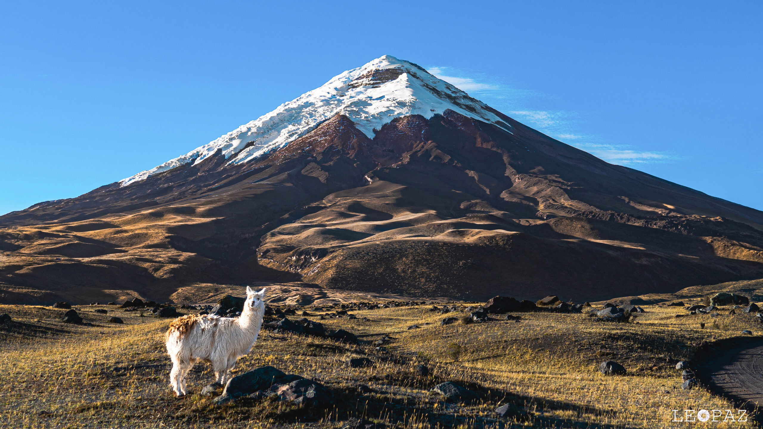
Cotopaxi is Ecuador’s second-highest peak at 5,897m / 19,347 ft — a massive, perfectly symmetrical glaciated stratovolcano that ranks among the world’s highest active volcanoes. The mountain entered a new eruptive phase on 21 October 2022 with ash emissions and seismic activity continuing through 2026, placing the mountain in elevated unrest status as you read this. Cotopaxi National Park welcomes 200,000+ annual visitors with the most accessible high-altitude experience in Ecuador — a $70-$120 day trip from Quito with Limpiopungo Lagoon, wildlife viewing, and an optional hike to the José Rivas Refuge at 4,864m. For climbers, the mountain offers the cheapest real glaciated summit in the world ($280-$590 for a 2-day program). Here’s everything you need to know for 2026.
Cotopaxi National Park. Parque Nacional Cotopaxi is one of Ecuador’s most important protected areas — established 11 August 1975 covering approximately 33,393 hectares (~334 km² / 129 mi²) of high-altitude páramo ecosystem surrounding the volcano. The park sits approximately 60 km south of Quito along the Pan-American Highway in the central Ecuadorian Andes, accessible as a 1.5-2 hour drive each way and one of the most popular day-trip destinations from the capital. Key park features include the Cotopaxi summit at 5,897m, the Limpiopungo Lagoon at 3,800m (a glacial wetland with reflective views of the volcano and major bird-watching site), the José Rivas Refuge at 4,864m (climbing base camp), the Pucara El Salitre Inca archaeological site, extensive páramo grasslands hosting wild horses, vicuñas, white-tailed deer, and Andean condors, and the park’s main visitor center and Interpretation Center. Park entrance fee: $10 for foreign visitors / $4 for Ecuadorian residents. Approximately 200,000 annual visitors. Park hours: 8:00 AM – 5:00 PM with last entry at 3:00 PM.
The History of Cotopaxi: Sacred Mountain, Active Volcano, Iconic Peak
Cotopaxi rises 5,897 meters (19,347 feet) above sea level in the central Ecuadorian Andes — making it the second-highest peak in Ecuador after Chimborazo, the highest peak in the Cotopaxi Province, and among the world’s highest active volcanoes. The mountain is a perfectly symmetrical stratovolcano (composite volcano), built up from alternating layers of andesitic lava flows and pyroclastic deposits over approximately 13,000 years of construction. The summit is capped by a 800m × 550m crater with inner crater walls displaying continuous fumarolic activity.
The volcano sits within the Eastern Cordillera (Cordillera Oriental) of the Ecuadorian Andes, with its base at approximately 3,800m and a total relief of approximately 2,100m above the surrounding páramo. The mountain is approximately 60 km south of Quito and 35 km northeast of Latacunga, making it among the most population-adjacent active major volcanoes in the world. The volcano’s symmetrical cone is visible on clear days from Quito, the Pan-American Highway, and as far as Riobamba (the staging town for Chimborazo expeditions, ~120 km south).
Find Hotels, Flights & Trips for the World’s Best Hiking Destinations
The Global Summit Guide Travel Shop on Expedia — curated for outdoor adventurers, mountaineers, and serious hikers. Patagonia to the Alps. Nepal to the Rockies. Curated lodging for every region we cover.
Explore Travel Shop on Expedia →Sacred Mountain in Indigenous Andean Tradition. Before Spanish conquest, the Indigenous peoples of the Ecuadorian highlands held Cotopaxi as one of the most sacred mountains in the central Andes — reverently called Cotopaxi in Quechua, with translations ranging from “neck of the moon” (cotto = neck, paxi = moon) to “shining mountain” depending on the source. Pre-Columbian Andean cultures, including the Panzaleo people (the dominant pre-Inca culture in the region) and later the Inca Empire (which expanded into Ecuador around 1463 under Tupac Inca Yupanqui), regarded Cotopaxi as the rain sender — the source of water flowing from the glaciers to the highland farms and the dwelling place of powerful mountain spirits (apus). The summit was considered sacred and was integrated into the broader Andean tradition of mountain spirit worship that remains active in Quechua communities today. The mountain played a central role in Inca cosmology of the northern empire, with various ceremonial sites established at the base. The Pucara El Salitre archaeological site within the modern park boundaries is a documented pre-Inca and Inca-era ceremonial and fortified structure that demonstrates the centuries of Indigenous presence on the mountain.
The Naming and the Avenue of the Volcanoes
The Spanish encountered Cotopaxi during the early 16th-century colonial expansion, but it was the German naturalist Alexander von Humboldt who placed the volcano in European scientific consciousness during his 1802 expedition through Ecuador. Humboldt — who also attempted Chimborazo during the same expedition — gave the broader region of paralleled Ecuadorian volcanoes the name “Avenue of the Volcanoes” (Avenida de los Volcanes) for the dramatic line of major volcanic cones flanking the Pan-American Highway between Quito and Riobamba. Cotopaxi is one of the most prominent peaks along this 120-mile stretch, joined by Cayambe (5,790m), Antisana (5,704m), Iliniza (5,248m), Tungurahua (5,023m), El Altar (5,319m), and Chimborazo (6,263m) — making the Avenue of the Volcanoes one of the most concentrated chains of major volcanoes on Earth.
1500s-1700s: Catastrophic Pre-Modern Eruptions
Cotopaxi was active throughout the pre-Columbian and Spanish colonial periods. Documented eruptions in 1532 (during the year of the Spanish conquest), 1742, 1744, 1766, and 1768 shaped the region’s settlement patterns and Indigenous-colonial relations. The 1744 eruption was particularly catastrophic, producing pyroclastic flows and lahars that destroyed substantial portions of the surrounding valleys and altered the demographic geography of central Ecuador. These early eruptions established Cotopaxi’s modern reputation as one of the most dangerous active volcanoes in the Americas — a reputation reinforced by the much larger 1877 eruption.
28 November 1872: First Recorded Ascent
The first verified summit of Cotopaxi was achieved on 28 November 1872 by German geologist Wilhelm Reiss and Colombian climber Ángel Escobar. The pair completed the climb during Reiss’s broader scientific expedition documenting Ecuadorian volcanoes (a separate expedition from Humboldt’s 1802 work). The ascent was a significant achievement — Cotopaxi was actively erupting during periods of the late 19th century, making summit attempts genuinely dangerous in a way that 21st-century climbers don’t always appreciate. The route the Reiss-Escobar party climbed is broadly similar to the modern standard north-side route used by virtually all 21st-century summit attempts.
26 June 1877: The Catastrophic Eruption
The 1877 eruption is the most significant volcanic event in modern Ecuadorian history. On 26 June 1877, Cotopaxi produced a major Plinian-style eruption — pyroclastic flows descended all sides of the volcano, melting substantial portions of the summit glacier and generating massive lahars (volcanic mudflows). The lahars traveled more than 100 km from the volcano, reaching both the Pacific Ocean (via the Pita and Esmeraldas river systems) and the western Amazon basin (via the Napo river system). Settlements along the lahar paths were devastated. Ashfall reached as far as Brazil. The 1877 eruption remains the benchmark scenario for modern lahar hazard planning around Cotopaxi, and the river valleys radiating from the volcano are still designated permanent danger zones with mandatory evacuation plans.
20th Century: Intermittent Activity
The 20th century saw Cotopaxi remain intermittently active, with documented eruptions in 1903-1904, 1906-1907, and 1942. The 1942 event was the last major eruption before the 21st-century reactivation phase. Between 1942 and 2015, the volcano remained in low-level unrest with periodic earthquakes and fumarolic activity but no surface eruptions. During this 73-year quiet period, Cotopaxi became increasingly accessible as a climbing destination — the modern José Rivas Refuge was constructed in 1972 and renovated multiple times since, the Cotopaxi National Park was established in 1975, and climbing infrastructure developed to support the growing international expedition market.
Cotopaxi Eruption: From 1877 to the Current 2022-2026 Activity
Cotopaxi is genuinely an active volcano in 2026 — not a quiet, dormant cone that “might erupt someday.” The mountain entered a new eruptive phase on 21 October 2022 and remained in elevated unrest through 2024-2026. Understanding the current activity is essential for anyone planning to visit Cotopaxi National Park or climb the volcano.
The 2022-2026 Eruption Phase (Current). Cotopaxi’s current eruption began on 21 October 2022 with a sudden increase in seismic activity and the onset of ash emissions from the summit crater. The Instituto Geofísico-Escuela Politécnica Nacional (IG-EPN) elevated the volcano alert status and aviation color code as ash plumes reached 200-2,500m above the crater with continued gas-and-steam emissions. By February 2023, the Geophysical Institute had documented approximately 8,000 earthquakes since the eruption onset — averaging 1,600 events per month. The eruptive activity continued through 2023 and into 2024-2026 with periodic phreatic explosions, ash emissions affecting communities including Latacunga and parts of southern Quito, and ongoing elevated seismicity. Current 2026 status: Low-level unrest with occasional phreatic activity, continued IG-EPN monitoring, and seasonal variations in activity. The volcano alert status changes periodically based on activity; visitors should always check the IG-EPN site (igepn.edu.ec) within 1-2 weeks of planned visits for current status. Park access and climbing permissions may be restricted during heightened activity windows — multiple closures occurred during 2022-2023 peak activity periods.
14 August 2015: The Modern Reawakening
Before the 2022 eruption, Cotopaxi’s most significant 21st-century activity began on 14 August 2015 when the volcano produced phreatic explosions and ash emissions after a 73-year quiet period. The 2015-2016 eruption phase produced ash columns reaching 50,000 ft / 15,240m altitude — well into commercial aviation routes — and triggered evacuation preparations for over 300,000 people living in lahar-vulnerable river valleys. The Ecuadorian government implemented a national emergency response with park closures, climbing prohibitions, and community evacuations in high-risk zones. The 2015 activity was relatively modest by Cotopaxi’s historical standards (substantially smaller than the 1877 catastrophe) but demonstrated the volcano’s ongoing capacity for major explosive activity. The eruptive phase formally ended in January 2016 with the volcano returning to background activity, though monitoring continued throughout 2016-2022 leading up to the 2022 reactivation.
The Lahar Hazard — The Real Cotopaxi Threat
Cotopaxi’s primary hazard to people is not lava flows or ashfall — it is lahars (volcanic mudflows). When pyroclastic material from an eruption interacts with the summit glacier (which still covers approximately 14 km² of the upper mountain), rapid melting generates massive flows of volcanic debris, water, and mud that channel down the river valleys radiating from the summit. Cotopaxi’s lahar hazard is among the most severe of any volcano on Earth, due to the combination of: (1) substantial summit glacier providing meltwater; (2) steep volcanic slopes accelerating flows; (3) deep river valleys focusing flows into vulnerable settlement areas; (4) substantial population (300,000+) living in lahar-vulnerable zones; and (5) major infrastructure including the Pan-American Highway and Quito’s airport crossing potential lahar paths.
The 1877 lahars reached 100+ km from the volcano, traveling all the way to the Pacific Ocean via the Pita and Esmeraldas rivers and to the Amazon basin via the Napo river. Modern lahar hazard maps designate permanent danger zones along these historic flow paths, with evacuation plans updated periodically by the Secretaría Nacional de Gestión de Riesgos. Tourist visitors to Cotopaxi National Park are not in lahar danger during day trips (the park infrastructure is positioned outside lahar paths), but the broader region’s lahar planning is a critical context for understanding Cotopaxi’s actual hazard profile.
Is Cotopaxi the Highest Active Volcano in the World?
The “highest active volcano in the world” claim is one of Cotopaxi’s most repeated facts — and one of its most misunderstood. The honest answer requires distinguishing what people typically mean from what is technically true.
The contested claim, explained. Cotopaxi at 5,897m is often described as “the highest active volcano in the world” in tourism marketing, travel guides, and even some climbing literature. This is not technically correct. The actual highest active volcano in the world by standard scientific measurement is Ojos del Salado on the Chile-Argentina border at 6,893m (22,615 ft) — nearly 1,000m taller than Cotopaxi. Other higher active or potentially-active volcanoes include Llullaillaco (6,739m, Chile-Argentina), Tipas (6,660m, Argentina), Pissis (6,795m, Argentina), and Tres Cruces (6,748m, Chile-Argentina). All of these are in the Puna de Atacama region of the southern Andes and exceed Cotopaxi’s elevation.
Where the “highest active volcano” claim comes from. The confusion has multiple sources: (1) Cotopaxi has substantially more frequent and well-documented historical activity than the Atacama volcanoes — 87+ documented eruptions vs Ojos del Salado’s minimal historical activity, leading some sources to discount the Atacama peaks as “active”; (2) some older sources used different elevation rankings before modern GPS surveys established the Atacama peaks’ true heights; (3) tourism marketing has commercial reasons to use the simpler, more impressive-sounding claim. The honest framing: Cotopaxi is “among the world’s highest active volcanoes” — typically ranked between 5th and 30th depending on the criteria used. By the strictest “frequently erupting + clearly classified as active” criteria, Cotopaxi is often considered the highest frequently erupting active volcano. But the literal “highest active volcano” title belongs to Ojos del Salado. Cotopaxi’s actual claim — one of the world’s most prominent active stratovolcanoes, with extraordinary historical eruptive frequency — is impressive enough without overstating it.
The honest list — world’s highest volcanoes with documented activity: (1) Ojos del Salado (6,893m, Chile-Argentina) — minor fumarolic activity, last eruption disputed but possibly ~750 CE; (2) Pissis (6,795m, Argentina) — historically active, currently quiet; (3) Llullaillaco (6,739m, Chile-Argentina) — last eruption 1877; (4) Tres Cruces (6,748m, Chile-Argentina) — historic activity; (5) Cotopaxi (5,897m, Ecuador) — actively erupting 2022-2026, 87+ historical eruptions, most documented and frequent activity of any high-altitude volcano. The “active” distinction matters — Cotopaxi is unambiguously, currently active in 2026 while several taller Andean volcanoes are classified as “potentially active” or “dormant” with limited documented eruptive history.
Cotopaxi vs Chimborazo: Which Ecuadorian Volcano to Climb
For international climbers planning Ecuador trips, the Cotopaxi vs Chimborazo question is the central decision point. The two peaks are Ecuador’s most iconic mountains, sit 120 km apart along the Avenue of the Volcanoes, and represent fundamentally different climbing experiences despite sharing the same broad Andean volcanic context.
The full Cotopaxi vs Chimborazo comparison.
| Dimension | Cotopaxi | Chimborazo |
|---|---|---|
| Elevation | 5,897 m (19,347 ft) | 6,263 m (20,549 ft) — +366 m |
| Volcanic status | Active — erupting 2022-2026 | Dormant — last erupted ~550 CE |
| Geographic distinction | Among world’s highest active volcanoes | Farthest point from Earth’s center; closest to sun |
| Standard climb duration | 2 days from Quito | 5-10 days with full acclimatization |
| Cost (guided) | $280-$590 per person | $2,500-$5,000 per person |
| Technical grade | PD- (basic glacier; Yanasacha section) | PD/AD- (more sustained glacier travel) |
| Standard route | North side · José Rivas Refuge | Whymper-Veintimilla SW side |
| Base camp elevation | 4,864 m (José Rivas) | 4,800 m (Hermanos Carrel) |
| Summit-day vertical gain | ~1,030 m | ~1,300-1,500 m |
| Annual summit attempts | ~3,000-4,000 | ~500-1,000 |
| Success rate | ~50-60% | ~40-60% |
| First ascent | 28 Nov 1872 (Reiss + Escobar) | 4 Jan 1880 (Whymper + Carrel brothers) |
| Day-trip option | Yes — major tourist destination | Less common; possible but distant |
| Park infrastructure | Major NP with 200K+ visitors/yr | Wildlife Production Reserve, lower traffic |
| Best for | First glaciated peak; quick Ecuador trip; active-volcano experience | First 6,000m+ peak; geographic curiosity; major mountaineering achievement |
The honest take: Cotopaxi is the easier, faster, cheaper, more accessible Ecuadorian volcano — the ideal first glaciated 5,000m+ summit and a meaningful achievement in a 4-5 day Ecuador trip. Chimborazo is the harder, longer, more expensive, more committing mountain — a real 6,000m+ mountaineering achievement with geographic distinction. Most international climbers planning Ecuador trips for the first time should consider Cotopaxi as the standalone goal or as the acclimatization peak before Chimborazo. The natural progression: visit Cotopaxi National Park on day 1-2 (acclimatization at Limpiopungo, hike to José Rivas Refuge), climb Cotopaxi on days 3-4, then either return home or continue to Chimborazo for days 5-10 with rest and additional acclimatization at Riobamba. Both peaks together form one of the world’s classic mountaineering destinations.
Why Cotopaxi Is the World’s Most Climbed Major Active Volcano
Cotopaxi occupies a position in global mountaineering that no other peak quite matches. Few mountains combine accessibility, elevation, active volcanic status, and dramatic aesthetic appeal at Cotopaxi’s level — making it simultaneously a major climbing destination, a major tourist destination, and a continuously-monitored geological hazard. The mountain’s role in Ecuadorian tourism and climbing economies is genuinely outsized: a single mountain that supports thousands of jobs across guides, refuge operators, tour companies, transport providers, gear rentals, and the broader Quito-Latacunga tourism corridor.
What makes Cotopaxi structurally distinct:
- The most climbed major glaciated peak in South America. Approximately 3,000-4,000 annual summit attempts make Cotopaxi the most-climbed major glaciated mountain in South America by a wide margin (Aconcagua sees ~5,000-7,000 attempts but on a non-glaciated trekking route to 6,961m, structurally different from Cotopaxi’s PD- glacier climb).
- The cheapest real glaciated summit in the world. $280-$590 for a 2-day guided program including all technical gear, refuge accommodation, transport from Quito, and meals. No comparable glaciated 5,500m+ summit anywhere on Earth approaches this price point — Mexican volcanoes (Pico de Orizaba, Iztaccíhuatl) run $1,500-$3,000+, North American glaciated peaks $1,500-$4,000+, Andean peaks $4,000+, Himalayan or African peaks $4,000+.
- Genuine active volcano experience. Cotopaxi is unambiguously erupting in 2026 — not “dormant” or “potentially active” but actively producing ash emissions and seismic activity. Climbers and park visitors experience a working volcano with continuous fumaroles, sulfur odor near the crater rim, and monitored seismic activity. Few accessible peaks offer this level of geological immediacy.
- Day-trip accessibility from a major capital. 60 km / 1.5-2 hour drive from Quito makes Cotopaxi the world’s most accessible major active volcano from a major international airport. Visitors arriving on an international flight can be at Limpiopungo Lagoon by lunch time the same day — a structural advantage no other major volcano matches.
- Avenue of the Volcanoes context. Cotopaxi is one of the most prominent peaks along the 120-mile Avenue of the Volcanoes — Alexander von Humboldt’s 1802 designation for the Pan-American Highway corridor flanked by eight major volcanic cones. This geography supports integrated multi-peak programs (Cotopaxi acclimatization for Chimborazo, Cotopaxi + Quilotoa day combos, full Avenue of the Volcanoes climbing tours).
- Major tourism volume supporting climbing infrastructure. 200,000+ annual park visitors create the economic base that sustains professional guide services, refuge operations, gear rental, transport networks, and the broader climbing economy. The result is one of the most well-developed mountain access infrastructures on any continent — climbers benefit from the tourism scale.
- Excellent acclimatization peak for Aconcagua, Denali, or Chimborazo. Cotopaxi’s combination of 5,897m elevation, real glaciated terrain, and short-trip format makes it the standard acclimatization climb for international mountaineers preparing for harder objectives. The mountain teaches glacier travel basics, altitude management, and roped-team protocols in a single 2-day program.
Where Cotopaxi fits in mountaineering progression: Cotopaxi is the natural first real glaciated summit for international climbers — accessible logistics, affordable budget, manageable technical demands, and substantive 5,897m altitude exposure. The mountain teaches crampons-and-axe technique, glacier rope team protocols, midnight-departure summit timing, and altitude management in a structured 2-day format that translates directly to harder objectives. As standalone goal, Cotopaxi is a meaningful glaciated summit and a real mountaineering achievement. As preparation for Chimborazo, Cotopaxi is the standard acclimatization peak. As preparation for Aconcagua, Denali, or Mexican volcanoes, Cotopaxi’s glaciated terrain and altitude exposure transfer directly. As part of a broader Ecuador volcano circuit, Cotopaxi is the centerpiece. As “just a fun hike” — no. Approach Cotopaxi with respect for what 5,897m of altitude, real glacier travel, and active volcanic hazards actually require.
Cotopaxi Historical Timeline
Following a major collapse event approximately 5,000+ years prior, the modern Cotopaxi stratovolcano begins building its current symmetrical cone through alternating layers of andesitic lava flows and pyroclastic deposits. The volcano takes its current form over the next 13,000 years through frequent eruptions.
Pre-Columbian Indigenous peoples — the Panzaleo and earlier cultures — establish Cotopaxi as a sacred mountain in the central Ecuadorian Andes. The mountain is regarded as the rain sender and integrated into Andean apu (mountain spirit) tradition. Ceremonial sites at the Pucara El Salitre area date from this period.
The Inca Empire under Tupac Inca Yupanqui expands into what is now Ecuador, integrating Cotopaxi into Inca cosmology and sacred geography. The volcano remains a central feature of Andean spirituality through the Inca period and into Spanish colonial times.
Cotopaxi erupts during the year of the Spanish conquest of the Inca Empire. The event is documented in early Spanish colonial records and contributes to the volcano’s reputation in 16th-century European geographic literature as one of the most active and dangerous volcanoes in the New World.
Series of significant eruptions in 1742, 1744, 1766, and 1768 — the 1744 event being particularly catastrophic with pyroclastic flows and lahars that destroyed portions of surrounding valleys. These eruptions establish Cotopaxi’s modern reputation as one of the most dangerous active volcanoes in the Americas.
German naturalist Alexander von Humboldt visits Ecuador as part of his American expedition. Names the Pan-American Highway corridor between Quito and Riobamba the “Avenue of the Volcanoes” (Avenida de los Volcanes) for the dramatic line of major volcanic cones. Cotopaxi is documented in Humboldt’s scientific writings as one of the most prominent peaks of the avenue.
German geologist Wilhelm Reiss and Colombian climber Ángel Escobar make the first verified summit of Cotopaxi via the north-side route — broadly the same line used by modern climbers. The ascent is significant given that Cotopaxi was periodically active during the late 19th century, making summit attempts genuinely dangerous.
Cotopaxi produces a major Plinian-style eruption — pyroclastic flows descend all sides of the volcano, melting summit glacier and generating massive lahars that travel 100+ km to the Pacific Ocean and the Amazon basin. Substantial settlement destruction. This event remains the benchmark scenario for modern lahar hazard planning around the volcano.
Cotopaxi remains intermittently active through the early-mid 20th century with documented eruptions in 1903-1904, 1906-1907, and 1942. The 1942 eruption marks the last significant activity before the modern reactivation phases of 2015 and 2022.
Parque Nacional Cotopaxi is formally established by the Ecuadorian government to protect 33,393 hectares of high-altitude páramo ecosystem and the volcano itself. The park becomes one of Ecuador’s most important protected areas and a major tourist destination. Climbing infrastructure including the José Rivas Refuge is developed under park management.
Cotopaxi produces phreatic explosions and ash emissions after a 73-year quiet period. Ash columns reach 50,000 ft / 15,240m altitude. Evacuation preparations for 300,000+ people in lahar-vulnerable river valleys. Park closures and climbing prohibitions implemented. The 2015-2016 eruption phase formally ends in January 2016 with the volcano returning to background activity.
Cotopaxi resumes significant volcanic activity after 6 years of quiet. Ash emissions reach 200-2,500m above the crater with continued seismic activity. IG-EPN elevates volcano alert status and aviation color code. The 2022 reactivation begins the current ongoing eruptive phase that continues through 2026.
IG-EPN reports approximately 8,000 earthquakes recorded at Cotopaxi since the October 2022 eruption onset — averaging 1,600 events per month. Continued ash emissions affect communities including Latacunga and parts of southern Quito. Park access restricted during periods of heightened activity.
Cotopaxi remains in elevated unrest with periodic phreatic activity, ongoing seismicity, continued gas emissions, and intermittent ashfall events. Park access varies based on activity level. IG-EPN continues continuous monitoring. The current eruption phase represents the longest sustained activity at Cotopaxi since the 1877 event.
How to Climb Cotopaxi: The Standard North-Side Route
Cotopaxi is climbed almost exclusively via the standard north-side route from the José Rivas Refuge — the broadly same line first climbed by Reiss and Escobar in 1872 and used by virtually all modern summit attempts. Other routes exist (the Yanasacha rock wall direct, the eastern face) but are rarely climbed due to objective hazards (crevasses, seracs) that make them substantially more dangerous than the standard route. The standard route is the focus of all commercial guiding programs.
| Route | Style | Distance / Vertical | Days | Status |
|---|---|---|---|---|
| North-Side Standard Route | PD- glacier; crampons + axe; roped | ~10 km RT / 1,030m gain from refuge | 2 days from Quito | ● Open · Standard · ~99% of summits |
| Yanasacha Direct (Variant) | Technical glacier; advanced | Similar; bypasses traditional traverse | 2-3 days | ● Experienced Climbers Only |
| Eastern Face | Technical alpine; expert | Variable | 3-4 days | ● Rarely Climbed · Seracs and crevasses |
| Day Trip Visit (Non-climbing) | Hiking to José Rivas Refuge | ~2 km hike from parking | 1 day | ● Open · Major tourist option |
The Standard 2-Day Cotopaxi Climb
Style: PD- glacier climb · Crampons, ice axe, rope team protocols · Used by 99% of summit attempts.
Day 1 — Quito to José Rivas Refuge:
- Morning departure from Quito (7:00-9:00 AM): Drive south on the Pan-American Highway approximately 60 km to the Cotopaxi National Park entrance. ~1.5-2 hour drive depending on traffic.
- Park entrance and acclimatization stop: Pay park entrance fee ($10 foreign / $4 Ecuadorian). Brief stop at the Limpiopungo Lagoon (3,800m) for photos and acclimatization. Visit the Interpretation Center for orientation.
- Drive to parking area (4,500-4,800m): Continue up the dirt road to the Cotopaxi parking area at approximately 4,500m. The road may be closed at lower elevations during volcanic activity periods.
- Hike to José Rivas Refuge (4,864m): Approximately 45-60 minutes of steep hiking from the parking area to the refuge. Substantial altitude gain — most climbers feel meaningful breathing effort. The refuge sits on a rocky shoulder of the volcano with dramatic views down to Limpiopungo and across to neighboring peaks.
- Afternoon rest, gear check, evening meal: Light afternoon activities at the refuge. Gear check with guides. Standard dinner around 6-7 PM. Attempt sleep starting around 8-9 PM — most climbers struggle to sleep due to altitude, anticipation, and the early start.
Day 2 — Summit Push and Descent:
- 11 PM-midnight departure: Wake up, light breakfast, gear assembly, depart from refuge by headlamp.
- 4,864 m → 5,100 m (1.5-2 hours): Initial section through volcanic scree and rocky terrain. Crampons typically donned at approximately 5,000m where the snow begins.
- 5,100 m → 5,500 m (2-3 hours): Main glacier section with steady climbing on moderate slopes (30-35 degrees). Crevasse navigation with roped teams. The first major altitude effects typically appear in this section.
- Yanasacha Rock Wall (5,500-5,700m): The crux of the standard route. A 200m+ rock wall section that the route traverses with steeper glacier climbing alongside. Some parties find this the technically hardest part of the climb; it requires confident roped travel and basic crampon technique.
- 5,700 m → 5,897 m (1-2 hours): Final summit dome and approach to the crater rim. Steeper terrain (40+ degrees) with the summit visible during the approach.
- Summit (5,897 m): The 800m × 550m crater is visible from the rim. Strong sulfur smell from continued fumarolic activity. Summit photos and brief rest. Standard summit times are between 6:00-7:30 AM.
- Descent (3-4 hours): Reverse the route back to the refuge. Most parties are back at the refuge by 10-11 AM.
- Return to Quito: Pack out from the refuge, descend to the parking area, drive back to Quito. Standard arrival back in Quito is mid-afternoon (3-5 PM) on Day 2.
Critical timing: The midnight start is non-negotiable. By 8-9 AM, sun on the upper glacier softens the snow and creates avalanche conditions on the steeper summit sections. Climbers who fall behind schedule must turn around rather than push past safe time limits.
Cotopaxi National Park Day Trip (Non-Climbing)
Style: Tourist day trip from Quito · No climbing equipment needed · Most popular Cotopaxi experience.
The vast majority of Cotopaxi National Park visitors come for the day-trip experience rather than the summit climb — approximately 200,000 annual park visitors with only 3,000-4,000 attempting the summit. The standard day-trip package is one of Ecuador’s most popular tourist activities.
Standard 8-10 hour day trip from Quito:
- 6:00-7:00 AM: Hotel pickup in Quito by tour operator van. Most major Quito hotels are on the pickup route; smaller hostels typically meet at a designated location.
- 7:00-9:00 AM: Drive south on the Pan-American Highway through the Avenue of the Volcanoes. Brief stop in Machachi for snacks and bathroom break.
- 9:00-9:30 AM: Arrive at Cotopaxi National Park entrance. Pay park entrance fee (typically included in tour package). Brief stop at the Interpretation Center for park orientation, geology, and wildlife information.
- 9:30-11:00 AM: Visit the Limpiopungo Lagoon at 3,800m — the iconic photography location with Cotopaxi reflected in the water. Walk around the lagoon (~30-45 minute loop), spot Andean wildlife (wild horses are the most reliable sighting), and learn about the páramo ecosystem.
- 11:00 AM-12:30 PM: Drive up to the Cotopaxi parking area at ~4,500m. Visitors should be acclimatized from the Limpiopungo stop. Substantial views of the upper mountain from the parking area.
- 12:30-2:30 PM: Optional hike to the José Rivas Refuge at 4,864m. Approximately 45 minutes up, 30 minutes down. Substantial altitude experience — most first-time visitors find this challenging due to altitude. Hot drinks and snacks typically available at the refuge.
- 2:30-3:30 PM: Lunch at refuge or back at the parking area. Many tours include a hot meal at this point.
- 3:30-5:30 PM: Drive back to Quito with arrival between 5-6 PM.
Variations and add-ons: Combined Cotopaxi + Quilotoa Lagoon programs ($120-$180) extend the day with a visit to the colorful Quilotoa crater lake. Cotopaxi + downhill mountain biking ($90-$130) replaces the refuge hike with a guided bike descent from the upper park. Cotopaxi horseback riding tours ($135-$200) substitute equestrian exploration of the páramo for the refuge hike.
Tour pricing: $70-$120 per person for standard group tours. $200-$400 per person for private tours. Most tours include hotel pickup, transport, English-speaking guide, park entrance fee, lunch, and basic snacks.
Pre-Climb Acclimatization Strategy
Climbing Cotopaxi without proper acclimatization has approximately 30-40% success rate; with proper acclimatization, the success rate climbs to 60-70%. The mountain rewards climbers who invest 3-5 days in pre-Cotopaxi acclimatization before the 2-day summit climb.
Standard Ecuadorian acclimatization progression (5-7 days total):
- Day 1-2: Quito (2,850m) — Arrive in Quito, spend 2 nights at this elevation. Light activity only on the first day. Walking tours of the historic center provide natural mild exertion at altitude.
- Day 3: Pichincha (Rucu Pichincha, 4,696m) — Day hike to Pichincha above Quito via the TelefériQo cable car to 4,050m, then 2-3 hour hike to summit. Returns to Quito for the night.
- Day 4: Pasochoa (4,200m) or Rumiñahui (4,712m) — Day hike to a 4,000m+ peak in the Quito vicinity. Pasochoa is the easier option; Rumiñahui (within Cotopaxi National Park) provides views toward Cotopaxi.
- Day 5: Iliniza Norte (5,126m) — Day climb to the non-technical summit of Iliniza Norte. Basic scrambling, no roped climbing required. The first 5,000m+ experience for most climbers.
- Day 6: Rest in Quito or transfer to Cotopaxi area — Final preparation day, gear check, brief.
- Day 7-8: Cotopaxi Climb — Day 1 to José Rivas Refuge, Day 2 summit attempt.
This 7-8 day program is the standard for international climbers without prior altitude experience. Climbers with recent altitude exposure (Kilimanjaro, Aconcagua, etc.) can compress this to 4-5 days. Climbers attempting Cotopaxi directly within 24-48 hours of sea-level arrival should expect substantially lower summit success rates and significantly worse altitude effects.
Other Cotopaxi National Park Activities
Cotopaxi National Park offers substantial activities beyond the summit climb and standard day trip. These options are particularly valuable for groups with mixed fitness levels or for visitors wanting deeper park experience.
- Downhill Mountain Biking ($90-$130): Vehicle transfer to the upper park (~4,500m), then guided bike descent through the páramo and out the park entrance. Approximately 30-40 km of mostly downhill biking. Popular activity that doesn’t require fitness for uphill climbing.
- Horseback Riding ($135-$200): Half-day or full-day horseback exploration of the páramo with views of Cotopaxi and the surrounding peaks. The horses are well-adapted to the high-altitude terrain. Particularly popular with travelers who want a unique perspective on the park.
- Limpiopungo Lagoon Loop (free with park entrance): 45-minute walking loop around the high-altitude lake at 3,800m. The most accessible activity in the park — most tours include this. Best photography location for Cotopaxi reflected in water.
- Pucara El Salitre Archaeological Site: Pre-Inca and Inca-era fortified ceremonial site at the lower park. Brief stop on most tour itineraries with park interpretation about Indigenous history.
- Rumiñahui Volcano (4,712m): Extinct volcanic peak in the southwestern park area. Day-hike accessible (5-7 hours round-trip) with views of Cotopaxi. Popular for climbers acclimatizing for Cotopaxi.
- Combined Cotopaxi + Quilotoa ($120-$180): Full-day tour combining Cotopaxi National Park visit with Quilotoa Lagoon (a colorful crater lake ~3 hours south). Substantial driving but covers two of Ecuador’s most photogenic locations.
- Cotopaxi Camping (varies by season): Park camping available in designated areas. Substantially weather-dependent and altitude-dependent. Mostly used by climbers as pre-climb acclimatization rather than recreational camping.
- Avenue of the Volcanoes Multi-Day Tours ($300-$800): 3-5 day programs visiting Cotopaxi, Quilotoa, Baños de Agua Santa, Riobamba, and (for climbers) Chimborazo. The premium Ecuadorian highland experience.
The Cotopaxi Elevation Progression (Quito to Summit)
The standard Cotopaxi climb progresses through these named locations from Quito’s 2,850m to the 5,897m summit — covering approximately 3,000m of total altitude gain typically over 2 days (or 5-7 days with full acclimatization):
Costs & 2026 Logistics
Cotopaxi is the cheapest real glaciated summit in global mountaineering. Standard 2-day climbing packages cost $280-$590 per person — substantially cheaper than any comparable glaciated peak elsewhere in the world. Tourism day-trip pricing is similarly affordable, making the broader Cotopaxi experience accessible to most international travelers.
| Item | Cost (USD) | Notes |
|---|---|---|
| Cotopaxi National Park entrance | $10/foreigner · $4/Ecuadorian | Per visitor; valid for one day; typically included in tour packages |
| José Rivas Refuge (independent) | $30-$50/night | Refuge accommodation only; bring own sleeping bag; meals separate; typically included in climbing packages |
| 2-Day Climbing Package (Group) | $280-$450/person | Standard group programs (4-8 climbers); includes guide, gear rental, transport from Quito, refuge, meals, park entrance |
| 2-Day Climbing Package (Premium/Private) | $500-$900/person | Smaller groups (1-3 climbers) or private guide; same inclusions plus higher-quality lodging |
| National Park Day Trip (Group) | $70-$120/person | 8-10 hour Quito-Cotopaxi-Quito tour; includes pickup, transport, guide, park entrance, lunch |
| National Park Day Trip (Private) | $200-$400/person | Private vehicle and guide; customized timing; resort/hotel pickup |
| Cotopaxi + Quilotoa Combo Day | $120-$180/person | Extended tour combining two locations; substantial driving but covers two iconic spots |
| Downhill Bike Tour | $90-$130/person | Vehicle to upper park + guided bike descent; popular alternative to refuge hike |
| Horseback Riding | $135-$200/person | Half or full day; well-adapted highland horses; unique perspective |
| Technical Gear Rental (boots, crampons, axe, harness) | $30-$60/day | Available in Quito; typically included in 2-day climbing packages; pieces approximately $10/day each |
| Travel Insurance (with altitude coverage) | $50-$100 | Standard policies don’t cover above 4,500m; Global Rescue, World Nomads Explorer Plus required |
| Flights to Quito (UIO) from US | $300-$700 round trip | Miami ($300-$500), JFK ($500-$700), LAX ($600-$800); 4-7 hour flights direct from major hubs |
| Flights to Quito from Europe | $700-$1,400 round trip | Typically routed via Madrid or Amsterdam; 12-14 hour total flight time |
| Quito hotel (mid-range, per night) | $40-$120 | Substantial range of options; La Mariscal and historic centro are standard tourist areas |
| Quito hotel (budget hostel) | $15-$35 | Hostels especially popular with backpacker climbers; dorm beds widely available |
| Standard 4-Day Cotopaxi Trip | $500-$1,000 per person | Flight + lodging + 2-day climb + meals; one of the cheapest mountaineering trips in the world |
| Cotopaxi-Only Day Trip Budget | $100-$200 per person | Tour + meals + Quito hotel; minimal commitment Ecuador add-on |
| Cotopaxi + Chimborazo Combo (10 days) | $3,500-$6,000 per person | Major mountaineering trip combining acclimatization peak (Cotopaxi) with 6,000m+ summit (Chimborazo) |
Cotopaxi is structurally the cheapest glaciated summit in global mountaineering. Direct cost comparisons for comparable glaciated 5,500m+ peaks: Pico de Orizaba combined with Iztaccíhuatl (Mexico) costs $1,500-$3,000 for 4-6 day programs at 5,636m. Aconcagua (Argentina) costs $4,000-$8,000 for an 18-21 day expedition at 6,961m. Denali (Alaska) costs $8,000-$12,000 for a 14-21 day expedition at 6,194m. Himalayan 5,500-6,000m peaks (Mera, Island Peak) cost $4,000-$8,000 for 18-21 day trips. Cotopaxi provides a genuine glaciated 5,897m summit at $280-$590 in a 2-day timeframe — structurally cheaper than any other major glaciated mountain on Earth by a wide margin. The reason: Ecuador’s well-developed tourism infrastructure, short flight access from North America, modest national costs, and the mountain’s proximity to Quito allow for ultra-efficient logistics that no other major mountain destination matches.
Best Time to Climb & Cotopaxi Weather Patterns
Cotopaxi’s near-equatorial latitude (0°41′ S) creates a distinct weather pattern from temperate-zone mountains. The volcano has no true “winter” or “summer” — instead two distinct dry seasons alternating with two wetter seasons. Daily temperature variation matters more than seasonal variation; the summit can be below freezing at sunrise regardless of month.
| Period | Window | Conditions | Watch For |
|---|---|---|---|
| Primary Climbing Season | December – February | Stable dry season; firmest snow; clearest summit views; highest success rates | Peak booking demand; reserve refuges 1-2 months in advance; December-January often optimal |
| Wet Transition | March – May | Increased precipitation; afternoon storms; substantially worse climbing conditions | Lower success rates (30-40%); soft snow on upper mountain; cancelled summit attempts common |
| Secondary Climbing Season | June – September | Second dry season; cooler temperatures; stronger winds; generally reliable conditions | July-August can bring strongest winds; otherwise solid climbing window |
| Late Wet Transition | October – November | Increasingly unstable; afternoon cloud and precipitation | Not recommended for first-time attempts; experienced climbers sometimes attempt with weather windows |
| Volcanic Activity Restrictions | Year-round (variable) | Park access may be restricted during heightened volcanic activity | 2022-ongoing eruption phase has caused multiple closure periods; verify IG-EPN status before booking |
The volcanic activity factor — unique to Cotopaxi. Unlike Chimborazo (dormant) or most other Andean peaks, Cotopaxi’s climbing access can be restricted based on volcanic activity status. The current 2022-ongoing eruption phase has caused multiple park closures and climbing prohibitions during periods of heightened activity. The Instituto Geofísico-Escuela Politécnica Nacional (IG-EPN) publishes daily activity reports and volcano alert status updates. Always verify current status at igepn.edu.ec within 1-2 weeks of your planned visit. Tour operators monitor this continuously and will cancel or modify programs based on activity levels. Climbing during active eruption phases is genuinely dangerous — pyroclastic flows and lahar generation can occur with limited warning.
Summit weather realities — substantially worse than the lower park. Cotopaxi’s summit weather is severe regardless of season. Average summit temperatures during summit-night/morning windows: -10°C to -20°C (14°F to -4°F), with substantial additional wind chill. Wind speeds at the summit regularly 30-60 km/h (20-40 mph); gusts to 80-100 km/h (50-60 mph) during weather events. UV exposure at 5,897m is extreme — among the most intense UV environments on Earth due to high altitude, equatorial latitude, and reflective glacier surface. Visibility can drop to under 10m in cloud or whiteout conditions. The mountain’s near-equatorial position means weather changes develop rapidly without multi-day forecast warning. Climbers must be prepared for sudden weather changes during the 6-8 hour summit climb. Guide operators monitor conditions closely and will abort summit attempts on short notice; clients should be prepared for late-night cancellations even after substantial trip investment.
Essential Gear Checklist
Cotopaxi requires real glaciated mountaineering equipment — substantially more than Andean trekking but less than expedition objectives. Guided operators provide all technical gear (crampons, ice axe, harness, helmet, rope) included in the 2-day package price; climbers bring their own personal clothing and basic items. Park day-trip visitors need only standard hiking clothing plus warm layers for the 4,800m elevation.
Climbing Cotopaxi (Provided by Guides)
- Mountaineering boots (rigid-soled, crampon-compatible) — La Sportiva Nepal Evo or equivalent
- Crampons (12-point steel; rigid binding)
- Ice axe (60-70 cm mountaineering length)
- Climbing helmet
- Climbing harness (alpine/glacier rated)
- 2-3 carabiners + slings
- 50-60m glacier travel rope
- Prussik cords
- Belay device
- Note: All of the above typically included in $280-$590 package price; verify with operator
Personal Clothing System (Climbers Bring)
- Base layers (synthetic or merino — top and bottom)
- Lightweight insulating mid-layer (fleece)
- Heavy insulating layer (down jacket, 600+ fill)
- Hardshell jacket (waterproof and breathable)
- Hardshell pants (waterproof, full-side zip preferred)
- Insulated mountaineering gloves + glove liners
- Mittens for summit (extreme cold backup)
- Warm hat + sun hat
- Buff or neck gaiter
- Glacier sunglasses (Category 4 — UV is extreme)
- Insulated mountaineering socks (2-3 pairs)
- Liner socks (blister prevention)
- Trekking poles (for approach to refuge)
Park Day-Trip Visitors
- Sturdy hiking shoes or boots (not sandals)
- Long pants (sun + wind protection)
- Layered upper body: base + fleece + windshell
- Light rain jacket
- Warm hat or beanie
- Sunglasses
- Sunscreen SPF 50+ (UV extreme at altitude)
- Lip balm with SPF
- Water (1-1.5 liters minimum)
- Light snacks
- Camera with appropriate batteries
- Light gloves (helpful if hiking to refuge)
High-Altitude Health Items
- Personal prescription medications + extras
- Diamox (acetazolamide) if prescribed by physician — common for altitude
- Ibuprofen and aspirin for altitude headache
- Electrolyte tablets / drink mix
- High-altitude energy food (gels, bars, chocolate)
- Hand warmers / chemical heat packs (cold drains fast at altitude)
- Headlamp with substantial spare batteries (cold drains fast)
- Travel insurance with altitude/evacuation coverage
- IG-EPN site bookmarked for current volcanic status checks
Difficulty & What Cotopaxi Actually Demands
Cotopaxi is misleadingly often described as “a beginner glaciated peak” — and while it’s genuinely accessible compared to harder objectives, that framing creates dangerous misconceptions. The mountain has caused multiple fatalities over the decades and demands real respect for what 5,897m of altitude, glaciated terrain, and active-volcano hazards actually mean. Five specific characteristics define what the mountain actually requires:
1. The altitude is real — 5,897m is not “almost 6,000m,” it IS 6,000m for practical purposes. At 5,897m, Cotopaxi sits within the altitude range where AMS is universal in unacclimatized climbers and where life-threatening HAPE or HACE are real risks. Climbers attempting Cotopaxi directly from sea level (within 24-48 hours of arrival in Quito) have summit success rates under 30% and significantly elevated medical evacuation risk. Even with proper acclimatization, expect substantial AMS symptoms during the summit climb. The 2-day package format doesn’t include enough acclimatization for direct-from-sea-level climbers — invest 3-5 additional days at Quito and 4,000m+ peaks before attempting Cotopaxi.
2. The Yanasacha crux is harder than it looks in photographs. The Yanasacha rock wall section between 5,500-5,700m is the technical crux of the standard route. Photographs make this look like routine glacier climbing; in person, the steeper sections (40+ degrees), exposed rock features, and altitude effects combine to create genuine difficulty for first-time glaciated-peak climbers. Climbers must be comfortable with sustained front-pointing on crampons, confident roped travel with potential fall consequences, and quick decision-making about route conditions. This is where the majority of failed Cotopaxi attempts turn around — not from lack of fitness but from realizing the terrain is harder than expected.
3. The active volcano hazard is real. Cotopaxi is not “dormant” — it is genuinely, currently erupting in 2026. The current 2022-ongoing eruption phase has caused multiple park closures and climbing prohibitions during heightened activity windows. Pyroclastic flows, lahar generation, and ashfall events have occurred during the 2022-2024 period. The mountain can change status with limited warning. Verify IG-EPN current alert status within 1-2 weeks of departure and again 24-48 hours before summit attempt. Trust guide operators’ decisions to abort or postpone — they monitor activity continuously. Climbers who attempt summits during heightened activity periods are taking on substantially elevated risk that no insurance policy will cover.
4. The summit-day timing window is non-negotiable. Standard Cotopaxi summit attempts must depart José Rivas Refuge by midnight (11 PM common), summit between 6:00-7:30 AM, and be off the upper glacier by 8-9 AM at the latest. The reason: sun on the upper glacier above the Yanasacha section softens snow within 2-3 hours of full daylight, creating avalanche conditions on the steep summit dome. Climbers who fall behind schedule must turn around rather than push past safe time limits. The standard turnaround rule: “summit by 7:30 AM, or turn around regardless of how close.” Multiple climber rescues per year involve parties that pushed past safe turnaround times.
5. The lahar evacuation context — relevant for park visitors too. Cotopaxi’s primary hazard to people is not summit-climbing risks but lahar (volcanic mudflow) hazard for the broader region. Park visitors are not in lahar danger during day trips (park infrastructure is positioned outside historic lahar paths), but the 300,000+ people living in lahar-vulnerable river valleys around the volcano face genuine ongoing risk. Climbers and park visitors should understand the broader context: if the volcano enters a significant eruptive phase during your visit, evacuations of surrounding communities may be triggered, transport may be disrupted, and the overall regional situation may change rapidly. The Secretaría Nacional de Gestión de Riesgos maintains current evacuation plans; trust local authority guidance during any volcanic emergency.
What Cotopaxi rewards: Climbers with cardiovascular fitness for sustained altitude effort; 3-5 days of pre-Cotopaxi acclimatization on lower Ecuadorian peaks; basic glacier travel comfort from prior experience or pre-climb instruction; willingness to follow guide operator timing protocols strictly; flexibility about weather windows and willingness to abort if conditions deteriorate; awareness of current volcanic activity status; and “guided climb” framing rather than “scramble it solo” framing. As standalone goal, Cotopaxi is a meaningful glaciated 5,897m summit and a real mountaineering achievement. As preparation for Chimborazo, Cotopaxi is the standard acclimatization peak — the natural progression is Cotopaxi (5,897m) → rest in Riobamba → Chimborazo (6,263m). As preparation for Aconcagua, Denali, or Mexican volcanoes, Cotopaxi’s glaciated terrain and altitude exposure transfer directly. As “a beginner peak” — Cotopaxi is accessible to fit motivated climbers with proper preparation, but it’s not casual. Approach Cotopaxi with respect for what 5,897m, active volcanism, and real glaciated terrain actually demand.
Featured Cotopaxi Operators & Resources
The Cotopaxi guided market is one of the most developed in global mountaineering — dozens of reputable operators in Quito and Latacunga offer Cotopaxi programs ranging from budget group climbs to premium IFMGA-guided expeditions. The volume of operations (3,000-4,000 annual summit attempts) supports a competitive market with reasonable pricing. Below are the established operators in 2026.
Ecuador Eco Adventures
Quito-based operator with substantial Cotopaxi specialization and Chimborazo programs. Strong reputation for client experience and cultural context. Local Ecuadorian guide team. Combined Cotopaxi-Chimborazo programs commonly booked together. ecuadorecoadventures.com
Andean Summit Adventures
Quito-based operator specializing in Ecuadorian volcano climbing. Strong reputation for Cotopaxi 2-day programs at mid-range pricing ($350-$500). Local guide team with extensive Cotopaxi experience. Spanish and English language guiding.
Carpe DM (Quito)
Long-established Quito-based operator with broad Ecuadorian climbing and trekking offerings. Cotopaxi programs at budget-friendly pricing ($280-$400). Particularly popular with backpacker travelers staying at major Quito hostels (substantial referral relationships).
Tours Around Ecuador
Major Cotopaxi day-trip operator with hotel pickup throughout Quito. Multiple program tiers from $70 group tours through private $250+ programs. Combined Cotopaxi + Quilotoa packages popular. toursaroundecuador.com
Cotopaxi Tour (cotopaxitour.com)
Specialized Cotopaxi-focused operator with both day trips and 2-day climbing programs. Established Quito operations with substantial fleet for daily departures. Detailed pre-trip information and current activity reporting. cotopaxitour.com
Alpenglow Expeditions
International operator (US-based) offering premium Cotopaxi programs combined with Chimborazo. IFMGA-certified guides, smaller group ratios, extended acclimatization. Substantially higher pricing ($3,500-$6,000 for the combined 10-day program) but premium experience. alpenglowexpeditions.com
IG-EPN (Instituto Geofísico)
The Instituto Geofísico-Escuela Politécnica Nacional is Ecuador’s national volcano monitoring agency and the authoritative source for current Cotopaxi activity status. Publishes daily activity reports, volcano alert levels, and aviation color codes. Essential pre-trip resource for all Cotopaxi climbers and visitors. igepn.edu.ec
Cotopaxi National Park Office
The Ecuadorian Ministry of Environment manages Cotopaxi National Park. Park status, entrance hours, and access restrictions are published through the ministry’s tourism portal. Direct booking for José Rivas Refuge accommodation (when not part of guided package) is available through the park office.
Frequently Asked Questions
Cotopaxi National Park (Parque Nacional Cotopaxi) is a major Ecuadorian protected area established 11 August 1975 covering approximately 33,393 hectares of high-altitude páramo ecosystem surrounding the Cotopaxi volcano. The park sits roughly 60 km south of Quito along the Pan-American Highway, accessible as a day trip from Quito (1.5-2 hour drive each way). Key features include the Cotopaxi summit at 5,897m, the Limpiopungo Lagoon at 3,800m (a high-altitude wetland that is the iconic photography location), the José Rivas Refuge at 4,864m (the climbing base camp), the Pucara El Salitre Inca archaeological site, extensive páramo grasslands hosting Andean wildlife (wild horses, vicuñas, white-tailed deer, Andean condors), and the Interpretation Center. Park entrance fee is $10 for foreign visitors / $4 for Ecuadorian residents. The park hosts approximately 200,000 visitors annually.
Cotopaxi is climbed via the standard north-side route — a non-technical glacier climb that begins at the José Rivas Refuge at 4,864m. Most climbers complete the ascent as a 2-day program: Day 1 involves driving from Quito to the Cotopaxi parking area at ~4,500-4,800m, then hiking 45 minutes to the José Rivas Refuge. Day 2 begins with a midnight departure for the 6-8 hour summit climb. The route ascends through three sections: initial rocky/scree to ~5,100m, then the glacier proper with crampons and ice axe, then the famous Yanasacha rock wall section before the final summit dome and 800m-wide crater rim at 5,897m. The route is technically moderate (PD- grade). Success rates approximately 50-60% with proper acclimatization. The mountain requires Ecuadorian-licensed guides for all foreign climbers.
Cotopaxi is often described as the highest active volcano in the world, but this claim is contested. The actual highest active volcano by standard scientific measurement is Ojos del Salado on the Chile-Argentina border at 6,893m — substantially taller than Cotopaxi’s 5,897m. Other higher active or potentially-active volcanoes include Llullaillaco (6,739m), Tipas (6,660m), and Pissis (6,795m). However, Cotopaxi has stronger documented historical activity than these higher peaks — 87+ recorded historical eruptions vs minimal activity at the Atacama peaks. The honest framing: Cotopaxi is among the world’s highest active volcanoes (typically ranked 5th-30th depending on criteria) but is NOT the literal highest. The “highest active volcano” claim is impressive marketing but inaccurate. Cotopaxi’s actual claim — one of the world’s most prominent and frequently erupting active stratovolcanoes — is impressive enough without overstating it.
Cotopaxi’s most recent eruption began on 21 October 2022 and continued through at least mid-2023 with continued elevated activity into 2024-2026. The eruption consists of ash emissions reaching 200-2,500m above the crater, frequent earthquakes (1,600 events per month at peak), and constant gas-and-steam emissions. As of 2026, Cotopaxi remains at low-level unrest with occasional phreatic activity. The previous major eruptive phase was August 2015 – January 2016, which produced ash plumes to 50,000 ft and triggered evacuation preparations for 300,000+ people. The most catastrophic historical eruption was the 26 June 1877 event which produced pyroclastic flows down all sides and lahars that reached 100+ km into the Pacific Ocean and Amazon basin.
Cotopaxi (5,897m) and Chimborazo (6,263m) are Ecuador’s two iconic volcanoes. Cotopaxi is active (last erupted 2022, ongoing unrest); Chimborazo is dormant (last erupted ~550 CE). Cotopaxi is the more popular climb with 3,000-4,000 annual summit attempts vs Chimborazo’s 500-1,000. Cotopaxi can be climbed in a 2-day program ($280-$590) while Chimborazo requires a 5-10 day acclimatization itinerary ($2,500-$5,000). Cotopaxi’s route is technically simpler (PD-) but Chimborazo’s altitude is more demanding. The standard recommendation: climb Cotopaxi FIRST as an acclimatization peak before Chimborazo, or as a standalone for climbers who want a real glaciated 5,000m+ summit without the larger commitment. Chimborazo wins on geographic distinction (closest point to the sun, farthest from Earth’s center); Cotopaxi wins on accessibility, affordability, and the active-volcano experience.
Cotopaxi is moderately dangerous — substantially more accessible than Chimborazo or technical alpine peaks, but with real hazards. Primary hazards: (1) Altitude — at 5,897m, AMS is universal and HAPE/HACE risks are real; (2) Crevasse hazards — the glacier route has crevasses requiring roped team navigation; (3) Avalanche risk — particularly above the Yanasacha rock wall during warming conditions; (4) Volcanic hazard — the mountain is genuinely active; the 2022-ongoing eruption phase produces periodic ashfall and lahar risk; (5) Lahar hazard for park visitors — Cotopaxi’s primary hazard to people is not lava but lahars (volcanic mudflows). The 1877 lahars reached 100+ km from the volcano. Climbing fatalities approximately 1-2 per year. Always verify current volcano alert status with IG-EPN before climbing.
Cotopaxi is one of the most affordable major glaciated 5,000m+ summit experiences in global mountaineering. Standard 2026 pricing: 2-day guided summit climb costs $280-$590 per person depending on group size, operator, and inclusions. Group programs: $280-$400 per person. Private programs: $500-$900 per person. The package typically includes round-trip transport from Quito, José Rivas Refuge overnight, technical gear rental, guide services, meals during the climb, and park entrance. Additional costs: Quito pre-trip lodging ($30-$120/night), travel insurance with altitude coverage ($50-$100), tips. Total realistic 4-5 day Cotopaxi trip budget: $600-$1,200 per person including flights from major US cities ($300-$700 round trip).
Cotopaxi’s two main climbing seasons are December-February and June-September, with December-January often considered the optimal window. December-February brings the highland dry season with firmest snow conditions on the glacier, clearest summit views, and the highest summit success rates. June-September is the secondary dry season — slightly colder temperatures and stronger winds but generally reliable conditions. The shoulder seasons (March-May and October-November) are wetter with substantially worse glacier conditions. As an active volcano with the 2022-ongoing eruption phase, Cotopaxi access may be restricted during heightened volcanic activity — climbers should verify current park access status with IG-EPN and park authorities before booking. Daily timing: standard summit attempts depart between 11 PM and midnight with the goal of reaching the summit between 6-7 AM.
Yes — Cotopaxi National Park is one of Ecuador’s most-visited tourist destinations specifically because it offers extraordinary experiences without requiring summit climbing. Standard day-trip visits from Quito ($70-$120 per person) include: the Pan-American Highway drive south through the Avenue of the Volcanoes, park entrance and Interpretation Center orientation, Limpiopungo Lagoon visit at 3,800m, short hikes through the páramo to view Andean wildlife (wild horses, vicuñas, deer, occasionally Andean condors), and an optional hike up to the José Rivas Refuge at 4,864m. The full day-trip package typically runs 8-10 hours from Quito hotel pickup to return. Popular extensions: combined Cotopaxi + Quilotoa Lagoon programs ($120-$180), Cotopaxi + horseback riding ($135-$200), and downhill mountain biking ($90-$130).
Cotopaxi Map & Latacunga Weather
Cotopaxi summit coordinates: 0°40’50″S 78°26’16″W (-0.6806, -78.4378). The map below shows the volcano’s position in central Ecuador, approximately 60 km south of Quito and 35 km northeast of Latacunga. Live weather is shown for Latacunga — the closest major town and key reference point for Cotopaxi conditions. Summit conditions are typically 25-35°C colder than Latacunga due to the ~3,300m elevation difference.
Access & Logistics: Acclimatization Strategy & Refuge Guide
Was this helpful?
🏔Related peaks nearby
🧭Explore & compare
Global Summit Guide is an independent mountaineering resource founded in 2026. The team combines first-hand trekking and climbing experience with in-depth research and professional health and nutrition review to help climbers choose objectives, prepare properly, and stay safe.
Health, altitude, and nutrition content is reviewed by Taylor Ludlow (Registered Nurse) and Brigg Hoopes (Nutritionist).
What We Don't Know Yet
Mountain information changes quickly. This box explains the limits of what this page can responsibly promise.
- Permit availability, reservation windows, quotas, and official fee rules may change after this page is updated.
- Route conditions, trailhead access, crevasse exposure, stream crossings, and rescue access may vary from published planning guidance.
- Gear requirements can change by season, route variation, weather window, personal cold tolerance, and guide-service requirements.
- Fitness and altitude response vary by person; no guide, itinerary, or training plan can guarantee acclimatization or summit success.
- Comparisons simplify complex decisions; the better mountain depends on current conditions, skills, timing, budget, and risk tolerance.
Verify current conditions with official land managers, guide services, local forecasts, and current route reports before booking or climbing.
Part of this Global Summit Guide cluster
Explore the complete Mountains guide for more context, routes, planning links, and related resources.
Mountaineering, rock and ice climbing, glacier travel, and high-altitude activity are inherently dangerous and can result in serious injury or death. The information on Global Summit Guide is provided for general informational and educational purposes only and is not a substitute for professional instruction, qualified guiding, proper equipment, or your own judgment and experience.
Route conditions, weather, snowpack, permits, regulations, and hazards change constantly and may differ from what is described here. Details may be incomplete, out of date, or contain errors. Always verify current information with local authorities, certified guides, and official sources before making any decision in the mountains.
Nothing on this site is medical, legal, or financial advice. Our fitness, acclimatization, altitude, and nutrition content is general in nature; consult a qualified physician before beginning any strenuous exercise program or exposing yourself to high altitude.
You are solely responsible for your own safety and decisions. To the fullest extent permitted by law, Global Summit Guide and its team accept no liability for any loss, injury, damage, or expense arising from use of, or reliance on, this information. By using this site you acknowledge these risks and accept these terms.
Some links on this site may be affiliate links. If you buy through them we may earn a small commission at no extra cost to you; this never affects our recommendations.
Global Summit Guide recommendation path
Next Best Mountain to Research
Use these recommendations to continue the right planning path instead of stopping on one page.
Use current permit, weather, route, and operator information before booking or climbing.