
Last updated September 16, 2026
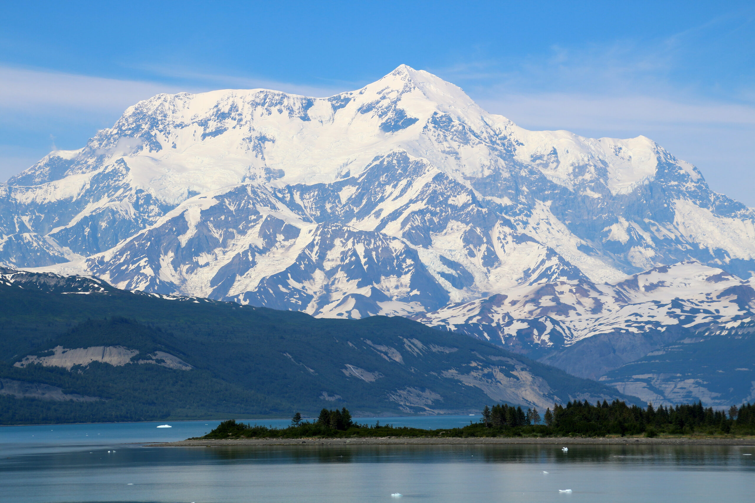
Climbing Mount Saint Elias: Routes, Logistics and Why It Is So Difficult
Mount Saint Elias is an 18,008-foot expedition peak on the Alaska-Yukon border with no easy route to its summit. This guide explains the major historical and modern lines, glacier access, park and border requirements, weather, cost planning and the experience needed for one of North America’s most committing mountains.
Mount Saint Elias is a remote technical expedition—not a higher version of Denali.
Elevation: 5,489 m / 18,008 ft. Location: directly on the Alaska-Yukon border. Defining difficulty: steep glaciated terrain combined with Pacific storm exposure, aircraft-dependent access and very limited rescue infrastructure.
Most teams need approximately two to four weeks, deep glacier and alpine experience, a self-sufficient expedition system and enough schedule flexibility to wait through extended storms or aircraft delays.
Mount Saint Elias essential facts
The mountain’s position, relief and jurisdiction explain much of its expedition complexity.
| Elevation | 5,489 m / 18,008 ft |
| Location | Alaska, United States / Yukon, Canada international border |
| Coordinates | 60.2933° N, 140.9311° W |
| Mountain range | Saint Elias Mountains |
| National ranking | Second-highest mountain in both the United States and Canada |
| United States jurisdiction | Wrangell-St. Elias National Park and Preserve |
| Canadian jurisdiction | Kluane National Park and Reserve |
| First ascent | 1897 Duke of the Abruzzi expedition |
| Second ascent | 1946 via the Southwest Ridge / South Ridge system |
| Established season | Generally mid-April through late June, subject to current conditions and park guidance |
| Primary access model | Aircraft-supported glacier expedition from Alaska or Yukon |
| Typical expedition model | Private, highly experienced and self-sufficient team |
Major Mount Saint Elias routes
Route names and exact variations differ between historical accounts. The table below avoids implying that any line is routine or consistently maintained.
| Route or line | Side | Historical importance | Character | Modern relevance |
|---|---|---|---|---|
| Southwest Ridge / South Ridge | Alaska | Used for the 1946 second ascent | Long glacier expedition with steep snow, ice and mixed terrain | Principal modern Alaska-side line in many expedition accounts |
| Abruzzi Ridge | Yukon / north | 1897 first-ascent route | Historic glacier and ridge expedition with major objective hazards | Rarely attempted |
| Northwest Ridge | Northwest | First climbed in 1965 | Steep ice, rock, cornices, avalanches and extensive fixed-rope climbing | Technical historical objective |
| South and Mira Face variations | Alaska / south | Modern technical projects | Steep mixed and face climbing with limited route repetition | Elite alpine teams only |
| Sea-to-summit ski projects | Icy Bay / south | Modern ski-mountaineering history | Nearly sea-level approach, technical climb and complex ski/down-climb descent | Specialized and exceptionally committing |
Southwest Ridge / South Ridge
Alaska side · 1946 second-ascent system · Principal modern expedition option
This route system is commonly treated as the practical starting point for modern Mount Saint Elias planning. Teams usually rely on aircraft-supported glacier access and establish multiple camps while waiting for a stable weather window. The exact landing zone, camp sequence and upper-line variation depend on glacier conditions, pilot judgment and the team’s objectives.
- Requires advanced crevasse-rescue and glacier-navigation systems.
- Combines expedition hauling with steep snow, ice and mixed terrain.
- Has no guaranteed fixed ropes, established camps or ranger infrastructure.
- Can involve extended storm holds on both ascent and descent.
- Must be researched through recent route reports rather than a fixed itinerary.
Abruzzi Ridge
Historic 1897 first-ascent line · Yukon side
The Duke of the Abruzzi expedition reached the summit by the northern route in 1897. Its place in climbing history is secure, but a historic first-ascent line should not automatically be treated as the safest or most practical modern option. Glacier change and objective hazards require current route-specific evaluation.
Northwest Ridge
First climbed in 1965 · Major technical expedition route
The American Alpine Journal account of the 1965 ascent describes steep rock and ice climbing, avalanche exposure, cornices, a 1,500-foot face and approximately 4,900 feet of fixed rope. It is a valuable primary source because it shows how much hardware, time and expedition organization were required even by a strong team.
Why Mount Saint Elias is so difficult
The mountain’s seriousness comes from the way terrain, climate, access and rescue limitations compound.
Pacific storm exposure
Moist coastal systems can produce rapid loading, prolonged snowfall, high winds and long periods without a safe summit or aircraft window.
No easy route
Every major line requires real expedition climbing. Historical accounts describe steep ice, mixed terrain, cornices, avalanche exposure and complex route finding.
Aircraft dependence
Glacier access and extraction depend on pilot judgment, landing conditions and weather. A scheduled pickup date is never guaranteed.
Large vertical relief
The mountain rises dramatically from the coastal side, creating long approaches and unusually large relief even though the summit is below Denali’s elevation.
Minimal infrastructure
There are no normal high camps, ranger stations, fixed route systems or routine commercial rescue resources on the mountain.
Retreat complexity
A storm, injury or route failure may leave a team days from a landing zone and unable to fly out until conditions improve.
Who should attempt Mount Saint Elias?
The relevant question is not whether a climber is fit, but whether the entire team can operate independently in a remote alpine system.
Minimum experience profile
- Major glacier expedition experience, commonly Denali or an equivalent objective
- Independent crevasse rescue and complex roped glacier travel
- Steep snow, ice and mixed climbing competence
- Multi-week cold-weather camp management
- Navigation in whiteout and poor visibility
- Avalanche assessment and storm decision-making
- Ability to repair systems and manage emergencies without nearby support
Reasons to choose another peak first
- This would be your first remote glacier expedition
- You depend on a guide for rope systems and rescue procedures
- Your return date cannot absorb prolonged weather delays
- Your team has not previously managed serious cold or multi-day storms
- You expect established camps, fixed ropes or reliable rescue access
- Your budget does not include substantial contingency funds
A practical progression is to build glacier and expedition competence on Mount Rainier, develop multi-week systems through the Denali climbing guide, and study comparable advanced objectives such as Mount Foraker before treating Saint Elias as realistic.
Access, authorization and border planning
Mount Saint Elias requires expedition-level administrative planning because the mountain crosses a national border and two protected areas.
| Expedition movement | Planning requirement |
|---|---|
| Alaska-side expedition | Confirm current requirements, landing plans and backcountry guidance with Wrangell-St. Elias National Park and the selected air service. |
| Entering Kluane National Park | Apply in advance and complete the mountaineering registration required by Parks Canada. |
| Entering Canada from Alaska on foot | Obtain prior Canadian border clearance before the expedition; a remote mountain crossing is still an international entry. |
| Glacier landing | Coordinate the exact landing zone, load plan, weather limits and pickup procedure directly with the pilot and relevant park. |
| International team members | Confirm United States and Canadian entry, visa and document requirements before staging. |
| Emergency planning | Carry redundant satellite communication, written contacts, insurance documents and a plan for prolonged self-rescue or delayed extraction. |
Wrangell-St. Elias National Park
Use the NPS mountaineering guidance to confirm Alaska-side planning, cross-border considerations and current park contacts.
Kluane National Park
Use Parks Canada’s current mountaineering page for application, registration, seasonal and icefield requirements.
Season and weather
The established climbing window is narrow, but dates alone do not create a safe expedition.
Parks Canada’s mountaineering guidance generally places the Kluane climbing season from mid-April through late June. Exact Mount Saint Elias conditions depend on snow loading, crevasse bridges, avalanche hazard, aircraft access and current storm patterns. Teams should treat May and June as a planning framework—not a guarantee of stable weather.
Mid-April to May
Colder snow and stronger glacier bridges may help travel, but storms, cold and aircraft access remain significant constraints.
June
Long daylight supports expedition movement, but warming can increase wet-snow, avalanche and bridge deterioration concerns.
Later summer
Warmer glaciers and weakening bridges can sharply reduce the attractiveness of standard approaches. Use current local guidance rather than calendar assumptions.
A realistic expedition timeline
The sequence below is a planning model, not a route prescription.
Two-to-four-week expedition framework
Mount Saint Elias cost framework
There is no stable off-the-shelf commercial price because most attempts are custom or private expeditions.
| Expense | Planning treatment | What changes the figure |
|---|---|---|
| Travel to Alaska or Yukon | $800–$2,500+ per climber | Origin, baggage, staging nights and schedule flexibility |
| Aircraft or helicopter access | Current operator quote required | Aircraft, team weight, fuel, landing zone, repositioning and weather delays |
| Shared food and expedition equipment | $2,000–$5,000 per climber | Team size, duration, freight, fuel and replacement equipment |
| Personal technical equipment | $2,000–$6,000 if purchasing heavily | Existing equipment, double boots, shelter, clothing and communications |
| Insurance and evacuation coverage | $500–$1,500+ | Altitude, jurisdiction, rescue exclusions and trip value |
| Weather and extraction reserve | Substantial contingency required | Additional lodging, food, aircraft changes and delayed return travel |
Mount Saint Elias vs Mount Logan
The two mountains share the Saint Elias system but create different expedition decisions.
| Factor | Mount Saint Elias | Mount Logan |
|---|---|---|
| Elevation | 18,008 ft / 5,489 m | 19,551 ft / 5,959 m |
| National position | #2 United States and #2 Canada | #1 Canada |
| Terrain identity | Steep coastal relief and technical route systems | Massive high plateau and long glaciated expedition |
| Weather character | Direct coastal storm exposure | Severe icefield and plateau weather |
| Climbing infrastructure | Very limited and uncommon | More established expedition planning history |
| Best suited to | Highly experienced technical expedition teams | Experienced glacier expedition climbers pursuing Canada’s high point |
Continue with the complete Mount Logan climbing guide or review the broader Alaska and Saint Elias expedition-peaks hub.
Mount Saint Elias climbing history
A concise timeline keeps the parent guide focused while preserving the milestones that shaped the mountain’s route system.
| Year | Milestone | Why it matters |
|---|---|---|
| 1897 | Duke of the Abruzzi expedition completes the first ascent | Established the historic Abruzzi Ridge and produced important Vittorio Sella documentation. |
| 1946 | Harvard Mountaineering Club completes the second ascent | Established the Southwest Ridge / South Ridge expedition system. |
| 1965 | First ascent of the Northwest Ridge | Documented one of the mountain’s major technical lines with extensive fixed rope and sustained rock and ice climbing. |
| Modern era | Small private and ski-mountaineering teams continue to explore coastal lines | The mountain remains an uncommon objective without routine commercial infrastructure. |
The National Park Service preserves the diary and expedition context of the 1897 first ascent. Read the NPS first-ascent history →
Mount Saint Elias FAQ
Direct answers to the primary planning questions.
How tall is Mount Saint Elias?
Mount Saint Elias is 5,489 meters, or 18,008 feet. It is the second-highest mountain in both the United States and Canada.
Where is Mount Saint Elias?
The summit stands directly on the Alaska-Yukon border, within the Wrangell-St. Elias and Kluane protected-area system.
What is the standard route?
The Southwest Ridge, also called the South Ridge in some accounts, is generally treated as the principal modern Alaska-side route system. It is still a serious, variable expedition line rather than a maintained commercial route.
Is Mount Saint Elias harder than Denali?
Denali is higher and creates greater altitude exposure, but Mount Saint Elias has more technical route complexity, far less infrastructure and stronger coastal-storm influence. For many teams, Saint Elias is the more committing objective.
How long does an expedition take?
Plan approximately two to four weeks, plus travel buffers. Storms and aircraft delays can extend both the approach and extraction.
How much does it cost?
Most attempts are private expeditions. A five-figure budget per climber is a realistic starting expectation after aircraft access, travel, shared equipment, food, insurance and contingencies.
Do you need permits or registration?
Requirements depend on the side and route. Kluane climbing parties must apply and register in advance, while Alaska-side teams should confirm current NPS and aircraft requirements. Cross-border travel requires advance clearance.
Primary and official sources
- National Park Service — First Ascent of Mount Saint Elias
- National Park Service — Wrangell-St. Elias Mountaineering
- Parks Canada — Kluane Mountaineering
- American Alpine Journal — Northwest Ridge of Mount St. Elias
Verification note: Official dates, park requirements, contact procedures, access operators and route conditions can change. Confirm every operational detail directly before publication and again before travel.
Build the expedition progression before the Saint Elias plan
Use the Alaska and Saint Elias hub to compare Mount Saint Elias with Denali, Mount Logan, Mount Foraker and the other remote expedition peaks that build the relevant skills.
Explore Alaska & Saint Elias Peaks Open the Mount Logan GuideWas this helpful?
🏔Related peaks nearby
🧭Explore & compare
Global Summit Guide is an independent mountaineering resource founded in 2026. The team combines first-hand trekking and climbing experience with in-depth research and professional health and nutrition review to help climbers choose objectives, prepare properly, and stay safe.
Health, altitude, and nutrition content is reviewed by Taylor Ludlow (Registered Nurse) and Brigg Hoopes (Nutritionist).
What We Don't Know Yet
Mountain information changes quickly. This box explains the limits of what this page can responsibly promise.
- Route conditions, trailhead access, crevasse exposure, stream crossings, and rescue access may vary from published planning guidance.
- Total trip cost can change with flights, lodging, guide pricing, permits, gear rentals, transportation, and exchange rates.
- Route conditions, snowpack, closures, and weather can change quickly after this page is updated.
- Permit rules, fees, quotas, and reservation windows may change between review cycles.
- Operator availability, pricing, guide ratios, and cancellation terms can change by season.
Verify current conditions with official land managers, guide services, local forecasts, and current route reports before booking or climbing.
Mountaineering, rock and ice climbing, glacier travel, and high-altitude activity are inherently dangerous and can result in serious injury or death. The information on Global Summit Guide is provided for general informational and educational purposes only and is not a substitute for professional instruction, qualified guiding, proper equipment, or your own judgment and experience.
Route conditions, weather, snowpack, permits, regulations, and hazards change constantly and may differ from what is described here. Details may be incomplete, out of date, or contain errors. Always verify current information with local authorities, certified guides, and official sources before making any decision in the mountains.
Nothing on this site is medical, legal, or financial advice. Our fitness, acclimatization, altitude, and nutrition content is general in nature; consult a qualified physician before beginning any strenuous exercise program or exposing yourself to high altitude.
You are solely responsible for your own safety and decisions. To the fullest extent permitted by law, Global Summit Guide and its team accept no liability for any loss, injury, damage, or expense arising from use of, or reliance on, this information. By using this site you acknowledge these risks and accept these terms.
Some links on this site may be affiliate links. If you buy through them we may earn a small commission at no extra cost to you; this never affects our recommendations.
Global Summit Guide recommendation path
Next Best Mountain to Research
Use these recommendations to continue the right planning path instead of stopping on one page.
Use current permit, weather, route, and operator information before booking or climbing.
Search Flights, Hotels & Rental Cars
Have the mountain or destination picked? Use Expedia to compare the flights, lodging and rental cars that fit your actual trip dates. For mountain travel, consider arriving early enough for delays and adding a buffer night after the climb before a fixed flight home.
Compare current flight, hotel and car options.
Affiliate disclosure: Global Summit Guide may earn a commission if you book through this link, at no additional cost to you.