
Last updated May 21, 2026
Grossglockner Climb Guide: Austria’s Highest Peak, the Normal Route & the 1800 Salm-Reifferscheidt First Ascent (2026)
On 28 July 1800 — just 14 years after Mont Blanc and more than half a century before the Alpine Club existed — carpenter brothers Martin and Sebastian Klotz with priests Mathias Hautzendorfer and Joseph Orrasch stood on the summit of Austria’s highest mountain. They had been sent there by Prince-Bishop Franz Xaver von Salm-Reifferscheidt-Krautheim, whose 62-person expedition is among the most unusual first-ascent stories in mountaineering history. Today the Grossglockner is the centerpiece of Hohe Tauern National Park — Austria’s first national park — and remains the country’s defining alpine climb at 3,798m with a famously exposed knife-edge summit ridge. Here’s the verified 2026 planning data.
Hohe Tauern National Park. The Grossglockner is the centerpiece of Hohe Tauern National Park — the largest national park in the Eastern Alps and the first national park established in Austria (1981 in Carinthia and Salzburg; 1992 in Tyrol). The protected area covers 1,856 km² across three Austrian states — Salzburg, Tyrol, and Carinthia — making it the largest protected nature reserve in the Alps. The park contains 266 glaciers, 551 lakes, 279 streams, and a remarkable concentration of alpine flora and fauna including ibex, chamois, golden eagles, and bearded vultures. Climbers visiting the Grossglockner pass through this protected zone — be aware of conservation rules including drone restrictions, off-trail movement limits, and waste-pack-out requirements.
The History of The Grossglockner
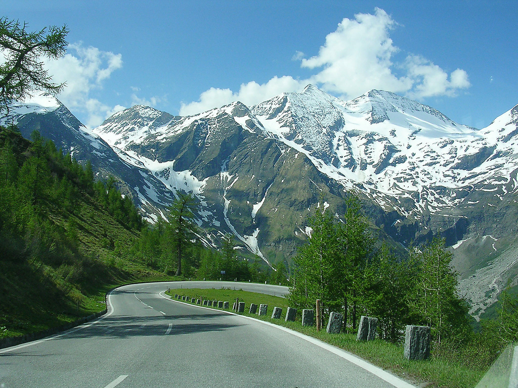
The Grossglockner rises 3,798 meters in the Hohe Tauern range of southern Austria, on the border between the states of East Tyrol and Carinthia. It is the highest mountain in Austria and the highest peak in the Eastern Alps — the section of the Alps east of the Brenner Pass. The Grossglockner is significantly shorter than major Western Alps peaks like Mont Blanc (4,809m), Dufourspitze (4,634m), or the Matterhorn (4,478m), but its position as Austria’s high point gives it cultural prominence well beyond its altitude.
The name “Grossglockner” — sometimes spelled Großglockner in proper German — translates literally as “Great Bell-Ringer,” from groß meaning “great/large” and glocken meaning “bells.” The name derives from the bell-shape silhouette the mountain presents when viewed from certain angles, particularly from the south. The mountain has a smaller neighbor called the Kleinglockner (“Little Bell-Ringer”) at 3,770m — the two peaks are separated by a small col and connected by the famously exposed knife-edge summit ridge that is the crux of the standard climbing route.
Find Hotels, Flights & Trips for the World’s Best Hiking Destinations
The Global Summit Guide Travel Shop on Expedia — curated for outdoor adventurers, mountaineers, and serious hikers. Patagonia to the Alps. Nepal to the Rockies. Curated lodging for every region we cover.
Explore Travel Shop on Expedia →28 July 1800: The Prince-Bishop’s Expedition
The first ascent of the Grossglockner was made on 28 July 1800 by a four-man advance party from one of the most unusual expeditions in early Alps history. The expedition was organized and entirely funded by Prince-Bishop Franz Xaver Altgraf von Salm-Reifferscheidt-Krautheim (1749-1822) of the Diocese of Gurk in Carinthia. Salm-Reifferscheidt was a Catholic bishop with substantial Enlightenment-era interests in natural science, exploration, and surveying — a mix typical of educated European clergy of that period.
The Prince-Bishop’s expedition was extraordinary by every measure of early mountaineering:
- 62 people total: porters, support staff, scientists, surveyors, religious figures, and the climbers themselves
- Multiple days of supply movement: equipment cached at progressively higher elevations
- Construction of a wooden refuge on the mountain — the Salm-Hütte at approximately 2,800m, which still bears the Prince-Bishop’s name today
- Formal scientific and religious mission: the expedition included barometric measurement equipment for altitude verification and was framed as both natural philosophy and Catholic pilgrimage
The actual summit was reached by a four-man advance party:
- Martin Klotz — Carinthian carpenter and mountain man from Heiligenblut
- Sebastian Klotz — Martin’s brother, also a carpenter
- Mathias Hautzendorfer — Catholic priest and member of the expedition
- Joseph Orrasch — Catholic priest and member of the expedition
The four-man party pushed from the high camp to the summit on the morning of 28 July 1800. The Prince-Bishop himself, accompanying the climb from a slightly lower position, did not reach the summit. The Klotz brothers continued working as guides on the Grossglockner for decades afterward — establishing the local guide tradition that continues today in Heiligenblut and Kals am Grossglockner. The 1800 ascent predates the 1854-1865 Golden Age of Alpinism by half a century — making it one of the earliest documented major Alps first ascents in history, just 14 years after the 1786 Mont Blanc ascent that founded modern mountaineering.
Why the Salm-Reifferscheidt expedition matters historically. The Grossglockner first ascent is one of the great early demonstrations of organized European exploration applied to alpine terrain. Unlike the Mont Blanc race (1760-1786, motivated by Saussure’s scientific prize) or the later Golden Age of Alpinism (1854-1865, motivated by British amateur sport), the Salm-Reifferscheidt expedition was a state-sponsored church endeavor combining religion, science, and exploration in the Enlightenment Catholic tradition. The Prince-Bishop personally funded a 62-person expedition specifically to reach a mountain summit. That expense and effort — at a time when mountains were still considered obstacles rather than goals — established Austria’s Catholic clergy as among the earliest European institutional supporters of organized mountaineering.
1856: The Stüdlhütte and Johann Stüdl
The Grossglockner’s climbing infrastructure expanded significantly during the second half of the 19th century. The Stüdlhütte, the modern standard base camp for the normal route, was named for Johann Stüdl (1839-1925), a Prague merchant who became one of the most influential developers of Austrian alpine climbing infrastructure. Stüdl funded the construction of mountain huts and the Stüdlgrat ridge route (the technical alternative to the normal route) which bears his name. He was instrumental in founding the German and Austrian Alpine Club (DAV/ÖAV) in 1862, which became the institutional foundation for organized Austrian alpinism.
1880: Erzherzog-Johann-Hütte (Adlersruhe) — Highest Hut in Austria
In 1880, the Erzherzog-Johann-Hütte was constructed at 3,454m on the Adlersruhe (Eagle’s Rest) — making it the highest mountain hut in Austria. The hut sits on a shoulder of the Grossglockner directly below the summit ridge, providing the operational base for the final summit push. It was named after Archduke Johann of Austria (1782-1859), a Habsburg royal with strong interests in alpine culture. The hut has been rebuilt and expanded multiple times; the current building sleeps approximately 50 climbers.
1930-1935: The Grossglockner High Alpine Road
One of Austria’s defining 20th-century infrastructure projects was the Grossglockner High Alpine Road (Grossglockner-Hochalpenstrasse) — a 48-km paved road climbing over the Hohe Tauern range via the Hochtor Pass at 2,504m. Construction took place from 1930 to 1935 under engineer Franz Wallack, with workers laboring through harsh winters and difficult terrain. The road opened on 3 August 1935 and immediately became one of Austria’s most famous tourist attractions.
The road features 36 hairpin curves, climbs from approximately 800m in the valleys to 2,571m at the Edelweißspitze viewpoint, and provides views of the Grossglockner and Pasterze Glacier that previously required serious mountaineering to access. Approximately 900,000 visitors per year use the road, making it one of Austria’s most-visited tourist destinations. The road operates from approximately early May through early November depending on snow conditions. The 2026 toll is €40 per car for one day.
The Pasterze — Longest Glacier in the Eastern Alps
The eastern side of the Grossglockner is dominated by the Pasterze Glacier — the longest glacier in the Eastern Alps at approximately 8 kilometers in length. The Pasterze drains south-southeast from the Grossglockner massif and is among the most-monitored glaciers in Austria for climate change research. The glacier has retreated substantially since the mid-19th century, with documented loss accelerating significantly since 2000. The 2010s and 2020s have produced the fastest measured retreat rate in the glacier’s monitored history, with substantial implications for climbing route conditions and access patterns.
1981/1992: Hohe Tauern National Park Established
The Hohe Tauern National Park was established in stages: 1981 in Carinthia, 1983 in Salzburg, and 1992 in Tyrol. The combined 1,856 km² protected area is the largest national park in the Alps and the first national park established in Austria. The park contains the Grossglockner summit, the Pasterze Glacier, 266 other glaciers, and substantial biodiversity. Climbing the Grossglockner means crossing protected national park terrain — climbers should be aware of conservation rules including waste pack-out, drone restrictions, and off-trail movement limits.
January 2025: The Fatal Winter Ascent Court Case
In January 2025, a fatal winter ascent of the Grossglockner generated substantial Austrian media attention and became a major court case examining the responsibilities of alpine guides and climbing partners during deteriorating conditions. The incident — involving a climb that ran behind schedule combined with worsening winter conditions and disputed decision-making near the summit — reinforced the lesson that despite the Grossglockner’s lower altitude relative to Western Alps peaks, the mountain remains genuinely consequential in marginal conditions. The 2025 case influenced Austrian alpine community discussions about winter mountaineering ethics and guide responsibilities for the rest of the year.
Austria’s Highest Peak — and the Eastern Alps Anchor
The Grossglockner occupies a specific and valuable position in the Alps Classics constellation: it is the highest peak in the Eastern Alps and the only major national high point still climbed primarily by Austrians and Eastern European climbers rather than the international clientele that dominates Mont Blanc, the Matterhorn, or the Bernese Oberland peaks.
What makes the Grossglockner culturally distinct:
- The Eastern Alps tradition: Austrian, German, Hungarian, Czech, Slovak, and Polish climbers dominate the Grossglockner. Western European and American climbers more commonly attempt the Western Alps peaks. The result is a different cultural feel — more German-language guiding, more Eastern European hut culture, less of the international commercial guiding industry that has reshaped Zermatt and Chamonix.
- The price advantage: Guided 2-day Grossglockner programs cost approximately €700-€1,500 — a fraction of guided Matterhorn (CHF 4,000-8,500) or Mont Blanc (€2,800-5,500) programs. The Grossglockner is among the most affordable major Alps summits with full guide support, making it the standard “first major Alps” peak for many Eastern European and Austrian climbers.
- The lower-altitude entry point: At 3,798m, the Grossglockner is well below the altitude where AMS/HAPE/HACE become significant concerns. Climbers attempting their first major alpine summit avoid the altitude complications that affect Mont Blanc (4,809m) or Dufourspitze (4,634m) climbers. The Grossglockner is, in effect, the Alps’ most approachable “real mountaineering” experience.
- The Hohe Tauern National Park context: Climbers ascend through Austria’s largest protected nature reserve, with substantial conservation framing of the climbing experience. This is meaningfully different from the resort-town atmosphere of Zermatt or Chamonix.
As progression toward Western Alps peaks: The Grossglockner is excellent preparation for Mont Blanc, the Matterhorn, or other 4,000m Alps peaks. The exposed knife-edge summit ridge teaches movement discipline; the glacier travel teaches roped technique; the hut culture matches the operational pattern of harder peaks. Austrian climbing tradition includes a clear progression: Grossglockner → Wildspitze → Bernese Oberland → Mont Blanc → Matterhorn.
For Western climbers traveling to Austria: The Grossglockner is the natural standalone summit if you’re already visiting Austria for other reasons (skiing, business, family). It delivers a genuine Alps summit experience for substantially less expense and altitude complexity than the famous Swiss-French peaks — and provides a different cultural perspective on European mountaineering than the international commercial centers offer.
Grossglockner Historical Timeline
Carinthian carpenters Martin and Sebastian Klotz with priests Mathias Hautzendorfer and Joseph Orrasch reach the summit. The 62-person expedition was funded and organized by Prince-Bishop Franz Xaver von Salm-Reifferscheidt-Krautheim. Just 14 years after Mont Blanc.
Prague merchant Johann Stüdl begins his decades-long work funding mountain huts, ridge routes, and climbing infrastructure on the Grossglockner. His name lives on in the Stüdlhütte (modern standard base camp) and Stüdlgrat (technical ridge alternative).
The institutional foundation of Austrian alpinism — the same year as the Italian Alpine Club. The DAV/ÖAV builds out the hut and route network across the Eastern Alps over the following decades.
The Erzherzog-Johann-Hütte at 3,454m on the Adlersruhe shoulder becomes the highest mountain hut in Austria. Named after Archduke Johann of Austria. Provides the operational base for the final summit push.
The Stüdlgrat — the technical ridge alternative to the normal route — is established as a recognized climbing line. Becomes the route of choice for stronger alpinists wanting a harder Grossglockner challenge.
Under engineer Franz Wallack, the 48-km paved road over the Hochtor Pass at 2,504m is built. 36 hairpin curves climb from 800m to 2,571m at the Edelweißspitze viewpoint. Opens 3 August 1935. Transforms regional tourism.
Austrian climbing infrastructure expands substantially. Modern Stüdlhütte rebuild. Improved trail systems. Grossglockner becomes the standard “first major Alps” peak for Austrian and Eastern European climbers.
Austria’s first national park is established in stages: Carinthia 1981, Salzburg 1983, Tyrol 1992. The 1,856 km² protected area becomes the largest national park in the Alps. The Grossglockner sits at its center.
The Pasterze Glacier — longest glacier in the Eastern Alps at ~8 km — retreats at the fastest rate in its monitored history. Climbing route conditions and access patterns change substantially across two decades.
A January 2025 fatal winter ascent generates major Austrian media attention and becomes a court case examining alpine guide responsibilities. The case influences Austrian alpine community discussions throughout the year.
The 13.3 km / 1,300 m Grossglockner Mountain Run on 6 July and the Grossglockner Ultra-Trail on 24-27 July reaffirm the mountain’s status as a premier Eastern Alps endurance-sport venue.
The Grossglockner Routes
The Grossglockner has two principal climbing lines used by commercial expeditions: the Normal Route (the standard guided line) and the Stüdlgrat (the technical ridge alternative). Several other routes exist for experienced alpinists.
| Route | Side | Grade | First Ascent | Status |
|---|---|---|---|---|
| Normal Route via Adlersruhe | South / Kals | PD+ | 28 Jul 1800 (Salm party) | ● Open · Standard · Most climbed |
| Stüdlgrat (SW Ridge) | SW Ridge | AD- | 1880s | ● Open · Technical Alternative |
| Pallavicinirinne (North Couloir) | North | D / D+ | 1876 | ● Open · Experienced Alpinists |
| North Face Direct | N Face | D+ / TD | 1922 | ● Open · Elite Only |
| Hofmanns Weg (East Ridge) | E Ridge | AD | Various 1800s | ● Open · Less Common |
Normal Route via Stüdlhütte and Adlersruhe — The Commercial Standard
Grade: PD+ (Peu Difficile Plus) · Used by the substantial majority of climbers.
Approach (Day 1): From Kals am Grossglockner (1,325m), drive to the Lucknerhaus trailhead at 1,920m. Hike approximately 3-4 hours on a good trail with some scrambling sections to the Stüdlhütte at 2,801m. Sleep at the Stüdlhütte (~100 beds; reservation mandatory in peak season).
Day 2 — Summit Push: Pre-dawn alpine start at 3-4 AM. From Stüdlhütte:
- Stüdlhütte to Ködnitzkees glacier (2,801m → 3,100m): Initial approach across moraines onto the glacier. ~45 minutes.
- Across the Ködnitzkees (3,100m → 3,400m): Roped glacier travel up the gradual glacier slope. Crevasse hazard.
- Glockner-Leitl ascent (3,400m → 3,454m): Final climb to the Adlersruhe (Eagle’s Rest) shoulder.
- Erzherzog-Johann-Hütte at 3,454m: The highest mountain hut in Austria. Many teams stop briefly for hot drinks before the summit push.
- Adlersruhe to Kleinglockner (3,454m → 3,770m): Steeper snow and ice slopes with fixed cables in places. Crampons mandatory. ~1 hour.
- The Knife-Edge Summit Ridge (3,770m → 3,798m): The crux. A 50-meter knife-edge ridge between the Kleinglockner and the Grossglockner main summit with significant drops on both sides. Climbers traverse the ridge one at a time with belay protection. ~30 minutes including waiting time.
Total summit-day time: 3-5 hours up from Adlersruhe; same down. 5-7 hours up from Stüdlhütte; same down. Most teams descend all the way to the Lucknerhaus on Day 2.
Used by: All major Grossglockner guide operators (Austria Mountain Guides, local Kals/Heiligenblut guide services, ÖAV-certified guides).
Stüdlgrat — The Technical Ridge Alternative
Grade: AD- · First climbed: 1880s, established under Johann Stüdl’s influence on Austrian alpinism.
Character: The southwest ridge of the Grossglockner — a sustained technical climb on rock and mixed terrain. The Stüdlgrat is significantly more demanding than the Normal Route: 600+ meters of exposed scrambling and Grade III-IV rock climbing, with multiple short technical sections requiring confident movement and rope work. The route ends at the same Kleinglockner-to-Grossglockner knife-edge ridge as the Normal Route.
Why climbers choose it: The Stüdlgrat offers a substantially more rewarding climbing experience for stronger alpinists. The route is rarely crowded — most Grossglockner traffic stays on the Normal Route. The technical character builds skills relevant to harder Alps peaks like the Eiger, Matterhorn, or Mont Blanc Three Monts.
The trade-off: The Stüdlgrat requires real rock-climbing competence, not just glacier travel skills. Sections are exposed and committed. Retreat is more difficult than on the Normal Route. The route requires significantly better conditions — wet rock or fresh snow makes the Stüdlgrat substantially more dangerous. Most operators offer Stüdlgrat as a separate guided product (often with prerequisite skill verification) rather than including it in standard Grossglockner packages.
Starting point: Also from Stüdlhütte (the route’s namesake). Climbers begin earlier (2-3 AM) due to the longer climb time.
Pallavicinirinne — The North Couloir
Grade: D / D+ · First climbed: 1876 by Alfred Pallavicini’s party.
Character: A serious ice climb up the north couloir of the Grossglockner — among the classic Eastern Alps ice routes. The Pallavicinirinne involves sustained 50-55° ice climbing with substantial objective hazard from rockfall and seral collapse. The route is most often climbed in late winter or early spring when the ice is at its best; summer conditions are typically too dangerous due to rockfall.
Modern status: Open and still climbed by experienced ice alpinists. Climate change has visibly affected the ice quality and made the route more condition-dependent. Most climbers attempting the Pallavicinirinne have multiple Alps D-grade routes in their résumé and approach the climb in optimal conditions only.
The 1800 Original Salm-Reifferscheidt Route
The historic line: The 1800 first ascent approached from the Heiligenblut side via what is now broadly the Hofmanns Weg / east approach — different from the modern Normal Route. The Klotz brothers and their priest companions climbed through what is essentially the modern Pasterze Glacier area, ascended the eastern slopes, and gained the summit ridge from the east.
Why it’s no longer the standard: The 1800 approach is longer and more dangerous than the modern Normal Route from Kals. The Pasterze Glacier’s accelerated retreat has changed the lower terrain substantially. The Stüdlhütte-Adlersruhe-Normal Route system that emerged after 1880 provides a shorter, more sustainable, and more controllable climbing experience.
Modern status: Climbers can still approach from Heiligenblut via the historic line, but very few do. The route is occasionally undertaken by climbers seeking the historical experience or wanting a different approach to the mountain. The Klotz family’s continuing presence as guides in Heiligenblut means local knowledge of the historic line remains available — Heiligenblut guides can provide the historic approach if specifically requested.
The Kals-Side Approach & Hut Progression
Modern Grossglockner climbs use a two-hut progression: Stüdlhütte (first overnight) and Adlersruhe (operational summit base). The full progression from valley to summit:
The knife-edge summit ridge is the crux. The 50-meter ridge between the Kleinglockner (3,770m) and the Grossglockner summit (3,798m) is famously exposed — narrow snow ridge with significant drops on both sides. Climbers traverse one at a time with belay protection. In good conditions the ridge is psychologically demanding but technically straightforward; in marginal conditions (heavy snow, wind, ice) it can become genuinely dangerous. Most teams summit only the Grossglockner main summit; some climbers also summit the Kleinglockner as a separate objective. The exposure on this ridge is the single feature that distinguishes the Grossglockner from typical PD-grade alpine climbs.
Costs & 2026 Logistics
The Grossglockner is significantly more affordable than Western Alps peaks. The lower altitude, shorter program duration, less expensive Austrian guiding rates, and absence of premium-priced Swiss villages combine to produce guided 2-day programs at €700-€1,500 — a fraction of the cost of guided Matterhorn or Mont Blanc programs.
| Item | Cost | Notes |
|---|---|---|
| Climbing permit | €0 | No permit required — Austrian alpine peaks freely accessible |
| Grossglockner High Alpine Road toll (visitors) | €40/day | For visiting scenic viewpoints; not required for climbers |
| Stüdlhütte (per night, half-board) | €60-€85 | ÖAV members get ~30% discount; book months ahead in peak season |
| Erzherzog-Johann-Hütte / Adlersruhe (per night, half-board) | €65-€90 | Highest hut in Austria; ~50 beds; books out fast |
| Salm-Hütte (per night, half-board) | €55-€80 | Historic hut at 1800 expedition site; alternative approach |
| ÖAV guide fee (Normal Route, 2 days) | €650-€1,200 | Per climber for 1:1 or 1:2 ratio guiding |
| ÖAV guide fee (Stüdlgrat technical) | €900-€1,500 | Higher rate for harder technical climb |
| Kals or Heiligenblut lodging (per night) | €80-€180 | Significantly more affordable than Zermatt or Chamonix |
| Travel insurance (alpine coverage) | €50-€150 | Standard European alpine policy |
| Independent climber budget | €200-€400 | Including huts, gear assumed owned, 2-3 nights valley accommodation |
| Guided Grossglockner (Normal, 2-day) | €700-€1,500 (USD ~$800-$1,700) | ÖAV guide + Stüdlhütte + Adlersruhe + safety equipment |
| Total trip budget (guided, including travel) | $1,500-$3,500 USD | Including international flights, gear, weather contingency |
Why the Grossglockner is the Alps’ best price-to-experience ratio. The mountain delivers a genuine major-Alps experience — multi-hut progression, glacier travel, exposed summit ridge, ÖAV-certified guiding — for substantially less than equivalent Swiss or French programs. The reasons: (1) Austrian alpine guide rates are roughly 30-50% lower than Swiss IFMGA rates due to different market structures and lower cost-of-living overhead; (2) Austrian mountain huts are operated under a more institutional model (ÖAV/DAV system) with controlled pricing; (3) Kals and Heiligenblut are working Austrian alpine villages, not international resort destinations. Climbers building toward Mont Blanc or the Matterhorn often climb the Grossglockner first specifically because it provides a real alpine experience at significantly lower total cost — making it the natural budget-conscious first major Alps peak.
Stüdlhütte and Adlersruhe book out fast. Both huts have limited capacity (~100 beds Stüdlhütte, ~50 beds Adlersruhe) and book out 3-6 months ahead for peak summer dates. Reservations should be made via the Austrian Alpine Club (ÖAV) system. Guided clients have reservations handled by their operator; independent climbers must book themselves. Walk-up climbers without reservations are turned away at the huts during peak season.
Best Time to Climb & Eastern Alps Weather
The Grossglockner has a main climbing season from late June through mid-September. The mountain’s lower altitude (3,798m vs Western Alps 4,000ers) means the snow conditions and hut accessibility patterns are slightly different from the famous Swiss-French peaks.
| Period | Window | Conditions | Watch For |
|---|---|---|---|
| Ski Mountaineering | Late March – Mid-May | Stüdlhütte open for ski-touring; Adlersruhe winter operation limited | Full winter alpine skills required; January 2025 fatal incident reminder |
| Early Season | Late June – Mid-July | Climbing season opens; heavier snow on upper sections | Soft snow bridges; weather instability; route conditions vary substantially |
| Main Season | Mid-July – August | Most settled weather; warmest temperatures; hut bookings full | Afternoon thunderstorms; Stüdlhütte/Adlersruhe pressure; weekend traffic |
| Late Season | Early – Mid September | Drier conditions; thinner crowds; cooler temperatures | Earlier sunsets; first storms of new season; hut closures approaching |
| Huts Closed | Late September – Mid June | — | Winter climbers only with full self-sufficiency |
The 3-4 AM start pattern. Grossglockner summit days begin at 3-4 AM from Stüdlhütte (or earlier from Adlersruhe). The early start serves three purposes: (1) snow conditions on the Ködnitzkees glacier are firmer in pre-dawn cold, reducing crevasse hazard; (2) afternoon thunderstorms in the Hohe Tauern are common in summer, and climbers must be off the exposed knife-edge ridge by midday; (3) summit-day traffic on the Normal Route can produce bottlenecks at the knife-edge ridge — earlier starts beat the crowds. Climbers who sleep in past 5 AM almost always face elevated weather and traffic risk on the upper mountain.
Pasterze Glacier conditions are deteriorating. The Pasterze — the longest glacier in the Eastern Alps — has retreated dramatically since 2000 and continues retreating at accelerating rates. While the Pasterze itself is not crossed by the standard Normal Route from Kals, the broader glacier conditions across the Grossglockner massif have changed substantially. Crevasses on the Ködnitzkees and other route glaciers have opened, narrowed, and shifted compared to historical conditions. Check current ÖAV route condition reports (alpenverein.at) before trip planning. Spring/early-summer ski mountaineering involves substantial avalanche and seral collapse risk that the January 2025 fatal incident illustrated dramatically.
Essential Gear Checklist
Grossglockner gear demands are standard PD+ alpine kit. The altitude (3,798m) is lower than Western Alps 4,000ers, reducing cold-weather margin somewhat — but the famously exposed summit ridge requires full alpine climbing kit including helmet, harness, and proper crampon system.
Alpine Clothing System
- Synthetic or merino base layers (top + bottom)
- Mid-weight insulating layer (fleece or synthetic)
- Lightweight down or synthetic insulated jacket
- Quality hardshell jacket + pants (Gore-Tex or equivalent)
- Warm beanie + buff + sun hat
- Liner gloves + insulated climbing gloves
- Glacier sunglasses (Category 4) + goggles for wind
Footwear & Crampons
- Mountaineering boots B2 (semi-rigid): La Sportiva Trango, Scarpa Mont Blanc, Salewa Crow GTX
- Crampons with anti-balling plates (Petzl Vasak, Grivel G12, Black Diamond Sabretooth)
- Wool/synthetic socks (2-3 pairs) + liner socks
- Lightweight camp shoes for hut
Technical Hardware
- Climbing harness (lightweight)
- Climbing helmet (essential — rockfall on Normal Route is real)
- Ice axe (60-65cm general-mountaineering axe)
- 2 locking carabiners + 2 standard carabiners
- Belay device + prusik cord
- 2 prusiks + cordelette for crevasse rescue
- 2 alpine slings + 1 longer sling
- Glacier rope (8mm × 30-40m, typically guide-provided)
Hut & Personal Gear
- 30-40L technical alpine pack
- Hut sleeping bag liner (ÖAV requirement)
- Personal first aid kit + headlamp + spare batteries
- 1L+ insulated water bottle + electrolytes
- Trail food + summit-day energy bars/gels
- Sunscreen (high SPF), lip balm with SPF
- Cash (Euros) for hut extras and meal upgrades
- ÖAV/DAV membership card (if applicable) for hut discounts
Difficulty & What the Grossglockner Actually Demands
The Grossglockner is graded PD+ (Peu Difficile Plus) — same as Mont Blanc’s Goûter Route and harder than the Jungfrau (PD) but easier than the Matterhorn (AD+) or Dufourspitze (AD). Four specific characteristics define what the mountain actually demands:
1. The knife-edge summit ridge is psychologically demanding. The 50-meter ridge between the Kleinglockner (3,770m) and the Grossglockner summit (3,798m) is the most exposed terrain on the standard route. Narrow snow ridge with significant drops on both sides; climbers traverse one at a time with belay protection. The technical difficulty is moderate (snow walking with crampons), but the psychological exposure is substantial. Climbers who panic on exposed terrain — Matterhorn-style situations — will feel the Grossglockner ridge intensely. The exposure is briefer than on the Matterhorn or Eiger Mittellegi but no less real.
2. Glacier travel is genuine, not symbolic. The Ködnitzkees glacier crossing on the Normal Route involves real crevasses, snow bridges of variable stability, and the standard glacier hazards. Roped travel is mandatory. Crevasse rescue skills should be functional, not theoretical. Climbers without prior roped glacier experience need formal instruction before attempting the Grossglockner. The mountain’s lower altitude relative to Western Alps peaks doesn’t reduce the glacier hazard — if anything, faster-retreating glaciers have produced more visible crevasses than in past decades.
3. Afternoon thunderstorms are the principal weather hazard. Hohe Tauern summer thunderstorms can develop quickly, particularly during high pressure systems. Climbers caught on the exposed summit ridge or Adlersruhe shoulder in lightning conditions face substantial risk. The 3-4 AM alpine start exists precisely to avoid this scenario — climbers should be off the upper mountain before midday in summer. Teams that summit late and descend in afternoon weather face elevated risk on the knife-edge ridge and glacier crossing.
4. The Grossglockner’s “approachable” reputation can produce underprepared climbers. The mountain’s lower altitude and affordable guided programs attract climbers who would not attempt Mont Blanc or the Matterhorn. Most are well-prepared; some are not. Climbers who treat the Grossglockner as a “warm-up” without prior alpine experience, glacier training, or crampon competence routinely struggle on the route — and occasionally pay catastrophically. The January 2025 fatal winter ascent illustrated how quickly poor judgment becomes irreversible even on a peak that “looks approachable” on paper.
What the Grossglockner rewards: Climbers with prior 3,000m glacier experience (alpine 4,000ers, smaller Austrian/Italian peaks, or formal alpine instruction), comfort with exposed scrambling and snow ridge traversing, crevasse rescue training (formal or extensive practice), fitness for 8-10 hour summit days, and basic German-language facility for hut and guide communication (most guides speak English but the working language is German). As a first major Alps peak, the Grossglockner is excellent — it delivers a genuine alpine experience at moderate altitude and substantially lower cost than Western Alps peaks. As preparation for Mont Blanc, the Matterhorn, or the Bernese Oberland peaks, the Grossglockner is highly relevant — the hut culture, glacier travel, exposed ridge experience, and alpine-start discipline all transfer directly.
Featured Expedition Operators
Grossglockner guide operations are dominated by ÖAV (Austrian Alpine Club)-certified Austrian guides with deep knowledge of Hohe Tauern conditions. Below are the established operators running Grossglockner programs in 2026.
Austria Mountain Guides (Bergführer Kals/Heiligenblut)
The local Austrian mountain guide collective serving the Grossglockner from both the Kals and Heiligenblut sides. ÖAV-certified guides, many of whom are descended from local Carinthian and Tyrolean families with multi-generational guiding tradition — including descendants of the Klotz family present at the 1800 first ascent. The most natural operator choice for climbers prioritizing local guide knowledge. austriamountainguides.com/grossglockner
ÖAV Alpine Guides (Austrian Alpine Club)
The institutional alpine club running Austrian-Alps guiding programs. ÖAV-certified guides with strong reputation for safety and training. Often the most affordable structured guiding option for the Grossglockner. alpenverein.at
Bergführer Heiligenblut
The Heiligenblut mountain guide office — operating from the Carinthia side of the mountain, the historic 1800 approach village. Strong specialty in the historic approach route and Pasterze Glacier-side climbs. The natural choice for climbers wanting the historical experience. bergfuehrer-heiligenblut.at
Bergsteigerschule Kals
Mountaineering school in Kals am Grossglockner — the modern standard approach village. Runs structured Grossglockner programs including 1-3 day climbing courses for clients building toward the summit. Excellent for first-time alpine climbers seeking instruction alongside the climb. bergsteigerschule.at
SummitClimb Europe
International mountaineering operator with structured Grossglockner expedition programs partnered with local Austrian ÖAV-certified guides. Higher per-climber cost reflecting structured programming and English-language client management. summitclimb.com
Adventure Consultants
New Zealand-based international guiding company with Grossglockner programs run via partnerships with local Austrian guides. Often packaged with other Alps peaks (Wildspitze, Dachstein) for climbers building Eastern Alps progressions. adventureconsultants.com
Frequently Asked Questions
The Grossglockner rises to 3,798 meters (12,461 feet) in the Hohe Tauern range on the border between East Tyrol and Carinthia in southern Austria. It is the highest mountain in Austria and the highest peak in the Eastern Alps (the Alps east of the Brenner Pass). Despite being shorter than the major Western Alps 4,000m peaks like Mont Blanc, Dufourspitze, or the Matterhorn, the Grossglockner is still a serious alpine objective with genuine glacier travel, exposed ridge sections, and a narrow summit area. It sits within Hohe Tauern National Park — the first national park in Austria, established in 1981.
The first ascent of the Grossglockner was made on 28 July 1800 by a four-man party led by Carinthian carpenters Martin Klotz and his brother Sebastian Klotz, accompanied by two priests — Mathias Hautzendorfer and Joseph Orrasch. The expedition was organized and funded by Prince-Bishop Franz Xaver Altgraf von Salm-Reifferscheidt-Krautheim of Gurk (1749-1822), who had assembled an unusually large 62-person expedition over multiple days to reach the summit. The Klotz brothers and priests pushed through to the top on 28 July while the Prince-Bishop himself stopped slightly below. The 1800 ascent predates the 1854-1865 Golden Age of Alpinism by half a century and is one of the earliest documented major Alps first ascents — just 14 years after Mont Blanc.
The Normal Route via Stüdlhütte and Adlersruhe is the standard guided line, accounting for the majority of all Grossglockner ascents. Climbers approach from Kals am Grossglockner via the Lucknerhütte (1,920m), then climb 3-4 hours to the Stüdlhütte (2,801m) for the first overnight. Day 2 ascends the Ködnitzkees glacier to the Erzherzog-Johann-Hütte (Adlersruhe) at 3,454m — the highest mountain hut in Austria — and continues via the narrow snow ridge to the summit. The route is graded PD+ (Peu Difficile Plus). Total summit day from Adlersruhe: 3-5 hours up, similar down. The route involves glacier travel, fixed cables in places, and a famously exposed final 50-meter summit ridge between the Kleinglockner (3,770m) and the Grossglockner summit.
The Grossglockner is graded PD+ — easier than the Matterhorn (AD+), Dufourspitze (AD), or Eiger Mittellegi (PD+/AD), but harder than the Jungfrau (PD) or Mont Blanc Goûter Route (PD+). At 3,798m, the altitude is significantly lower than the Western Alps 4,000m peaks, making altitude sickness less of an issue. However, the famously exposed knife-edge summit ridge between the Kleinglockner and the main summit — a 50-meter section with significant drops on both sides — provides genuine alpine exposure that climbers underestimate at their peril. The route also crosses glaciated terrain with real crevasse hazard. As a progression peak toward the higher Alps 4,000ers or as a standalone Eastern Alps classic, the Grossglockner is excellent.
Guided 2026 Grossglockner climbs typically cost €700-€1,500 per climber (approximately $800-$1,700 USD) for the standard 2-day program including ÖAV mountain guide, Stüdlhütte and Adlersruhe reservations, and basic safety equipment. Hut reservations cost approximately €60-€90 per night with half-board. Independent climbers without a guide can budget under €250 for hut and approach access. The Grossglockner High Alpine Road toll (for visitors driving to viewpoints) is €40 per car for one day. The total trip budget including travel to Kals or Heiligenblut, lodging, gear, and weather contingency typically runs $1,500-3,500 USD for guided climbers — substantially less than Western Alps peaks like the Matterhorn or Mont Blanc.
The main Grossglockner climbing season runs from late June through mid-September, with July and August offering the most settled weather. The Stüdlhütte and Erzherzog-Johann-Hütte (Adlersruhe) operate from approximately mid-June through late September. Early season (late June-early July) often has more snow on the upper ridge — easier on some sections but slower overall. Late season (early September) typically offers drier conditions but shorter daylight. Ski mountaineering ascents are possible from late March through May for climbers with full winter alpine skills. The January 2025 fatal winter ascent — which later became a major Austrian court case — illustrated that winter climbing on the Grossglockner is a serious undertaking with little margin for error.
The Grossglockner is one of the most beginner-friendly major Alps peaks — but it is not a peak for complete beginners with zero alpine experience. Climbers should arrive with prior 3,000m alpine experience, basic mountaineering skills including cramponing and self-arrest, crevasse rescue training, comfort on exposed snow ridges, and fitness for 8-10 hour summit days. With formal alpine instruction (often included in 3-day Bergsteigerschule programs that culminate in a Grossglockner summit attempt), the Grossglockner is appropriate as a first major Alps peak. Climbers without any prior glacier or roped-travel experience should not attempt the Grossglockner without formal instruction first.
The Grossglockner sits in the Hohe Tauern range in southern Austria, on the border between East Tyrol and Carinthia. Coordinates: 47.0744°N, 12.6939°E. The mountain sits within Hohe Tauern National Park — Austria’s first national park, established in 1981 and covering 1,856 km² across three states (Salzburg, Tyrol, and Carinthia). The two main climbing approach towns are Kals am Grossglockner (Tyrol side) and Heiligenblut am Großglockner (Carinthia side). The famous Pasterze Glacier — the longest glacier in the Eastern Alps — flows down the mountain’s east side. The Grossglockner High Alpine Road (built 1930-1935) connects the two sides of the mountain via 36 hairpin curves and 48 km of paved road, making the Grossglockner one of the most accessible major Alps peaks for non-climbing tourists.
Grossglockner Map & Kals Weather
Grossglockner summit coordinates: 47°04’28″N 12°41’38″E (47.0744°N, 12.6939°E). The map below shows the summit’s position in the Hohe Tauern. Live weather is shown for Kals am Grossglockner (1,325m) — the main Tyrol-side staging village. Summit conditions are typically 18-22°C colder than Kals.
Grossglockner Huts & Logistics: Reservations, Access & Tips
Was this helpful?
🏔Related peaks nearby
🧭Explore & compare
Global Summit Guide is an independent mountaineering resource founded in 2026. The team combines first-hand trekking and climbing experience with in-depth research and professional health and nutrition review to help climbers choose objectives, prepare properly, and stay safe.
Health, altitude, and nutrition content is reviewed by Taylor Ludlow (Registered Nurse) and Brigg Hoopes (Nutritionist).
What We Don't Know Yet
Mountain information changes quickly. This box explains the limits of what this page can responsibly promise.
- Permit availability, reservation windows, quotas, and official fee rules may change after this page is updated.
- Guide-company prices, departure dates, guide ratios, included services, and cancellation rules can change without notice.
- Weather, snowpack, avalanche risk, road access, and route conditions can change quickly and may be different on your climbing dates.
- Route conditions, trailhead access, crevasse exposure, stream crossings, and rescue access may vary from published planning guidance.
- Total trip cost can change with flights, lodging, guide pricing, permits, gear rentals, transportation, and exchange rates.
Verify current conditions with official land managers, guide services, local forecasts, and current route reports before booking or climbing.
Part of this Global Summit Guide cluster
Explore the complete Mountains guide for more context, routes, planning links, and related resources.
Mountaineering, rock and ice climbing, glacier travel, and high-altitude activity are inherently dangerous and can result in serious injury or death. The information on Global Summit Guide is provided for general informational and educational purposes only and is not a substitute for professional instruction, qualified guiding, proper equipment, or your own judgment and experience.
Route conditions, weather, snowpack, permits, regulations, and hazards change constantly and may differ from what is described here. Details may be incomplete, out of date, or contain errors. Always verify current information with local authorities, certified guides, and official sources before making any decision in the mountains.
Nothing on this site is medical, legal, or financial advice. Our fitness, acclimatization, altitude, and nutrition content is general in nature; consult a qualified physician before beginning any strenuous exercise program or exposing yourself to high altitude.
You are solely responsible for your own safety and decisions. To the fullest extent permitted by law, Global Summit Guide and its team accept no liability for any loss, injury, damage, or expense arising from use of, or reliance on, this information. By using this site you acknowledge these risks and accept these terms.
Some links on this site may be affiliate links. If you buy through them we may earn a small commission at no extra cost to you; this never affects our recommendations.
Global Summit Guide recommendation path
Next Best Mountain to Research
Use these recommendations to continue the right planning path instead of stopping on one page.
Use current permit, weather, route, and operator information before booking or climbing.