
Last updated May 21, 2026
Jungfrau Climb Guide: Switzerland’s 4,158m Maiden, the Jungfraubahn & the 1811 Meyer Brothers First Ascent (2026)
On 3 August 1811 — eighteen years before the Eiger and 54 years before the Matterhorn — Swiss brothers Johann Rudolf and Hieronymus Meyer with chamois hunters Alois Volker and Joseph Bortis stood on the Jungfrau’s summit. They had climbed the long way: across the Aletsch Glacier via the Lötschenlücke. A century later, in 1912, the Jungfraubahn railway tunneled through the Eiger and Mönch to reach Jungfraujoch at 3,454m — Europe’s highest railway station and the gateway to one of the shortest summit approaches for any major 4,000m Alps peak. Here’s the verified 2026 planning data.
UNESCO World Heritage Site. The Jungfrau is part of the Swiss Alps Jungfrau-Aletsch World Heritage Site, inscribed by UNESCO in 2001 (expanded 2007) as the first natural World Heritage Site in the Alps. The protected area covers 824 km² of glaciated alpine landscape including the Jungfrau, the Mönch, the Eiger, and the great Aletsch Glacier — the longest glacier in the Alps at approximately 23 km. The designation recognizes both the outstanding natural beauty of the high alpine landscape and the importance of the glaciers for climate science. Climbers visiting the Jungfrau region are walking through some of the most strictly protected alpine terrain in Europe.
The History of The Jungfrau
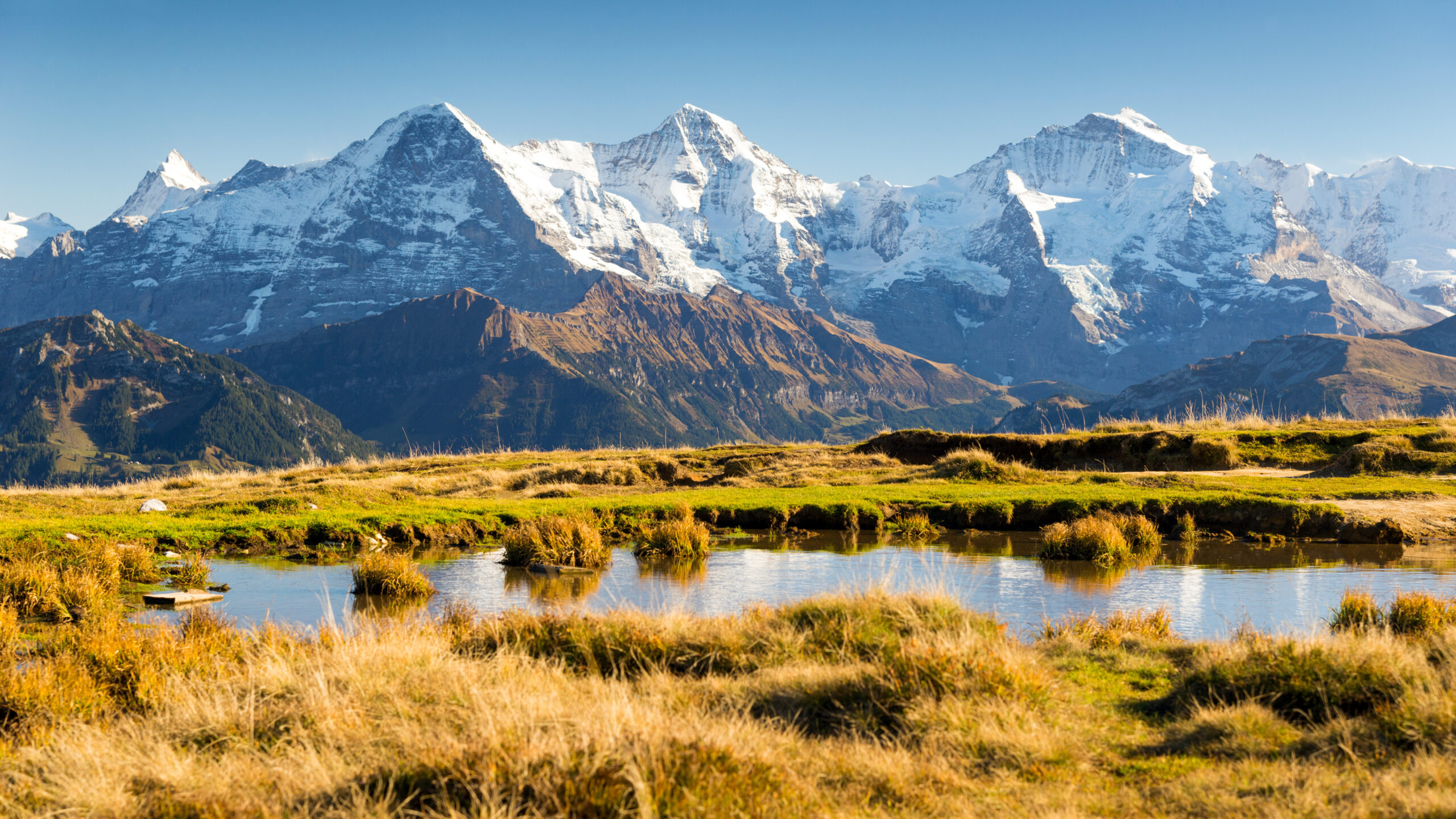
The Jungfrau rises 4,158 meters in the Bernese Alps of Switzerland, on the border between the cantons of Bern and Valais. It is the highest of the famous Eiger-Mönch-Jungfrau trio visible from the Bernese Oberland, and the third-highest peak in the Bernese Alps overall — after Finsteraarhorn (4,274m) and Aletschhorn (4,193m). The name Jungfrau means “Maiden” or “Virgin” in German, completing the local mythology in which the Monk (Mönch) eternally protects the Maiden (Jungfrau) from the Ogre (Eiger).
For centuries before the first ascent, the Jungfrau was considered one of the most unattainable peaks of the Alps — its long approach via remote glaciers and its imposing presence above the populated Bernese valleys made it a symbol rather than a climbing objective. The 1811 first ascent fundamentally changed the European understanding of what was possible in the high Alps, and the 1912 completion of the Jungfraubahn transformed the mountain again — this time into the most accessible 4,000m peak in Europe.
Find Hotels, Flights & Trips for the World’s Best Hiking Destinations
The Global Summit Guide Travel Shop on Expedia — curated for outdoor adventurers, mountaineers, and serious hikers. Patagonia to the Alps. Nepal to the Rockies. Curated lodging for every region we cover.
Explore Travel Shop on Expedia →3 August 1811: The Meyer Brothers’ First Ascent
The first ascent of the Jungfrau was made on 3 August 1811 by Swiss brothers Johann Rudolf Meyer (1768-1825) and Hieronymus Meyer (1769-1844) from Aarau, accompanied by chamois hunters Alois Volker and Joseph Bortis as guides. The Meyer brothers were the sons of Johann Rudolf Meyer the Elder (1739-1813), a wealthy Aarau silk merchant who funded the family’s pioneering exploration of the Bernese Alps in the early 19th century.
The 1811 climb did not approach from the modern north side via Lauterbrunnen — the Jungfrau’s north face was considered impossibly steep. Instead, the brothers and their guides traveled south to the Valais, climbed over the Lötschenlücke pass (3,178m), descended onto the Aletsch Glacier, and ascended the Jungfrau’s southeast snow slopes — essentially the same route used by elite alpinists today via the modern Hollandiahütte approach. The expedition required several days of glacier travel and high alpine camping in equipment that 21st-century climbers would consider profoundly inadequate.
The 1811 ascent made the Jungfrau the first major 4,000m Alps peak to be climbed — predating the Wetterhorn (1844), Mont Blanc dome variations, and the entire mid-19th-century “Golden Age of Alpinism” by decades. The Meyer brothers returned the following year (1812) for a second ascent that included their cousin Gottlieb Meyer, making the second-ever Jungfrau ascent a family affair. The climb was initially met with skepticism in some European scientific circles — the achievement was so unusual for its era that critics demanded additional confirmation, which subsequent ascents quickly provided.
Why the Meyer ascent matters historically. The 1811 Jungfrau first ascent is one of the most significant events in Alpine history but is far less famous than later climbs like the Matterhorn (1865) or the Eiger North Face (1938). It came during the Napoleonic Wars, before alpine clubs existed, before standardized climbing equipment, and before the concept of mountaineering as a sport had been formalized. The Meyer brothers were essentially the first people to combine scientific exploration, family wealth, and high alpine ambition in the way that would later define Victorian mountaineering. The family’s continued exploration of the Bernese Alps through the 1810s produced some of the earliest accurate maps of the region.
1828-1860s: The “Easy” New Routes
Through the 1820s and into the Golden Age of Alpinism in the 1850s-1860s, climbers searched for a route up the Jungfrau that didn’t require the multi-day Aletsch Glacier approach. In 1828, the first ascent from the northern Wengernalp side via the Rottalsattel was completed — establishing the broad outlines of what would become the modern route. The 1840s and 1850s saw repeated expeditions refining the route choice and developing the network of high alpine huts that supported regional climbing. By the 1870s, the Jungfrau had transitioned from a once-in-a-generation expedition to a standard objective for committed Alps mountaineers.
1893: The Mönchsjochhütte Built
In 1893, the Mönchsjochhütte was constructed by the Swiss Alpine Club at 3,650 meters between the Mönch and the Jungfrau — providing the first sustainable high camp for both peaks. The hut was rebuilt and expanded multiple times over the following century. Today it sleeps approximately 120 climbers and remains the operational base for the vast majority of Jungfrau and Mönch ascents. The hut’s existence is what makes the modern Jungfrau into a 2-day program rather than a multi-day expedition.
1 August 1912: The Jungfraubahn Reaches Jungfraujoch
On 1 August 1912 — Swiss National Day — the Jungfraubahn railway opened to Jungfraujoch at 3,454 meters, becoming the highest railway station in Europe (a record it still holds in 2026). The Jungfraubahn was the vision of Adolf Guyer-Zeller, a Zurich industrialist who began construction in 1896 — a 16-year engineering project that tunneled through the rock of the Eiger and the Mönch via what is essentially a vertical journey from Kleine Scheidegg (2,061m) to the heart of the high Alps.
The railway includes the famous Eigerwand station inside the Eiger’s North Face — a tunnel exit that briefly served as a viewing platform from inside the Mordwand itself. The Eigerwand station played a tragic role in mountaineering history: it was from there that railway workers attempted to rescue Toni Kurz during the 1936 North Face tragedy. The station was decommissioned in 2016 but the tunnel remains. The 1912 completion transformed the Jungfrau from a remote glaciated peak to one of Europe’s most accessible major mountains.
2001: UNESCO World Heritage Site Designation
In 2001, UNESCO inscribed the Swiss Alps Jungfrau-Aletsch as the first natural World Heritage Site in the Alps. The designation was expanded in 2007 to its current 824 km² protected area, including the Jungfrau, Mönch, Eiger, and the great Aletsch Glacier. The protection recognizes both the outstanding scenic value of the high alpine landscape and the global importance of the glaciers for climate science. Climbers on the Jungfrau cross into and out of the World Heritage Area depending on the specific route — the southeast side and Aletsch glacier are within the strictly protected zone.
2010s-2020s: Climate Change and Glacier Retreat
The Jungfrau has become a focal point of European climate change observation. The Aletsch Glacier — the longest in the Alps — has retreated approximately 3 kilometers since the late 19th century, with the rate of retreat accelerating dramatically since 2000. Sphinx Observatory at Jungfraujoch (3,571m) has provided continuous atmospheric data since 1937 — making it one of Europe’s most important high-altitude scientific stations. The Jungfrau region’s guide-led climate education programs have grown substantially in the 2020s, and the visible glacier retreat now factors into route condition reports for climbers planning ascents.
Jungfrau as Progression Peak — The Bernese Alps Training Ground
Among the world-famous Alps peaks, the Jungfrau occupies a specific and valuable niche: it is the most accessible 4,000m peak in the Alps that still delivers a genuine summit experience. The combination of railway access, established hut infrastructure, moderate technical difficulty (PD), and real glacier travel makes it ideal for climbers building toward harder objectives.
Climbing the Eiger? The Jungfrau is one of the best preparation peaks. The Mönchsjochhütte sleep, the alpine start, the glacier travel, the summit-day rhythm — all directly transfer. Eiger Mittellegi Ridge climbers who have done the Jungfrau first arrive at the Mittellegihütte with the operational pattern already established.
Climbing the Matterhorn? The Jungfrau’s modest exposure prepares climbers for the Matterhorn’s serious exposure. The fitness baseline, glacier competence, and alpine-start discipline all carry over.
Climbing Mont Blanc? Both peaks involve glacier travel at altitude with railway-assisted approaches. The Jungfrau’s 4,158m is slightly lower than Mont Blanc’s 4,809m but the operational pattern is similar enough to make it useful preparation.
Building toward Denali or Aconcagua? The Jungfrau is more relevant than its modest elevation suggests because of the genuine glacier travel, crevasse exposure, and altitude discipline at 4,000m+. Many guided programs explicitly package the Jungfrau as the Europe component of multi-peak training sequences toward higher objectives.
The flip side: Climbers attempting the Jungfrau without prior glacier or alpine experience often underestimate it. The railway access creates false confidence — but the summit day is a genuine 6-9 hour alpine climb with real consequences. The mountain rewards prepared climbers and punishes the underprepared. Several deaths each year on the Jungfrau and surrounding peaks involve climbers who treated the railway access as a substitute for alpine competence.
Jungfrau Historical Timeline
Johann Rudolf Meyer and Hieronymus Meyer with chamois hunters Alois Volker and Joseph Bortis make the first ascent via the Lötschenlücke and Aletsch Glacier. The Jungfrau becomes the first major 4,000m Alps peak climbed.
The Meyer brothers return with cousin Gottlieb Meyer for the second-ever ascent, confirming the 1811 climb to skeptical European scientific circles.
The first ascent from the northern Wengernalp side via the Rottalsattel establishes the broad outlines of what becomes the modern route.
The founding of the Alpine Club in London formalizes Victorian mountaineering. The Jungfrau becomes one of the most-attempted peaks of the Golden Age of Alpinism.
The Swiss Alpine Club constructs the Mönchsjochhütte at 3,650m between the Mönch and the Jungfrau, transforming both peaks into 2-day expeditions.
The 16-year tunneling project through the Eiger and Mönch begins. The railway will eventually reach the highest station in Europe.
The Jungfraubahn reaches Jungfraujoch at 3,454m on Swiss National Day, becoming Europe’s highest railway station — a record it still holds. The Jungfrau is transformed from a remote peak into one of Europe’s most accessible major mountains.
Construction begins on what becomes Sphinx Observatory at 3,571m. Operational from 1937, it becomes one of Europe’s most important high-altitude atmospheric research stations.
Eiger railway workers attempt to rescue Toni Kurz from the Eiger North Face via the Eigerwand tunnel exit station — among the most famous events linking the Jungfraubahn to alpine history.
The Swiss Alps Jungfrau-Aletsch is inscribed as the first natural UNESCO World Heritage Site in the Alps. Protected area expanded in 2007 to 824 km².
The famous viewing station inside the Eiger North Face stops operating as a passenger stop. The tunnel exit remains for emergency access.
The Aletsch Glacier — the longest in the Alps — continues retreating dramatically. Approximately 3 km lost since the late 19th century, with retreat accelerating substantially since 2000.
The Jungfrau Routes
The Jungfrau has one route used by virtually all commercial expeditions — the modern Jungfraujoch / Mönchsjochhütte / Rottalsattel line. The historic 1811 Meyer route remains a viable alternative for climbers seeking the original experience, and several other ridge lines exist for experienced alpinists.
| Route | Side | First Ascent | Status |
|---|---|---|---|
| Normal Route (Jungfraujoch / Rottalsattel) | SE | 1828 (northern variant); modern line via Mönchsjochhütte | ● Open · Standard Commercial |
| Meyer Route (Aletsch / Lötschenlücke) | S | 3 Aug 1811 (Meyer/Volker/Bortis) | ● Open · Historic |
| Rotbrätt Route | NW | Various 1880s-1900s | ● Open · Less Common |
| NE Ridge from Jungfraujoch | NE | 1881 | ● Open · Experienced Climbers |
| NW Wall | NW | 1971 (modern route) | ● Open · Expert Only |
Normal Route — Jungfraujoch / Mönchsjochhütte / Rottalsattel
Grade: PD (Peu Difficile) · Standard guided route — used by 95%+ of commercial expeditions.
Approach (Day 1): Train from Grindelwald or Lauterbrunnen via the Jungfraubahn through tunnels inside the Eiger and Mönch to Jungfraujoch at 3,454m — Europe’s highest railway station. From Jungfraujoch, walk 45-75 minutes across the Jungfraufirn glacier to the Mönchsjochhütte at 3,650m. The hut sleeps approximately 120 climbers; reservations essential during peak season.
Summit day (Day 2): Pre-dawn alpine start at 2-4 AM. From the hut, descend slightly onto the Jungfraufirn glacier, then climb southwest toward the Rottalsattel saddle at 3,885m — a notch between the Jungfrau and the Rottalhorn. From the Rottalsattel, climb the final summit ridge southeast on snow and ice slopes up to 40-45 degrees, reaching the summit at 4,158m. The summit ridge has significant exposure but no extreme technical difficulty.
Descent: Reverse the route — back down the summit ridge to the Rottalsattel, across the Jungfraufirn glacier to Mönchsjochhütte, then back to Jungfraujoch for the train. Total summit-day time: 6-9 hours round trip from the hut.
Total expedition: Standard 2-day program. Most guided programs add 1-2 acclimatization days — often climbing the Mönch (4,107m) the day before the Jungfrau attempt — producing 3-5 day total trips.
Used by: All major commercial Jungfrau guide operators (AlpinCenter Grindelwald, Zermatt Guides, Mountain Guides Lauterbrunnen, IFMGA freelance guides).
Meyer Route — The 1811 Historic Line
Grade: PD+ / AD- · First ascent: 3 August 1811 by Johann Rudolf Meyer, Hieronymus Meyer, Alois Volker, Joseph Bortis.
The original route: The Meyer brothers approached from the south side via the Lötschenlücke pass (3,178m) from the Valais, descended onto the Aletsch Glacier, and climbed the Jungfrau’s southeast snow slopes. This requires multi-day glacier travel rather than the modern train-and-hut approach.
Modern version: Climbers seeking the historic Meyer experience typically use the Hollandiahütte (3,235m) as the base, approached from the Lötschental valley via the long Aletsch Glacier walk. The summit is reached via essentially the same route the Meyer brothers climbed in 1811. This is a 3-4 day expedition rather than a 2-day program.
Modern status: Open and increasingly popular among climbers seeking authentic alpine experiences. The route requires genuine glacier competence, navigational skills, and self-sufficiency. Climbers must arrange Hollandiahütte reservations independently or via specialty operators — the route is not commonly run as a standard commercial program. Carries the UNESCO World Heritage Site protection in much of its terrain.
The Jungfraubahn — Engineering Marvel and Access Strategy
What it is: The Jungfraubahn (Jungfrau Railway) is a 9-km rack railway that climbs from Kleine Scheidegg (2,061m) through tunnels inside the Eiger and Mönch to Jungfraujoch at 3,454m. It is the highest railway station in Europe, a record it has held since opening on 1 August 1912.
How climbers use it: The Jungfraubahn is the gateway to the standard Jungfrau climb. Climbers travel by train from Interlaken Ost → Grindelwald → Kleine Scheidegg → Jungfraujoch. The full journey from Interlaken takes approximately 2 hours each way. From Jungfraujoch, climbers walk the 45-75 minute approach to the Mönchsjochhütte.
Pricing reality: The Jungfraubahn is among the most expensive railways per kilometer in the world. A roundtrip ticket from Grindelwald costs approximately CHF 220-260; from Interlaken approximately CHF 280-320. Climbers should book in advance during peak season — tickets sell out and standby capacity is limited. Some climbers find the railway cost a larger expense than the hut and guide combined for non-guided ascents.
Inside the mountain: The railway passes through stations carved inside the Eiger and Mönch, including the historic (now decommissioned) Eigerwand station that exited onto the Eiger’s North Face — the same tunnel from which workers attempted to rescue Toni Kurz in 1936. Modern trains stop briefly at Eismeer station inside the Eiger for viewing.
The Jungfraujoch / Mönchsjochhütte Progression
Standard Jungfrau climbs use Mönchsjochhütte as the single high camp. The full operational progression from Interlaken to summit:
The Mönch acclimatization option. The Mönch (4,107m) is the natural acclimatization peak for Jungfrau climbers. Both peaks share the Mönchsjochhütte as their staging base, and most operators offer a 3-day program: arrive at Mönchsjochhütte Day 1, climb Mönch Day 2, climb Jungfrau Day 3. The Mönch is technically similar to the Jungfrau but slightly easier and shorter — perfect preparation for the Jungfrau summit day. Climbers booking the Jungfrau standalone often regret not adding the Mönch when conditions and time allow.
Costs & 2026 Logistics
Like the Eiger, the Jungfrau requires no climbing permit — Swiss alpine peaks are freely accessible to anyone with the skills to climb them. The dominant costs are the Jungfraubahn railway, the Mönchsjochhütte, and (for guided climbers) the IFMGA guide fee.
| Item | Cost | Notes |
|---|---|---|
| Climbing permit | CHF 0 | No permit required — Swiss alpine peaks freely accessible |
| Jungfraubahn (Grindelwald → Jungfraujoch roundtrip) | CHF 220-260 | Premium-priced railway; Half-Fare Card and Swiss Travel Pass provide discounts |
| Jungfraubahn (Interlaken → Jungfraujoch roundtrip) | CHF 280-320 | Most common starting point for international climbers |
| Mönchsjochhütte (per night, half-board) | CHF 110-160 | SAC members get ~30% discount; book months ahead in peak season |
| IFMGA guide fee (Jungfrau, 2 days) | CHF 1,800-3,000 | Per climber for 1:1 or 1:2 guiding |
| IFMGA guide fee (Mönch + Jungfrau, 3 days) | CHF 2,800-4,500 | Mönch acclimatization day included |
| Grindelwald or Lauterbrunnen lodging (per night) | CHF 150-400 | Wide range; hotels, guesthouses, apartments |
| Travel insurance (alpine coverage) | CHF 80-200 | Standard European alpine policy |
| Independent climber budget (full Jungfrau trip) | CHF 1,200-2,500 | Including rail, hut, gear, 3-4 nights valley accommodation |
| Guided Jungfrau (Standard 2-day) | CHF 2,500-4,500 (USD ~$2,800-5,200) | IFMGA guide + hut + rail + safety equipment |
| Total trip budget (guided, including travel) | $4,000-7,500 USD | Including international flights, gear, weather contingency days |
Mönchsjochhütte books out. The hut’s ~120 bunks fill rapidly during the main climbing season (July-August). Reservations should be made 2-6 months in advance via the Swiss Alpine Club system. Guided clients have reservations handled by their operator; independent climbers must book themselves through the hut warden or SAC online system. Walk-up climbers without reservations will be turned away — there is no overflow shelter, and Jungfraujoch is not a viable bivouac location.
Half-Fare Card and Swiss Travel Pass. Climbers spending more than a few days in Switzerland should investigate the Swiss Federal Railway’s discount cards. The Half-Fare Card (approximately CHF 120 for one month) provides 50% off most Swiss train tickets including the Jungfraubahn. The Swiss Travel Pass includes free transportation on most trains plus 25% off the Jungfraubahn. For climbers booking the Jungfrau as part of a broader Swiss Alps trip (Matterhorn + Mont Blanc + Jungfrau, for example), these discounts can save CHF 200-400 across the trip.
Best Time to Climb & Bernese Alpine Weather
The Jungfrau has a main climbing season from mid-June through mid-September, with July and August offering the most settled weather and the longest daylight for summit days. The Mönchsjochhütte’s operating calendar shapes much of the practical season.
| Period | Window | Conditions | Watch For |
|---|---|---|---|
| Ski-Touring | Late March – Early June | Mönchsjochhütte open for ski-touring; some climbers attempt | Cold temperatures; full winter alpine skills required; not for non-skiers |
| Early Season | Mid-June – Early July | Climbing season opens; heavier snow on upper mountain | Snow bridges still soft; some weather instability; route conditions vary |
| Main Season | July – August | Most settled weather; longest daylight; warmest temperatures | Hut and railway crowds; reservation pressure; afternoon thunderstorms |
| Late Season | Early – Mid September | Drier rock and ice; thinner crowds; beautiful autumn light | Earlier sunsets; first storms of new season; hut closes mid-Sept |
| Mönchsjochhütte Closed | Late Sept – Late March | — | Hut closed; only winter parties operate |
Why the 2 AM start. Standard Jungfrau summit days begin between 2 AM and 4 AM from the Mönchsjochhütte. The early start exists for three reasons: (1) snow conditions are firmer in pre-dawn cold, reducing crevasse hazard and improving cramponing; (2) afternoon thunderstorms are routine in the Bernese Alps in summer, and climbers want to be off the summit and back to the hut before noon; (3) the Jungfraubahn return trains have schedules that make a noon-or-earlier return desirable. Climbers who arrive at the hut intending to “sleep in” until 5-6 AM almost always summit later than planned and face elevated weather risk on descent.
Glacier conditions are deteriorating. The Aletsch Glacier has retreated approximately 3 kilometers since the late 19th century, with retreat accelerating significantly since 2000. The result: more bare ice, more open crevasses, more rockfall as the formerly ice-cemented slopes thaw. The standard Jungfrau route conditions today are not the conditions of even 20 years ago. Climbers should check current conditions with local guides (AlpinCenter Grindelwald is the gold standard) before trip planning. Routes that were straightforward 30 years ago now sometimes require minor variations to bypass deteriorating sections.
Essential Gear Checklist
Jungfrau gear demands are standard alpine PD difficulty — full glacier kit, no extreme cold or fixed-rope demands. The mountain’s relative accessibility shouldn’t translate into reduced gear preparation: the summit day is a real 4,000m alpine outing.
Alpine Clothing System
- Synthetic or merino base layers (top + bottom)
- Mid-weight insulating layer (fleece or synthetic)
- Lightweight down or synthetic insulated jacket
- Hardshell jacket + pants (Gore-Tex or equivalent)
- Warm beanie + buff + sun hat
- Liner gloves + insulated climbing gloves
- Glacier sunglasses (Category 4) + goggles for wind/snow
Footwear & Crampons
- Mountaineering boots B2 (semi-rigid): La Sportiva Trango, Scarpa Mont Blanc, Salewa Crow GTX
- Crampons with anti-balling plates (Petzl Vasak, Grivel G12, Black Diamond Sabretooth)
- Wool/synthetic socks (2-3 pairs) + liner socks
- Lightweight camp shoes for hut
Glacier & Technical Hardware
- Climbing harness (lightweight)
- Climbing helmet
- Lightweight ice axe (60-65cm general-mountaineering axe)
- 2 locking carabiners + 2 standard carabiners
- Belay device or Munter hitch competence
- 2 prusiks + cordelette for crevasse rescue
- 1 alpine sling + 1 longer sling
- Glacier rope (8mm × 30-40m, typically guide-provided)
Hut & Personal Gear
- 30-40L technical alpine pack
- Hut sleeping bag liner (SAC requirement)
- Personal first aid kit + headlamp + spare batteries
- 1L+ insulated water bottle + electrolytes
- Trail food + summit-day energy bars/gels
- Sunscreen (high SPF), lip balm with SPF
- Cash (CHF) for hut and railway extras
- Swiss Half-Fare Card or Swiss Travel Pass (if applicable)
Difficulty & The Railway Trap
The Jungfrau’s modest PD grade and Jungfraubahn access make it sound like a casual outing. It isn’t. Four specific characteristics define what the Jungfrau actually demands:
1. The altitude transition is real. The Jungfraubahn lifts climbers from Grindelwald (1,034m) or Lauterbrunnen (796m) to Jungfraujoch (3,454m) in approximately 50 minutes. That’s a 2,400m+ altitude gain — substantially faster than most mountaineering progressions allow. Mild altitude sickness at Mönchsjochhütte is common; climbers who normally tolerate altitude well sometimes find the rapid Jungfraubahn ascent triggers headaches, nausea, or sleep disruption. The standard mitigation is the Mönch acclimatization day, but climbers attempting the Jungfrau as a single 2-day trip have less margin.
2. Glacier travel is genuine, not symbolic. The route from Mönchsjochhütte crosses the Jungfraufirn glacier — a working glacier with real crevasses, snow bridges, and seasonal hazard variation. Roped travel is non-negotiable. Crevasse rescue skills should be functional, not theoretical. Climbers attempting the Jungfrau without prior glacier experience need formal instruction (typically the IFMGA glacier travel courses) before the climb. The Eiger and Mont Blanc deaths each year include climbers who underestimated glacier hazards on neighboring peaks — the same principle applies to the Jungfrau.
3. The Rottalsattel-to-summit ridge has serious exposure. Once past the Rottalsattel, the final 270m of climbing involves an exposed snow and ice ridge with significant drops on both sides. The technical difficulty is modest (snow slopes to 45 degrees) but the exposure is psychological. Climbers who struggle with exposed terrain on the Matterhorn or the Eiger’s Mittellegi Ridge will also feel the exposure on the Jungfrau’s summit ridge — it’s less extreme but it’s there. Move efficiently and trust your guide’s pace.
4. Afternoon weather is the silent killer. Bernese Alps summer afternoons routinely produce thunderstorms with lightning, wind, and reduced visibility. Climbers who summit late and descend in afternoon weather face elevated risk on the exposed summit ridge, the crevassed Jungfraufirn glacier, and the walk back across the Jungfraujoch. The 2 AM start exists precisely to avoid this scenario. Climbers who insist on later starts because they’re “tired” usually pay for it on descent — sometimes catastrophically. The Mönchsjochhütte guardian and IFMGA guides will pressure climbers to start early for very good reasons.
What the Jungfrau rewards: Climbers with prior 3,000-4,000m glacier experience (Mont Blanc, Aletschhorn, Gran Paradiso), basic mountaineering skills including cramponing and self-arrest, crevasse rescue training (formal or extensive practice), altitude tolerance at 4,000m, and the ability to operate efficiently on a 6-9 hour summit day. As preparation for Mont Blanc, the Matterhorn, or the Eiger, the Jungfrau is excellent — it teaches the operational pattern (rail/hut/alpine-start/glacier travel/exposed ridge/return) at a modest difficulty level. As a “first 4,000m peak,” it’s appropriate for fit climbers with basic mountaineering training. As a “first big mountain,” it’s the wrong choice for climbers without any glacier or roped-travel experience.
Featured Expedition Operators
Jungfrau operations are dominated by IFMGA-certified Swiss guides with deep local knowledge of Mönchsjochhütte logistics and current glacier conditions. Below are the established commercial operators running Jungfrau programs in 2026.
AlpinCenter Grindelwald
Grindelwald-based mountain guiding center with direct access to Bernese Alps logistics. The most natural operator for climbers prioritizing local guide knowledge — Grindelwald-based IFMGA guides have decades of accumulated Jungfrau condition data. Runs standard 2-day Jungfrau programs and 3-day Mönch + Jungfrau combinations. alpincenter.ch/jungfrau
Zermatt Guides
Zermatt-based but running Swiss-Alps-wide programs including Jungfrau as part of broader Alps training sequences. Strong technical coaching reputation. Often packaged with Matterhorn programs for climbers building toward harder objectives. IFMGA-certified guides. zermattguides.ch
Bergführerverein Grindelwald
The official Grindelwald Mountain Guide Association — among the oldest and most prestigious guide collectives in the Alps. Centuries of accumulated local knowledge passed from generation to generation. Slightly more traditional structure than commercial operators; bookings handled through the association. bergsteigerzentrum.ch
SummitClimb Europe
International mountaineering operator with structured Jungfrau expedition programs that include preparation, acclimatization, and technical training. Higher per-climber cost but supports clients with less Alps experience seeking guided structure. summitclimb.com
Adventure Consultants
New Zealand-based international guiding company with Jungfrau programs run by IFMGA Swiss guides. Often packaged with other Alps peaks (Matterhorn, Mont Blanc, Eiger) for climbers building Seven Summits Europe progressions. adventureconsultants.com
Jagged Globe
UK-based expedition operator running Jungfrau Mönch combinations led by IFMGA guides. Strong reputation for UK and European client mentoring; longer-program format with included preparation days. jagged-globe.co.uk
Frequently Asked Questions
The Jungfrau rises to 4,158 meters (13,642 feet), making it the highest peak in the famous Eiger-Mönch-Jungfrau trio of the Bernese Alps. It is the third-highest peak in the Bernese Alps after Finsteraarhorn (4,274m) and Aletschhorn (4,193m). The mountain sits on the border between the cantons of Bern and Valais and is part of the Swiss Alps Jungfrau-Aletsch UNESCO World Heritage Site — the first natural World Heritage Site in the Alps.
The first ascent of the Jungfrau was made on 3 August 1811 by Swiss brothers Johann Rudolf Meyer and Hieronymus Meyer from Aarau, with chamois hunters Alois Volker and Joseph Bortis serving as guides. The Meyer brothers were the sons of Johann Rudolf Meyer the elder, a wealthy silk merchant who funded the family’s pioneering Alps exploration. The ascent climbed via the Lötschenlücke and the Aletsch Glacier — a vastly longer and more demanding route than today’s railway-accessed normal line. The 1811 climb made the Jungfrau the first major 4,000m Alps peak to be climbed.
The standard guided route ascends from Jungfraujoch railway station (3,454m) via the Mönchsjochhütte (3,650m) overnight base, then climbs the southeast side via the Rottalsattel saddle (3,885m) to the summit at 4,158m. The 1912 completion of the Jungfraubahn — a tunnel railway through the Eiger and Mönch — created what remains the highest railway station in Europe and one of the shortest summit approaches for any major 4,000m Alps peak. Climbers walk approximately 45-75 minutes from Jungfraujoch to Mönchsjochhütte, sleep at the hut, then climb the summit day via glacier travel and exposed snow slopes.
Guided 2026 Jungfrau climbs typically cost CHF 2,500-4,500 per climber (approximately $2,800-5,200 USD) including IFMGA guide, Mönchsjochhütte reservation, and Jungfraubahn access. The Jungfraubahn alone costs approximately CHF 220-260 roundtrip from Grindelwald or Interlaken — making it Europe’s most expensive railway per kilometer. The hut costs approximately CHF 110-160 per night including half-board. Independent climbers without a guide can budget under CHF 700 for hut and rail access. Total trip budget including travel to Grindelwald, lodging, gear, and weather contingency typically runs $4,000-7,500 USD for guided climbers.
Yes — substantially. The Jungfrau is technically less demanding than the Eiger’s Mittellegi Ridge: less exposure, less route-finding complexity, no fixed ropes needed on the standard route, and shorter summit days. The Jungfrau is graded PD (Peu Difficile / Little Difficult), while the Eiger Mittellegi Ridge is PD+/AD (Assez Difficile). The Jungfrau is often used as a progression peak before the Eiger or as an introduction to 4,000m glaciated alpinism. However, the Jungfrau still demands genuine glacier competence, crevasse rescue skills, altitude tolerance, and weather judgment — it is not a casual outing despite the easy railway access.
The main Jungfrau climbing season runs from mid-June through mid-September, with July and August offering the most settled weather and the longest daylight for summit days. Early season (June) can have heavier snow on the upper mountain. Late season (mid-September) often delivers drier conditions but shorter daylight. The Mönchsjochhütte typically opens late March for ski-touring season and operates continuously through summer until late September. Booking should be done well in advance — the hut and Jungfraubahn fill quickly during peak summer.
The standard Jungfrau climb is a 2-day program: Day 1 — train from Grindelwald or Lauterbrunnen via the Jungfraubahn to Jungfraujoch (3,454m), then 45-75 minute walk to Mönchsjochhütte (3,650m). Day 2 — pre-dawn alpine start at 2-4 AM, climb the southeast route to the Rottalsattel and summit (4,158m), then descend back through Mönchsjochhütte to Jungfraujoch for the train return (6-9 hours total). Most guided programs add 1-2 acclimatization climbs (often the Mönch at 4,107m) before the Jungfrau itself, producing 3-5 day total trips.
The Jungfrau is not a beginner peak in the absolute sense, but it is among the most beginner-friendly 4,000m peaks in the Alps. Climbers should arrive with: prior 3,000-4,000m glacier experience, basic mountaineering skills including cramponing and self-arrest, crevasse rescue training (formal or extensive practice), altitude tolerance at 4,000m, and basic comfort on exposed terrain. The Jungfrau is appropriate for fit climbers with formal alpine instruction (IFMGA glacier travel courses, for example) — but not for climbers with zero glacier or roped-travel experience. The Jungfraubahn railway access creates false confidence; the summit day is a real alpine outing.
The Jungfrau sits in the Bernese Alps of Switzerland on the border between the cantons of Bern and Valais, rising above the villages of Lauterbrunnen, Grindelwald, and Interlaken. Coordinates: 46.5366°N, 7.9625°E. The mountain forms the highest of the famous Eiger-Mönch-Jungfrau trio. Access is via the Jungfraubahn railway, which climbs through tunnels inside the Eiger and Mönch to reach Jungfraujoch — Europe’s highest railway station at 3,454m. The Jungfrau is part of the UNESCO Swiss Alps Jungfrau-Aletsch World Heritage Site, the first natural World Heritage Site in the Alps.
Jungfrau Map & Grindelwald Weather
Jungfrau summit coordinates: 46°32’12″N 7°57’45″E (46.5366°N, 7.9625°E). The map below shows the summit’s position in the Bernese Alps. Live weather is shown for Grindelwald (1,034m) — the main staging village. Summit conditions are typically 18-22°C colder than Grindelwald.
Was this helpful?
🏔Related peaks nearby
🧭Explore & compare
Global Summit Guide is an independent mountaineering resource founded in 2026. The team combines first-hand trekking and climbing experience with in-depth research and professional health and nutrition review to help climbers choose objectives, prepare properly, and stay safe.
Health, altitude, and nutrition content is reviewed by Taylor Ludlow (Registered Nurse) and Brigg Hoopes (Nutritionist).
What We Don't Know Yet
Mountain information changes quickly. This box explains the limits of what this page can responsibly promise.
- Permit availability, reservation windows, quotas, and official fee rules may change after this page is updated.
- Guide-company prices, departure dates, guide ratios, included services, and cancellation rules can change without notice.
- Weather, snowpack, avalanche risk, road access, and route conditions can change quickly and may be different on your climbing dates.
- Route conditions, trailhead access, crevasse exposure, stream crossings, and rescue access may vary from published planning guidance.
- Total trip cost can change with flights, lodging, guide pricing, permits, gear rentals, transportation, and exchange rates.
Verify current conditions with official land managers, guide services, local forecasts, and current route reports before booking or climbing.
Part of this Global Summit Guide cluster
Explore the complete Mountains guide for more context, routes, planning links, and related resources.
Mountaineering, rock and ice climbing, glacier travel, and high-altitude activity are inherently dangerous and can result in serious injury or death. The information on Global Summit Guide is provided for general informational and educational purposes only and is not a substitute for professional instruction, qualified guiding, proper equipment, or your own judgment and experience.
Route conditions, weather, snowpack, permits, regulations, and hazards change constantly and may differ from what is described here. Details may be incomplete, out of date, or contain errors. Always verify current information with local authorities, certified guides, and official sources before making any decision in the mountains.
Nothing on this site is medical, legal, or financial advice. Our fitness, acclimatization, altitude, and nutrition content is general in nature; consult a qualified physician before beginning any strenuous exercise program or exposing yourself to high altitude.
You are solely responsible for your own safety and decisions. To the fullest extent permitted by law, Global Summit Guide and its team accept no liability for any loss, injury, damage, or expense arising from use of, or reliance on, this information. By using this site you acknowledge these risks and accept these terms.
Some links on this site may be affiliate links. If you buy through them we may earn a small commission at no extra cost to you; this never affects our recommendations.
Global Summit Guide recommendation path
Next Best Mountain to Research
Use these recommendations to continue the right planning path instead of stopping on one page.
Use current permit, weather, route, and operator information before booking or climbing.