
Last updated September 17, 2026

Avalanche Gulch vs Clear Creek: Which Mount Shasta Route Fits You?
Avalanche Gulch and Clear Creek are not the same climb with different scenery. Avalanche Gulch is Mount Shasta’s classic spring snow route from Bunny Flat; Clear Creek is the lower-technical southeast route that becomes especially useful after the south-side snow deteriorates. Both reach the same 14,179-foot summit, both require the same $25 Summit Pass above 10,000 feet, and the better choice changes with the month and current conditions.

Choose Avalanche Gulch for spring snow climbing; choose Clear Creek for the usual late-summer pivot.
Avalanche Gulch is the stronger first choice when the south-side snow route is in condition. It has the simplest paved access, the most route information, established camps at Horse Camp and Helen Lake, and the classic crampon-and-ice-axe Mount Shasta experience. The trade-off is steep snow, a roughly 7,000-foot climb, and increasing rockfall around Red Banks as the route melts out.
Clear Creek is Mount Shasta’s least technical summit route when it is dry and you stay on route. It starts around 6,500 feet, climbs roughly 7,600–7,700 vertical feet, passes the natural springs around 8,480–8,600 feet, and often becomes the better option in July and August after Avalanche Gulch has deteriorated. The price of lower technical difficulty is loose volcanic scree, less obvious navigation and fewer route cues.
Neither route is “permit-free.” Current Mount Shasta climbing-ranger guidance requires the $25 Summit Pass above 10,000 feet, free wilderness permit and human-waste pack-out bag on both routes. Route choice should be based on season, snow surface, rockfall, access and your skills—not permit avoidance.
Avalanche Gulch vs Clear Creek at a glance
The route difference is much more about season and surface than about a dramatic difference in vertical gain.
| Factor | Avalanche Gulch | Clear Creek | What it means |
|---|---|---|---|
| Summit | 14,179 ft | 14,179 ft | Same altitude and same upper-mountain weather exposure. |
| Trailhead | Bunny Flat · 6,950 ft | Clear Creek · about 6,500 ft | The starting elevations are only a few hundred feet apart—not ~2,500 feet. |
| Vertical gain | About 7,000 ft | About 7,600–7,700 ft | Clear Creek is longer physically, but not by the 2,450-ft margin sometimes published. |
| One-way distance | Varies with snow line and exact line | Rangers describe about 6 miles | Both are full-day/multi-day mountain efforts. |
| Normal high camp | Helen Lake ~10,400 ft | Springs ~8,480–8,600 ft | Clear Creek generally leaves more summit-day vertical if camping low. |
| Typical surface | Spring snow/ice; later scree + rockfall | Snow early; loose ash/scree in dry summer | The routes peak at different times of year. |
| Technical character | Steep snow climb requiring snow-travel skills in normal season | Least technical Shasta route when dry and on route | Clear Creek is not automatically easier when covered in fresh or firm snow. |
| Key hazard | Long falls, rockfall, warming snow, Red Banks | Navigation, loose scree, rockfall, off-route glaciated terrain | Clear Creek avoids Red Banks but does not remove mountain hazard. |
| Best planning window | Usually Apr–Jun; sometimes July | Usually July–Aug as late-season option | Season should often decide before preference. |
| Summit Pass | $25 above 10,000 ft | $25 above 10,000 ft | No permit advantage for Clear Creek. |
| Wilderness permit | Required · free | Required · free | Self-issue at open trailheads/ranger locations. |
| Best for | Classic first Shasta snow climb in good spring conditions | Dry late-season ascent, less technical terrain and solitude | Choose the mountain you actually have—not the route you planned months ago. |
Two sides of the same volcano
Avalanche Gulch approaches from the south/southwest at Bunny Flat. Clear Creek approaches the southeast side by a longer unpaved road system.
The best line migrates around the mountain as the snowpack changes.
Mount Shasta’s route calendar is unusual because the standard south-side climb can become objectively worse as summer improves elsewhere. In a normal year, Avalanche Gulch is a spring snow climb. As the south side melts and rockfall increases, Clear Creek’s east/southeast terrain often becomes the more practical lower-technical choice—even though the route itself becomes drier, looser and less like classic snow mountaineering.

Avalanche Gulch: Bunny Flat to Red Banks and Misery Hill
The Avalanche Center calls this Mount Shasta’s classic and most popular route and describes roughly 7,000 vertical feet of ascent.
Paved primary trailhead. Current permits, Summit Passes and waste bags are generally self-issued here when open and stocked.
Sierra Club alpine hut, seasonal spring water and lower camping. Useful for a slower acclimatization plan.
Typical two-day high camp. Exposed to wind and weather; “lake” is a snow basin, not a dependable liquid-water source.
Steep route crux zone. Snow/ice and rockfall conditions change through the season. Rangers emphasize that 1,700 vertical feet remain above Red Banks.
Continue above Red Banks to Misery Hill, then cross the broad upper plateau to the true summit pinnacle.
The descent reverses the route. Limited visibility can pull climbers onto the wrong side of the mountain, so navigation matters even on the standard line.
Clear Creek: long, loose and easier to underestimate
The Avalanche Center calls Clear Creek the easiest non-technical route—provided you stay on route.
Current local guide itineraries place the trailhead around 6,500 ft. In spring 2026 the road was graded, and by summer rangers reported 2WD access possible, though conditions can deteriorate.
Common base-camp area and dependable seasonal water source. Rangers ask climbers to camp away from the spring head and protect fragile vegetation.
The route is not a maintained summit trail. Climbers follow use trails and landmarks; late summer can be a sustained volcanic-scree ascent.
Rangers specifically advise remembering where you crest this section because descending into the wrong line can lead toward steeper, glaciated or rockfall-prone terrain.
Snow or ice may persist even in otherwise dry late-season conditions. Gear requirements must follow the actual surface.
Rangers describe roughly six miles and about 7,000+ vertical feet one way. Strong climbers can day-climb it; most should plan two or three days.

A dry route can be less technical and more exhausting at the same time.
Clear Creek’s late-summer character is often a long ascent on volcanic dirt, ash and scree. That lowers the need for steep-snow technique but increases the value of trekking poles, route memory, efficient pacing and patience. Its “easiest” label describes technical difficulty—not total effort.

Match the route to the month—not the other way around
Guide services and rangers move around Shasta as snow coverage changes. Your route plan should do the same.
Avalanche Gulch begins
Snow route may be good, but avalanche hazard and winter storms remain important. Clear Creek road access can still be blocked.
AG prime window
Classic south-side snow climbing when refreeze and coverage cooperate. This is the heart of the traditional Avalanche Gulch season.
Transition
Rockfall rises as the south side melts. Clear Creek becomes increasingly relevant depending on access and snow coverage.
Clear Creek window
Shasta Mountain Guides commonly uses Clear Creek as a late-summer nontechnical route while south/west guide operations wind down.
Condition first
Clear Creek may remain the preferred late-season route, but fresh snow or early storms can instantly restore full mountaineering conditions.
The mountain itself showed when to switch routes
The 2026 season is a useful example of why evergreen route rankings are weaker than condition-based decisions.
| 2026 date | Avalanche Gulch | Clear Creek | Planning lesson |
|---|---|---|---|
| Late April | Bunny Flat open; spring snow climbing developing | Trailhead still about 2 miles out due to snow/downed trees | Road access alone can make Clear Creek the wrong early-season choice. |
| May 20 | Primary climbing season underway | All wilderness trailheads reported open; road still rougher | Both become viable, but south-side snow is usually the more logical objective. |
| June 22–26 | Rangers stopped recommending AG as rockfall increased | Rangers suggested less-experienced climbers consider Clear Creek | The preferred route can flip while the summit is unchanged. |
| July 16 | South/west guide operations had ended | Late-season east-side route increasingly appropriate | Summer does not mean “better AG weather”; melting snow can make AG worse. |
| Sept. 4–16 | Not recommended: discontinuous snow and abundant rockfall | Still described as best late-season option for most people, but new snow/ice made it less forgiving | Even Clear Creek can return to full mountaineering conditions overnight. |

Snow melt changes the hazard instead of removing it.
On Avalanche Gulch, warming and melt-out can expose loose rock above the climbing line and create firm-to-soft surface transitions that complicate both ascent and descent. On Clear Creek, dry conditions reduce snow-travel demands but reveal long loose volcanic slopes. The correct question is not “Which route is safer?” but “Which route currently has the hazards my team is best prepared to manage?”

Permits do not decide between Avalanche Gulch and Clear Creek
The current Mount Shasta regulation applies by elevation, not by which of these two routes you choose.
| Requirement | Avalanche Gulch | Clear Creek | Current rule |
|---|---|---|---|
| Summit Pass | $25 | $25 | Required above 10,000 ft even if you do not intend to summit. |
| Wilderness permit | Required · free | Required · free | Self-issue at open trailheads or designated ranger locations. |
| Human-waste pack-out bag | Required | Required | Pack out human waste within Mount Shasta Wilderness. |
| Trailhead availability | Bunny Flat usually has the longest reliable access season | Road access is more seasonal | Check current ranger conditions before driving. |
| Quota / lottery | No summit lottery | No summit lottery | Permit logistics are simpler than Whitney/Rainier, but still mandatory. |
Do not use one fixed gear list for both routes all season
Avalanche Gulch is normally a snow climb. Clear Creek can shift from snow climb to dry scree route and back to icy conditions after one storm.
Ice axe, crampons and helmet
The Avalanche Center explicitly describes these as core equipment for the route. Self-arrest and efficient crampon technique need to be practiced before summit day.
Helmet, axe and crampons recommended
Current Clear Creek guidance says these remain appropriate whenever snow is on route. A “nontechnical” label does not make firm snow safe in trail shoes.
Poles and helmet can become more useful than crampons
Rangers have documented dry late-season periods when axe and crampons were unnecessary. Trekking poles help on loose scree. Check the current report, not last year’s packing list.
Full kit can return overnight
Fresh September snow in 2026 turned previously dry ground slick and icy. Early-season-style tools may become mandatory again even though the calendar says late summer.
Beacon, shovel and probe when conditions demand
Winter and spring snowpack can create avalanche hazard. Carry rescue equipment only with the training to recognize avalanche terrain and use the system effectively.
Navigation, insulation and headlamp
Whiteout, strong wind and altitude do not care which route is easier. Carry redundant navigation, emergency layers, water strategy and enough light for a delayed descent.
Clear Creek avoids Red Banks—but it does not remove risk
Each route concentrates risk differently. That is why “safer route” is too broad without a date and conditions.
Steep snow, long falls and rockfall
- Firm morning snow can create long slide-for-life falls.
- Warming snow changes crampon and self-arrest performance.
- Red Banks and adjacent terrain become increasingly rockfall-prone as snow melts.
- Whiteout above Red Banks can make the broad upper mountain confusing.
- Late descent increases exposure to soft snow and falling rock.
Route-finding, loose terrain and off-route consequences
- Long ash/scree slopes increase fatigue and slip risk.
- There is no official trail to the summit.
- Descending the wrong line can move a team toward glaciers or steeper terrain.
- Upper-route rockfall remains possible.
- Snow patches can require full snow-climbing equipment even when most of the route is dry.

Above 13,000 feet, route labels matter less than weather and judgment.
Both routes eventually enter Mount Shasta’s exposed upper mountain, where wind, cold, cloud, altitude and fatigue become dominant. Rangers repeatedly emphasize the top 3,000 feet because a route that felt straightforward lower down can become a serious navigation and exposure problem near the summit.

Which route should you choose?
The route decision becomes simple when you start with season, surface and skill rather than crowds or permit myths.
You want the classic snow-mountaineering route and it is still in season.
- It is spring or early summer and the route has continuous, supportable snow.
- You are trained with crampons, ice axe and self-arrest.
- You want the most documented route and simplest access.
- You prefer a Helen Lake high camp around 10,400 feet.
- Current ranger guidance still considers the route appropriate.
The south side has deteriorated or you want the least technical dry-season route.
- It is July or August and Avalanche Gulch rockfall/snow coverage has deteriorated.
- You are comfortable navigating without a maintained summit trail.
- You can tolerate a long scree/ash ascent and descent.
- You want a quieter side of the mountain.
- The access road is open and current snow conditions match your equipment.

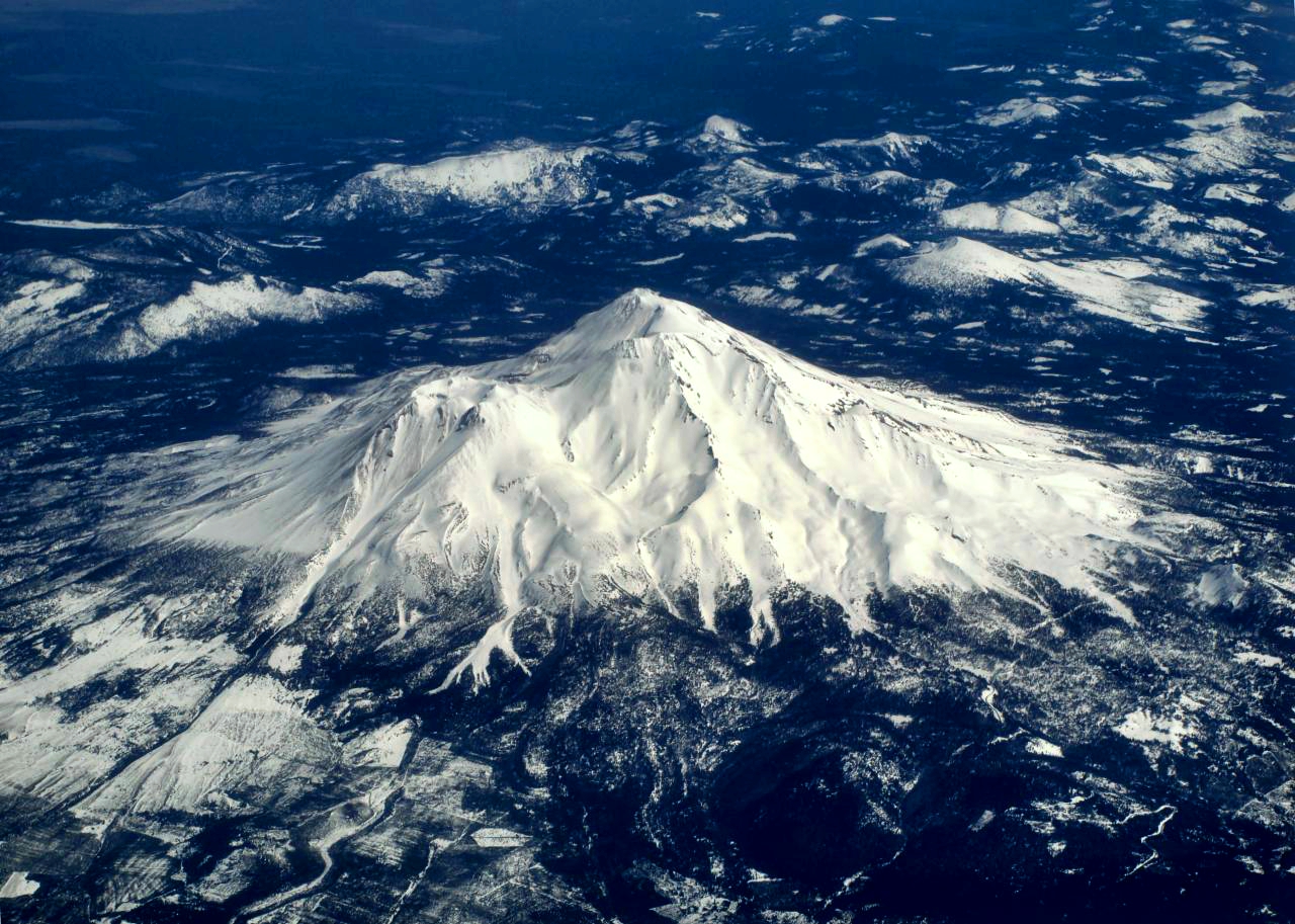
One mountain, very different seasonal faces
The broad cone hides how quickly snow distribution and objective hazard change by aspect. Poupouille · Free Art License.


Bunny Flat makes Avalanche Gulch easier to access—not easier to climb
The paved road and established approach reduce logistics, but the route above Helen Lake is still serious snow-mountaineering terrain. Srishti Sethi · CC BY-SA 4.0.

No defensible route-wide summit-success percentage
The old comparison published precise-looking percentages without a reproducible denominator. They are removed here.
We do not know the denominator.
Mount Shasta does not publish a route-by-route database of everyone who starts and everyone who summits. Without that population, a 50%, 60% or 70% figure is not auditable.
The same route changes category.
A June Avalanche Gulch snow climb and an August Avalanche Gulch rockfall slog are not comparable attempts. The same is true of snowy and fully dry Clear Creek ascents.
Current route condition + team readiness
Use the Avalanche Center’s route status, your team’s snow/ice skills, altitude fitness, weather forecast and turnaround discipline. Those inputs are more actionable than an invented historical percentage.
What owns the current facts
The Mount Shasta Avalanche Center / climbing-ranger program is the primary source for current rules, access and route conditions.
Mount Shasta Avalanche Center — current conditions
Primary authority used for September 2026 access, required Summit Pass/wilderness permit/waste bag, and the current condition distinction between Avalanche Gulch and Clear Creek.
Avalanche Gulch route description
Used for Bunny Flat/Horse Camp/Helen Lake route anatomy, equipment expectations, roughly 7,000 feet of ascent and the usual April–June season.
Clear Creek route description
Used for the “easiest non-technical route” wording, springs/base-camp area, off-route hazard and loose late-season surface.
Clear Creek elevation & itinerary
Current local-guide itinerary places the Clear Creek trailhead at 6,500 feet and camp around 8,600 feet. Ranger route descriptions independently put the route at roughly six miles and 7,000+ vertical feet one way.
Shasta Mountain Guides — route seasons
Current local guide source used for the practical seasonal split: south/southwest routes in late April–early June and Clear Creek commonly in July–August as a late-summer nontechnical option.
Methodology
Route facts are reported as ranges when the line changes with snow cover. Current condition statements are date-stamped. No route success rate is published without a reproducible attempt denominator, and equipment is tied to actual surface conditions rather than a fixed month.
Avalanche Gulch vs Clear Creek FAQ
The visible answers below match the FAQ schema.
Which is easier, Avalanche Gulch or Clear Creek?
Clear Creek is generally Mount Shasta’s least technical summit route when it is dry and you stay on route, but it remains a roughly 7,600-foot ascent with loose scree and meaningful route-finding. Avalanche Gulch is the classic first snow-climbing route when spring conditions are good, but it requires stronger crampon, ice-axe and self-arrest skills.
Does Clear Creek require the $25 Mount Shasta Summit Pass?
Yes. Current ranger guidance says the $25 Summit Pass is required above 10,000 feet on Mount Shasta even if you do not plan to reach the summit. That applies to both Avalanche Gulch and Clear Creek. A free wilderness permit and human-waste pack-out bag are also required.
How high is the Clear Creek trailhead?
Current local-guide itineraries place the trailhead around 6,500 feet. That makes the summit gain roughly 7,600–7,700 feet. The natural springs and common camp are around 8,480–8,600 feet.
What is the best season for Avalanche Gulch?
The Mount Shasta Avalanche Center says the route is usually best from April through June and sometimes July. Shasta Mountain Guides typically operates south/southwest routes from late April through early June. The exact window changes with annual snowpack and heat.
What is the best season for Clear Creek?
Clear Creek is mainly a mid- to late-summer route. Local guides commonly use it in July and August, and the Avalanche Center often recommends it after south-side snow routes deteriorate. Always verify road and upper-route conditions.
Do I need crampons and an ice axe on Clear Creek?
When snow is present, climbing rangers recommend helmet, ice axe and crampons. In fully dry late-summer conditions rangers have documented periods when axe and crampons were unnecessary. Recent snow can make them necessary again overnight, so use the current condition report.
Which route is better for a first Mount Shasta climb?
Avalanche Gulch is usually the better first route for someone who wants a classic snow-mountaineering climb and already has basic crampon, ice-axe and self-arrest skills. Clear Creek can be the lower-technical option in dry late summer, but its navigation and endurance demands should not be underestimated.
Is Clear Creek safer than Avalanche Gulch?
Not categorically. It avoids the Red Banks zone and can be a better late-season choice once Avalanche Gulch becomes rockfall-prone, but Clear Creek has loose terrain, navigation risk, upper-mountain rockfall and serious consequences if you wander toward glaciated terrain. Current conditions should decide.
Pick Avalanche Gulch in its snow season. Pick Clear Creek when the season moves east.
Avalanche Gulch is the classic Mount Shasta experience because it combines straightforward access with real spring snow climbing. Clear Creek is valuable because it extends the climbing season with a lower-technical southeast line after the south side deteriorates. Neither route removes altitude, weather, permits or judgment—and neither should be chosen from an old calendar without checking the current mountain.
Open the Complete Mount Shasta GuideRoutes, permits, gear, weather & progression
This page owns the Avalanche Gulch vs Clear Creek decision. Use the pages below for the complete mountain plan, broader route comparison, current logistics and next-step Cascade objectives.
Compare, Then Plan the Climb
Go deeper on each mountain in this comparison — full guides, permits, routes and season.
Was this helpful?
🏔More comparisons
🧭Explore & compare
Global Summit Guide is an independent mountaineering resource founded in 2026. The team combines first-hand trekking and climbing experience with in-depth research and professional health and nutrition review to help climbers choose objectives, prepare properly, and stay safe.
Health, altitude, and nutrition content is reviewed by Taylor Ludlow (Registered Nurse) and Brigg Hoopes (Nutritionist).
What We Don't Know Yet
Mountain information changes quickly. This box explains the limits of what this page can responsibly promise.
- Weather, snowpack, avalanche risk, road access, and route conditions can change quickly and may be different on your climbing dates.
- Route conditions, trailhead access, crevasse exposure, stream crossings, and rescue access may vary from published planning guidance.
- Comparisons simplify complex decisions; the better mountain depends on current conditions, skills, timing, budget, and risk tolerance.
- Visa, passport, vaccination, border, insurance, and local transportation rules may change before your trip.
Verify current conditions with official land managers, guide services, local forecasts, and current route reports before booking or climbing.
Mountaineering, rock and ice climbing, glacier travel, and high-altitude activity are inherently dangerous and can result in serious injury or death. The information on Global Summit Guide is provided for general informational and educational purposes only and is not a substitute for professional instruction, qualified guiding, proper equipment, or your own judgment and experience.
Route conditions, weather, snowpack, permits, regulations, and hazards change constantly and may differ from what is described here. Details may be incomplete, out of date, or contain errors. Always verify current information with local authorities, certified guides, and official sources before making any decision in the mountains.
Nothing on this site is medical, legal, or financial advice. Our fitness, acclimatization, altitude, and nutrition content is general in nature; consult a qualified physician before beginning any strenuous exercise program or exposing yourself to high altitude.
You are solely responsible for your own safety and decisions. To the fullest extent permitted by law, Global Summit Guide and its team accept no liability for any loss, injury, damage, or expense arising from use of, or reliance on, this information. By using this site you acknowledge these risks and accept these terms.
Some links on this site may be affiliate links. If you buy through them we may earn a small commission at no extra cost to you; this never affects our recommendations.
Global Summit Guide recommendation path
Next Best Mountain to Research
Use these recommendations to continue the right planning path instead of stopping on one page.
Use current permit, weather, route, and operator information before booking or climbing.