
Mount Shasta Climb Guide: California’s Sacred Volcano, the Avalanche Gulch Route & the 1854 Elias Pearce First Ascent (2026)
On 14 August 1854, Elias Pearce led a small party from the gold-rush town of Yreka up what is essentially the modern Avalanche Gulch route — completing the first verified European-American ascent of a mountain the Winnemem Wintu, Shasta, Karuk, Modoc, Klamath, Atsugewi, and Achumawi peoples had considered sacred for thousands of years. Today Mount Shasta is the most accessible major Cascade Volcano in California — a 14,179-foot active stratovolcano with the most affordable guided climbs in the region, an iconic 3,000-meter prominence visible from 225 km away, and a complex modern identity that includes both serious mountaineering and a thriving New Age spiritual tourism community. Here’s the verified 2026 planning data.
Shasta-Trinity National Forest. Mount Shasta sits within the Shasta-Trinity National Forest — the largest national forest in California at 2.1 million acres (8,500 km²). The upper mountain above approximately 8,000 ft is part of the Mount Shasta Wilderness, designated under the California Wilderness Act of 1984 and covering 38,200 acres / 154 km². Within the wilderness boundary, the standard federal wilderness regulations apply: no motorized vehicles, no mechanized travel, pack-out human waste requirements, no permanent structures, and limited group sizes. Climbers must self-issue a free Wilderness Permit and purchase a $25 Summit Pass (valid 3 days) before climbing above 10,000 ft.
The History of Mount Shasta
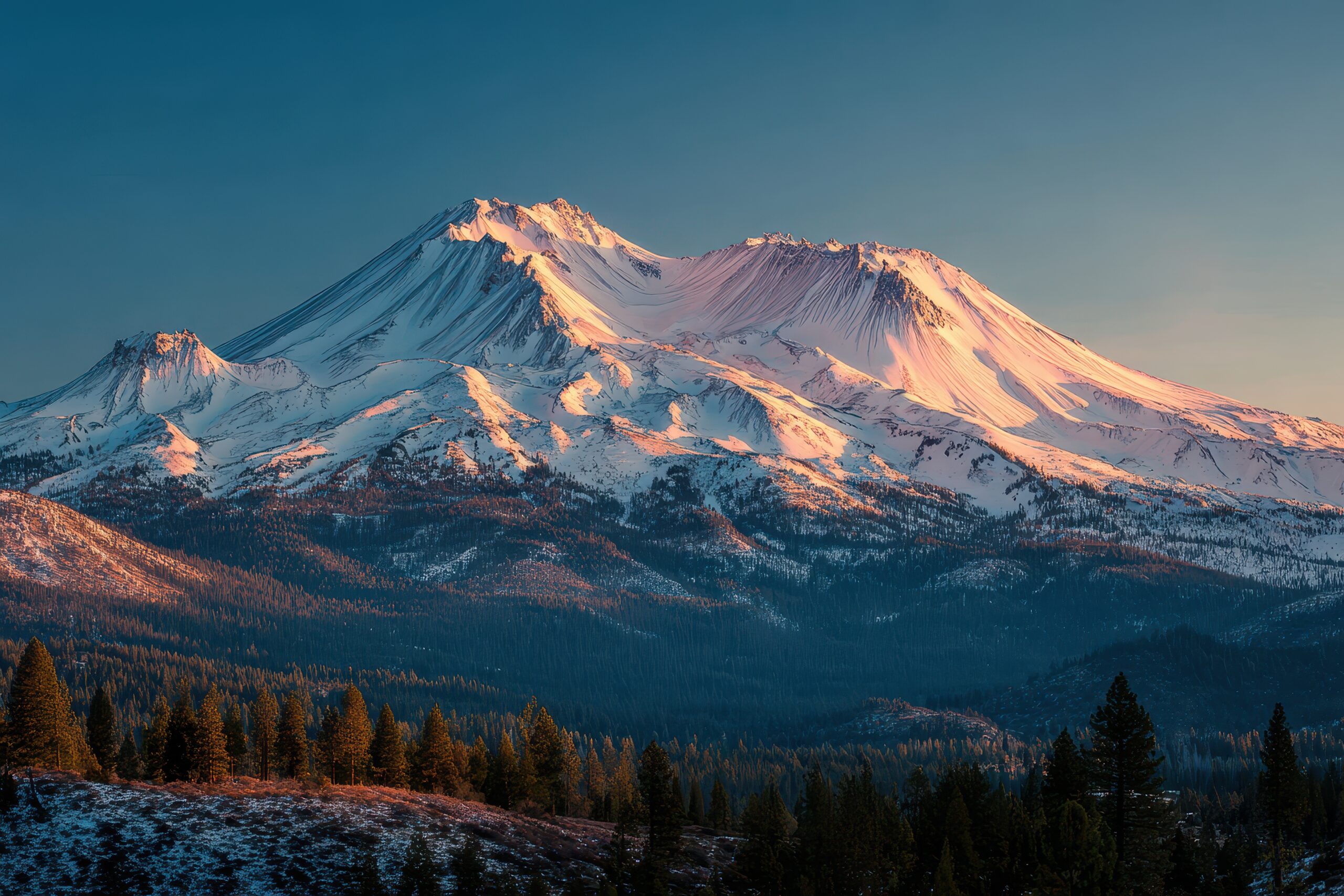
Mount Shasta rises 14,179 feet (4,322 meters) in the southern Cascade Range of northern California, approximately 110 km / 70 miles south of the Oregon border. It is the fifth-highest peak in California and one of the most prominent volcanoes in the Cascade Range — second only to Mount Rainier in total volcanic mass among Cascade peaks. The mountain’s remarkable 3,000 m / 9,800 ft topographic prominence makes it visible from up to 225 km / 140 miles away under clear conditions, dominating the regional skyline of northern California and the southern Oregon foothills.
Mount Shasta is classified as a potentially active stratovolcano. Its most recent confirmed eruption occurred approximately 1786 — within historical memory by some Indigenous accounts but before formal European-American documentation. The mountain consists of four primary overlapping cones: Sargents Ridge, Misery Hill, Shastina (3,758m / 12,330 ft, the satellite peak on the western flank), and the modern Shasta main cone. Multiple smaller lava domes, fumaroles, and hot sulfur springs persist on the mountain’s flanks, evidence of continuing geothermal activity. The USGS classifies Mount Shasta as a “very high threat” volcano and monitors it continuously.
The Indigenous Sacred Mountain. Mount Shasta is sacred to multiple Indigenous peoples whose territories surround the mountain. The Winnemem Wintu call the mountain Bohem Puyuik — “Great Mountain” — and consider it their ancestral home; the Winnemem Wintu creation stories center on Mount Shasta and the McCloud River. The Shasta people (Shasta proper, distinct from the mountain name) call it Waka-nunee-Tuki-wuki. The Karuk call it Úytaahkoo (“White Mountain”). The Modoc, Klamath, Atsugewi, Achumawi, and other peoples have additional names and spiritual relationships with the mountain that span at least 9,000 years according to archaeological evidence.
Indigenous practices on Mount Shasta have historically included sacred ceremonies, vision quests, and pilgrimages. Several Indigenous accounts suggest pre-1854 ascents by tribal members; these were not formally documented in the Anglo-American historical record but should be acknowledged. The mountain’s sacred status continues today — the Winnemem Wintu Tribe, the Pit River Tribe, and other regional tribal communities maintain active spiritual and ceremonial relationships with the mountain. Climbers visiting Mount Shasta should be aware that they are on culturally significant Indigenous land and approach the mountain with appropriate respect. Several Indigenous-led organizations have publicly requested that climbers and tourists respect Indigenous protocols and not engage in activities (drone overflights, off-trail wandering, ceremonial appropriation) that conflict with traditional practices.
14 August 1854: The Elias Pearce First Ascent
The first verified European-American ascent of Mount Shasta was made on 14 August 1854 by Elias Pearce — an English pioneer settler who had come to northern California during the Gold Rush — leading a small party from the gold-rush town of Yreka, approximately 65 km / 40 miles north of the mountain. Pearce’s party climbed via what is essentially the modern Avalanche Gulch route from the south side of the mountain.
The 1854 ascent occurred at an interesting moment in northern California history. The Gold Rush (1848-1855) had brought tens of thousands of settlers to the region; Yreka was a booming mining town; California had been admitted to the United States as the 31st state in 1850. The Mount Shasta ascent reflected the typical European-American settler-explorer pattern of the period: ascending prominent peaks as demonstration of regional knowledge and frontier mastery. Pearce’s climb was widely reported in northern California newspapers and contributed to growing public interest in the mountain.
The Indigenous reaction to the 1854 ascent is incompletely documented but appears to have been significantly negative — the Winnemem Wintu and other regional tribes had considered the upper mountain sacred and not appropriate for casual visiting. The 1854 climb is one of multiple incidents in 19th-century California where European-American activities on sacred Indigenous sites caused continuing cultural tensions that persist to the modern day.
April 1875: John Muir’s Storm Survival
Through the 1860s-1880s, Mount Shasta became a popular climbing objective for the burgeoning California outdoor community. The famous Scottish-American naturalist John Muir climbed Mount Shasta multiple times — most notably in April 1875, when he was caught in a sudden storm near the summit and survived the night by sheltering in a hot sulfur fumarole at approximately 14,000 feet. Muir lay flat in the mud at the edge of the fumarole, alternately scalded by the geothermal heat below and freezing in the storm above. His account of the survival incident — published in the influential Steep Trails (1918) — became one of the iconic Mount Shasta stories and contributed to the mountain’s literary reputation.
Muir’s writings established several themes that continue today: the mountain’s remarkable geothermal activity (the fumaroles that saved him), its sudden weather changes, the spiritual significance of the high mountain experience, and the broader Cascade conservation imperative. Muir was instrumental in advocating for the protection of California’s mountain landscapes, eventually founding the Sierra Club in 1892.
1888: The First Sisson Hut at Horse Camp
In 1888, the first Sisson hut was constructed at Horse Camp (7,900 ft / 2,408m) on the south side of Mount Shasta. The hut was named after Justin Sisson (1825-1893), a local pioneer who had founded the nearby town of Sisson (now called Mount Shasta city) and operated stage routes and infrastructure that made mountain access possible. The original Sisson hut provided basic shelter for climbing parties; multiple replacement structures were built over subsequent decades. The modern Sierra Club Shasta Alpine Lodge at Horse Camp — built in 1923 and renovated multiple times — sits on the same site and continues to serve climbers today, providing the original spring water source (“Sisson Spring”) that has been the standard high-mountain water for over 135 years.
1920s-1950s: Sierra Club Era and Route Development
The Sierra Club became the dominant force in Mount Shasta climbing through the 1920s-1950s. The club operated the Horse Camp hut, organized annual climbs that brought hundreds of climbers up the mountain each spring, and established Mount Shasta as the standard California snow-climbing training peak. The 1940s saw the establishment of additional routes including Hotlum-Bolam Ridge (the major north-side route) and Casaval Ridge (a technical south-side alternative). The Whitney Glacier and Bolam Glacier on the north side became recognized as major California glacier-climbing objectives — though substantially smaller than the Mount Rainier glaciers.
1960s-1980s: The New Age Movement and Spiritual Tourism
Beginning in the 1960s and accelerating through the 1980s, Mount Shasta became a focal point of the American New Age spiritual movement. Various New Age communities claimed the mountain harbored a secret underground city of “Lemurians” (descendants of a lost Pacific civilization), that it contained portals to other dimensions, that it housed ascended spiritual masters, and that it was a major energy vortex similar to Sedona, Arizona. The 1987 Harmonic Convergence — a major New Age gathering — drew thousands of spiritual tourists to Mount Shasta, cementing its modern reputation as a spiritual destination.
The town of Mount Shasta city (renamed from “Sisson” in 1922) developed a substantial spiritual tourism economy alongside its climbing infrastructure. Visitors today can find crystal shops, channeling sessions, vision quest organizers, and a wide range of metaphysical services in town. The Indigenous community has expressed concerns about appropriation of sacred sites and ceremonies by New Age practitioners; this remains an ongoing cultural tension. For climbers, the New Age presence is generally peripheral to the climbing experience, though the town’s unique atmosphere distinguishes Mount Shasta from typical mountain climbing destinations.
1984: Mount Shasta Wilderness Designated
The Mount Shasta Wilderness was designated under the California Wilderness Act of 1984, signed by President Reagan. The 38,200-acre / 154 km² protected area includes the upper mountain above approximately 8,000 ft elevation and most of the standard climbing routes. The wilderness designation provided permanent legal protection from logging, mining, and motorized recreation. The Mount Shasta Wilderness operates under standard federal Wilderness regulations including the human waste pack-out rule, group size limits, and prohibitions on permanent structures.
2020s-2025: Climate Change and Glacier Retreat
Mount Shasta’s glaciers have retreated substantially over the past two decades. The Whitney Glacier, Bolam Glacier, Hotlum Glacier, and Wintun Glacier have all lost significant area and volume since 2000. Mount Shasta’s relatively southern latitude (41.4°N) and the long-term California drought patterns have produced particularly visible glacial changes — by some estimates, the Whitney Glacier has lost 30-40% of its 2000 area. Climbing route conditions have shifted accordingly, with greater rockfall hazard on previously stable terrain and earlier-season degradation of route conditions.
The 2025 climbing season demonstrated these trends. Substantial road damage closed multiple north-side and east-side trailheads (Clear Creek, Brewer Creek, North Gate, Old Ski Bowl all closed; Bolam access washed out). Climbing concentration on the south-side Bunny Flat trailhead increased significantly. Two notable 2025 rescue incidents — a March skier injury at 10,000 ft on Avalanche Gulch and an August solo-climber glissade fall near 13,000 ft — illustrated how quickly descent errors become serious on the mountain’s steep snow slopes.
The California Cascade Anchor — Why Mount Shasta Completes the Cascade Progression
Mount Shasta occupies a specific and valuable position in American Cascade Volcanoes climbing: it is the southernmost major Cascade volcano and the natural southern bookend of the Cascade progression that runs from Washington’s Mount Baker (10,781 ft) and Mount Rainier (14,410 ft) in the north, through Mount Hood (11,250 ft) and Mount Adams (12,281 ft) in Oregon and southern Washington, down to Mount Shasta (14,179 ft) at the southern end of the chain. Each peak has a distinct climbing character; Mount Shasta closes the cluster with the most accessible major Cascade volcano in California.
What makes Mount Shasta structurally distinct from the other Cascade Volcanoes:
- The most affordable major Cascade climb. Guided 2-3 day Mount Shasta programs cost $650-$1,400 — substantially less than guided Rainier ($1,650-$2,200) or Denali ($8,000-$10,000) programs. Forest Service fees ($25 Summit Pass + free wilderness permit) are minimal compared to NPS climbing fees. The mountain is the natural budget-conscious major California climb.
- The most snow-climbing-focused Cascade peak. Unlike Mount Rainier’s heavy glaciation or Mount Hood’s relative compactness, Mount Shasta’s standard Avalanche Gulch route is essentially a sustained snow climb on open gully slopes. The route teaches snow movement, self-arrest, and snow-camping at altitude in a way that translates directly to harder Cascade objectives.
- The southernmost serious snow climb in the contiguous US. Mount Shasta’s latitude (41.4°N) makes it the southernmost major American snow-climbing destination. California climbers can access it without Pacific Northwest travel; spring snow conditions are accessible from late April through July before the route melts out.
- The “Cascade volcano without complications” peak. No permit lottery (unlike Whitney). No major glaciation requiring crevasse rescue training (unlike Rainier). No technical icefall sections (unlike Hood’s standard route). Just a sustained, demanding, accessible snow climb on a beautiful mountain.
- The complex spiritual context. The Indigenous sacred mountain status and the New Age tourism phenomenon make Mount Shasta culturally distinct from any other major US peak. Climbers should approach the mountain with awareness of these contexts.
As progression toward harder Cascade peaks: The standard American Cascade progression typically runs Mount Hood → Mount Baker / Mount Adams → Mount Shasta → Mount Rainier → Denali. Mount Shasta is the natural mid-progression peak — a step up from Hood, Baker, or Adams in elevation gain, and excellent preparation for Rainier’s glaciated complexity. Climbers building toward Denali, Aconcagua, or international expeditions often climb both Shasta and Rainier in the same season for combined snow and glacier preparation.
For climbers building a California-specific portfolio: Mount Shasta + Mount Whitney is the natural California 14,000-foot pair. Whitney provides the high-altitude hike experience (and the 22-mile distance test); Shasta provides the snow-climbing experience. Together they represent the two complementary “California 14er” experiences without the substantial expense of guided Sierra technical climbs.
Mount Shasta Historical Timeline
Archaeological evidence places the Winnemem Wintu, Shasta, Karuk, Modoc, Klamath, Atsugewi, Achumawi, and other Indigenous peoples in the Mount Shasta region for at least 9,000 years. The mountain — called Bohem Puyuik (“Great Mountain”) by the Winnemem Wintu — is sacred to multiple regional tribes.
Mount Shasta’s most recent confirmed eruption occurs approximately 1786 — within historical memory by some Indigenous accounts but before formal European-American documentation. The USGS classifies the mountain as “very high threat” with continuing monitoring.
Englishman Elias Pearce leads a small party from the gold-rush town of Yreka up what is essentially the modern Avalanche Gulch route. First documented European-American ascent. Several Indigenous accounts suggest pre-1854 tribal ascents that were not formally documented.
John Muir is caught in a sudden storm near the summit and survives the night sheltering in a hot sulfur fumarole at approximately 14,000 ft. His account in Steep Trails (1918) becomes one of the iconic Mount Shasta stories and establishes the mountain’s literary reputation.
The first Sisson hut is constructed at Horse Camp (7,900 ft) on the south side. Named after Justin Sisson, founder of the nearby town. The modern Sierra Club Shasta Alpine Lodge — built 1923 — sits on the same site and uses the original Sisson Spring for water.
John Muir founds the Sierra Club partly inspired by his Mount Shasta experiences. The Sierra Club becomes the dominant force in Mount Shasta climbing through the 1920s-1950s, operating the Horse Camp hut and organizing annual climbs.
The town of Sisson (founded 1880s by Justin Sisson) is renamed to “Mount Shasta” to capitalize on the mountain’s growing climbing tourism. The town becomes the dominant service center for Mount Shasta climbing and the eventual New Age spiritual tourism economy.
The Sierra Club builds the modern Shasta Alpine Lodge at Horse Camp — the structure that continues to serve climbers today. Provides emergency shelter, basic services, and the famous Sisson Spring water source.
The 1940s see the establishment of Hotlum-Bolam Ridge (the major north-side route), Casaval Ridge (technical south-side alternative), and the Whitney Glacier and Bolam Glacier as recognized glacier climbing objectives. Mount Shasta becomes a multi-route mountain rather than a single-route peak.
Mount Shasta begins to attract New Age spiritual communities with claims about Lemurian underground cities, energy vortices, and ascended masters. The town of Mount Shasta city develops a substantial metaphysical tourism economy alongside its climbing infrastructure.
The Mount Shasta Wilderness is designated under the California Wilderness Act of 1984. The 38,200-acre / 154 km² protected area includes the upper mountain above approximately 8,000 ft elevation. Federal Wilderness regulations apply including human waste pack-out and no permanent structures.
The Harmonic Convergence — a major New Age gathering on August 16-17, 1987 — draws thousands of spiritual tourists to Mount Shasta. Cements the mountain’s modern reputation as a major American spiritual destination alongside Sedona, Arizona. Indigenous concerns about appropriation begin to receive wider attention.
Mount Shasta’s glaciers (Whitney, Bolam, Hotlum, Wintun) retreat substantially. The Whitney Glacier loses an estimated 30-40% of its 2000 area. Climbing route conditions shift; previously stable rock terrain becomes more rockfall-prone as ice retreats.
An experienced skier suffers a serious leg injury during descent around 10,000 ft on Avalanche Gulch. Rescue operation succeeds but illustrates the steep-snow descent hazard on the standard route.
A solo climber loses control while glissading near 13,000 ft, tumbles several hundred feet, and requires rescue. Second major 2025 incident on the standard route. Continues the “descent errors become rescue operations very quickly” pattern.
Multiple north-side and east-side trailheads (Clear Creek, Brewer Creek, North Gate, Old Ski Bowl) closed for the season due to road damage; Bolam trailhead road washed out. Climbing concentration on south-side Bunny Flat increases substantially. Shasta Skimo ski-mountaineering race continues.
The Mount Shasta Routes
Mount Shasta has more than 10 named climbing routes. The Avalanche Gulch route from the south side accounts for the substantial majority of summit ascents; Hotlum-Bolam Ridge from the north side is the second-most-climbed route when access is available.
| Route | Side | Style | First Ascent | Status |
|---|---|---|---|---|
| Avalanche Gulch | South | Steep snow (in season) | 14 Aug 1854 (Pearce) | ● Open · Standard · ~85% of ascents |
| Hotlum-Bolam Ridge | North | Glaciated snow + scrambling | 1940s | ● 2025: Limited Access (road washout) |
| Casaval Ridge | South | Technical mixed (snow/rock) | 1940s | ● Open · Technical Alternative |
| Clear Creek | South-East | Hike + scree (late season) | Various 1900s | ● 2025: Trailhead Closed |
| Hotlum Glacier | NE | Glaciated mountaineering | 1940s-1950s | ● Open · Experienced Glacier Climbers |
| Whitney Glacier | NW (between Shasta & Shastina) | Glaciated mountaineering | Various | ● Open · Experienced Glacier Climbers |
| West Face Variants | West | Steep snow / mixed | Various | ● Open · Experienced Climbers |
Avalanche Gulch — The Standard Route (Pearce’s 1854 Line)
Style: Sustained steep snow climbing in season; non-technical in good snow conditions, substantially more serious as snow melts out · Used by ~85% of climbers.
Trailhead: Bunny Flat (7,000 ft / 2,134m), 14 miles east of Mount Shasta city via Everitt Memorial Highway. Large parking lot, restrooms, self-issue permit station. Open year-round.
Approach (Day 1): From Bunny Flat, hike approximately 2-3 miles to Horse Camp at 7,900 ft / 2,408m — site of the Sierra Club Shasta Alpine Lodge and Sisson Spring water source. Continue climbing to Helen Lake at 10,400 ft / 3,170m — the standard high camp. The Helen Lake bench provides flat camping sites and excellent views of the upper mountain. Most climbers stage here for Day 2.
Day 2 — Summit Push: Pre-dawn alpine start at 2-3 AM. From Helen Lake:
- Helen Lake (10,400 ft) → Red Banks (12,800 ft): The main Avalanche Gulch climbing section. Sustained steep snow on the open gully — typically 30-40° slope angle. Approximately 2,400 vertical feet of snow climbing. Crampons mandatory. Self-arrest skills essential. ~3-4 hours.
- Red Banks (12,800 ft): The crux landmark — a band of red volcanic rock that climbers traverse via a chute or chimney. Some teams ascend through the “Heart” (a notch in the Red Banks) which provides easier passage in most snow conditions.
- Misery Hill (12,800 → 13,800 ft): The notorious upper section — a steep, sustained slope of loose volcanic ash and snow that climbers ascend through deteriorating-quality terrain. The mountain’s name for this section reflects what climbers experience here at altitude with fatigue. ~1-1.5 hours.
- Summit Plateau (13,800 → 14,179 ft): Final approach to the summit across the relatively flat summit area. Hot sulfur fumaroles are visible to the side — the same fumaroles where John Muir survived in 1875. ~30-45 minutes from the top of Misery Hill.
Times: 6-9 hours up from Helen Lake; 4-6 hours down. Total summit-day time: 10-15 hours from Helen Lake round-trip. Most climbers descend all the way to Bunny Flat after summiting; some teams spend a second night at Helen Lake before descending.
Glissading: The Avalanche Gulch gully is famous for glissading (controlled sliding) on the descent. Climbers can glissade approximately 2,000-3,000 vertical feet of snow in good conditions — turning a 4-6 hour descent into 1-2 hours. HOWEVER: the August 2025 fatal fall and multiple other incidents demonstrate glissading hazard — crampons must be removed (they catch and produce ankle/leg fractures), and climbers must have ice axe self-arrest competence. Loss of control on glissading at altitude is among the most common Mount Shasta accident patterns.
Used by: All major Mount Shasta guide operators (Shasta Mountain Guides, Sierra Wilderness Guides, Sierra Mountain Center, etc.). 85%+ of independent climbers as well.
Hotlum-Bolam Ridge — The Major North-Side Alternative
Style: Glaciated snow climbing with scrambling sections; significantly more remote and less crowded than Avalanche Gulch.
Trailhead: Originally North Gate trailhead (closed in 2025 season) or Bolam trailhead (road washed out in 2025). Currently limited access on this route due to 2025 trailhead closures.
Character: Ascends the northern ridge between the Hotlum and Bolam Glaciers. The route involves sustained snow climbing on the ridge, occasional crevasse hazard from the adjacent glaciers, and a significantly more remote experience than the busy Avalanche Gulch side. Camp typically at approximately 9,500-10,500 ft on the moraine.
Why climbers choose it: Less crowded — most Mount Shasta traffic stays on the south side. More glaciated mountaineering character. Better as preparation for harder glacier objectives like Rainier or Denali. Late-season conditions are typically better on the north side than on Avalanche Gulch.
The 2025 access issue: All major north-side trailheads were closed for the 2025 season due to road damage. Climbers wanting the Hotlum-Bolam experience had to use creative approaches via the south or check current Forest Service trailhead status. Climbers should verify current access before planning a Hotlum-Bolam attempt. Check forest service updates via Shasta-Trinity NF Current Conditions before assuming this route is available.
Casaval Ridge — The Technical South-Side Alternative
Style: Mixed snow + rock scrambling on the south-side ridge between Avalanche Gulch and Sargents Ridge.
Character: The Casaval Ridge — first climbed in the 1940s — provides a substantially more technical alternative to Avalanche Gulch from the same Bunny Flat trailhead. The route ascends the prominent ridge to the climber’s left of Avalanche Gulch, involving steeper snow climbing, occasional rock scrambling, and more sustained exposure than the standard route. Approximately Class 3-4 mixed terrain at the harder sections.
Why climbers choose it: A genuinely technical alternative for climbers wanting more than the Avalanche Gulch snow climb. Less crowded than the standard route. Often in better snow conditions than Avalanche Gulch as the season progresses. Provides good preparation for harder Sierra Nevada or international peaks.
The trade-off: Significantly more committed than Avalanche Gulch — retreat from the upper ridge is more difficult. Requires real scrambling competence and willingness to move on exposed terrain. Not recommended as a first Mount Shasta route; build through Avalanche Gulch first.
Permit: Same permits as Avalanche Gulch (Wilderness Permit + $25 Summit Pass). No separate permit category required.
Hotlum Glacier, Whitney Glacier & Other Routes
Hotlum Glacier: The northeast-side glacier, a significantly more committing climb than Hotlum-Bolam Ridge. Sustained 40-50° snow/ice climbing with crevasse hazard. Among the more serious California glacier climbs. Most ascents from a high camp around 9,500-10,500 ft on the moraine.
Whitney Glacier: The largest glacier on Mount Shasta — located between the main Shasta cone and Shastina (the satellite peak). Approximately 1.4 km long, providing a major California glacier-climbing objective. Whitney Glacier ascents are typically done as multi-day expeditions with camp on the moraine.
West Face / Cascade Gulch: Multiple snow-climbing alternatives on the west and northwest sides of the mountain. These routes vary substantially in difficulty by season and conditions. Casaval Ridge and the various West Face routes provide options for experienced climbers wanting alternatives to the standard south-side line.
Modern status: The Mount Shasta glacier routes are climbed by perhaps 200-500 parties per year combined (substantially less than Avalanche Gulch). All these routes require glacier travel competence including crevasse rescue. Climate change has visibly affected the glaciers — Whitney Glacier has lost 30-40% of its 2000 area, with similar retreat on the other glaciers. Conditions are typically best in early-mid summer before peak melt season.
The Avalanche Gulch Progression (Standard Route)
The standard Mount Shasta route progresses through these named locations from trailhead to summit:
Glissading is the most common Mount Shasta accident pattern. The Avalanche Gulch gully provides 2,000-3,000 vertical feet of glissadable snow on descent — turning a slow 4-6 hour descent into 1-2 hours of fast snow-sliding. However: the August 2025 solo-climber fall near 13,000 ft and multiple historical incidents document the hazard. Crampons MUST be removed (they catch and produce ankle/leg fractures), climbers MUST have ice axe self-arrest competence, slope angle MUST be appropriate (too steep produces uncontrolled acceleration). The standard rule: glissade only on slopes you would willingly down-climb if you couldn’t slide; if you can’t self-arrest within 5 seconds at peak speed, the slope is too steep. Multiple Mount Shasta deaths have resulted from glissading attempts that went wrong.
Costs & 2026 Logistics
Mount Shasta is the most affordable major Cascade volcano climb. No permit lottery, no commercial guide requirements, no expensive NPS climbing fees. The $25 Summit Pass + free Wilderness Permit are the entire federal cost. Guided programs are optional and significantly cheaper than equivalent Rainier or Denali programs.
| Item | Cost | Notes |
|---|---|---|
| Mount Shasta Wilderness Permit | $0 (free) | Required for all climbers; self-issue at trailhead or via Recreation.gov |
| Mount Shasta Summit Pass | $25 per climber | Required for travel above 10,000 ft; valid up to 3 days from purchase |
| Shasta-Trinity National Forest entrance | $0 | No federal entrance fee for the national forest |
| Sierra Club Horse Camp Hut donation | $5-$20 voluntary | Suggested donation to Sierra Club for hut maintenance; not required |
| Bunny Flat parking | $0 | Free parking at trailhead; lot fills early on peak weekends |
| Mount Shasta city lodging (per night) | $80-$200 | Best Western, Strawberry Valley Inn, Mount Shasta Resort, motels; book ahead in peak season |
| Shasta Mountain Guides 2-3 day program | $650-$1,000 | Local Mount Shasta operator; AMGA-certified guides; standard guided product |
| Sierra Wilderness Guides 2-3 day program | $700-$1,100 | Sierra-focused operator with Mount Shasta programs |
| Sierra Mountain Center 2-3 day program | $750-$1,200 | Bishop-based AMGA operator with Mount Shasta seasonal offerings |
| Premium programs (4-day with training) | $1,200-$1,800 | Includes mountaineering instruction; common for first-time snow climbers |
| Mount Shasta city gear rental (boots, axe, crampons) | $80-$200 | The Fifth Season Sports, Shasta Mountain Guides Shop, various outfitters |
| Travel from SF Bay Area | $50-$120 gas | 5-6 hours via Interstate 5 |
| Travel from LA | $100-$200 gas | 8-9 hours via Interstate 5 + US-101 |
| Independent climber budget (2-day) | $100-$300 | Permits + lodging + food + gas (assuming local gear ownership) |
| Guided climber budget (2-3 day program) | $700-$1,400 (USD) | Includes guide + group gear; gear rental + travel + lodging separate |
| Total trip budget (guided, including travel) | $1,200-$2,500 USD | Including travel, lodging, gear rental, contingency |
Why Mount Shasta is the most affordable major Cascade climb. Three structural reasons: (1) No commercial guiding monopoly — unlike Mount Rainier (restricted to RMI, Alpine Ascents, IMG concessioners), Mount Shasta allows multiple competing operators including local Shasta Mountain Guides and Sierra-based operators. Pricing competition keeps rates lower. (2) No permit quota — climbers don’t compete in a lottery; permits are unlimited. (3) Forest Service management rather than National Park — Forest Service climbing fees are substantially lower than NPS fees. The result: guided 2-3 day Mount Shasta climbs at $700-$1,400 are roughly 50% cheaper than equivalent Mount Rainier programs at $1,650-$2,200. As a “first major snow climb” or “Cascade volcano experience,” Mount Shasta offers the best value in American mountaineering.
The 2025 trailhead access issue continues into 2026. Multiple alternative trailheads (Clear Creek, Brewer Creek, North Gate, Old Ski Bowl) closed for the 2025 season due to road damage; Bolam trailhead road washed out. As of early 2026, these closures may continue — climbers planning north-side or east-side routes should verify trailhead status with the Shasta-Trinity National Forest (conditions page) before trip planning. South-side Bunny Flat and Sand Flat trailheads remain reliably open year-round. If planning Hotlum-Bolam, Whitney Glacier, or Clear Creek routes, confirm current access before committing.
Best Time to Climb & Cascade Weather
The Mount Shasta climbing season runs from late April through early July, with the prime guided window typically May through June. Conditions deteriorate dramatically through July-August as snow melts out on the south side; late-season climbers shift to north-side routes when accessible.
| Period | Window | Conditions | Watch For |
|---|---|---|---|
| Winter | December – Early April | Heavy snow on lower mountain; potential ski mountaineering; technical winter only | Avalanche hazard; storms; full winter alpine competence required |
| Early Season | Late April – May | Snow climbing conditions establishing; Helen Lake becoming accessible | Snow stability variable; some routes not yet ready; Bunny Flat road may have late-season closure |
| Prime Season | May – June | Best snow conditions on Avalanche Gulch; firm snow, continuous lines; ideal alpine character | Weekend crowding; Helen Lake camping pressure; afternoon thunderstorms developing |
| Mid-Season | July | Snow beginning to melt out; warmer temperatures; lower-mountain access easier | Increasing rockfall on Avalanche Gulch; rapidly deteriorating standard route quality |
| Late Season | August – September | South-side routes substantially deteriorated; rockfall hazard high; climbing shifts to north side | 2025 Aug 4 and Aug 24 rescues illustrate descent hazard pattern; very few summer guided programs |
| Off-Season | October – April | Winter conditions; ski mountaineering for experienced parties only | Avalanche hazard substantial; only well-equipped winter mountaineers |
The pre-dawn alpine start. Mount Shasta summit days typically begin at 2-3 AM from Helen Lake. The early start serves multiple purposes: (1) snow conditions in the Avalanche Gulch gully are firmer in pre-dawn cold, reducing slip hazard; (2) self-arrest is more reliable on firm snow; (3) afternoon thunderstorms in the Cascades are common in summer — climbers must summit and descend the upper slopes before lightning develops; (4) the long round-trip from Helen Lake requires most of the day. Climbers who start later than 4 AM almost always face elevated weather and snow-stability risk on the upper mountain.
The seasonal route transition matters more on Shasta than on most peaks. Mount Shasta is sometimes described as a “warm” snow climb because of its southern latitude. In practice, this means snow conditions degrade faster than on more northern Cascade peaks: by mid-July in typical years, the Avalanche Gulch route has lost most of its snow climbing character and becomes a tedious slog through loose volcanic ash and unstable rock. The same climbers who experienced firm-snow conditions on Avalanche Gulch in May find a substantially different (and substantially worse) mountain by August. Plan for the snow-climbing season; expect a different mountain in late season.
Essential Gear Checklist
Mount Shasta gear requirements are standard steep snow mountaineering kit — significantly less elaborate than Rainier (no rope team / glacier gear required on Avalanche Gulch) but substantially more than Whitney (full snow climbing kit required). The mountain is the natural “first snow climb” peak for many American mountaineers.
Snow Climbing Clothing
- Synthetic or merino base layers (top + bottom)
- Mid-weight insulating layer (fleece or synthetic)
- Lightweight down or synthetic insulated jacket
- Quality hardshell jacket + pants (Gore-Tex or equivalent)
- Warm beanie + buff + sun hat
- Liner gloves + insulated climbing gloves + summit mitts
- Glacier sunglasses (Category 4) + goggles for storms
Footwear & Crampons (Essential)
- Mountaineering boots B2 (semi-rigid): La Sportiva Trango, Scarpa Charmoz, Salewa Crow GTX
- Crampons with anti-balling plates (Petzl Vasak, Grivel G12, Black Diamond Sabretooth)
- Wool/synthetic socks (2-3 pairs) + liner socks
- Gaiters (calf-height; full snow coverage)
- Camp shoes for Helen Lake
Self-Arrest & Climbing Hardware
- Ice axe (60-65cm general-mountaineering axe — essential)
- Practice self-arrest BEFORE arriving at Mount Shasta
- Climbing helmet (essential — rockfall hazard above Red Banks)
- Climbing harness (lightweight; for emergency rope use)
- 2 locking carabiners + 2 standard carabiners
- Single 30m rope for emergency use (optional; not required)
- Trekking poles for approach (collapsible)
Camp & Personal Gear
- 40-50L technical alpine pack
- 4-season tent (with snow stakes for Helen Lake)
- Sleeping bag rated to -10°C/15°F or colder
- Sleeping pad (closed-cell foam + inflatable combo)
- Stove + fuel (for melting snow at Helen Lake)
- 1L+ insulated water bottle + electrolytes
- WAG bags (Waste Alleviation and Gelling — mandatory pack-out)
- Trail food + summit-day energy bars/gels
- Sunscreen (SPF 50+), lip balm with SPF
- Personal first aid kit + headlamp + spare batteries
- $25 Summit Pass + Wilderness Permit + ID
Difficulty & What Mount Shasta Actually Demands
Mount Shasta is sometimes described as “an easy hike” because of its non-technical reputation in good snow conditions. This description is misleading. The standard route requires sustained steep snow climbing, self-arrest competence, and substantial fitness for the 7,179 vertical feet of elevation gain. Five specific characteristics define what the mountain actually demands:
1. The Avalanche Gulch slope angle is sustained and serious. The 2,400 vertical feet of snow climbing between Helen Lake (10,400 ft) and Red Banks (12,800 ft) is sustained 30-40° snow — not steep by alpine ice-climbing standards but steep enough that climbers who slip and cannot self-arrest can slide 1,000+ feet on the open gully slopes. The Avalanche Gulch name is not coincidental — the route’s namesake hazard is real. Multiple Mount Shasta fatalities involve loss of control on Avalanche Gulch descent.
2. Self-arrest competence is genuinely required. Unlike Whitney (where slipping on the trail means landing on rocks) or hike-style peaks where the consequence is moderate, slipping on Avalanche Gulch means sliding hundreds of feet. Climbers without practiced self-arrest skills should not be on Avalanche Gulch. The skill takes 30-60 minutes to learn in basic form but should be practiced on lower-angle slopes (Mount Hood, Mount Baker, or weekend snow-climbing instruction) before attempting Mount Shasta. Many Mount Shasta guides include 1-2 hours of self-arrest practice on Day 1 specifically to ensure clients have the skill before the climb.
3. Rockfall is genuine — and increasing. Mount Shasta’s southern latitude and accelerating glacier retreat have produced substantially more rockfall on previously stable terrain. The Red Banks area is the principal rockfall zone — climbers ascend through and past loose volcanic rock cliffs where ice has historically held terrain in place. Helmets are mandatory. Climbers should monitor the slopes above them for rock activity and move quickly through known rockfall zones. Late season (July-August) rockfall on Avalanche Gulch is severe enough that experienced climbers and guides specifically avoid the route during these months.
4. Glissading produces more accidents than climbing. The August 2025 solo-climber fall near 13,000 ft and dozens of historical incidents document this pattern: more Mount Shasta accidents happen on descent (especially glissading) than on ascent. Glissading is tempting — the 2,000-3,000 vertical feet of glissadable snow turns a slow descent into a fast one — but requires specific technique: crampons removed, ice axe in correct self-arrest position, slope angle assessed, speed controlled. Climbers who haven’t practiced glissading on lower-angle slopes routinely lose control. If you can’t self-arrest within 5 seconds at peak speed, the slope is too steep to glissade.
5. The mountain rewards early starts; punishes late ones. 2-3 AM departures from Helen Lake exist because: (a) snow firmness in pre-dawn cold makes self-arrest reliable; (b) afternoon thunderstorms regularly produce lightning above 12,000 ft; (c) Misery Hill is more brutal in afternoon sun and warmer snow; (d) the long round trip needs the full daylight window. Climbers who sleep in past 4 AM compress these safety margins substantially. Trust the alpine start protocol — it’s not arbitrary. The early start is the single most important climbing decision on Mount Shasta.
What Mount Shasta rewards: Climbers with prior snow-climbing experience (Mount Hood, Mount Baker, smaller Cascade snow climbs, or formal mountaineering instruction), self-arrest competence (practiced beforehand on lower-angle slopes), comfort with sustained steep snow at altitude, fitness for 8-12 hour summit days, willingness to embrace the 2-3 AM start time, awareness of the seasonal route transition (best in May-June, deteriorating after July), and acceptance of the Indigenous sacred-mountain context. As preparation for Mount Rainier, the Cascade Volcanoes progression, or international snow expeditions, Mount Shasta is excellent — it teaches the operational pattern that translates directly. As a standalone “California 14er”, the mountain delivers a genuine snow-climbing summit at low cost. As preparation for Aconcagua or Himalayan expeditions, the altitude and endurance experience transfer; the snow-climbing skills do not directly transfer to rock+ice peaks. Mount Shasta is the natural mid-progression peak — harder than Hood, easier than Rainier, accessible by car from most of California.
Featured Expedition Operators
Mount Shasta has the most diverse commercial guiding scene of any major Cascade volcano — multiple competing operators rather than the three-concessioner monopoly at Mount Rainier. Below are the established operators running Mount Shasta programs in 2026.
Shasta Mountain Guides
The dominant local operator based in Mount Shasta city. AMGA-certified guides with substantial Mount Shasta-specific knowledge. Offers 2-3 day Avalanche Gulch programs, ski mountaineering programs, glacier-side technical climbs, and the standard “first major snow climb” instructional product. The natural operator choice for climbers wanting local expertise. shastaguides.com
Sierra Wilderness Guides
Northern California-based operator offering Mount Shasta programs alongside Sierra Nevada and Eastern California climbs. AMGA-certified guides; strong reputation for thorough client preparation. Often packaged with Mount Whitney or other Sierra peaks for California climbing portfolios. sierrawilderness.com
Sierra Mountain Center
Bishop, California-based operator with AMGA-certified guides. Offers Mount Shasta as part of a broader Sierra Nevada and Cascades program portfolio. Strong for clients building toward Rainier, Denali, or international expeditions through formal progression peak programming. sierramountaincenter.com
Alpine Skills International (ASI)
Truckee-based operator with structured Mount Shasta programs and mountaineering courses. AMGA-certified. Often combines Mount Shasta with avalanche education or technical snow climbing instruction. Good fit for clients wanting more formal alpine education alongside the climb. alpineskills.com
Mountain Madness
Seattle-based operator with occasional Mount Shasta programs as part of Cascade Volcanoes progression. Often packaged with Rainier or Baker for combined-peak climbers. Founded by Scott Fischer in 1984; continues operating with strong Pacific Northwest mountaineering reputation. mountainmadness.com
RMI Expeditions (Occasional)
The famous Mount Rainier guide service (founded by Lou Whittaker in 1969) occasionally offers Mount Shasta programs as Sierra acclimatization for clients building toward Rainier or Denali. Programs are infrequent but high-quality when offered. rmiguides.com
Frequently Asked Questions
Mount Shasta rises to 4,322 meters (14,179 feet) in the southern Cascade Range of northern California. It is the fifth-highest peak in California and one of the most prominent volcanoes in the Cascade Range — second only to Mount Rainier in total volcanic mass. The mountain has a remarkable 3,000 m / 9,800 ft topographic prominence, making it visible from up to 225 km / 140 miles away under clear conditions. Mount Shasta is a potentially active stratovolcano — last erupted approximately 1786 — with multiple smaller cones, lava domes, and the satellite peak Shastina (3,758m) on its western flank.
The first verified ascent of Mount Shasta was made on 14 August 1854 by Elias Pearce — an Englishman and pioneer settler in northern California — leading a small party from the town of Yreka. Pearce climbed via what is essentially the modern Avalanche Gulch route. However, the mountain has been visited and is sacred to multiple Indigenous peoples — including the Winnemem Wintu, Shasta, Karuk, Modoc, Klamath, Atsugewi, and Achumawi — who maintained spiritual relationships with the mountain for thousands of years before Pearce’s 1854 climb. Several Indigenous accounts suggest pre-1854 ascents by tribal members; these were not formally documented in the Anglo-American historical record but should be acknowledged as predating European-American “first ascent” claims.
Avalanche Gulch is the standard route, accounting for the substantial majority of Mount Shasta ascents. Climbers approach from Bunny Flat trailhead (7,000 ft / 2,134m), 14 miles east of the town of Mount Shasta on the south side. The route ascends through Horse Camp (7,900 ft / 2,408m) — site of the historic 1888 Sisson hut — to Helen Lake (10,400 ft / 3,170m), the standard high camp. Day 2 ascends through Avalanche Gulch itself — a steep snow gully — past Red Banks (12,800 ft) and the Misery Hill section to the summit. Total elevation gain from Bunny Flat: 7,179 feet (2,188m). Total round-trip distance: approximately 11 miles / 17.7 km. The route is non-technical in good snow conditions but becomes substantially more serious in late season when rockfall and loose terrain dominate.
Yes — two separate permits are required to climb above 10,000 feet on Mount Shasta: (1) a free Wilderness Permit obtainable through self-issue at trailheads or via Recreation.gov; (2) a $25 Summit Pass required for any travel above 10,000 ft elevation, valid for up to 3 days from purchase. Both permits are required year-round. There is no quota or lottery system on Mount Shasta — permits are unlimited but mandatory. Climbers must self-issue at the trailhead or buy passes online before arrival. Recent 2025 access patterns saw substantial concentration on the south side (Bunny Flat and Sand Flat trailheads open) while alternate trailheads (Clear Creek, Brewer Creek, North Gate, Old Ski Bowl) remained closed and Bolam trailhead road access was unavailable due to washout damage.
Mount Shasta has caused approximately 130 climber and skier deaths since 1854, with annual death tolls averaging 1-3 per year. The mountain’s danger comes from a specific combination of factors: (1) steep sustained snow climbing on the standard Avalanche Gulch route — climbers who slip and cannot self-arrest can slide 1,000+ feet on the open gully slopes; (2) substantial rockfall hazard, particularly on late-season south-side routes after snow melts out; (3) lightning hazard on the exposed summit area; (4) altitude — 4,322m is high enough to produce significant AMS in unacclimatized climbers; (5) weather changes that can produce sudden severe storms. The March 2025 skier injury at 10,000 ft on Avalanche Gulch and the August 2025 solo climber fall near 13,000 ft both illustrated how quickly descent errors become serious.
Guided 2026 Mount Shasta climbs typically cost $650-$1,400 per climber for the standard 2-3 day program through major operators like Shasta Mountain Guides, Sierra Wilderness Guides, Sierra Mountain Center, or Alpine Skills International. The 2-3 day program includes guide, basic group gear, mountaineering instruction, and the summit attempt. Forest Service fees: $25 Summit Pass per climber (valid 3 days from purchase) plus the free wilderness permit. Independent climbers can budget $100-$200 for fees, permits, gas, and basic logistics. Total trip budget including travel to Mount Shasta city, gear rental, and weather contingency typically runs $1,200-$2,500 USD for guided climbers — making Mount Shasta the most affordable major Cascade volcano climb.
The main Mount Shasta climbing season runs from late April through early July, with the prime guided window typically May through June. This is the snow-climbing season when Avalanche Gulch is at its best — firm snow on the gully slopes, more continuous climbing lines, and classic alpine conditions. From mid-July onward, the standard south-side routes deteriorate substantially: snow melts out, rockfall hazard increases dramatically, and the climb becomes a tedious slog through loose volcanic rock and ash. By August-September, the south-side routes are generally considered unsafe due to rockfall, and climbers shift to the north-side routes (Hotlum-Bolam Ridge, Hotlum Glacier) when accessible. Spring conditions (March-April) require winter mountaineering skills and substantially elevated avalanche risk.
Mount Shasta is one of the more beginner-friendly major Cascade volcanoes — but it requires snow-climbing competence including self-arrest skills, comfort on sustained steep snow, and fitness for the 7,179 vertical feet of elevation gain. Climbers without prior snow-climbing experience should not attempt Mount Shasta independently — but guided 2-3 day programs through major operators include the necessary instruction. The 4-day premium programs (with formal mountaineering training included) are excellent for first-time snow climbers. Most operators include self-arrest practice on Day 1 specifically to ensure clients have the skill before the climb. Approach the mountain through formal instruction rather than as a casual hike.
Mount Shasta sits in the southern Cascade Range of northern California, approximately 110 km / 70 miles south of the Oregon border in Siskiyou County. Coordinates: 41.4099°N, 122.1949°W. The mountain is the centerpiece of the Shasta-Trinity National Forest. The main service town is Mount Shasta city, a small town of approximately 3,200 people located at the base of the mountain along Interstate 5. The standard climbing approach is from Bunny Flat trailhead, 14 miles east of Mount Shasta city on the south side of the mountain. The mountain is approximately 5-6 hours by car from San Francisco and 8-9 hours from Los Angeles. Mount Shasta is famously visible from substantial distances — up to 225 km / 140 miles away under clear conditions.
Mount Shasta Map & Mount Shasta City Weather
Mount Shasta summit coordinates: 41°24’36″N 122°11’42″W (41.4099°N, -122.1949°W). The map below shows the summit’s position in the southern Cascade Range. Live weather is shown for Mount Shasta city (3,540 ft / 1,079m) — the main service town. Summit conditions are typically 25-32°C colder than Mount Shasta city.