
Last updated May 29, 2026
Mount Shasta Summit Success Rate 2026: California’s Premier Glacier Training Peak — Why Spring Snow Conditions Define the 58 Percent Rate
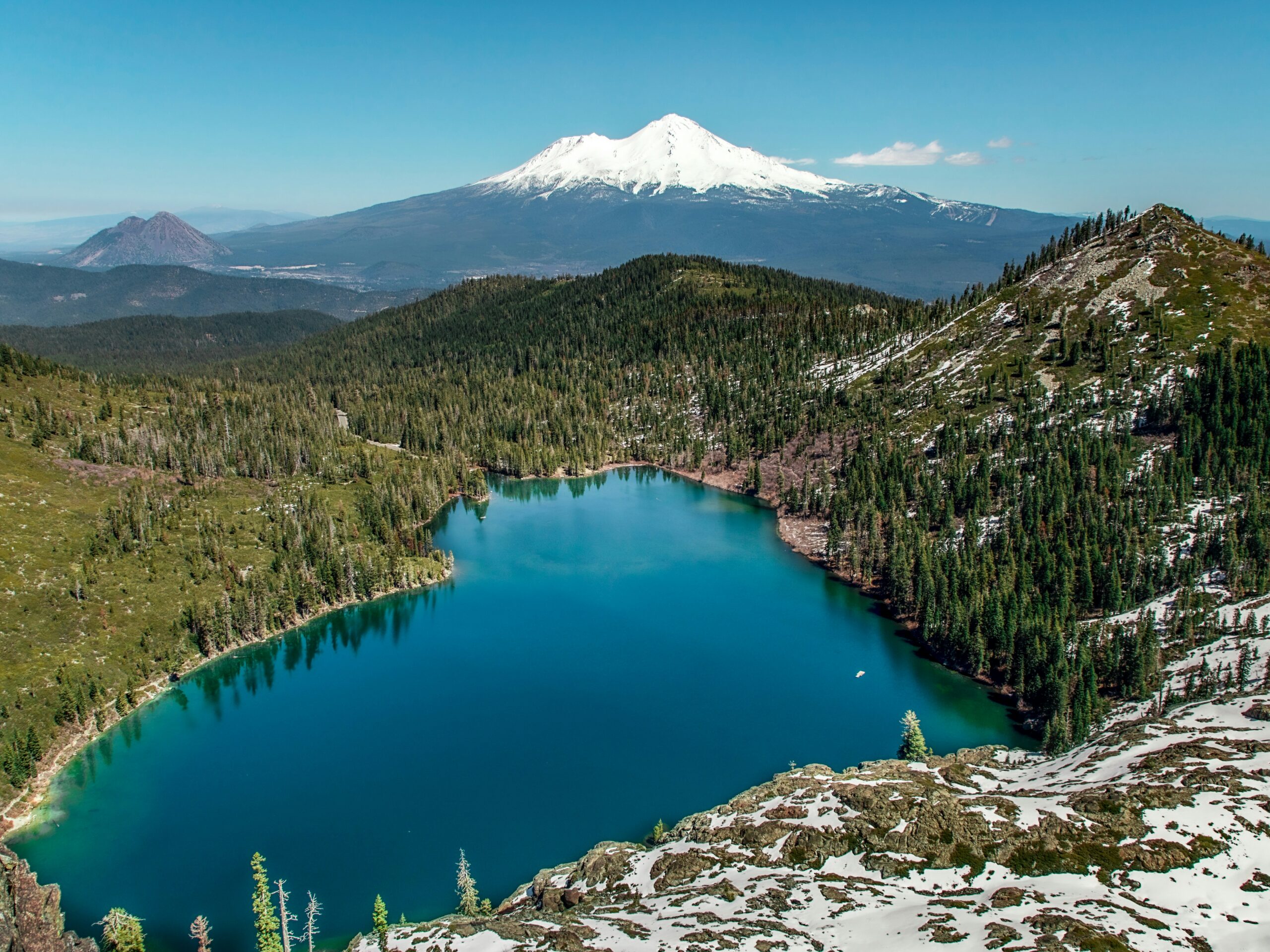
The dominant volcanic peak of northern California and one of the most-climbed glaciated mountains in North America. Generally, Shasta’s 58 percent overall success rate reflects an accessible and popular peak. The primary variables are Sierra Nevada weather unpredictability, altitude gain from the trailhead, and the physical demands of the long summit day on Avalanche Gulch. Specifically, the May-June spring snow window produces the year’s best conditions. Notably, by late July the route transitions from glacier climb to rockfall gauntlet.
California’s Premier Glacier Training Ground
Mount Shasta occupies a unique position in North American mountaineering. Generally, Shasta plays three roles at once. The most accessible serious glaciated peak in California. The primary training ground for climbers preparing for Rainier and Denali. And a mountain that generates more rescues per capita than almost any other peak in the western United States. Specifically, its 58 percent success rate reflects the tension between accessibility and genuine alpine hazards. Notably, the mountain combines three demanding factors. Weather that changes faster than any other California peak. Altitude gain that surprises climbers from sea level. And a summit day long enough to test cardiovascular fitness seriously.
The spring-snow-to-summer-rockfall transition is the structural feature that distinguishes Mount Shasta from most other Cascade volcanoes. Generally, May and June are when Shasta is at its most cooperative. Winter snowpack is still consolidated, weather is most stable, and Avalanche Gulch is a true glacier climb. Specifically, by late July the standard route transitions to loose volcanic rock that generates significant rockfall hazard. Notably, this seasonal character change is more pronounced than on Rainier or Mount Baker, where snowpack persists longer into summer.
How to read these numbers. Success is defined as reaching the true summit (4,322m). Generally, data covers all USFS summit zone permit holders 2005-2025. Specifically, independent climbing is fully permitted on all routes. Notably, the guided rate reflects commercial guiding programs while independent climbers represent the majority of permit holders on Avalanche Gulch. Winter season (November-March) attempts are limited to highly experienced mountaineers and excluded from these averages.
Find Hotels, Flights & Trips for the World’s Best Hiking Destinations
The Global Summit Guide Travel Shop on Expedia — curated for outdoor adventurers, mountaineers, and serious hikers. Patagonia to the Alps. Nepal to the Rockies. Curated lodging for every region we cover.
Explore Travel Shop on Expedia →The Headline Mount Shasta Numbers
| Metric | Rate | Notes |
|---|---|---|
| Overall summit success rate | ~58% | All routes, all months; USFS-permitted attempts 2005-2025 |
| Commercial guided success rate | ~74% | Avalanche Gulch predominantly; 26-point gap reflects weather judgment and turnaround discipline |
| Independent success rate | ~48% | Self-organised teams; summit fever is the dominant failure mode |
| Avalanche Gulch (Standard) | ~61% | Standard route; approximately 80% of all permitted attempts; 2-day ascent typical |
| Casaval Ridge | ~55% | Scenic west-side alternative; more technical mixed terrain; less traffic |
| North Face / Whitney Glacier | ~42% | Technical north and west routes; crevasse navigation required; experienced alpinists only |
| Prior Rainier or higher cohort | ~82% | Best-performing experience tier; glacier skills and summit-day endurance well established |
| Rescue incident rate | 1 in 65 | Per season; Siskiyou County SAR; most rescue callouts of any California peak |
| Fatality rate | 1 in 380 | Among all permit holders; moderate by mountaineering standards |
| 2026 expedition cost (all-in) | $25-$1,200 | Independent floor (USFS permit) vs guided ceiling for 2-3 day ascent |
Success Rate by Month
May and June are Mount Shasta’s statistical peak. Generally, this is the window when winter snowpack is still consolidated for efficient crampon travel on Avalanche Gulch. Specifically, weather patterns are most stable and summit-day conditions most reliable in late spring. Notably, July through September sees deteriorating snow conditions on the lower mountain and increased rockfall as the snowpack recedes.
| Month | Success Rate | Conditions |
|---|---|---|
| April | ~52% | Early season; Bunny Flat road may still be closed; experienced winter cohort favoured |
| May | ~64% | Statistical peak begins; consolidated snowpack; Bunny Flat typically opens; stable weather |
| June | ~68% | Peak window; longer daylight for extended summit days; firm snow; best overall conditions |
| July | ~56% | Snow conditions deteriorating; rockfall beginning; afternoon thunderstorms more frequent |
| August | ~48% | Avalanche Gulch transitions to loose rock; rockfall hazard significant; thunderstorm risk peaks |
| September | ~50% | Diminishing snowpack exposes more rock; cooler temperatures help but conditions degraded |
| October | ~42% | Late season; technical rock sections dominant; not recommended for first attempts |
The May and June window is when Shasta is at its most cooperative. Generally, June offers a particularly good combination of accessible roads (Bunny Flat typically opens in May), solid snowpack, and longer daylight for extended summit days. Specifically, by late July the Avalanche Gulch route transitions from snow to a loose rockfall-prone gully on its lower sections. Notably, this transition makes summer Shasta meaningfully less enjoyable and more hazardous than spring conditions. The structural change is one the headline 58 percent rate does not capture.
The spring snow window. Generally, the optimal Mount Shasta climb books a Memorial Day to mid-June window. Specifically, this captures the consolidated spring snowpack while extending daylight enough for comfortable summit-day timing. Notably, the trade-off is crowds — Memorial Day weekend is the busiest single weekend on the mountain. Climbers prioritising solitude over peak conditions should target mid-to-late June or early July. Climbers prioritising the best snow conditions should accept the crowds and book May or early June.
Success Rate by Route
Mount Shasta has several established routes with meaningfully different character. Generally, Avalanche Gulch is the standard and by far the most popular. Specifically, the technical routes on the north and west sides attract experienced alpinists and have meaningfully lower success rates. The pattern reflects both objective difficulty and the self-selection of experienced climbers who choose them. Notably, route choice matters more on Shasta than on most peaks because of the spring-to-summer character change on the standard line.
The Avalanche Gulch 61 percent rate is the most statistically significant in the database for this peak. Generally, the route sees thousands of attempts per year. Specifically, the crux is the final headwall from Helen Lake to the summit. The steep section known as The Heart and the exposed ridge above Misery Hill become particularly serious in deteriorating weather conditions. Notably, this section is at the limit for many first-time alpine climbers without prior steep-snow experience. Proper crampon and ice axe technique is essential rather than optional.
The summer rockfall transition. Generally, by late July the Avalanche Gulch route undergoes a structural character change. Specifically, the snow-filled gully becomes a loose volcanic rock chute with significant rockfall hazard from parties above. Notably, this transition is more severe on Shasta than on most other Cascade volcanoes because Shasta’s southern aspect and lower latitude accelerate the snowpack recession. Summer Shasta carries meaningfully more rockfall risk than spring Shasta — climbers who can flex their schedule should always target the May-June window over July-August.
Guided vs Independent
The 26-point guided/independent gap on Shasta is driven primarily by weather judgment and summit discipline. Generally, most independent climbers who fail on Shasta do so because of poor turnaround decision-making. Specifically, they either push into deteriorating weather or underestimate the time required to summit safely and descend before afternoon weather develops. Notably, this is the same failure mode that drives the Rainier guided/independent gap — Cascade weather rewards conservative timing decisions and punishes optimistic ones.
| Factor | Commercial Guided | Independent |
|---|---|---|
| Summit success rate | ~74% | ~48% |
| Weather judgment | Guides with 50-100+ Shasta ascents | Climber-managed; variable accuracy |
| Turnaround time enforcement | Strict turnaround at 10am-noon | Self-managed; often compromised by summit fever |
| Route conditions knowledge | Updated after every climb | Self-researched via trip reports; often outdated |
| Self-arrest verification | Guide verifies and instructs at Helen Lake | USFS requires but does not verify; climber-responsible |
| USFS ranger weather briefing | Guide attends and integrates into plan | Climber-attended; integration variable |
| Gear provision | Operator typically includes crampons, ice axe, helmet | Climber-supplied or rented in Mount Shasta City |
| Typical 2026 cost (all-in) | $650-$1,200 (2-3 day ascent) | $25 USFS permit plus personal gear |
| Best for | First glacier climb; first steep snow ascent; CORSAR access | Experienced climbers with prior glaciated peak summits and current self-arrest skills |
The guided premium on Mount Shasta reflects three primary factors. Generally, the first is weather judgment — Shasta generates its own weather systems and intercepts Pacific fronts faster than any other California peak. Specifically, the second is strict turnaround time enforcement. Guides hold their teams to a 10am-noon turnaround regardless of summit proximity. Notably, the third is current route and snow condition knowledge that guides maintain through frequent ascents. Independent climbers rely on trip reports that may be days or weeks old in a rapidly changing snowpack environment.
Recommendation for first Mount Shasta attempts. Hire a guide for the first glacier climb. Generally, the cost differential ($625-$1,175) is small relative to the headline expedition cost (travel to Mount Shasta City, gear, time off work). Specifically, reputable 2026 operators include Shasta Mountain Guides, Sierra Wilderness Seminars, Alpine Skills International, and Mount Shasta Alpine Guides. Notably, see our Mount Shasta operators comparison for detailed evaluation criteria. For experienced climbers with prior glaciated peak summits, independent climbing is fully viable. The USFS permit is straightforward and the standard Avalanche Gulch route is well-documented in trip reports.
Success Rate by Experience Level
Mount Shasta’s experience data shows a clear gradient driven primarily by prior alpine experience rather than altitude exposure. Generally, the altitude (4,322m) is not extreme enough to create significant physiological barriers for most fit climbers. Specifically, the combination of steep snow, self-arrest requirement, and long summit day consistently reveals preparation gaps in first-time alpine climbers. Notably, the gap between cohorts is 50 percentage points — meaningful, but skill-driven rather than altitude-driven.
| Prior Experience | Success Rate | Why |
|---|---|---|
| First glacier or alpine peak — no crampon experience | 32% | USFS requires self-arrest competency but does not verify it; many first-time climbers arrive without having practised the skill; steep sections above Helen Lake expose this gap directly |
| Prior glacier day or winter alpine experience | 56% | A single prior glacier day dramatically improves crampon and self-arrest confidence; prior winter hiking provides cold management and pacing skills |
| Prior summit of another Cascade or Sierra peak | 68% | Cascade or Sierra peak experience is the most directly applicable preparation; Hood, Rainier base camp, or a prior guided Shasta provides realistic calibration |
| Prior Rainier or higher summit with glacier experience | 82% | Best-performing cohort; prior Rainier or higher glacier experience provides both technical skills and summit-day endurance calibration that make Shasta manageable |
Prior Cascade peak experience is the decisive technical factor on Mount Shasta. Generally, climbers with prior Rainier or higher glacier experience reach 82 percent — meaningfully higher than first-time alpine climbers at 32 percent. Specifically, the transferable skills are clear. Crampon and self-arrest confidence. Weather pattern recognition for Cascade volcanoes. And the multi-hour summit-day endurance that the long Avalanche Gulch push demands. Notably, the optimal Cascade volcano progression runs Mount Shasta first (the accessible introduction), then Mount Baker or Mount Hood, then Mount Rainier (Denali prep).
The self-arrest verification gap. Generally, the USFS requires self-arrest competency for Mount Shasta summit zone permits but cannot verify it. Specifically, many first-time alpine climbers arrive at Bunny Flat having never practised the skill. Notably, the steep sections above Helen Lake — particularly The Heart on Avalanche Gulch — expose this gap immediately and consequentially. The first-glacier cohort’s 32 percent success rate is driven heavily by this single skill gap. A single day at a snow climbing course or on a local snowy slope dramatically changes the Helen Lake headwall experience. This is not optional preparation on Shasta — it is the difference between a successful first glacier climb and a frightened retreat from the headwall.
Most Common Turnaround Reasons
Five dominant turnaround reasons account for nearly all failed Mount Shasta summits. The data comes from USFS Mount Shasta Ranger District incident records and Siskiyou County SAR reports covering 2010-2025 on the Avalanche Gulch route. Generally, weather is the single biggest factor by a meaningful margin. Specifically, the exhaustion-and-technical combination follows closely. Notably, each of the five turnaround reasons has prep-time interventions that meaningfully reduce its likelihood.
Weather — rapid Sierra Nevada storm development
Mount Shasta generates its own weather systems and intercepts Pacific storm fronts with very little warning. Storms can arrive from the Pacific within hours of clear forecasts. Afternoon thunderstorms in summer develop faster than on any comparable California peak and lightning on the exposed upper mountain is a life-threatening hazard. Mitigation: target the May-June window; depart Helen Lake by 3am for the most stable morning conditions; set a 10am-noon turnaround time before leaving Helen Lake.
Exhaustion — summit day underestimated
The Avalanche Gulch summit day from Helen Lake (3,292m) to summit (4,322m) and back is 8-12 hours of sustained effort. Many climbers, particularly those from sea level, arrive at Misery Hill plateau depleted and unable to continue to the true summit. Mitigation: train with sustained aerobic base; weighted pack hill repeats; target the fitness benchmark of climbing 1,500m at sea level in 6-8 hours before departure.
Technical difficulty — steep snow above Helen Lake
The headwall above Helen Lake reaches 35-40 degrees on Avalanche Gulch. In icy morning conditions, this section requires confident crampon and ice axe technique. Many independent climbers without prior steep snow experience find the section at or beyond their limit. Mitigation: complete a snow climbing course before the trip; practise self-arrest on local snowy slopes; consider a guided introductory day before independent attempts.
Rockfall — summer season Avalanche Gulch
As snowpack recedes through July and August, the Avalanche Gulch route transitions to loose volcanic rock that generates significant rockfall hazard from parties above. Summer Shasta carries more rockfall risk than spring conditions by a meaningful margin. Mitigation: climb in the May-June window when possible; wear a helmet at all times above Helen Lake; manage rope team spacing to reduce rockfall-from-above exposure.
Altitude illness (AMS)
AMS is less common than on higher peaks. The condition still appears among sea-level climbers who drive to Bunny Flat (2,100m) and camp at Helen Lake (3,292m) in a single day. The altitude gain from California coast to Helen Lake in 24 hours is a physiological shock for unacclimatised climbers. Mitigation: arrive in Mount Shasta City a day early; consider a Bunny Flat day hike to 2,800m before the climb; stay hydrated through the approach.
The 64 percent rule. Weather (36 percent) and exhaustion (28 percent) together account for 64 percent of all Mount Shasta turnarounds. Generally, both are addressable through prep-time and timing interventions. Specifically, the weather factor responds to the May-June window plus disciplined 10am turnaround times. Notably, the exhaustion factor responds to sustained aerobic training in the months before departure. Climbers who optimise across these two factors typically see individual success rates closer to the 82 percent prior-Rainier cohort baseline. The optimised rate runs well above the 58 percent overall mountain rate.
Rescue Incident Frequency
Mount Shasta has well-organised rescue coordination between the USFS rangers and Siskiyou County SAR. Generally, helicopter access to Avalanche Gulch is available in favourable conditions. Specifically, despite this infrastructure, Shasta consistently generates more rescue callouts per year than any other California peak. Notably, this is a direct function of its enormous permit volume and the proportion of underprepared independent climbers in that population. The pattern reflects volume rather than per-climber risk.
| Safety Metric | Rate | Notes |
|---|---|---|
| Assisted rescue rate | 1 in 65 climbers | Per season; Siskiyou County SAR plus USFS rangers; volume-driven not risk-driven |
| Fatality rate | 1 in 380 climbers | Among all permit holders; moderate by mountaineering standards |
| Average helicopter rescue cost | ~$12,000 | California has no legal rescue cost recovery requirement; not covered by standard health insurance |
| Most common rescue cause | Falls on steep sections above Helen Lake | Almost always among climbers without adequate self-arrest practice |
| Helicopter access | To Avalanche Gulch in favourable conditions | USFS-coordinated with Siskiyou County SAR; weather-dependent above Helen Lake |
| CORSAR card recommendation | $5 California SAR card | Strongly recommended supplement to mountaineering insurance |
Falls on the steep sections above Helen Lake are the primary serious incident type on Shasta. Generally, these are almost always among climbers without adequate self-arrest practice. Specifically, the same first-glacier cohort that succeeds at only 32 percent contributes disproportionately to rescue incidents. Notably, Shasta’s rescue rate is volume-driven rather than risk-driven. Experienced climbers face meaningfully lower per-attempt rescue probability than the headline 1 in 65 figure suggests. The rescue rate among guided climbers is roughly a third of the rate among first-time independent climbers.
Insurance and CORSAR card both essential. Generally, California has no legal requirement for rescue cost recovery. Helicopter evacuation costs average $12,000 and are not covered by standard health insurance for wilderness incidents. Specifically, several dedicated mountaineering insurance providers offer compliant Mount Shasta coverage. Options include Global Rescue, World Nomads Explorer Plus, the American Alpine Club (AAC) expedition policy, and Ripcord Travel Insurance. Notably, the California CORSAR card ($5 annually) is a strongly recommended supplement. The card documents that the climber paid into the SAR system, which can affect insurance disputes after a rescue. The combination of dedicated mountaineering insurance and CORSAR card is the standard recommendation for all Shasta climbers. See our mountaineering insurance comparison for the full breakdown.
Historical Success Rate Trend
Mount Shasta’s success rate has shown high year-to-year variance driven primarily by snowpack levels. Generally, low snowpack years expose rockfall on Avalanche Gulch and reduce snow quality on the technical sections. Specifically, high snowpack years produce excellent spring conditions but extend the technical difficulty later into summer. Notably, the overall trend is slightly downward, reflecting increased permit volumes bringing more underprepared climbers to the mountain alongside the snowpack-driven variability.
| Period | Rolling Avg Success Rate | Key Notes |
|---|---|---|
| 2005-2010 | ~62% | Baseline era; moderate snowpack variability; smaller permit cohort |
| 2011 | ~72% | Record snowpack — exceptional conditions; highest single-year rate in modern data set |
| 2013-2015 | ~51% | Drought years; diminished snowpack exposes rockfall earlier; lowest sustained rates |
| 2016-2020 | ~58% | Recovery period; mixed snowpack years; permit volume growth begins |
| 2021-2025 | ~57% | Current baseline; continued permit volume growth; climate variability continues |
The 2011 spike reflects record snowpack that produced exceptional spring conditions. Generally, this was the highest single-year success rate in the modern data set. Specifically, the 2013-2015 drought years produced the lowest rates as diminished snowpack exposed rockfall on Avalanche Gulch earlier in the season. Notably, California’s ongoing drought-and-flood climate volatility makes Shasta’s year-to-year success rate more weather-dependent than any other peak in this database at comparable altitude. Climbers planning Shasta attempts should check current snowpack levels via the California DWR snowpack database before finalising trip dates.
Mount Shasta Success Rate FAQ
What is the Mount Shasta summit success rate in 2026?
The Mount Shasta summit success rate in 2026 runs approximately 58 percent across all USFS summit zone permit holders 2005-2025. Commercial guided programs reach approximately 74 percent. Independent climbers reach 48 percent — a 26 percentage point gap driven primarily by weather judgment and turnaround discipline. The Avalanche Gulch standard route runs 61 percent, the Casaval Ridge runs 55 percent, and the technical North Face / Whitney Glacier runs 42 percent. The 58 percent headline reflects Sierra Nevada weather unpredictability and the spring-snow-to-summer-rockfall transition more than absolute technical difficulty. Shasta is the most accessible serious glaciated peak in California and a primary training ground for climbers preparing for Rainier and Denali.
Is Mount Shasta a good first glacier climb?
Yes, in the right month and with proper preparation. Mount Shasta is the most accessible serious glaciated peak in California. It is also one of the best first glacier climbs in North America when climbed in May or June. The Avalanche Gulch standard route presents 35-40 degree steep snow climbing that requires crampons, ice axe, and self-arrest competency but no technical climbing. First-time alpine climbers without prior crampon experience reach only 32 percent on Shasta — a meaningful warning. The realistic minimum prep is a snow-climbing course or a guided introductory day. With one prior glacier day, first-timers reach 56 percent. The optimal Cascade volcano progression is Mount Shasta in May-June, followed by Mount Baker or Mount Hood, then Mount Rainier.
Should I climb Mount Shasta guided or independently?
If this is your first glacier climb or first steep snow ascent, hire a guide. Commercial guided programs on Shasta succeed at 74 percent while independent climbers succeed at 48 percent — a 26 percentage point gap. The gap reflects three structural factors. Weather judgment from guides with 50-100+ Shasta ascents. Strict turnaround time enforcement. And current route and snow condition knowledge updated after every climb. Summit fever is the dominant independent failure mode on Shasta — disciplined turnaround decisions are the single most consequential summit-day variable. Guided programs cost $650-$1,200 all-in for a 2-3 day ascent while independent climbs cost approximately $25 (USFS permit) plus personal gear. For experienced glaciated-peak climbers, independent climbing is fully viable and saves $625-$1,175.
What month is best to climb Mount Shasta?
May and June. This is when winter snowpack is still consolidated for efficient crampon travel on Avalanche Gulch. Weather patterns are most stable and summit-day conditions most reliable. May success rates run approximately 64 percent and June reaches approximately 68 percent. By late July the Avalanche Gulch route transitions from snow to a loose rockfall-prone gully on its lower sections. The route becomes meaningfully less enjoyable and more hazardous than in spring snow conditions. July through September brings deteriorating snow conditions and increased rockfall. The May-June window is when Shasta is a true glacier climb. Later in the season it is increasingly a rockfall gauntlet with much lower success rates.
How dangerous is climbing Mount Shasta?
Mount Shasta has a moderate safety profile. The rescue rate runs approximately 1 in 65 climbers per season — driven largely by enormous permit volume and the proportion of underprepared independent climbers. The fatality rate runs approximately 1 in 380 climbers — moderate by mountaineering standards. Shasta consistently generates more rescue callouts per year than any other California peak — a direct function of permit volume rather than per-climber risk. Falls on the steep sections above Helen Lake are the primary serious incident type, almost always among climbers without adequate self-arrest practice. Average helicopter rescue cost runs approximately $12,000 and is not covered by standard health insurance for wilderness incidents. Dedicated mountaineering insurance or a CORSAR card is strongly recommended.
What is the biggest reason climbers fail on Mount Shasta?
Weather. Rapid Sierra Nevada storm development accounts for 36 percent of all Mount Shasta turnarounds — the dominant failure mode. Shasta generates its own weather systems and intercepts Pacific storm fronts with very little warning. Storms can arrive from the Pacific within hours of clear forecasts, and afternoon thunderstorms in summer develop faster than on any comparable California peak. Exhaustion from the underestimated summit day accounts for 28 percent of turnarounds. Technical difficulty on the steep snow above Helen Lake drives 22 percent. Summer rockfall on Avalanche Gulch causes 10 percent. Altitude illness accounts for 4 percent. The weather-and-exhaustion combination drives 64 percent of all failed summits. Both are addressable through May-June timing windows and conservative summit-day plans with firm turnaround times.
How does Mount Shasta compare to Mount Rainier?
Both are Cascade volcanoes with similar character, but Mount Rainier is a meaningfully bigger objective. Mount Shasta is 4,322m and Mount Rainier is 4,392m — almost the same altitude. Rainier is a longer expedition (2-3 day standard) on more heavily glaciated terrain with greater crevasse hazard. Shasta is typically a 2-day climb on simpler glacier terrain. Shasta’s 58 percent success rate is higher than Rainier’s 54 percent, reflecting Shasta’s simpler logistics rather than easier climbing. For most North American climbers, the optimal Cascade volcano progression is clear. Mount Shasta first (the accessible glacier introduction). Then Mount Baker or Mount Hood. Then Mount Rainier (the Denali preparation peak). See our Mount Rainier success rate page for full Rainier data.
How much altitude experience do I need for Mount Shasta?
Less than most climbers think — but more than the trailhead altitude suggests. Mount Shasta’s 4,322m summit is not extreme enough to create significant physiological barriers for most fit climbers. AMS accounts for only 4 percent of turnarounds — the lowest altitude-illness share of any peak above 4,000m in our database. The primary preparation gap is not altitude but technical. The steep snow above Helen Lake and the long summit day reveal the alpine skill and fitness gaps in climbers who arrive without prior alpine experience. Sea-level climbers who drive to Bunny Flat (2,100m) and camp at Helen Lake (3,292m) the same day can do this without significant AMS risk. They should arrive with prior crampon and self-arrest practice. The skill gap matters more than the altitude gap on Shasta.
Sources and Methodology
Data Sources
This page aggregates data across the following authoritative sources:
- USFS Mount Shasta Ranger District permit records — primary permit and incident data source 2005-2025.
- Siskiyou County Search and Rescue annual reports — rescue incident records and helicopter evacuation data.
- USFS Shasta-Trinity National Forest Climbing Rangers — daily route conditions and weather briefings documented at Bunny Flat.
- Sierra Club mountaineering records — multi-decade climbing data and route reports from the Sierra Club’s California sections.
- Mount Shasta Alpine Guides summit data 2010-2025 — long-running commercial Shasta operator outcomes.
- Shasta Mountain Guides — operator-reported climbing outcomes.
- Sierra Wilderness Seminars — operator-reported climbing outcomes.
- Alpine Skills International — operator-reported Shasta program outcomes.
- American Alpine Club (AAC) Annual Accidents in North American Climbing — incident analysis for Mount Shasta expeditions.
- California Department of Water Resources (DWR) snowpack database — multi-year snowpack data underlying the historical trend analysis.
Methodology note. Where operator-reported rates differ meaningfully from USFS aggregate data, we use the USFS aggregate as the headline figure and call out operator-specific data separately. Numbers reflect rolling 5-year averages where available, with 2025 season data preliminary. The Mount Shasta dataset has unusually high year-to-year variance driven by snowpack volatility — confidence intervals are correspondingly wider than for less weather-dependent peaks. Climbers with verified Mount Shasta expedition results willing to contribute data are invited to contact our editorial team. Published: April 14, 2026. Last updated: May 28, 2026. Next scheduled review: November 2026 (post-2026 climbing season).
Continue Your Mount Shasta Research
Plan Your Mount Shasta Climb Around the Snow
Four climber-controlled variables move Mount Shasta success rates the most. The May-June timing window (snow vs rock conditions). Pre-trip self-arrest and crampon practice. A firm 10am-noon turnaround time before leaving Helen Lake. And a current snowpack check via the California DWR database. Generally, climbers who optimise across all four typically run 74 percent success rates — matching the commercial guided cohort baseline.
View the Mount Shasta Complete Guide →Was this helpful?
🏔Related safety data
🧭Explore & compare
Global Summit Guide is an independent mountaineering resource founded in 2026. The team combines first-hand trekking and climbing experience with in-depth research and professional health and nutrition review to help climbers choose objectives, prepare properly, and stay safe.
Health, altitude, and nutrition content is reviewed by Taylor Ludlow (Registered Nurse) and Brigg Hoopes (Nutritionist).
What We Don't Know Yet
Mountain information changes quickly. This box explains the limits of what this page can responsibly promise.
- Permit availability, reservation windows, quotas, and official fee rules may change after this page is updated.
- Weather, snowpack, avalanche risk, road access, and route conditions can change quickly and may be different on your climbing dates.
- Route conditions, trailhead access, crevasse exposure, stream crossings, and rescue access may vary from published planning guidance.
- Total trip cost can change with flights, lodging, guide pricing, permits, gear rentals, transportation, and exchange rates.
- Gear requirements can change by season, route variation, weather window, personal cold tolerance, and guide-service requirements.
Verify current conditions with official land managers, guide services, local forecasts, and current route reports before booking or climbing.
Part of this Global Summit Guide cluster
Explore the complete Mountains Mount Shasta California USA guide for more context, routes, planning links, and related resources.
Mountaineering, rock and ice climbing, glacier travel, and high-altitude activity are inherently dangerous and can result in serious injury or death. The information on Global Summit Guide is provided for general informational and educational purposes only and is not a substitute for professional instruction, qualified guiding, proper equipment, or your own judgment and experience.
Route conditions, weather, snowpack, permits, regulations, and hazards change constantly and may differ from what is described here. Details may be incomplete, out of date, or contain errors. Always verify current information with local authorities, certified guides, and official sources before making any decision in the mountains.
Nothing on this site is medical, legal, or financial advice. Our fitness, acclimatization, altitude, and nutrition content is general in nature; consult a qualified physician before beginning any strenuous exercise program or exposing yourself to high altitude.
You are solely responsible for your own safety and decisions. To the fullest extent permitted by law, Global Summit Guide and its team accept no liability for any loss, injury, damage, or expense arising from use of, or reliance on, this information. By using this site you acknowledge these risks and accept these terms.
Some links on this site may be affiliate links. If you buy through them we may earn a small commission at no extra cost to you; this never affects our recommendations.
Global Summit Guide recommendation path
Next Best Mountain to Research
Use these recommendations to continue the right planning path instead of stopping on one page.
Use current permit, weather, route, and operator information before booking or climbing.