
Last updated May 29, 2026
Chimborazo Summit Success Rate 2026: The Climate-Rewritten Routes of Ecuador’s Highest Peak — Why Glacier Recession Drives the Steepest Decline in Our Database
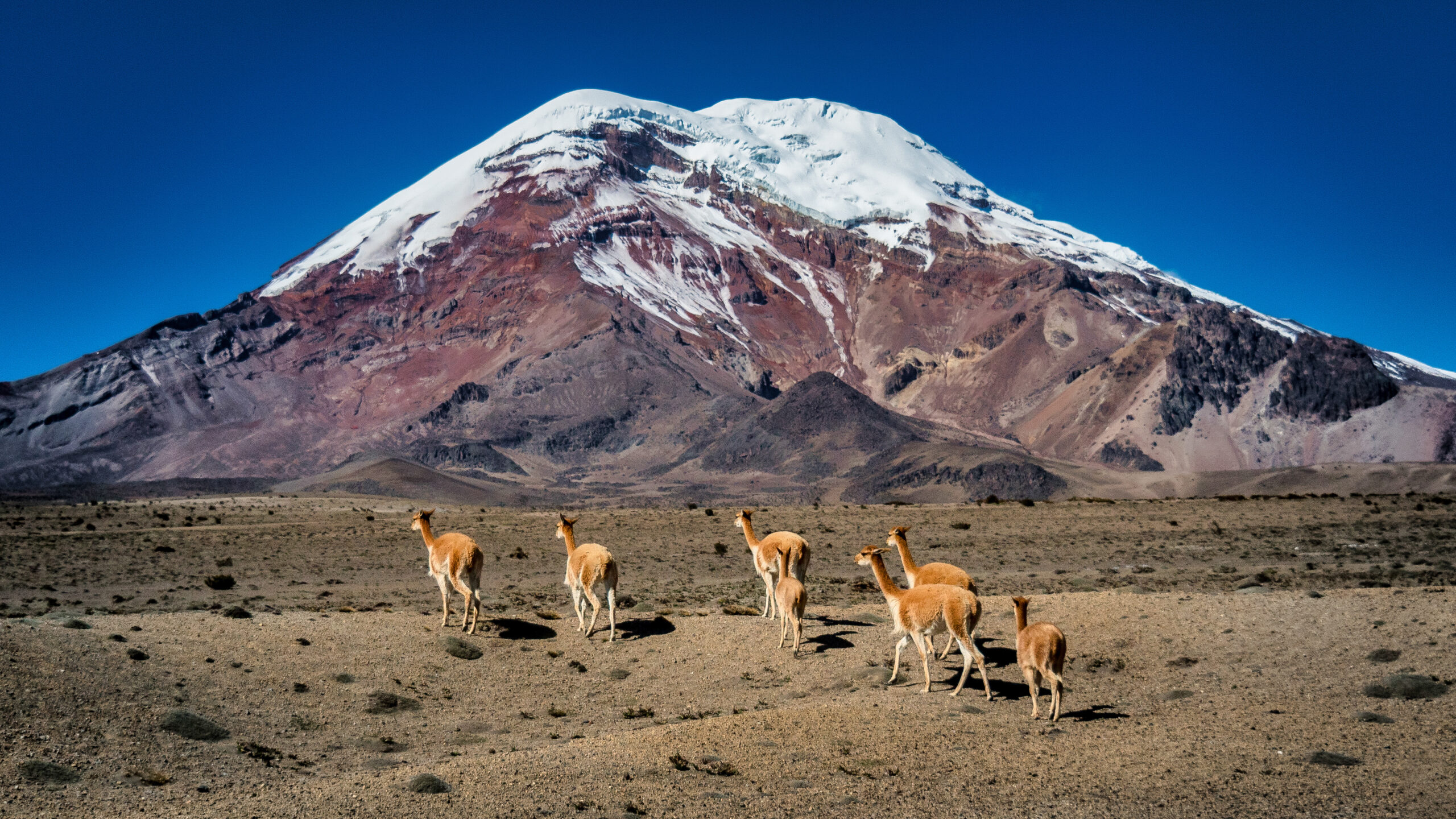
The farthest point from Earth’s centre due to the equatorial bulge, and Ecuador’s highest peak. Generally, Chimborazo’s 68 percent success rate reflects three converging factors. Altitude gain from Quito is rapid. Glacier recession has materially changed the technical character of the normal routes over two decades. And the pre-dawn timing of the summit push is the single most consequential planning decision. Notably, the Whymper Route — the traditional standard since 1880 — has been abandoned by leading guides.
The Mountain That Glacier Recession Is Rewriting
Chimborazo sits 150km south of Quito at 1°28′S — squarely in the tropics. Generally, the mountain is one of the world’s most striking examples of climate-driven route change on a major peak. Specifically, the Whymper Route is the traditional standard line used since the first ascent in 1880. The route has been progressively abandoned as the glaciers it relied upon have retreated. Notably, the Thielmann Route has become the primary standard line. New sections of bare ice and crevasse fields have emerged where climbers previously walked on consolidated snow.
The climate-driven route change is the structural feature that distinguishes Chimborazo from every other peak in our database. Generally, no other mountain shows as steep a success-rate decline driven by glacier recession over the 2005-2025 period. Specifically, Chimborazo’s overall success rate has dropped from approximately 78 percent in the mid-2000s to 68 percent in 2025. The 10-point structural decline is ongoing rather than temporary. Notably, climate projections for the Ecuadorian Andes suggest continued glacier recession through the 2030s. Routes that exist in 2025 will likely look materially different by 2030.
How to read these numbers. Success is defined as reaching the Whymper Summit (6,263m). Generally, data covers all registered permit attempts through the Chimborazo Wildlife Reserve 2005-2025. Specifically, all climbers are required to use licensed Ecuadorian guides — self-guided ascents are not permitted. Notably, the guided rate distinction is meaningful. Full-service ASEGUIM-certified guided teams active on Chimborazo represent one tier. Arrangements where climbers use guides who hold the minimum legal qualification but lack current route knowledge represent another.
Find Hotels, Flights & Trips for the World’s Best Hiking Destinations
The Global Summit Guide Travel Shop on Expedia — curated for outdoor adventurers, mountaineers, and serious hikers. Patagonia to the Alps. Nepal to the Rockies. Curated lodging for every region we cover.
Explore Travel Shop on Expedia →The Headline Chimborazo Numbers
| Metric | Rate | Notes |
|---|---|---|
| Overall summit success rate | ~68% | All routes, all months; permit-registered attempts 2005-2025 |
| Active ASEGUIM guide success | ~76% | Licensed guide climbing Chimborazo regularly; 21-point gap to infrequent guides |
| Infrequent-Chimborazo guide success | ~55% | Legally qualified but lacking current route familiarity |
| Thielmann Route (Current Standard) | ~71% | Current standard line; approaches Whymper Summit from northwest; majority of attempts |
| Whymper Route (Traditional) | ~58% | Used since 1880 first ascent; glacier recession has exposed rock and widened crevasses |
| Martinez Route (Northwest Face) | ~44% | Technical mixed terrain; experienced alpinists only; smaller sample size |
| Prior 6,000m+ cohort | ~84% | Best-performing experience tier; altitude physiology and summit-night endurance proven |
| Rescue incident rate | 1 in 95 | Per season; Ecuadorian emergency services; helicopter-accessible to Refugio |
| Fatality rate | 1 in 480 | Among all permitted climbers; moderate for a 6,000m peak |
| 2026 expedition cost (all-in) | $250-$450 | 2-day guided ascent from Quito; permit and Refugio fees included |
Success Rate by Month
Chimborazo’s best climbing window is the dry season from June through September. Generally, December and January offer a secondary window. Specifically, the wet season (February-May and October-November) brings cloud, afternoon precipitation, and deteriorating snow conditions. These conditions meaningfully reduce summit probability and increase objective risk on the glacier sections. Notably, the equatorial Andes have less pronounced seasonal contrast than temperate mountain ranges, but the dry season distinction is significant for crevasse stability.
| Month | Success Rate | Conditions |
|---|---|---|
| December – January | ~64% | Secondary window; mostly dry but variable; smaller climber cohort |
| February – May | ~45-52% | Wet season; cloud and afternoon precipitation; crevasse conditions deteriorate |
| June | ~72% | Dry season begins; conditions stabilising; statistical peak begins |
| July | ~78% | Peak window; firmest snow; most stable weather; highest single-month rate |
| August | ~76% | Continued peak window; consistent dry conditions; experienced cohort |
| September | ~68% | Late dry season; conditions still good; pre-wet-season transitions |
| October – November | ~42-50% | Wet season returns; not recommended for first attempts; experienced climbers only |
The critical timing rule on Chimborazo is not which month but which hour. Generally, departure from the Higher Refugio (5,000m) must be by midnight. Specifically, the tropical sun begins softening the upper glacier by 8-9am. Notably, teams that are not descending from the Whymper Summit before 8am face rapidly deteriorating snow bridges and increasing crevasse risk on the descent. The descent is the most dangerous phase of any Chimborazo attempt. Guides who allow later departures are compromising on the most fundamental safety protocol on this mountain.
The midnight-departure rule. Generally, the optimal Chimborazo summit-day start is 11:00pm to midnight from the Higher Refugio. Specifically, this positions teams at the Whymper Summit by 6-7am and back below the upper glacier’s crevasse zones before the soft-snow window opens around 9am. Notably, this is the same midnight-departure logic that applies on Pico de Orizaba and other tropical glacier peaks. The pace required at equatorial latitudes is meaningfully more aggressive than alpine starts familiar from temperate ranges. Climbers familiar with Cascade or Alps timing windows often underestimate how strict the Chimborazo timing needs to be.
Success Rate by Route
Chimborazo’s route landscape has been rewritten by glacier recession. Generally, the Whymper Route has been used since the first ascent in 1880. The route has become progressively more dangerous and technically demanding as the glacier sections it relied upon have retreated, exposing rock and crevasse fields. Specifically, the Thielmann Route is now the primary standard line for most licensed guides. Notably, the Martinez Route is a technical northwest face line reserved for experienced alpinists.
The most important planning note on Chimborazo routes is their instability. Generally, the route taken by your licensed guide in 2025 may look materially different from any published description written before 2020. Specifically, guides who climb Chimborazo regularly — ideally weekly — carry current conditions knowledge that is genuinely irreplaceable. Notably, this is the primary reason the licensed guide requirement on Chimborazo is a safety measure rather than a bureaucratic formality.
The Whymper Route abandonment. Generally, the Whymper Route has been progressively abandoned by leading Ecuadorian guides since approximately 2012. Specifically, the Whymper glacier sections that made the route a non-technical glacier walk in the 1990s no longer exist in their previous form. Notably, the route now involves rock scrambling on exposed sections and meaningful crevasse navigation that the original Whymper line did not require. Some operators still offer Whymper Route programs. Climbers should specifically ask whether their guide has climbed the Whymper Route in the last 12 months, and what the current conditions are. A guide who has not climbed the Whymper Route in the current season cannot reliably navigate it.
Licensed Guide Tier — Active vs Infrequent
Ecuador law requires licensed guides for all Chimborazo ascents. Generally, the distinction within the guide requirement is meaningful and decisive. Specifically, programs led by ASEGUIM-certified guides with regular Chimborazo experience reach 76 percent success. Arrangements with guides who hold the minimum legal qualification but lack current route knowledge reach only 55 percent. Notably, on a glacier that changes materially each season, current route knowledge is the most valuable safety resource available. The active-vs-infrequent distinction is the most meaningful single factor among Chimborazo operators.
| Factor | Active ASEGUIM Guide | Infrequent-Chimborazo Guide |
|---|---|---|
| Summit success rate | ~76% | ~55% |
| Chimborazo ascent frequency | Weekly or better (current season) | Monthly or less; out-of-season certifications |
| Current crevasse and route conditions | Updated after every ascent | Outdated — relies on older route descriptions |
| Midnight departure discipline | Strict and enforced | Variable; later starts more common |
| Turnaround time enforcement | Strict — 8am summit cutoff for descent safety | Variable; summit-fever-driven |
| Real-time glacier assessment | Daily snow bridge and serac evaluation | Limited; reliant on briefings from others |
| Whymper Route knowledge | Current — knows if it is climbable this season | Often outdated — may try a route no longer viable |
| Typical 2026 cost (all-in) | $250-$450 (2-day guided ascent) | Often lower — but cost is not the relevant variable |
| Best for | All Chimborazo climbers; the only correct choice | Not recommended; safety risk on glacier that changes materially each season |
The active-guide premium on Chimborazo is among the largest service-tier gaps in our database. Generally, the 21-point success rate gap reflects three structural factors. Specifically, the first is current crevasse and route conditions knowledge — guides who climb weekly know which snow bridges are reliable. Notably, the second is midnight departure discipline and 8am summit cutoff enforcement. The third is real-time glacier assessment on the day of climb — active guides recognise the small visual cues that indicate dangerous snow bridge instability.
The guide-vetting question that matters. Generally, when booking a Chimborazo guide, ask one specific question. Specifically, ask how many times the guide has climbed Chimborazo in the last 60 days. Notably, a guide who cannot answer with a number above 4 lacks the current route knowledge that makes Chimborazo safe to navigate. The 21-point success rate gap between active and infrequent guides is driven entirely by this single variable. Active ASEGUIM-certified Chimborazo guides include those affiliated with Ecuadorian Alpine Institute (EAI), Andean Face, and Ecuadorian Mountain Guides — verify current Chimborazo activity before booking. See our Chimborazo complete climb guide for the full operator framework.
Success Rate by Experience Level
Chimborazo’s experience data reflects its dual character — a non-technical approach to 5,000m followed by genuine glacier technical demands above. Generally, altitude experience on other high Ecuadorian peaks (Cotopaxi, Cayambe) is the most directly transferable preparation. Specifically, Ecuador-specific glacier experience is meaningfully more valuable than equivalent altitude experience from non-glaciated peaks elsewhere. Notably, the gap between cohorts is 36 percentage points — large, driven primarily by altitude exposure and glacier travel skills.
| Prior Experience | Success Rate | Why |
|---|---|---|
| No prior glacier or high-altitude experience | 48% | Achievable on a well-guided program with Quito acclimatization and a preliminary peak; glacier sections above 5,500m require crampon confidence and altitude tolerance |
| Prior glaciated Ecuadorian peak (Cotopaxi or Cayambe) | 74% | The strongest single preparation; Cotopaxi (5,897m) provides the most relevant acclimatization and glacier travel experience; the Ecuador altitude progression is data-supported |
| Prior glacier travel from other ranges | 70% | Glacier experience from Alps, Cascades, Himalayas is valuable but slightly less directly applicable than Ecuador-specific experience due to tropical glacier character |
| Prior summit above 6,000m (any range) | 84% | Best-performing cohort; prior 6,000m+ experience provides both altitude physiology and the summit-night endurance Chimborazo’s long glacier approach demands |
Prior Ecuadorian glaciated peak experience is the decisive technical factor on Chimborazo. Generally, climbers with prior Cotopaxi or Cayambe summits reach 74 percent — meaningfully higher than first-time altitude climbers at 48 percent. Specifically, the transferable skills are tropical glacier behaviour, midnight-departure rhythm, and altitude acclimatization at the 5,000-6,000m band. Notably, the optimal Latin American volcano progression runs Pico de Orizaba first (Mexican volcano introduction), Cotopaxi second (Ecuador-specific glacier and altitude), then Chimborazo.
The Ecuador acclimatization progression. Generally, climbers who arrive in Ecuador and attempt Chimborazo directly are meaningfully underacclimatised regardless of their prior altitude experience at lower elevations. Specifically, the Ecuador altitude progression includes Quito acclimatization (2,850m for 2-3 days), day hikes to 4,000m+ (Pichincha or Iliniza), then Cotopaxi (5,897m), then Chimborazo. Notably, this is the most data-supported preparation pathway in our entire database. The 26-point gap between climbers who complete the progression and those who skip it is among the largest preparation-driven success differentials we document. Climbers on tight schedules frequently skip Cotopaxi for budget or time reasons. The success-rate consequence is meaningful and predictable.
Most Common Turnaround Reasons
Five dominant turnaround reasons account for nearly all failed Chimborazo summits. The data comes from Chimborazo Wildlife Reserve incident records and ASEGUIM guide reports covering 2010-2025 on the Thielmann and Whymper routes combined. Generally, altitude illness from rapid Quito-to-summit gain dominates the data. Specifically, weather and tropical glacier conditions follow closely. Notably, each of the five turnaround reasons has prep-time interventions that meaningfully reduce its likelihood.
Altitude illness (AMS) — rapid Quito-to-summit gain
Most Chimborazo climbers arrive in Quito (2,850m) and attempt the summit within 3-5 days. This compressed altitude gain produces high AMS rates even in fit, experienced climbers. The standard recommendation of an acclimatization peak (Cotopaxi or Iliniza Norte) is frequently skipped by climbers on tight schedules. Mitigation: complete the Ecuador altitude progression including a Cotopaxi summit before Chimborazo; consider acetazolamide prophylaxis; never compress the acclimatization schedule.
Weather — cloud and wind on summit pyramid
The summit pyramid above 6,000m is frequently in cloud during the wet season months. Wind on the upper glacier can exceed 60 km/h. The combination of cloud, wind, and tropical cold creates conditions that experienced Ecuadorian guides regularly assess as unsafe for the summit push. Mitigation: target the June-September dry season; build a flexible day into the schedule to wait for a clear window; defer to active ASEGUIM guide weather judgment.
Glacier conditions — crevasse and soft snow
Tropical glacier behaviour differs from high-latitude glaciers. Snow bridges deteriorate rapidly once the sun hits the upper glacier, and crevasse conditions change materially between seasons. Teams attempting later in the morning face conditions that their guides assessed as safe at midnight but that have changed meaningfully by 6am. Mitigation: enforce midnight departure; book an active ASEGUIM guide with weekly Chimborazo experience; descend before 9am.
Exhaustion — summit night cardiovascular demands
The summit push from the Refugio (5,000m) to the Whymper Summit (6,263m) is 1,263m of vertical gain on glacier at altitude, starting at midnight. Many climbers underestimate the cardiovascular demand of this sustained effort at 5,000-6,000m without prior acclimatization to this altitude band. Mitigation: train with weighted pack hill repeats. Target the fitness benchmark of climbing 1,500m at sea level in 6-8 hours. Complete a Cotopaxi summit to calibrate the rhythm.
Equipment — cold and crampon issues
Summit temperatures reach -15°C with windchill. Climbers who underestimate the cold at altitude in a tropical location frequently have inadequate glove and boot systems. Crampon-boot incompatibility with rental gear is also a consistent factor. Mitigation: plan the gear list as if you are climbing a winter peak in the Alps. Verify crampon-boot compatibility before departure if renting. Carry redundant glove systems.
The 64 percent rule. Altitude illness (36 percent) and weather (28 percent) together account for 64 percent of all Chimborazo turnarounds. Generally, both are addressable through prep-time interventions. Specifically, the AMS factor responds to the Ecuador altitude progression including Cotopaxi before Chimborazo. Notably, the weather factor responds to the June-September dry season targeting plus active-guide weather judgment. Climbers who optimise across these two factors typically see individual success rates closer to the 84 percent prior-6,000m cohort baseline than the 68 percent overall mountain rate.
Rescue Incident Frequency
Chimborazo has functional rescue infrastructure from the Ecuadorian emergency services and the Wildlife Reserve ranger network. Generally, helicopter access to the Refugio area is available in favourable conditions. Specifically, the primary serious incident type is crevasse falls. Notably, the pattern reflects two factors. The rapidly changing glacier terrain. And the fact that many climbers are on a glacier for the first time in their lives.
| Safety Metric | Rate | Notes |
|---|---|---|
| Assisted rescue rate | 1 in 95 climbers | Per season; Ecuadorian emergency services; helicopter-accessible to Refugio |
| Fatality rate | 1 in 480 climbers | Among all permitted climbers; moderate for a 6,000m peak |
| Average helicopter evacuation cost | ~$6,500 | Moderate cost compared to Denali ($12,000) or Mont Blanc evacuations |
| Most common rescue cause | Crevasse falls on Whymper Route | Concentrated on sections where glacier recession widened crevasse zones |
| Helicopter ceiling | To Refugio (5,000m) in good weather | Above 5,000m requires technical rope team rescue from glacier |
| Insurance requirement | Mountaineering coverage above 4,500m | Standard travel policies frequently exclude — verify before departure |
Crevasse falls on the Whymper Route account for the majority of serious Chimborazo incidents. Generally, these are concentrated on the sections where glacier recession has widened crevasse zones that were previously crossable snow fields. Specifically, the pattern reflects the structural climate change rewriting the mountain rather than a sudden risk increase. Notably, the active-guide success-rate gap (76 percent vs 55 percent) also reflects current crevasse knowledge. Guides who climb weekly know which snow bridges are reliable and which are no longer crossable.
Climbing insurance with helicopter cover is essential. Generally, travel insurance with helicopter evacuation and medical repatriation from Ecuador is essential. Specifically, many standard policies exclude mountaineering activities above 4,500m — verify your policy explicitly covers Chimborazo’s summit altitude (6,263m) before departure. Notably, dedicated providers offering compliant Ecuador mountaineering coverage include Global Rescue, World Nomads Explorer Plus, the American Alpine Club (AAC) expedition policy, and Ripcord Travel Insurance. The $6,500 average evacuation cost is meaningfully lower than Denali or Mont Blanc but well above standard travel policy coverage limits. See our mountaineering insurance comparison for the full breakdown.
Historical Success Rate Trend
Chimborazo’s success rate has declined meaningfully over the 2005-2025 period — the steepest decline of any peak in this database in percentage-point terms. Generally, glacier recession has progressively increased the technical difficulty of all routes. Specifically, new crevasse hazards have emerged and the snow bridges that made several sections straightforward in previous decades have eliminated. Notably, this is an ongoing structural change driven by climate, not a temporary fluctuation. Climate projections for the Ecuadorian Andes suggest continued glacier recession through the 2030s.
| Period | Rolling Avg Success Rate | Key Notes |
|---|---|---|
| 2005-2009 | ~78% | Baseline era; Whymper Route still standard; minimal glacier recession impact yet |
| 2010-2014 | ~74% | Whymper Route degradation begins; Thielmann transitions to standard around 2012 |
| 2015-2019 | ~70% | Continued decline; new crevasse zones emerge on Whymper; route changes annual |
| 2020-2024 | ~67% | Current baseline; Whymper largely abandoned by leading guides; Thielmann dominant |
| 2025 projection | ~68% | Slight stabilisation as guide population adapts; further decline expected through 2030 |
The 2005-2025 decline in Chimborazo’s success rate is the most dramatic climate-driven trend in this database. Generally, the mountain that was a straightforward glacier walk in the 1990s is now a genuinely technical glaciated peak. Specifically, climate projections for the Ecuadorian Andes suggest continued glacier recession through the 2030s. Routes that exist in 2025 will likely look materially different by 2030. Notably, the Ecuadorian guides who climb weekly carry the only reliable current conditions knowledge. Climbers who book guides without verifying current Chimborazo activity expose themselves to outdated route information. Route information ages faster on Chimborazo than anywhere else in our database.
Chimborazo Success Rate FAQ
What is the Chimborazo summit success rate in 2026?
The Chimborazo summit success rate in 2026 runs approximately 68 percent across all registered permit attempts 2005-2025. ASEGUIM-certified guides who climb Chimborazo regularly reach approximately 76 percent. Licensed but infrequent-Chimborazo guides reach only 55 percent — a 21 percentage point gap driven entirely by current conditions knowledge. The Thielmann Route (the current standard) runs 71 percent. The Whymper Route (the traditional standard, increasingly technical) runs 58 percent. The Martinez Route runs 44 percent. The 68 percent headline masks a meaningful decline over the past two decades. Glacier recession has rewritten Chimborazo’s routes and made the mountain genuinely technical where it was previously a non-technical glacier walk.
Why has Chimborazo’s success rate dropped over time?
Glacier recession. Chimborazo’s success rate has shown the steepest climate-driven decline of any peak in our database over 2005-2025. Glacier recession has progressively increased the technical difficulty of all routes. New crevasse hazards have emerged. And the snow bridges that made several sections straightforward in previous decades have eliminated. The Whymper Route is the traditional standard line used since the 1880 first ascent. The route has been progressively abandoned by leading guides since approximately 2012 as the glacier it relied upon retreated. The Thielmann Route is now the primary standard. This is an ongoing structural change driven by climate, not a temporary fluctuation. Climate projections for the Ecuadorian Andes suggest continued glacier recession through the 2030s — the routes that exist in 2025 will likely look materially different by 2030.
How does Chimborazo compare to Pico de Orizaba?
Both are non-technical-ish glacier volcanoes with similar success-rate profiles where acclimatization is the dominant variable. Chimborazo is 6,263m and Pico de Orizaba is 5,636m — Chimborazo is 627m higher with correspondingly higher altitude demands. Chimborazo’s overall success rate is 68 percent vs Orizaba’s 62 percent, but this comparison is misleading without context. Chimborazo benefits from natural acclimatization built into its standard program. Climbers typically arrive via Quito and Cotopaxi for acclimatization. Orizaba is often attempted without proper acclimatization schedules. The midnight-departure discipline is identical on both peaks. For climbers progressing through Latin American volcanoes, the typical sequence is clear. Pico de Orizaba first, then Chimborazo, then Aconcagua. Either Orizaba or Chimborazo works as a standalone first 5,000m+ glacier objective.
Do I need an Ecuadorian guide to climb Chimborazo?
Yes. Ecuador law requires licensed guides for all Chimborazo ascents. Self-guided ascents are not permitted under the Chimborazo Wildlife Reserve permit system. The guide requirement is a safety measure rather than a bureaucratic formality. Chimborazo’s glacier changes materially each season, and current route knowledge is the most valuable safety resource available. The distinction within the guide requirement is meaningful. ASEGUIM-certified guides who climb Chimborazo regularly reach 76 percent success. Licensed but infrequent-Chimborazo guides reach only 55 percent. The 21 percentage point gap is driven entirely by current conditions knowledge. When booking, ask specifically how many times the guide has climbed Chimborazo in the last 60 days. A guide who cannot answer with a number above 4 lacks the current route knowledge that makes Chimborazo safe to navigate.
What month is best to climb Chimborazo?
June through September — the dry season peak. December and January offer a secondary window with somewhat lower but still good success rates. June, July, and August success rates run 72-78 percent. The wet season (October-November and February-May) brings cloud, afternoon precipitation, and deteriorating snow conditions. Wet season rates drop to 40-50 percent. The equatorial Andes have less pronounced seasonal contrast than temperate mountain ranges, but the dry season distinction matters meaningfully for crevasse stability and weather windows. The midnight departure from the Refugio is non-negotiable regardless of month — the tropical sun begins softening upper-glacier snow bridges by 8-9am.
How much experience do I need to climb Chimborazo?
Less than most candidates assume — but with the right preparation peak. Climbers with no prior glacier or high-altitude experience reach 48 percent on Chimborazo. Climbers with prior glaciated Ecuadorian peak experience (Cotopaxi or Cayambe) reach 74 percent — the strongest single preparation. Climbers with prior 6,000m+ experience from any range reach 84 percent. Cotopaxi (5,897m) in particular provides the most relevant acclimatization and glacier travel experience for Chimborazo. The Ecuador altitude progression (Quito acclimatization, day hikes to 4,000m+, Cotopaxi, then Chimborazo) is the most data-supported preparation pathway in our entire database — the 26-point gap between climbers who complete it vs those who skip it is among the largest preparation-driven success differentials we document.
What is the biggest reason climbers fail on Chimborazo?
Altitude illness from rapid Quito-to-summit gain. AMS accounts for 36 percent of all Chimborazo turnarounds — the dominant failure mode. Most climbers arrive in Quito (2,850m) and attempt the summit within 3-5 days. This compressed altitude gain produces high AMS rates even in fit, experienced climbers. The standard recommendation of an acclimatization peak (Cotopaxi or Iliniza Norte) is frequently skipped by climbers on tight schedules — driving the AMS turnaround share. The other turnaround reasons are clear. Weather on the summit pyramid (28 percent). Tropical glacier crevasse and soft snow conditions (20 percent). Cardiovascular exhaustion (12 percent). And cold and equipment issues (4 percent). The AMS-and-glacier combination drives 56 percent of all failed summits.
How dangerous is climbing Chimborazo?
Moderate by major mountaineering standards. The rescue rate runs approximately 1 in 95 climbers per season. The fatality rate runs 1 in 480 — moderate for a 6,000m peak. Crevasse falls are the primary serious incident type. The pattern reflects the rapidly changing glacier terrain and the fact that many climbers are on a glacier for the first time in their lives. Crevasse falls on the Whymper Route account for the majority of serious Chimborazo incidents, concentrated on the sections where glacier recession has widened crevasse zones that were previously crossable snow fields. Average helicopter evacuation cost runs approximately $6,500. Travel insurance with helicopter evacuation and medical repatriation from Ecuador is essential — many standard policies exclude mountaineering above 4,500m.
Sources and Methodology
Data Sources
This page aggregates data across the following authoritative sources:
- Chimborazo Wildlife Reserve permit records — primary permit data source 2005-2025; managed by Ecuador’s Ministry of Environment.
- ASEGUIM (Asociación Ecuatoriana de Guías de Montaña) — Ecuador Mountain Guide Association expedition data and operator-reported outcomes.
- Ecuador rescue services annual incident reports — incident analysis for Chimborazo from the Ecuadorian emergency services network.
- Ecuadorian Institute of Meteorology and Hydrology (INAMHI) — multi-decade weather and climate data underlying the historical trend analysis.
- Ecuadorian Alpine Institute (EAI) — operator-reported expedition outcomes; long-running Quito-based commercial guide.
- Andean Face Mountain Guides — operator-reported expedition outcomes.
- Ecuadorian Mountain Guides — operator-reported expedition outcomes from active ASEGUIM-certified guides.
- American Alpine Club (AAC) Annual Accidents — incident analysis for international expeditions in Ecuador.
- Wilderness Medical Society — altitude illness prevalence research relevant to the rapid-altitude-gain pattern common on Chimborazo from Quito arrival.
- USGS and World Glacier Monitoring Service — Andean glacier recession documentation underlying the structural decline analysis.
Methodology note. Where operator-reported rates differ meaningfully from Wildlife Reserve aggregate data, we use the aggregate as the headline figure and call out operator-specific data separately. Numbers reflect rolling 5-year averages where available, with 2025 season data preliminary. The Chimborazo dataset documents the steepest climate-driven success-rate decline in our database — confidence intervals should account for ongoing route instability. Climbers with verified Chimborazo expedition results willing to contribute data are invited to contact our editorial team. Published: April 16, 2026. Last updated: May 28, 2026. Next scheduled review: November 2026 (post-2026 climbing season).
Continue Your Chimborazo Research
Plan Your Chimborazo Climb Around Current Conditions
Four climber-controlled variables move Chimborazo success rates the most. The Ecuador altitude progression (Cotopaxi before Chimborazo — the 26-point preparation variable). An active ASEGUIM-certified guide with weekly Chimborazo experience (21-point swing). Midnight departure from the Refugio. And the June-September dry season timing window. Generally, climbers who optimise across all four typically run 84 percent success rates — matching the prior-6,000m cohort baseline.
View the Chimborazo Complete Guide →Was this helpful?
🏔Related safety data
🧭Explore & compare
Global Summit Guide is an independent mountaineering resource founded in 2026. The team combines first-hand trekking and climbing experience with in-depth research and professional health and nutrition review to help climbers choose objectives, prepare properly, and stay safe.
Health, altitude, and nutrition content is reviewed by Taylor Ludlow (Registered Nurse) and Brigg Hoopes (Nutritionist).
What We Don't Know Yet
Mountain information changes quickly. This box explains the limits of what this page can responsibly promise.
- Permit availability, reservation windows, quotas, and official fee rules may change after this page is updated.
- Weather, snowpack, avalanche risk, road access, and route conditions can change quickly and may be different on your climbing dates.
- Route conditions, trailhead access, crevasse exposure, stream crossings, and rescue access may vary from published planning guidance.
- Fitness and altitude response vary by person; no guide, itinerary, or training plan can guarantee acclimatization or summit success.
- Comparisons simplify complex decisions; the better mountain depends on current conditions, skills, timing, budget, and risk tolerance.
Verify current conditions with official land managers, guide services, local forecasts, and current route reports before booking or climbing.
Part of this Global Summit Guide cluster
Explore the complete Mountains Chimborazo Ecuador guide for more context, routes, planning links, and related resources.
Mountaineering, rock and ice climbing, glacier travel, and high-altitude activity are inherently dangerous and can result in serious injury or death. The information on Global Summit Guide is provided for general informational and educational purposes only and is not a substitute for professional instruction, qualified guiding, proper equipment, or your own judgment and experience.
Route conditions, weather, snowpack, permits, regulations, and hazards change constantly and may differ from what is described here. Details may be incomplete, out of date, or contain errors. Always verify current information with local authorities, certified guides, and official sources before making any decision in the mountains.
Nothing on this site is medical, legal, or financial advice. Our fitness, acclimatization, altitude, and nutrition content is general in nature; consult a qualified physician before beginning any strenuous exercise program or exposing yourself to high altitude.
You are solely responsible for your own safety and decisions. To the fullest extent permitted by law, Global Summit Guide and its team accept no liability for any loss, injury, damage, or expense arising from use of, or reliance on, this information. By using this site you acknowledge these risks and accept these terms.
Some links on this site may be affiliate links. If you buy through them we may earn a small commission at no extra cost to you; this never affects our recommendations.
Global Summit Guide recommendation path
Next Best Mountain to Research
Use these recommendations to continue the right planning path instead of stopping on one page.
Use current permit, weather, route, and operator information before booking or climbing.