
Mount Blackburn routes guide: the northwest ridge, southeast ridge, and the historic 1912 keen line
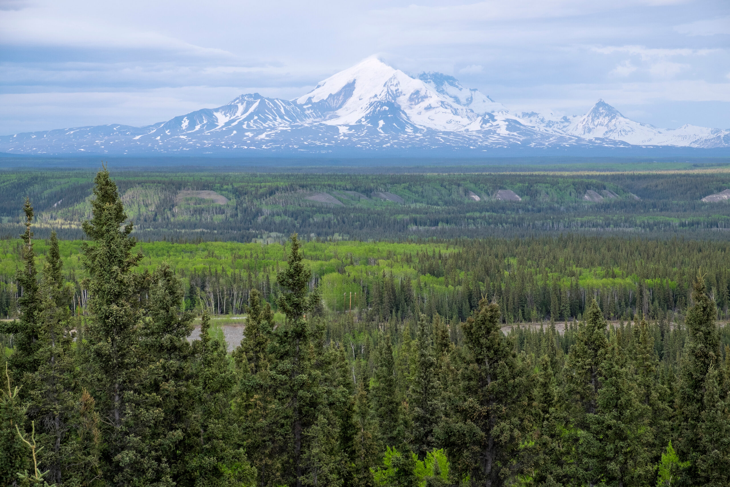
Mount Blackburn rises to 4,996 m (16,390 ft) in the heart of Alaska’s Wrangell Mountains, the crown jewel of the range and the fifth-highest peak in the United States. It is also one of the least-climbed major American mountains — less than 50 successful parties have summited via any route since the true summit was first reached in 1958, and fewer than 50 summit attempts have been recorded in the last 30 years. The mountain is an ancient shield volcano permanently covered in ice, with a west face that drops over 3,350 m in less than 6.4 km, and its proximity to the turbulent Gulf of Alaska produces some of the most severe weather of any major North American peak.
This guide covers all three documented routes on Mount Blackburn with verified grades, first-ascent history, ski-plane logistics, and what to expect on each line. We open with the modern standard Northwest Ridge from the Nabesna Icefield — the 1958 true-summit first-ascent route by Gilbert, Wahlstrom, Gmoser, Bitterlich, and Blumer — followed by Gerry Roach’s 1977 Southeast Ridge from the Kennicott Glacier side, and finally the historic 1912 Dora Keen East Face line, no longer practical due to climate change but central to understanding the mountain’s place in Alaskan climbing history. Each route demands a multi-week expedition commitment and the kind of weather tolerance that defines Wrangell Mountain climbing.
Route comparison at a glance
Mount Blackburn has three documented routes, each accessed from a different side of the massif. The Northwest Ridge is the modern standard and the route virtually all guided expeditions use. The Southeast Ridge is a less-traveled alternative with strong historical significance. The Keen East Face route is included for historical completeness — it is the line of the famous 1912 first East Peak ascent, but climate change has made it impractical.
| Route | Grade | Access | Historical significance | Status |
|---|---|---|---|---|
| Northwest Ridge (“Japanese Ridge”) | AK 3 · Steep snow/ice | Ski-plane to Nabesna Icefield (7,000 ft) | 1958 West Peak first ascent | Modern standard |
| Southeast Ridge | AK 3-4 · Complex | Kennicott Glacier from McCarthy | 1977 Roach 2nd East Peak ascent; 1st winter ascent route | Rarely climbed |
| East Face / Kennicott Glacier (Keen Route) | Historic only | Kennicott Glacier (long approach) | 1912 Dora Keen East Peak first ascent | Impractical due to climate change |
The “two summits” issue
Mount Blackburn has two summits: the West Peak at 4,996 m (16,390 ft) — the true summit — and the East Peak (Kennedy Peak), about 60 m lower at approximately 4,936 m. The crucial historical fact is that authorities only discovered in the 1960s that the West Peak was higher. Until then, the East Peak was thought to be the highest point, which is why Dora Keen’s 1912 East Peak ascent was celebrated for half a century as the “first ascent of Mount Blackburn” — and why Leon Blumer’s submission to the 1959 American Alpine Journal about the 1958 West Peak climb was titled “Mount Blackburn – Second Ascent”. The 1958 Gilbert-Wahlstrom-Gmoser-Bitterlich-Blumer climb is now recognized as the first true-summit ascent.
1. Northwest Ridge — the modern standard and 1958 first-ascent route
The Northwest Ridge — sometimes called the “Japanese Ridge” after its frequent use by Japanese expeditions in the decades following the first ascent — is the modern standard route on Mount Blackburn. The line was opened by the 1958 first-ascent party of the West Peak: Bruce Gilbert, Dick Wahlstrom, Hans Gmoser, Adolf Bitterlich, and Leon Blumer, who reached the true summit on 30 May 1958 not knowing they had made the first ascent. The route is accessed by ski-plane from McCarthy or Chitina to a basecamp at approximately 7,000 ft on the Nabesna Icefield, and is the route used by virtually all commercial guided expeditions today.
Northwest Ridge (1958 First-Ascent Route)
AK 3 · Steep snow + iceAccess — ski-plane from McCarthy or Chitina
The route begins with a ski-plane flight from McCarthy (the historic mining town in Wrangell-St. Elias National Park) or Chitina, operated by Wrangell Mountain Air or another small commercial operator. Climbers fly directly north over the striated Kennicott Glacier and the endless icefalls of the Wrangell Mountain interior, landing at approximately 7,000 ft on the Nabesna Icefield. There is no road access, no trail approach, and no walk-in option — the ski-plane is the only practical way to reach this side of the mountain in summer climbing conditions.
The basecamp is established on the icefield with full expedition equipment: tents, fuel, stoves, sleds for hauling, glacier-rescue gear, and 14-21 days of food. Communication is by satellite phone or InReach — there is no mobile signal in the Wrangell Mountains, and the nearest road is over 30 miles away. The basecamp is exposed to the full force of Gulf of Alaska weather systems and is regularly storm-bound for 3-5 day stretches.
Lower route — basecamp to Camp 1
From the Nabesna basecamp at 7,000 ft, the route ascends the broken upper Nabesna Glacier through extensively crevassed terrain to Camp 1 at approximately 10,000 ft. The lower section involves significant route-finding through icefall and serac terrain — climate change has progressively opened up the lower glacier and the crevasse hazard has increased over recent decades. Standard practice is full glacier travel with rope team spacing of 15-20 m, with deadmen, pickets, and ice screws ready for crevasse rescue.
Middle route — Camp 1 to Camp 2 (the ridge proper)
Above Camp 1, the route gains the lower Northwest Ridge through steep snow and mixed snow-and-ice slopes up to 45-50 degrees. The ridge crest is reached at approximately 12,000 ft, and the climbing transitions to predominantly ridge-line work with extensive exposed sections. Camp 2 is established at approximately 13,000-14,000 ft on a relatively flat section of the upper Nabesna Icefield or on a snow shoulder of the ridge proper.
Upper route — Camp 2 to summit
The upper ridge is the defining feature of the climb: an exposed, knife-edged corniced ridge with limited space for camping, requiring extended pushes from the highest established camp. The 16-day expedition outline from St. Elias Alpine Guides describes the upper section character bluntly: “the wild nature of the route challenges climbers with exposure, steep snow and ice, wicked storms, over 8,000 vertical feet of climbing, and extended pushes with limited space for camping on the high, thin, and exposed ridge.”
The final summit push climbs from the highest camp (typically Camp 3 at approximately 15,000 ft on the ridge crest) up the final snow ridge to the West Peak summit at 16,390 ft. The summit ridge is generally narrow with significant exposure on both sides. Total time from basecamp to summit and return is rarely accomplished in under 14 days due to weather, and 18-21 days is more typical.
Descent
Descent retraces the ascent line, with all camps and fixed protection retrieved on the way down. The descent typically takes 3-5 days depending on weather and the state of the lower glacier. The ski-plane pickup at the Nabesna basecamp completes the trip — but as with many Alaskan expeditions, the pickup is weather-dependent and parties should budget for 1-3 additional days of waiting at basecamp before the plane can fly.
Why this route
- Historic line — the 1958 true-summit first-ascent route
- Most-documented approach with established commercial guide service
- Ski-plane access from McCarthy is the most reliable Wrangell logistics
- Roughly 39 documented ascents per SummitPost — the most-traveled line on the mountain
Why not
- Brutal weather — 14-21 day expeditions regularly fail due to storms
- Exposed upper ridge with limited camping options creates significant decision-making pressure
- Ski-plane costs are substantial — $1,500-3,000 per person for round-trip air access
- Cost and remote logistics — total expedition cost from outside Alaska runs $8,000-15,000+ per climber
Editor’s note: the “second ascent” that was actually the first
The 1958 NW Ridge climb is one of the great accidental first ascents in American climbing history. Bruce Gilbert, Dick Wahlstrom, Hans Gmoser, Adolf Bitterlich, and Leon Blumer reached the West Peak on 30 May 1958 believing Dora Keen had already done the same in 1912. The 1959 American Alpine Journal printed Blumer’s report under the title “Mount Blackburn – Second Ascent.” It would take until the 1960s, when new USGS survey work and more accurate USGS maps were released, before the team learned the West Peak was higher than Keen’s 1912 East Peak — and that they had made the true first ascent. The 1958 team is now properly credited with the first ascent of the true summit.
2. Southeast Ridge — the 1977 traverse line and 1st winter ascent route
The Southeast Ridge is the second documented route to the summit, opened by Gerry Roach in 1977 as part of a remarkable double achievement: the second ascent of the East Peak (the first ascent since Dora Keen’s 1912 climb), followed by a traverse to the West Peak and descent via the Northwest Ridge — the first traverse of the Mount Blackburn massif. The Southeast Ridge route is significantly less-traveled than the NW Ridge but offers a different character of climbing and approaches the mountain from the Kennicott Glacier side via McCarthy.
Southeast Ridge (Roach 1977 / First Winter Ascent Route)
AK 3-4 · ComplexThe 1977 Roach traverse
Gerry Roach’s 1977 expedition is one of the great Mount Blackburn achievements. The East Peak (Kennedy Peak) had gone “nearly 70 years without a human footprint” since Dora Keen’s 1912 ascent. Roach’s party made the second ascent of the East Peak via the Southeast Ridge from the Kennicott Glacier side, then crossed the connecting ridge to the West Peak (still believed by some at the time to be technically a separate ascent), and descended via the Northwest Ridge — completing the first traverse of the Mount Blackburn massif. The Roach route opened up the Southeast Ridge as a viable line.
The first winter ascent
The Southeast Ridge was also the route of the first winter ascent of Mount Blackburn — and the first winter ascent of any peak in the Wrangell Mountains — by Alaskan climbers Art Ward, Gary Tandy, Steve Tandy, John Pinamont, and Don Pahlke on 15 March. The expedition used no air support except a single supply drop, traveling instead by snow-machine-towed sleds 35 miles from Chitina up the Kuskulana Glacier, then crossing the 8,900 ft pass between the Kuskulana and Kennecott Glaciers in temperatures consistently between -22 °F at Chitina and -30 °F at the upper pass. The party constructed an igloo and snow cave on the pass, received their single airdrop, then relayed to Camp 1 at 11,000 ft, placed 1,900 feet of fixed line between the pass and Camp 2 at 13,800 ft, and made the summit push as a 20-mile round trip with 10 miles at altitudes exceeding 16,000 ft. The ascent remains the second-highest winter summit yet attained in Alaska.
Route character
The Southeast Ridge involves: a long Kennicott Glacier approach (the same glacier system Dora Keen used in 1912, now substantially retreated), a complex pass-crossing between the Kuskulana and Kennecott Glaciers at approximately 8,900 ft, a steep snow-and-ice ridge with corniced sections, knife-edged cornice traverses above the Kennecott icefall, and a final ridge approach to the East Peak before any traverse to the West Peak. The grade is AK 3-4 — technically more demanding than the NW Ridge, with more cornice work and more complex route-finding.
Who this route is for
- Self-supported parties seeking a quieter line on the mountain
- Strong alpinists looking for the full Roach traverse (SE Ridge up, NW Ridge down)
- Winter ascent parties — the route’s first winter ascent established its viability for the cold season
- NOT first-time Mount Blackburn climbers or typical guided ascents — the NW Ridge is the practical standard
3. East Face / Kennicott Glacier — the historic 1912 Keen line
The East Face route via the Kennicott Glacier is the historic line of Dora Keen and George Handy’s 1912 first ascent of the East Peak (Kennedy Peak) — the climb that was celebrated for fifty years as the first ascent of Mount Blackburn before the 1960s USGS resurvey revealed that the West Peak was actually higher. The Keen route is included here for historical completeness but is no longer a practical climbing objective: glacial recession and climate change have made the East Face route impassable in modern conditions.
East Face / Kennicott Glacier (Keen 1912)
Historic onlyThe 1912 Keen expedition
Dora Keen led one of the most remarkable American mountaineering expeditions of the pre-WWI era. In 1911, inspired by a U.S. Geological Survey report, Keen decided to attempt Mount Blackburn. She organized her expedition from the nearby Kennicott Copper Mine, recruiting four local gold miners — Charlie McGonagall, Pete Anderson, Billy Taylor, and Tom Lloyd — along with George Handy and a German adventurer.
The party approached the mountain from the southwest, following the Kennicott Glacier toward the base of Blackburn. Dog sleds were used to travel 30 miles up the Kennicott Glacier from the copper mine. The team then forged a route up the broken East Face, crossing deep crevasses and rifts in the ice over 30 days of climbing. Summiting the East Peak with few supplies, the team did not traverse over to the West Peak — and indeed, in 1912 there was no reason to believe the West Peak might be higher.
Keen later wrote a famous article for the Saturday Evening Post titled “First up Mount Blackburn”. The Keen ascent is now recognized as the first ascent of an Alaskan peak by a woman — a watershed moment in American women’s mountaineering history. Of course, as SummitPost notes, “she was only the first to ascend the East Peak.”
Why the route is no longer practical
SummitPost states the modern reality directly: “With increasing global temperatures, the Kennicott Glacier/East Face route is no longer practical.” The glacier has retreated substantially, the East Face has become more broken and rockfall-prone, and the long Kennicott Glacier approach now involves significantly more hazardous icefall navigation than the 1912 party encountered. Modern attempts on the East Face would be substantially more dangerous than the original ascent.
The Keen route’s historical significance remains enormous — Dora Keen’s 1912 climb is a landmark in American women’s climbing history, and the Saturday Evening Post article inspired a generation of women alpinists. But the route itself is now a piece of climbing history rather than a practical objective.
The Wrangell Mountains context — why so few climbers
SummitPost summarizes the access problem directly: “Due to frequent storms, seasonal inaccessibility and the general remoteness of this peak, less than 50 summit attempts have been made in the last 30 years.” Several factors combine to make Mount Blackburn one of the least-climbed major American mountains:
Severe weather from the Gulf of Alaska
Mount Blackburn experiences 2,310 mm of annual rainfall and 1,930 mm of snow — far higher than the Alaska Range or the Brooks Range. The Wrangells lie close to the Gulf of Alaska and intercept moisture-laden Pacific systems before the storms reach the interior. Storms, avalanches, dangerous crevasses, and serac falls are common. Multi-week storm cycles are normal during the standard climbing season (May-June), and parties regularly use 50% or more of their expedition time waiting out weather.
Remote access — no road, no trail, no infrastructure
Unlike Denali (which has the famous Kahiltna basecamp with multiple commercial operators and air taxi service running daily during the season), Mount Blackburn has no equivalent infrastructure. The Nabesna Icefield basecamp must be established fresh by each expedition. The nearest road is over 30 miles away. Air taxi service from McCarthy or Chitina is limited, weather-dependent, and substantially less reliable than the Talkeetna-Denali air service.
No permit system but check-in recommended
SummitPost confirms: “No permits required. Climbers are advised to check-in at the park ranger station in case of an emergency. Firearms are allowed for defense as grizzlies are common within the park.” The lack of a permit system reflects the lack of climber traffic — there is no need for the permit infrastructure that Denali requires for its 1,000+ annual climbers.
The economic and logistical barrier
A typical Mount Blackburn expedition costs $8,000-15,000+ per climber when air access, food, fuel, equipment, and guide services are included. The 14-21 day commitment is longer than most working professionals can take, and the success rate is significantly lower than for Denali. Together, these factors limit the climbing population to a small group of dedicated Alaskan expedition climbers and a few guided commercial trips per year.
The expedition reality
Mount Blackburn is not a peak for first-time expedition climbers. The combination of brutal Gulf of Alaska weather, remote ski-plane access, 8,000+ vertical feet of climbing on exposed terrain, and 14-21 day commitment makes the mountain one of the more serious objectives in American mountaineering. Climbers planning an attempt should have prior Alaskan expedition experience (Denali, the St. Elias Range, the Alaska Range), comfort with multi-week storm cycles in tents, glacier and crevasse rescue competence, and the financial commitment for a major expedition. Guided ascents through commercial operators like St. Elias Alpine Guides provide the most reliable framework for first-time climbers on the mountain.
Choosing your route
The route selection framework for Mount Blackburn is genuinely simple:
- First Mount Blackburn ascent, standard objective: Northwest Ridge from the Nabesna Icefield. The 1958 first-ascent route, the most-documented line, the route used by commercial operators like St. Elias Alpine Guides, and the only option for typical guided expeditions.
- Experienced Alaska alpinist seeking a quieter line: Southeast Ridge from the Kennicott Glacier. The 1977 Roach line, the route of the first winter ascent, and a more committing technical proposition.
- Climber attempting a full traverse: The Roach 1977 traverse — Southeast Ridge up to East Peak, traverse to West Peak, descend Northwest Ridge. A serious commitment, with major logistics on both sides of the mountain.
- Winter ascent aspirant: Southeast Ridge — the route of the first winter ascent and the proven line for cold-season attempts.
- Historical-line seeker (East Face Keen route): Not recommended. The route is impractical due to climate change, and modern attempts would be substantially more dangerous than the original 1912 climb.
For all routes, the Wrangell Mountain Park ranger station check-in is strongly recommended, firearm carry is permitted for grizzly defense, and full expedition self-sufficiency is essential. Mount Blackburn is one of the great quiet objectives in American mountaineering — a peak with the height of a major Alaska Range summit, the historical depth of pre-WWI expedition climbing, and a current ascent count that has stayed below 50 for three decades. Climbers who summit join a very small club.
Other parts of the Mount Blackburn guide
Routes is one of six topics covered in the full Mount Blackburn climbing guide. Each sub-guide goes deep on one aspect of the climb.
Routes Guide
The NW Ridge from Nabesna Icefield, the SE Ridge from Kennicott Glacier, and the historic 1912 Keen East Face line — the three documented routes on PNG’s fifth-highest peak.
Gear List
The complete equipment list for the 14-21 day NW Ridge expedition — double boots, full glacier kit, ski-plane logistics, and the gear for Gulf of Alaska weather.
Permits & Logistics
Coming soon — Wrangell Mountain Air booking, McCarthy/Chitina access, ranger check-in, and the expedition cost breakdown.
Training Plan
Coming soon — fitness and skills preparation for a 14-21 day Alaskan expedition with 8,000+ vertical feet of climbing.
Weather & Best Season
Coming soon — Gulf of Alaska weather patterns, the May-June window, and managing multi-week storm cycles.
Difficulty & Safety
Coming soon — the AK Grade 3 reality, crevasse hazard management, grizzly defense at basecamp, and helicopter rescue limitations.
Mount Blackburn routes — frequently asked questions
What is the standard route on Mount Blackburn?
The modern standard route on Mount Blackburn is the Northwest Ridge, sometimes called the “Japanese Ridge”, accessed by ski-plane to a basecamp at approximately 7,000 ft on the Nabesna Icefield. The route was the line of the first ascent of the true West Peak summit on 30 May 1958 by Bruce Gilbert, Dick Wahlstrom, Hans Gmoser, Adolf Bitterlich, and Leon Blumer. From the Nabesna basecamp at 7,000 ft the route climbs roughly 9,400 vertical feet to the 16,390 ft summit through extensive crevassed terrain, steep snow and ice up to 50 degrees, exposed corniced ridges, and a final knife-edge summit ridge. The standard expedition takes 14-21 days including weather delays. Less than 50 successful parties have summited via this route since 1958, making Mount Blackburn one of the least-climbed major Alaskan peaks.
Who made the first ascent of Mount Blackburn?
The first ascent of Mount Blackburn’s true summit, the West Peak at 4,996 m (16,390 ft), was made on 30 May 1958 by Bruce Gilbert, Dick Wahlstrom, Hans Gmoser, Adolf Bitterlich, and Leon Blumer via the Northwest Ridge from the Nabesna Icefield. The team famously did not know they had made the first ascent at the time — Blumer’s submission to the 1959 American Alpine Journal was titled “Mount Blackburn – Second Ascent”, because the team believed Dora Keen and George Handy had reached the true summit in 1912. The 1960s USGS resurvey revealed that the East Peak (Kennedy Peak) climbed by Keen was actually about 60 meters lower than the West Peak, and the 1958 NW Ridge climb retroactively became the first ascent.
Who was Dora Keen and what did she climb on Mount Blackburn?
Dora Keen was an American mountaineer who made the first ascent of Mount Blackburn’s East Peak (also called Kennedy Peak) in 1912 with George Handy, a climb that was later recognized as the first ascent of an Alaskan peak by a woman. Keen organized her expedition from the nearby Kennicott Copper Mine, recruiting four local gold miners (Charlie McGonagall, Pete Anderson, Billy Taylor, Tom Lloyd) and a German adventurer. The party used dog sleds to travel 30 miles up the Kennicott Glacier and then forged a route up the broken East Face, crossing deep crevasses and rifts in the ice over 30 days. Keen wrote a famous article for the Saturday Evening Post titled “First up Mount Blackburn” — though it was later established that she had reached only the East Peak, about 60 m lower than the true West Peak summit. The Keen East Face route is no longer practical due to glacial recession and climate change.
How difficult is Mount Blackburn?
Mount Blackburn is graded Alaska Grade 3 with the Northwest Ridge standard route involving extensive crevassed glacier travel, steep snow and ice slopes up to 50 degrees, exposed corniced ridges with knife-edge terrain, and approximately 8,000 vertical feet of climbing from the 7,000 ft Nabesna Icefield basecamp to the 16,390 ft summit. The mountain has severe weather because of its proximity to the turbulent Gulf of Alaska — storms, avalanches, dangerous crevasses, and serac falls are common. With 2,310 mm of annual rainfall and 1,930 mm of snow, Mount Blackburn experiences some of the most adverse weather of any major Alaskan peak. Less than 50 summit attempts have been made in the last 30 years, and the success rate is significantly lower than for Denali due to the weather and the lack of established infrastructure.
What was the first winter ascent of Mount Blackburn?
The first winter ascent of Mount Blackburn — and the first winter ascent of any peak in the Wrangell Mountains — was made on 15 March by Alaskan climbers Art Ward, Gary Tandy, Steve Tandy, John Pinamont, and Don Pahlke via the Southeast Ridge from the Kennicott Glacier side. The expedition used no air support except a single supply drop, traveling instead by snow-machine-towed sleds 35 miles from Chitina up the Kuskulana Glacier, then crossing the 8,900 ft pass between the Kuskulana and Kennecott Glaciers. Temperatures ran from -22 °F at Chitina to -30 °F at the upper pass. The party placed 1,900 feet of fixed line between the pass and Camp II at 13,800 ft, and made the summit push as a 20-mile round trip with 10 miles at altitudes exceeding 16,000 ft. The ascent remains the second-highest winter summit yet attained in Alaska.
Who was Mount Blackburn named after?
Mount Blackburn was named in 1885 after Senator Joseph Clay Stiles Blackburn, a U.S. Senator from Kentucky who was a supporter of the Alaska purchase. The local Athabascan people called the mountain K’ats’i Tl’aadi in the Ahtna language. Mount Blackburn is the highest peak in the Wrangell Mountains within Wrangell-St. Elias National Park, at 4,996 m (16,390 ft) making it the fifth-highest peak in the United States and the 12th-highest in North America. The mountain has two summits: the West Peak at 4,996 m is the true summit, and the East Peak (also called Kennedy Peak) is about 60 m lower. Authorities only discovered in the 1960s that the West Peak was higher than the East Peak.