
Last updated May 21, 2026
Mauna Kea Climb Guide: Mauna a Wākea, the Sacred Summit of Hawaiʻi & the World’s Tallest Mountain from Base to Peak (2026)
Mauna Kea is the highest mountain in Hawaii at 4,207m / 13,803 ft above sea level — but measured from its base on the Pacific seafloor, it rises 10,210m (33,500 ft), making it the world’s tallest mountain, exceeding Everest by 4,000 feet. To Native Hawaiians, the mountain is Mauna a Wākea — the firstborn child of the sky father Wākea and the earth mother Papahānaumoku, the piko (umbilical cord) of the Hawaiian people, and the most sacred site in the Hawaiian Islands. Visiting climbers should understand they are approaching land that remains actively sacred today, subject to ongoing 2014-2026 Native Hawaiian protector movements, the 2022 Mauna Kea Stewardship Authority transition, and continuing cultural negotiations over the mountain’s future. Here’s the verified 2026 planning data with appropriate cultural context.
Mauna Kea Guides — All Sub-Topics
Mauna Kea Science Reserve and Ice Age Natural Area Reserve. Mauna Kea’s summit region encompasses two principal protected designations: the Mauna Kea Science Reserve (approximately 13,300 acres above 11,500 ft, currently under University of Hawaiʻi master lease through 2033) and the Mauna Kea Ice Age Natural Area Reserve (3,894 acres protecting unique Pleistocene-era geological features and the alpine stone desert ecosystem). The mountain was designated a US National Natural Landmark in November 1972. As of 2022, Act 255 established the Mauna Kea Stewardship and Oversight Authority (MKSOA) — a new state agency that assumed governance authority on 1 July 2023 and will fully replace University of Hawaiʻi management of the science reserve lands by 1 July 2028. The 2022-2028 transition represents one of the most significant changes in any major US peak’s management framework in recent history — directly resulting from the 2014-2019 Thirty Meter Telescope (TMT) controversy and the broader Native Hawaiian protector movement.
The History of Mauna a Wākea
Mauna Kea — properly Mauna a Wākea, “the Mountain of Wākea” (also translated as “White Mountain” referring to its seasonal snow cap) — rises 4,207 meters (13,803 feet) on the Big Island of Hawaiʻi. The mountain is the highest point in the Hawaiian Islands, the highest point in the State of Hawaii, and the 6th-highest US state high point after Denali, Mount Whitney, Mount Elbert, Mount Rainier, and Mount Massive’s neighbor Mount Elbert. The summit is approximately 125 feet (38 m) higher than neighboring Mauna Loa — Hawaii’s second-highest peak (and the largest active volcano in the world by volume).
Mauna Kea is a dormant shield volcano in the post-shield phase of Hawaiian volcanic evolution. The mountain’s last confirmed eruption was approximately 4,500 years ago (radiocarbon-dated to roughly 2460 BCE ± 100 years). The oldest dated rocks at the summit are approximately 237,000 ± 31,000 years old, with the mountain estimated at approximately 1 million years total geological age. The Hawaiʻi Volcano Observatory classifies Mauna Kea as dormant — capable of future eruption but without measurable current activity, in contrast to actively erupting Kīlauea and the more recently-active Mauna Loa.
Find Hotels, Flights & Trips for the World’s Best Hiking Destinations
The Global Summit Guide Travel Shop on Expedia — curated for outdoor adventurers, mountaineers, and serious hikers. Patagonia to the Alps. Nepal to the Rockies. Curated lodging for every region we cover.
Explore Travel Shop on Expedia →The Sacred Mountain — Mauna a Wākea and Hawaiian Cosmology. In Hawaiian religion and Native Hawaiian (Kānaka Maoli) tradition, Mauna Kea is Mauna a Wākea — the firstborn child of the sky father Wākea and the earth mother Papahānaumoku (often shortened to Papa). The mountain is the piko (umbilical cord, navel) of the Hawaiian people — the place where land, sea, and sky are eternally connected, where the spirit realm meets the physical world. In ancient Hawaiian tradition, the summit was wao akua — the “realm of the gods” or “the place where benevolent spirits reside” — restricted by kapu (ancient sacred law) to high-ranking aliʻi (chiefs) and kahuna (priests). The snow goddess Poliʻahu was said to dwell on the upper slopes, sometimes in rivalry with the fire goddess Pele, who lives at Kīlauea. Lake Waiau, a small alpine lake at 13,020 ft within the Puʻu Waiau cinder cone, holds particular significance — Hawaiian families historically (and still today) bring the piko of newborn children to the lake, symbolizing the child’s eternal connection to the land. The Hawaiian creation chant Kumulipo describes the cosmic origins of the islands beginning with Mauna a Wākea. Climbers should understand that this mountain is not “former sacred site” history — it is actively sacred today. Ceremonies still occur regularly at the summit and at Lake Waiau. The appropriate posture for visitors is reverence and respect, not “conquering.”
~1100 CE – 1778: The Adze Quarry and Pre-Contact Hawaiian Era
Polynesian voyagers — the ancestors of modern Native Hawaiians — reached the Hawaiian Islands as part of the broader Polynesian migration across the Pacific. The most widely accepted dating places Polynesian settlement of Hawaiʻi between approximately 400 CE and 1000 CE, with continuous occupation from at least 1100 CE forward. By 1100 CE, Native Hawaiians had established the Mauna Kea Adze Quarry (Keanakākoʻi) — the largest pre-contact stone tool quarry in the Pacific Ocean basin. The quarry sits at approximately 12,000-12,400 ft elevation on the southern slopes of the summit, where toolmakers extracted dense, fine-grained basalt (a hard, durable volcanic rock) for the manufacture of koʻi (adzes) — the principal woodworking tools of Hawaiian society, used for everything from canoe construction to house-building. The Adze Quarry shows continuous use from ~1100 CE through European contact, with thousands of stone fragments, partially completed adzes, and shrine structures preserved across the site. Modern archaeological work has documented over 100 ceremonial structures (ahu, shrines, burial sites) on the upper mountain — confirming that Mauna Kea was a continuously visited and ceremonially significant location for at least 700-900 years before any written European record began.
King Kalākaua — the last reigning King of Hawaiʻi (1874-1891) — famously visited the summit of Mauna Kea in 1881 during a royal tour of the mountain. Kalākaua’s visit reaffirmed the mountain’s sacred status in late-monarchy Hawaiian society and is preserved in oral histories and royal records.
14 August 1823: Joseph Goodrich’s First Recorded Ascent
The first recorded ascent of Mauna Kea by a non-Hawaiian was made on 14 August 1823 by Joseph F. Goodrich (1794-1852), an American Congregationalist missionary who had arrived in Hawaiʻi in 1823 with the second company of American Board missionaries. Goodrich was based at Hilo and made his ascent accompanied by Hawaiian guides whose names were unfortunately not preserved in the written record. He reached the summit area and conducted basic measurements; his account was published in missionary correspondence and later in Hiram Bingham’s A Residence of Twenty-One Years in the Sandwich Islands (1847).
The Goodrich ascent is the first verified historical record rather than the literal first ascent. Native Hawaiian Kānaka Maoli had been visiting and climbing the summit for at least 700-900 years before Goodrich, with archaeological evidence at the Adze Quarry, multiple summit shrines, burial sites, and ceremonial structures all documenting continuous Indigenous presence. The “first ascent” framing — like at most other Indigenous-inhabited peaks — is an artifact of the European exploration tradition and does not reflect the actual human history of the mountain. Hawaiian guides accompanied virtually all early European-American ascents and knew the mountain intimately from generations of cultural use.
1841: The US Exploring Expedition
The US Exploring Expedition (1838-1842) — the major American naval expedition led by Lieutenant Charles Wilkes — visited Hawaii in 1841 and conducted the first formal scientific survey of Mauna Kea. James Dwight Dana, the expedition’s geologist (and later the founder of modern American geology), made detailed observations of the volcano and the surrounding terrain. The Wilkes survey produced the first reasonably accurate altitude measurements of Mauna Kea (initially estimated at approximately 13,700 ft, close to the modern accepted 13,803 ft) and established the mountain in the international scientific record.
November 1972: National Natural Landmark Designation
Mauna Kea was designated a US National Natural Landmark in November 1972 — a federal designation recognizing the mountain’s exceptional geological and ecological significance. The designation does not provide regulatory protection (unlike a National Park or National Monument) but formally acknowledges the mountain’s natural importance. The Ice Age Natural Area Reserve was established the same period, protecting the unique alpine stone desert ecosystem and the Pleistocene-era glacial features (Mauna Kea was glaciated approximately 14,000 years ago during the last ice age — the only Hawaiian peak with confirmed glaciation evidence).
1968: The First Astronomical Observatory
The astronomical development of Mauna Kea began in 1968 when the University of Hawaiʻi opened the first observatory at the summit — the 24-inch telescope known as the UH-2.2m’s predecessor. The mountain’s exceptional astronomical conditions — high elevation (above 40% of Earth’s atmosphere), extremely dry air, minimal light pollution, atmospheric stability, and 280-300+ clear nights per year — made it one of the world’s premier astronomical sites. Over the following decades, 13 observatories from 11 different countries were built on the summit, including:
- NASA Infrared Telescope Facility (IRTF) — 1979
- Canada-France-Hawaii Telescope (CFHT) — 1979
- UKIRT (UK Infrared Telescope) — 1979
- James Clerk Maxwell Telescope — 1987
- W.M. Keck Observatory — Keck 1 (1993), Keck 2 (1996) — twin 10-meter telescopes
- Subaru Telescope (Japan) — 1999
- Gemini North Telescope — 1999
- Submillimeter Array — 2003
The telescope cluster transformed Mauna Kea into one of the most productive astronomical sites on Earth and brought substantial economic activity to the Big Island. It also fundamentally altered the summit landscape — and from the beginning, the development was contested by Native Hawaiian cultural practitioners who viewed the construction as desecration of sacred land. The tensions that erupted in the 2014-2019 TMT controversy had been building for decades.
2014-2019: The Thirty Meter Telescope (TMT) Controversy
The Thirty Meter Telescope (TMT) — a proposed $1.4 billion 30-meter optical telescope that would be one of the world’s largest — became the focal point of the modern Mauna Kea controversy. The TMT consortium includes the California Institute of Technology, the University of California, and astronomical agencies from Japan, China, India, and Canada. Construction was initially approved by the State of Hawaiʻi in 2013.
7 October 2014 — Construction groundbreaking was disrupted by Native Hawaiian protests; local protests began that day. 2 April 2015 — 31 protectors were arrested for blockading the Mauna Kea Access Road to prevent construction equipment from reaching the summit; arrests went global within weeks. July 2019 — Thousands of kiaʻi mauna (“mountain protectors”) blockaded the Mauna Kea Access Road for months, drawing international attention and substantial Hawaiian community support. The movement operates under the principle of kapu aloha — sacred non-violent resistance grounded in love, traditional Hawaiian values, and explicit rejection of confrontational tactics. The controversy is not primarily about astronomy itself but about: (1) the cumulative impact of 13+ existing telescopes on a sacred summit; (2) inadequate Native Hawaiian consultation and free, prior, informed consent; (3) the broader pattern of colonial-era land management dating from the 1893 overthrow of the Hawaiian Kingdom; and (4) the fundamental question of who has standing to make decisions about sacred land.
The TMT project’s status remains legally and politically contested as of 2026. Construction has not proceeded as originally planned. The international TMT consortium has occasionally floated alternative-site proposals (Canary Islands has been mentioned), though no formal site change has occurred.
July 2022: Act 255 and the MKSOA Transition
In direct response to the 2014-2019 TMT protests and the recommendations of the cross-sector Mauna Kea Working Group, the Hawaii State Legislature passed and Governor David Ige signed Act 255 in July 2022 — establishing the Mauna Kea Stewardship and Oversight Authority (MKSOA). The MKSOA’s structure represents a fundamental reframing of mountain management:
- 1 July 2022 — MKSOA officially established as a state agency
- 1 July 2023 — Board authority begins; five-year joint management transition with University of Hawaiʻi commences
- 1 July 2028 — Full transfer of all general leases, easements, and permits from UH to MKSOA (unless transition occurs sooner by mutual agreement)
- 31 December 2033 — UH master lease for the Mauna Kea Science Reserve (General Lease S-4191, ~11,288 acres) expires; MKSOA assumes lease authority
The MKSOA board includes Native Hawaiian cultural practitioners as voting members — a structural change from the prior UH/DLNR management model. The shift represents “mutual stewardship” rather than scientific institutional management as the governing paradigm. The Caltech Submillimeter Observatory and UH Hōkū Kea Telescope are also in the process of being decommissioned to align with new limits on the number of summit observatories. This is among the most significant shifts in any major US peak’s management framework in recent decades.
Mauna a Wākea — Why Mauna Kea Is Unlike Any Other Mountain in the United States
Mauna Kea occupies a position in American mountaineering that no other peak matches. It is simultaneously the highest mountain in a US state, the world’s tallest mountain measured from base to peak, one of the world’s premier astronomical sites, the most sacred location in Hawaiian religion, the focus of a sustained Native Hawaiian protector movement, and the site of an unprecedented 2022-2028 stewardship transition that fundamentally reframes who gets to make decisions about sacred land. Climbing or visiting this mountain is unavoidably more complicated than visiting Mount Whitney or Pikes Peak — not because the physical climb is harder (it isn’t), but because the ethical and cultural context demands more than other US peaks.
What makes Mauna Kea structurally distinct from other major US peaks:
- The world’s tallest mountain from base to peak. Mauna Kea rises 10,210 m (33,500 ft) from its base on the Pacific Ocean seafloor (-5,950 m depth) to its summit (+4,207 m above sea level) — exceeding Everest’s base-to-summit measurement by approximately 1,200 m (4,000 ft). Everest remains the highest summit on Earth (8,849 m above sea level), but Mauna Kea is the tallest mountain. The two records are different measurements of “tallness.”
- The most sacred mountain in any US state. Mauna a Wākea is the firstborn child of sky father Wākea and earth mother Papahānaumoku in Hawaiian cosmology, the piko (umbilical cord) of the Hawaiian people, and the meeting place of earth and sky. No other US peak occupies a comparable position in Indigenous religious tradition — and unlike many US sacred mountains, Mauna Kea’s sacred status remains actively practiced today. Ceremonies still occur regularly at the summit and Lake Waiau.
- The only major US peak under active Indigenous protector movement. The 2014-2019 TMT protests and the broader kiaʻi mauna (mountain protectors) movement represent the largest sustained Indigenous land-protection effort at any US peak in recent decades. The 2022 MKSOA establishment was a direct legislative response.
- One of the world’s premier astronomical sites — and the controversy around that. 13+ telescopes from 11 countries. 280-300+ clear nights per year. Atmospheric conditions among the best on Earth. Also: the focal point of decades of Indigenous opposition to scientific development on sacred land. Both are simultaneously true.
- The only US peak in the middle of an unprecedented management transition. Act 255 (2022) creates a new governing authority — MKSOA — that includes Native Hawaiian cultural practitioners as voting members. The 2023-2028 transition period is rewriting the rules of who gets to manage sacred land. No other US peak has comparable governance reform underway.
- Lake Waiau — one of the highest alpine lakes in the US. A small permanent lake at 13,020 ft within the Puʻu Waiau cinder cone — one of the highest alpine lakes in the United States. Fed by permafrost. Distinctive blue-green coloration. Hawaiian families historically (and still) bring babies’ piko there. Sacred site you walk past on the Humuʻula Trail.
- Glaciated during the last ice age — uniquely so in Hawaii. Mauna Kea is the only Hawaiian peak with confirmed Pleistocene-era glaciation evidence (approximately 14,000 years ago). Glacial moraines and till deposits are preserved in the Ice Age Natural Area Reserve. The summit ecosystem (alpine stone desert) is genuinely unique in the Pacific.
Where Mauna Kea fits in American peak-climbing experience: Mauna Kea is structurally a cultural visit first, climbing objective second. The physical climb — either by 4WD vehicle on the Mauna Kea Access Road or by the Humuʻula Trail hike — is genuinely accessible (no technical climbing required, no permit lottery, no expedition logistics). What demands more is the ethical posture visitors bring. As a “state high point” goal — Mauna Kea ticks the Hawaii high-point box. As an “iconic peak” — it’s globally significant and culturally unmatched. As a “climbing achievement” — it’s genuinely modest by mountaineering standards, but the framing matters: this is not Everest, not Denali, not a serious technical objective. The mountain rewards visitors who approach with curiosity and reverence rather than conquest framing. The Native Hawaiian community broadly accepts respectful visitors who follow the rules, learn the history, and treat the mountain as the sacred site it remains. Visitors who treat Mauna Kea as a casual drive-up viewpoint miss the point and contribute to the cultural tensions the MKSOA transition is trying to address.
Mauna Kea Historical Timeline
The shield volcano construction of Mauna Kea begins on the Pacific seafloor as part of the Hawaiian-Emperor hotspot chain. The oldest dated rocks at the summit are approximately 237,000 ± 31,000 years old. Total geological age estimated at approximately 1 million years.
During the last ice age, Mauna Kea hosts confirmed glacial activity — the only Hawaiian peak with such evidence. Glacial moraines and till deposits are preserved in the Ice Age Natural Area Reserve. The summit ecosystem (alpine stone desert) is shaped during this period.
The most recent confirmed eruption of Mauna Kea — approximately 4,500 years ago. The mountain has been dormant since, though classified as capable of future eruption. Contrast with neighboring Mauna Loa (last erupted 2022) and Kīlauea (continuously active).
Polynesian voyagers reach the Hawaiian Islands as part of the broader Polynesian Pacific migration. Continuous Native Hawaiian (Kānaka Maoli) occupation from approximately 1100 CE forward. Mauna Kea is integrated into Hawaiian religious and economic life from the earliest period.
Native Hawaiians establish the Mauna Kea Adze Quarry (Keanakākoʻi) at approximately 12,000-12,400 ft elevation — the largest pre-contact stone tool quarry in the Pacific Ocean basin. Toolmakers extract dense, fine-grained basalt for koʻi (adzes). Continuous use through European contact.
Mauna Kea is integrated into Hawaiian religious tradition as Mauna a Wākea — the firstborn child of sky father Wākea and earth mother Papahānaumoku. The summit is wao akua (realm of the gods), restricted by kapu to aliʻi and kahuna. Over 100 ceremonial structures documented across the upper mountain. Lake Waiau at 13,020 ft is the sacred lake where families bring babies’ piko.
American Congregationalist missionary Joseph F. Goodrich, accompanied by Hawaiian guides (whose names are not preserved), makes the first recorded ascent of Mauna Kea by a non-Hawaiian. Account published in missionary correspondence and Hiram Bingham’s 1847 memoir. Almost certainly not the first human ascent — Native Hawaiians had been visiting the summit for 700+ years prior.
The US Exploring Expedition (1838-1842) led by Lt. Charles Wilkes conducts the first formal scientific survey of Mauna Kea. James Dwight Dana (later the founder of modern American geology) makes detailed observations. First reasonably accurate altitude measurements (~13,700 ft).
King Kalākaua — the last reigning King of Hawaiʻi (1874-1891) — visits the summit of Mauna Kea during a royal tour of the mountain. Reaffirms the mountain’s sacred status in late-monarchy Hawaiian society. Preserved in oral histories and royal records.
The Hawaiian Kingdom is illegally overthrown by American business interests and US military backing. Hawaii is subsequently annexed (1898) and becomes a US territory. The overthrow forms the backdrop for the modern Hawaiian sovereignty movement and the cultural-political context of the TMT protests over a century later.
Mauna Kea is designated a US National Natural Landmark, formally recognizing exceptional geological and ecological significance. Same period: the Ice Age Natural Area Reserve is established to protect the unique alpine stone desert ecosystem and Pleistocene-era glacial features.
The University of Hawaiʻi opens the first observatory on the Mauna Kea summit. The mountain’s exceptional astronomical conditions are recognized — high elevation above 40% of Earth’s atmosphere, extremely dry air, atmospheric stability, 280-300+ clear nights per year. Beginning of the era that would eventually bring 13+ telescopes from 11 countries.
NASA IRTF (1979), CFHT (1979), UKIRT (1979), James Clerk Maxwell (1987), Keck 1 (1993), Keck 2 (1996), Subaru (1999), Gemini North (1999) all built on the summit. Mauna Kea becomes one of the most productive astronomical sites on Earth. Native Hawaiian opposition to summit development begins building during this period.
The proposed Thirty Meter Telescope (TMT) — $1.4 billion 30-meter optical telescope — has its construction groundbreaking disrupted by Native Hawaiian protests. Local protests on Hawaiʻi Island that day begin what becomes a sustained protector movement. The TMT site selection is the trigger; the underlying issues span decades.
31 kiaʻi mauna (mountain protectors) are arrested for blockading the Mauna Kea Access Road to prevent TMT construction equipment from reaching the summit. The arrests go global within weeks. International attention to the protector movement increases substantially. The principle of kapu aloha — sacred non-violent resistance — becomes widely known.
Thousands of kiaʻi mauna blockade the Mauna Kea Access Road for months, drawing international attention and substantial community support across Hawaiʻi and the global Indigenous-rights movement. The Pu’uhonua o Pu’uhuluhulu encampment becomes a sustained ceremonial and educational center. TMT construction is again prevented.
Governor David Ige signs Hawaii’s Act 255 into law, establishing the Mauna Kea Stewardship and Oversight Authority (MKSOA). The new state agency represents a fundamental shift toward “mutual stewardship” with Native Hawaiian cultural practitioners as voting board members. MKSOA officially established 1 July 2022.
MKSOA board authority begins. Five-year joint management transition with University of Hawaiʻi commences. UH’s Center for Maunakea Stewardship continues daily operations while MKSOA assumes governance authority. Caltech Submillimeter Observatory and UH Hōkū Kea Telescope begin decommissioning processes.
The Kamaʻāina Observatory Experience returns in 2025 — monthly small-group summit observatory tours for Hawaiʻi residents, with advance registration. The Maunakea Summit and Stars Giveback Experience program emphasizes stewardship (native seed collection, interpretive guiding) alongside summit access. Public programming increasingly frames Mauna Kea visits in terms of conservation and respect rather than tourism.
Scheduled date for full transfer of all general leases, easements, and permits from UH to MKSOA. The five-year joint management period ends. MKSOA becomes the principal management authority for Mauna Kea lands. May occur sooner by mutual agreement.
The University of Hawaiʻi master lease for the Mauna Kea Science Reserve (General Lease S-4191, ~11,288 acres) expires. MKSOA assumes full lease authority. The decisions about what happens next — including which telescopes are renewed, decommissioned, or possibly added — represent one of the most consequential pending decisions in Hawaiian environmental policy.
The Mauna Kea Access Options
Mauna Kea has two principal access routes to the summit: the Mauna Kea Access Road (motorized via 4WD/AWD vehicle) and the Humuʻula Trail (hiking from the Visitor Information Station). Most visitors arrive via vehicle; a minority hike the full trail. Each route has specific requirements and restrictions that are strictly enforced.
| Access Method | Style | Distance / Vertical | Time | Status |
|---|---|---|---|---|
| Mauna Kea Access Road (4WD) | Motorized via Access Road | 13 km / 8 mi paved + gravel road | 30-45 min drive from VIS | ● Open · 4WD/AWD only above VIS |
| Humuʻula Trail (Hiking) | Class 1 hiking, no technical | 21 km / 13.1 mi RT, 1,400m gain | 8-10 hours RT | ● Open · VIS registration required |
| Guided Stargazing Tours | Vehicle + interpretive program | Operator-provided transport | 5-8 hours total experience | ● Operating · Most common option |
| VIS Experience Only | Lower-mountain visit | To 9,200 ft only | 1-3 hours | ● Open · Year-round, 2WD OK |
| Winter Access | Various — weather permitting | Access Road closed in storms | 15-25 closure days/yr avg | ● Variable · Check current conditions |
Mauna Kea Access Road — The Standard Vehicle Approach
Style: Motorized access via 4WD/AWD vehicle · Used by ~80% of summit visitors.
Access: The Mauna Kea Access Road departs from Daniel K. Inouye Highway (Saddle Road / Route 200) at approximately mile marker 28. From Hilo: 45 minutes via Saddle Road. From Kona/Waikoloa: 90 minutes – 2 hours. The lower portion of the Access Road (to the Visitor Information Station at 9,200 ft) is paved and accessible to all vehicles including 2WD rentals.
The Drive: Approximately 13 km / 8 miles total from VIS to summit · 1,403m / 4,603 ft of elevation gain by road:
- Saddle Road (Mile 28) → Visitor Information Station (9,200 ft): Paved road, accessible to all vehicles, ~10-15 minutes. The VIS is the mandatory acclimatization stop.
- Mandatory VIS Stop (≥30 min): Acclimatization stop, ranger briefing, vehicle check, visitor registration. Strictly enforced — visitors who skip the VIS may be turned back by rangers.
- VIS (9,200 ft) → Summit (13,803 ft): Unpaved gravel road for the first 4.5 miles; paved final 3.5 miles. 4WD/AWD required — strictly enforced. 2WD vehicles are turned back. Drive time 30-45 minutes.
- Summit area: Observatory complex; parking lots; summit ridge access points; UH 2.2m, Subaru, Keck, and other observatories visible. Inside observatories closed to public (no public observatory tours from the summit road).
2WD vehicles: Strictly prohibited above the VIS. Rental car companies on the Big Island (including Hertz, Enterprise, Hawaii Car Rentals) explicitly prohibit driving rental cars on the Mauna Kea Access Road above the VIS in most contracts — check your rental agreement before attempting. Most major rental companies will void insurance for any incidents occurring above the VIS, even if a 4WD vehicle is rented from them.
Brake management: The descent from summit to VIS is steep and continuous — brake overheating is a documented hazard. Use engine braking (low gear, 4WD low if available) for the entire descent. Stop at the VIS to allow brakes to cool before continuing down. Multiple vehicle fires have occurred on this road from overheated brakes.
Permit: None required. No fee. Free parking at the VIS and at the summit. Mandatory 30-minute acclimatization at the VIS strictly enforced.
Humuʻula Trail — The Hiking Route to the Summit
Style: Class 1 hiking on volcanic cinder, scree, and rocky terrain — no technical climbing.
Trailhead: Maunakea Visitor Information Station (Onizuka Center) at 2,804m / 9,200 ft. Same starting point as the Access Road. Trail register at the VIS — hikers must register both before and after their hike.
The Climb: Approximately 21 km / 13.1 miles round trip · 1,400m / 4,600 ft of elevation gain. Class 1 hiking throughout; loose volcanic cinder and scree on the upper trail. The trail roughly parallels the Access Road but takes a more direct line across the mountain. Time: 8-10 hours round-trip for fit hikers; 6-8 hours for strong, well-acclimatized hikers.
- VIS (9,200 ft) → Mile Marker 1 (~10,500 ft): Initial ascent through alpine stone desert terrain. ~1.5-2 hours.
- Mile 1 → Lake Waiau Junction (12,000 ft): Steeper sustained climbing. Side trail to Lake Waiau available — most hikers visit this sacred 13,020-ft alpine lake. ~2-3 hours.
- Lake Waiau Junction → Summit Ridge (13,500 ft): The final substantial climbing on volcanic cinder switchbacks. Some hikers find this the hardest section due to altitude effects. ~1.5-2 hours.
- Summit Ridge → True Summit (13,803 ft): Final approach to the actual summit point near the observatory complex. ~30-45 minutes.
Important hiking protocols: Hikers must register at the VIS before departure (sign in) and return (sign out). Groups larger than 10 require advance permission. The buddy system is strongly recommended. Carry approximately 1.5 gallons / 5.5 liters of water per person for a summit-and-return day. No water sources on the route. No camping permitted in the science reserve.
Cultural sensitivity on the trail: The Humuʻula Trail passes near multiple Hawaiian cultural sites including ahu (shrines), burial sites, and ceremonial structures. Stay on the established trail. Do not touch, photograph, or disturb cultural features. Lake Waiau is actively sacred — do not enter the lake, do not throw items into the lake, do not approach if ceremonies are occurring. The summit area itself is wao akua (realm of the gods) — visitors should be quiet and respectful, particularly if ceremonies are in progress.
Permit: None required. Free. VIS registration required (sign in, sign out).
Guided Stargazing Tours — The Most Common Summit Experience
Style: Vehicle-supported experience with interpretation, sunset, and astronomical observation.
Typical program: Tour operators provide round-trip transport from Big Island resort areas (Kona, Hilo, Waikoloa), with included winter parkas/jackets, hot drinks, dinner or snacks at the VIS, sunset at the summit, and post-sunset stargazing program at the VIS or a nearby location. Programs run 5-8 hours total.
Why this is the dominant Mauna Kea experience: Most visitors don’t have 4WD rental vehicles. Most visitors don’t want to drive a steep mountain road in the dark after sunset. Most visitors are unfamiliar with high-altitude vehicle protocols (brake management, acclimatization timing, weather assessment). Guided tours handle all of this professionally — including substantial commentary on Native Hawaiian cultural context, astronomy, and the mountain’s history.
Pricing: $200-$300 per person typical range. Premium private tours $400-$600+. Operators are listed in the dedicated guide companies section.
The cultural-sensitivity advantage: Reputable operators provide substantial cultural context and operate within current MKSOA visitor management protocols. This is generally considered the most respectful visitor approach for first-time Mauna Kea visitors who don’t have deep cultural background.
VIS Experience — The Lower-Mountain Visit
Style: Lower-mountain visit to the Maunakea Visitor Information Station only — no summit access.
Why visitors choose VIS-only: Many visitors are not appropriate candidates for summit access (children under 13, pregnant visitors, those with heart or respiratory conditions, those who scuba-dived within 24 hours). The VIS offers Mauna Kea altitude exposure (9,200 ft), educational programming, basic astronomical viewing on most clear evenings via the on-site telescopes, and a meaningful experience of the mountain without the higher-altitude risk.
VIS facilities: Visitor center building, exhibits on astronomy and Hawaiian culture, small store, restrooms, parking lot. Open daily from approximately 9:00 AM to 10:00 PM. Free admission. The Onizuka Center is named for Ellison Onizuka — the Hawaiian-born astronaut who died in the 1986 Space Shuttle Challenger disaster.
Stargazing at VIS: On clear evenings, volunteer-operated telescopes are typically available for public stargazing at no charge. Programs depend on weather and staff availability — check the Office of Maunakea Stewardship site for current schedule.
Access: The lower Access Road (Saddle Road to VIS) is paved and accessible to all vehicles including 2WD rentals. No 4WD needed for VIS-only visits.
Permit: None required. Free.
The Mauna Kea Elevation Progression (Sea Level to Summit)
Mauna Kea visitors progress through these named locations from base to summit. Note the unusual rapidity of the altitude gain — Hilo at sea level to the summit at 13,803 ft, traversing virtually all of Earth’s climate zones in approximately 90 minutes of driving:
The unique Mauna Kea altitude pattern — from sea level to 13,803 ft in 90 minutes. Mauna Kea offers one of the most dramatic rapid-altitude experiences accessible to ordinary visitors in the United States. The drive from Hilo (sea level) to the summit (13,803 ft) traverses an altitude gain comparable to flying from Bali to Denver — except by car, in roughly 90 minutes. This rapid altitude gain is the source of nearly all Mauna Kea AMS problems. The mandatory 30-minute acclimatization stop at the VIS (9,200 ft) is the minimum recommended pause — many visitors benefit from substantially longer time at the VIS before going higher. The most acclimatization-friendly approach: spend several hours at the VIS over a single day, or better, spend a full day at intermediate elevation (8,000-9,000 ft) the day before attempting summit access.
Costs & 2026 Logistics
Mauna Kea is among the most affordable major iconic peak experiences in the United States — no permits required, no entrance fees, free parking at all locations, and most visitors complete the experience as a single-day add-on to a broader Hawaiʻi vacation. Total Mauna Kea-specific costs typically range from ~$50 (independent VIS visit) to $300+ (guided stargazing tour) per person.
| Item | Cost | Notes |
|---|---|---|
| Mauna Kea entrance / permit | $0 (free) | No fee, no permit, no quota; mandatory 30-min VIS acclimatization stop strictly enforced |
| Mauna Kea Access Road | $0 (free) | Free vehicle access (4WD/AWD required above VIS); free parking at VIS and summit |
| Humuʻula Trail hike permit | $0 (free) | No fee; VIS registration required (sign in, sign out) |
| 4WD vehicle rental (Big Island) | $80-$150/day | Specifically required for above-VIS access; most rental contracts prohibit even 4WD vehicles on the Access Road — check before reserving |
| Guided stargazing tour (group) | $200-$300/person | Hawaii Forest & Trail, Mauna Kea Summit Adventures; includes transport, gear, dinner, telescope viewing |
| Premium private stargazing tour | $400-$600+/person | Private vehicle, customized program, sometimes includes hotel pickup from Kona/Waikoloa resorts |
| Hilo lodging (per night) | $140-$280 | Standard hotels; closer staging town; rainforest side of island |
| Kona/Waikoloa lodging | $200-$650+ | Major resort areas; warmer climate; longer drive to Mauna Kea (~90 min – 2 hr); broader hotel options |
| Saddle Road Inn / Mid-level lodging | $120-$200 | Limited options at intermediate elevation; helpful for acclimatization |
| Big Island airfare (Hilo or Kona) | $300-$800 round-trip from US mainland | From US west coast typically $300-$500; from east coast $600-$800; inter-island from Honolulu $150-$300 |
| Inter-island flight (HNL → ITO/KOA) | $150-$300 RT | Hawaiian Airlines, Southwest, Mokulele; ~45 min flight time |
| Warm clothing rental (if not packed) | $30-$60 for full kit | Provided by major tour operators; otherwise bring or buy in Hilo/Kona |
| Independent self-drive day visit | $80-$200 (4WD rental + gas + meals) | Per person — assumes Big Island base; just Mauna Kea-specific costs above lodging |
| Guided stargazing tour day | $200-$300 per person | Most common experience; includes transport, gear, meals; logistics handled |
| Full Mauna Kea trip (3 days) | $600-$1,500 per person | Big Island lodging + meals + tour + transport; one of the cheapest “iconic peak” experiences globally |
The 4WD rental car challenge — read carefully before booking. Most Big Island rental car companies explicitly prohibit driving rental vehicles on the Mauna Kea Access Road above the Visitor Information Station — even when the rental vehicle itself is 4WD/AWD. Common prohibited operators include Hertz, Avis, Enterprise, Budget, National, Alamo, and Thrifty. The prohibitions are written into the rental agreement; insurance is voided for any incident occurring above the VIS. Specialized exception operators include Harper Car & Truck Rental (Hilo, the primary Big Island operator that explicitly permits Mauna Kea Access Road driving with 4WD vehicles) and a small number of other local operators. Renting from Harper or an equivalent specialty operator is the cleanest legal path for self-drive Mauna Kea visits. Alternatively, joining a guided tour entirely sidesteps this issue — the tour operator’s vehicle handles all upper-mountain driving and the operator’s insurance covers the trip.
The mandatory VIS acclimatization stop — what it actually requires. Every visitor proceeding above the Visitor Information Station (9,200 ft) is required by current MKSOA / UH Center for Maunakea Stewardship rules to stop for a minimum of 30 minutes at the VIS for acclimatization before continuing. Rangers actively check vehicles at the upper checkpoint and may turn back visitors who appear to have not stopped. The 30-minute minimum is widely considered insufficient by altitude medicine experts — 60-90 minutes is more biologically meaningful for acclimatization. Use the VIS time productively: drink water, eat a snack, look at the visitor center exhibits on Hawaiian culture and astronomy, take a short walk at VIS elevation. Skipping or shortening the acclimatization stop is the most common cause of AMS symptoms experienced by Mauna Kea visitors.
Best Time to Visit & Mauna Kea Seasonal Patterns
Mauna Kea is accessible year-round, but conditions vary substantially. The mountain averages 280-300+ clear nights per year, making it among the most reliable astronomical sites on Earth. The Access Road is closed an average of 15-25 days per year due to weather — primarily during winter storms.
| Period | Window | Conditions | Watch For |
|---|---|---|---|
| Winter Storm Season | December – March | Snow and ice possible at summit; Access Road closures common; cold and wind | Road closures (15-25 days/year average); winter mountaineering competence needed for any independent access; check current conditions |
| Spring | April – May | Improving weather; lingering possible snow; clear nights begin returning | Variable weather still common; some Access Road events; good late-spring stargazing windows |
| Prime Hiking Season | June – August | Stable warm-summer pattern; minimal precipitation; reliable Access Road; clearest skies | Strong sun exposure at altitude; UV index extreme; sunscreen and sunglasses essential |
| Best Stargazing | September – November | Lowest humidity; clearest skies; mild weather; minimal road closures | Peak season for serious astronomy programs; tour operators most active |
| Year-Round VIS | January – December | Lower-mountain VIS accessible year-round in 2WD vehicles | VIS open daily ~9 AM – 10 PM; weather can still affect VIS-level experience |
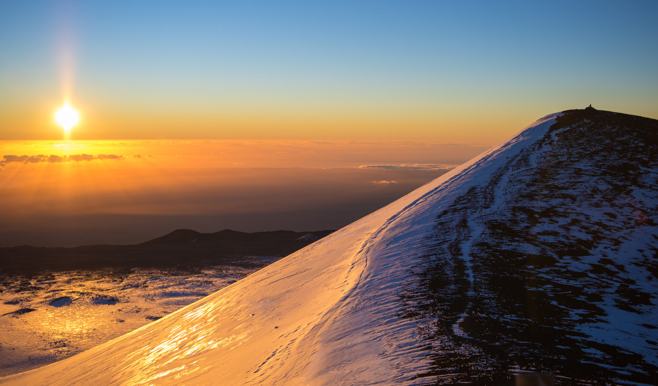
The sunset visit pattern. The most popular Mauna Kea experience timing: arrive at the VIS approximately 2 hours before sunset for required acclimatization. Drive (or be driven) to the summit approximately 30-45 minutes before sunset. Experience sunset from the summit (one of the world’s most dramatic sunset experiences — watching the sun set into the Pacific from a 13,803-foot summit with the curve of the earth visible). Descend before full dark — driving the Access Road in complete darkness is more challenging. Many tour operators combine the sunset summit visit with post-sunset stargazing at the VIS, where the public telescopes provide spectacular Milky Way and planetary viewing.
Summit weather realities — substantially worse than the lower mountain. Mauna Kea’s summit weather is genuinely severe even in Hawaiʻi: average summit temperatures are 30-40°F (-1°C to 4°C) in summer, often dropping below freezing at night even in July-August. Winter summit temperatures can fall to 10°F (-12°C) or below. Wind speeds regularly 30-50 mph; gusts to 80+ mph in storms. UV exposure is among the most extreme in the United States due to high altitude, low atmospheric protection, and tropical sun angle. Visibility can drop to under 10m in cloud or fog cover. The mountain has caused multiple visitor deaths from altitude-related events, cardiac events on the steep upper road, and exposure incidents. Take summit weather seriously regardless of the temperature in Hilo or Kona — the summit can be 50°F (28°C) colder than sea level on the same day.
Essential Gear Checklist
Mauna Kea’s gear requirements catch most visitors off-guard — the gap between tropical Hilo or Kona at sea level and the freezing summit at 13,803 ft is dramatic. Standard Hawaiʻi tourist attire (shorts, t-shirts, sandals) is completely inadequate for summit visits. Major tour operators include warm gear in their packages specifically because most visitors arrive without it.
Vehicle Visit Essentials
- Heavy fleece or insulated jacket (winter-weight)
- Long pants (not shorts) — wind protection essential
- Closed-toe shoes (not sandals)
- Warm hat or beanie
- Light gloves for sunset/post-sunset
- Sunglasses (Category 3-4 — UV is extreme)
- Sunscreen (SPF 50+) — even for late-day visits
- Water (1+ liter per person)
- Light snacks (altitude tip: eat before symptoms)
- Camera with appropriate batteries
Humuʻula Trail Hiking Kit
- Sturdy hiking boots with ankle support
- Hiking pants (long; sun + wind protection)
- Layered upper body: base layer + fleece + windshell
- Hardshell rain jacket (light but functional)
- Warm hat + insulated gloves
- Wide-brim sun hat for lower trail
- Sunglasses (Category 3-4)
- Heavy sunscreen + lip balm with SPF
- Trekking poles (highly recommended for descent)
- 30-40L daypack
- Water: 1.5 gallons / 5.5 liters per person
- Electrolyte tablets
- 2,500-3,500 calories of energy food
- Headlamp + spare batteries (insurance against late return)
- First aid kit (basic)
- Trash bags (pack out everything)
Winter / Storm Conditions
- Full winter mountaineering clothing system
- Insulated mountaineering boots
- Microspikes minimum; crampons for hard snow
- Heavier insulating jacket (down or synthetic)
- Goggles in addition to sunglasses
- Mittens + glove liner combo
- Gaiters
- Hand warmers / chemical heat packs
- Emergency bivvy or shelter
- Avalanche awareness for less-traveled routes
- Substantially more water + food than summer
Cultural Sensitivity Items
- Quiet voice / no loud music on the mountain
- Respect for any active ceremonies — observe at distance, do not photograph
- Stay on established trails (cultural sites visible from trails)
- Do not enter Lake Waiau or throw items into the lake
- Do not touch ahu (shrines) or other cultural features
- Do not climb on cinder cones (especially Puʻu Waiau)
- Pack out all trash — no rubbish bins
- Pre-trip cultural reading (recommended): “Born of the Land” and related Native Hawaiian source materials about Mauna a Wākea
Difficulty & What Mauna Kea Actually Demands
Mauna Kea’s “drive to the top” reputation creates a fundamentally misleading picture of what the mountain demands. The actual challenges are altitude, weather, cultural sensitivity, and the genuine complexity of visiting a sacred site at high altitude in the middle of an active management transition. Five specific characteristics define what the mountain actually requires:
1. The altitude is real — and substantially under-appreciated. Mauna Kea’s 4,207m summit is roughly equivalent to Mont Blanc’s lower flanks or Mount Whitney’s middle elevations. Approximately 30-40% of visitors who go to the summit experience meaningful altitude sickness (AMS) symptoms — headache, nausea, dizziness, fatigue. The unusual feature is the rapidity of the altitude gain — Hilo at sea level to summit at 13,803 ft in approximately 90 minutes is one of the fastest altitude gains accessible to ordinary visitors anywhere in the world. The 30-minute mandatory VIS stop is widely considered the absolute minimum; 60-90 minutes at VIS substantially improves outcomes. Children under 13, pregnant visitors, and those with cardiac or respiratory conditions are explicitly advised not to proceed above the VIS. Even for healthy adults, this is a genuine altitude experience, not a casual viewpoint visit.
2. The Access Road is more demanding than it looks — and brake fires are a documented hazard. The Mauna Kea Access Road climbs 4,600 vertical feet from the VIS to the summit in approximately 8 miles. The grade is steep and sustained; the upper paved section is heavily switchbacked; the lower gravel section requires confident 4WD/AWD driving. Vehicle brake fires from overheated brakes during descent are a documented hazard — multiple incidents per year. Use engine braking (low gear) for the entire descent. Stop at the VIS to allow brakes to cool. The 4WD-only rule above the VIS exists for vehicle safety, not just road conditions — 2WD vehicles cannot adequately handle the descent grade. Driving the road requires substantively more vehicle skill than typical tourist driving — many first-time visitors find the upper road genuinely intimidating.
3. The cultural-sensitivity reality is part of the climbing experience. Mauna Kea is unique among major US peaks in being an actively sacred site where ceremonies still occur regularly. This is not historical “former sacred site” framing — Native Hawaiian cultural practitioners visit, pray, and conduct ceremonies at the summit and at Lake Waiau today. The 2014-2019 TMT protests and the broader kiaʻi mauna movement reflect ongoing community concern about how visitors interact with sacred land. Visitors who treat Mauna Kea as a casual drive-up viewpoint or who behave disrespectfully on the mountain contribute directly to the cultural tensions the 2022 MKSOA transition is trying to address. The appropriate visitor posture is reverence, curiosity, and respect — not “I conquered Mauna Kea.” Stay on established trails, respect any active ceremonies, do not enter Lake Waiau, do not climb cinder cones, do not photograph ceremonial activities. Pre-trip cultural education is genuinely worth the time.
4. Summit weather is severe and tropical Hawaii intuitions don’t apply. The 50°F (28°C) temperature gap between sea-level Hilo or Kona and the summit catches most visitors completely off-guard. Summer summit temperatures often drop below freezing at night even in July-August. Winter summit can reach 10°F (-12°C). Wind speeds regularly 30-50 mph; gusts to 80+ mph in storms. UV exposure is among the most extreme in the United States. Standard Hawaiʻi tourist attire — shorts, t-shirts, sandals — is completely inadequate and visitors arriving in such clothing may be turned back by rangers or simply unable to remain comfortably at the summit. Major tour operators include warm gear because most visitors don’t pack for these conditions. Self-driving visitors must pack appropriately.
5. The management framework is changing — current rules may not match prior published information. The 2023-2028 MKSOA transition is reshaping Mauna Kea visitor management in real time. New rules emerge periodically; some prior tour packages and visitor activities may not be available. The TMT controversy continues to affect summit access during certain ceremonial dates and protest periods. Pre-trip verification of current rules is essential — check the Office of Maunakea Stewardship (hilo.hawaii.edu/maunakea), the MKSOA site (dlnr.hawaii.gov/maunakea-authority), and your tour operator within a week of your visit. Self-driving visitors should call the VIS the day before to confirm current Access Road status and any temporary closures.
What Mauna Kea rewards: Visitors with prior altitude experience or with adequate acclimatization time; appropriate clothing for the genuine summit cold; willingness to follow the strict 4WD-and-acclimatization protocols; genuine curiosity about Native Hawaiian culture and history; respect for the active sacred status of the mountain; flexibility about timing (sunset, stargazing, ceremonial-day closures); and a “visiting” rather than “conquering” mindset. As standalone “state high point” goal, Mauna Kea ticks the Hawaiʻi box and provides a meaningful 4,207m altitude experience. As “world’s tallest mountain from base to peak” claim, the framing is geologically genuine even though the experience involves only the above-sea-level portion. As cultural visit, it’s among the most significant Indigenous-sacred-mountain experiences accessible to ordinary US travelers — comparable in significance to visiting Mount Kailash in Tibet, though substantially more accessible logistically. As “a casual scenic drive” — no, this is not that. Mauna a Wākea demands more than that, and rewards visitors who give more than that.
Featured Mauna Kea Tour Operators
The majority of Mauna Kea visitors use guided tour operators rather than self-driving — driven by the 4WD requirement, the rental car prohibition, the brake-management challenge, the acclimatization protocol, and the cultural-context value that experienced guides provide. Below are the established Mauna Kea tour operators in 2026.
Hawaii Forest & Trail
The major Mauna Kea tour operator on the Big Island, with substantial experience and strong reputation for cultural context and ranger-aligned protocols. Offers sunset and stargazing programs from both Hilo and Kona/Waikoloa sides. Includes warm clothing, dinner, professional telescope viewing at the VIS. Adds substantial Native Hawaiian cultural and astronomical interpretation. Most-reviewed Mauna Kea tour operator on TripAdvisor and similar review sites. hawaiiforest.com/mauna-kea
Mauna Kea Summit Adventures
The other major Mauna Kea-focused operator. Established sunset and stargazing summit programs with similar inclusions and quality. Often considered the alternative reliable option to Hawaii Forest & Trail. Pickup from Kona and Waikoloa resort areas. maunakeasummitadventures.com
Arnott’s Lodge Hiking Adventures
Hilo-based budget-friendly operator that offers guided Mauna Kea visits alongside other Big Island hiking programs. Different price point and program structure from the major operators; appeals to budget-conscious visitors and longer-stay travelers. arnottslodge.com
Kamaʻāina Observatory Experience
Not a commercial operator — a public program for Hawaiʻi residents only. Monthly small-group summit observatory tours with advance registration. Returned in 2025 after a hiatus. Provides interior observatory access not available to general tour participants. Hawaiʻi resident ID required. Check the Office of Maunakea Stewardship site for current schedule and registration. (Listed here for completeness; visitors should not expect access unless they are Hawaiʻi residents.)
Maunakea Summit and Stars Giveback Experience
A 2025-era stewardship-oriented program that combines summit access with conservation activities — native seed collection, interpretive cultural guiding, summit sunset, and post-sunset stargazing. Emphasizes “giveback” framing where visitors contribute to mountain stewardship rather than just consuming the experience. Limited availability; check current schedules. Represents the broader 2024-2026 trend toward stewardship-framed visitor programs.
Self-Drive with Harper Car & Truck Rental
Not a guide service, but the standard option for self-drive Mauna Kea visits. Harper Car & Truck Rental in Hilo is the primary Big Island operator that explicitly permits Mauna Kea Access Road driving in their 4WD vehicles. Other major rental companies (Hertz, Enterprise, Budget, etc.) prohibit Access Road driving in their contracts. Harper’s 4WD vehicles include the required clearance and capability. harpershawaii.com
Frequently Asked Questions
Mauna Kea — properly Mauna a Wākea — rises to 4,207 meters (13,803 feet) on the Big Island of Hawaiʻi. It is the highest point in the Hawaiian Islands, the highest point in the State of Hawaii, and the 6th-highest US state high point. However, measured from its base on the Pacific Ocean seafloor at approximately -5,950m, Mauna Kea reaches a total height of 10,210 meters (33,500 feet) — making it the tallest mountain in the world from base to peak, exceeding Mount Everest’s base-to-summit measurement by approximately 1,200 meters (4,000 feet). The mountain is a dormant shield volcano with its last eruption approximately 4,500 years ago. Mauna Kea is the second-highest island peak in the world after New Guinea’s higher summits. Coordinates: 19.8207°N, 155.4680°W.
Mauna Kea is the most sacred place in Hawaiian religion — Mauna a Wākea, the firstborn child of sky father Wākea and earth mother Papahānaumoku in Hawaiian cosmology. The mountain is the piko (umbilical cord) of the Hawaiian people, connecting earth, sky, and the spirit realm. In ancient Hawaiian tradition, the summit was wao akua — the “realm of the gods” — restricted by kapu (ancient sacred law) to high-ranking aliʻi and kahuna. The snow goddess Poliʻahu was said to dwell on the upper slopes. Lake Waiau, a small alpine lake at 13,020 feet, holds particular significance — Hawaiian families historically and still today bring the piko of newborn children to the lake. The Adze Quarry near the summit is the largest pre-contact stone tool quarry in the Pacific. Climbers visit a mountain that remains actively sacred — ceremonies still occur regularly at the summit and at Lake Waiau. Many Native Hawaiian community members prefer the language of visiting or approaching the summit rather than “climbing” or “conquering” it.
The first recorded ascent of Mauna Kea by a non-Hawaiian was made on 14 August 1823 by Joseph F. Goodrich, an American missionary, accompanied by Hawaiian guides whose names are not preserved in the written record. However, the actual first human ascents of Mauna Kea long predate Goodrich — Native Hawaiian Kānaka Maoli had been visiting and climbing the summit for at least 700-900 years before European arrival, with archaeological evidence including the substantial Mauna Kea Adze Quarry near the summit. The Adze Quarry shows continuous use from approximately 1100 CE onward. The summit was visited regularly by aliʻi (chiefs), kahuna (priests), and toolmakers as part of established religious and economic practice. King Kalākaua famously visited the summit in 1881 during a royal tour of the mountain. The “first ascent” framing is itself an artifact of the European exploration tradition.
The Thirty Meter Telescope (TMT) controversy is the ongoing conflict over the proposed construction of a $1.4 billion 30-meter optical telescope on Mauna Kea’s summit. Native Hawaiian opposition began locally on 7 October 2014 with the construction groundbreaking, became internationally visible after the 2 April 2015 arrest of 31 protectors blockading the Mauna Kea Access Road, and reached peak intensity in July 2019 when thousands of protectors (called kiaʻi mauna, “mountain protectors”) blockaded the Access Road for months. The movement operates under the principle of kapu aloha — sacred non-violent resistance grounded in love and traditional Hawaiian values. The controversy is not primarily about astronomy itself but about (1) the cumulative impact of 13+ existing telescopes on a sacred summit, (2) inadequate Native Hawaiian consultation and consent, (3) the broader pattern of colonial-era land management, and (4) the question of who has standing to make decisions about sacred land. The TMT project’s status remains legally contested as of 2026. The 2022 Act 255 establishing the MKSOA was a direct response to the 2019 protests.
The Mauna Kea Stewardship and Oversight Authority (MKSOA) is the new state agency created by Hawaii’s Act 255 of 2022 — signed by Governor David Ige in July 2022 — to assume management of Mauna Kea from the University of Hawaiʻi. The MKSOA was established 1 July 2022, with board authority beginning 1 July 2023. A five-year joint management transition period runs from 1 July 2023 through 1 July 2028, during which UH’s Center for Maunakea Stewardship continues daily operations while MKSOA assumes governance authority. The UH master lease covering the Mauna Kea Science Reserve expires 31 December 2033. MKSOA was created in direct response to the 2014-2019 TMT protests. The authority’s voting membership includes Native Hawaiian cultural practitioners — a structural change from the prior UH/DLNR management model.
There are two principal access routes. (1) The Mauna Kea Access Road — the standard motorized route from Daniel K. Inouye Highway (Saddle Road) at mile marker 28. Visitors ascend by 4WD/AWD vehicle from the Maunakea Visitor Information Station (9,200 ft) to the summit at 13,803 ft. Mandatory 30-minute acclimatization at the VIS. 2WD vehicles strictly prohibited above the VIS. (2) The Humuʻula Trail — the standard hiking route, 21 km / 13.1 miles round trip with approximately 1,400m / 4,600 ft elevation gain. 8-10 hours round trip for fit hikers. Class 1 hiking on volcanic cinder. Hikers must register at the VIS before and after hiking. The trail passes Lake Waiau at 13,020 ft.
No formal permit is required and there is no entrance fee. However, practical requirements apply: (1) Mandatory acclimatization stop of at least 30 minutes at the Visitor Information Station (9,200 ft) — enforced by rangers. (2) 4WD/AWD vehicles required above the VIS — strictly enforced. (3) Hikers must register at the VIS before and after hiking the Humuʻula Trail. (4) Groups larger than 10 require advance permission. (5) Children under 13 should not go above the VIS. (6) Pregnant visitors and those with heart or respiratory conditions are advised not to go higher than the VIS. (7) 24-hour rule after scuba diving — no ascent above the VIS within 24 hours of scuba diving. MKSOA is currently developing new visitor management policies that may modify these requirements; check the Office of Maunakea Stewardship for current rules.
Yes — measured from base to peak, Mauna Kea is the tallest mountain in the world. The mountain’s base sits on the Pacific Ocean seafloor at approximately -5,950m, and its summit reaches +4,207m above sea level. Total base-to-peak height: approximately 10,210m (33,500 ft) — exceeding Mount Everest’s base-to-summit measurement of approximately 9,000m (29,500 ft) by 1,200m (4,000 ft). However, Mount Everest remains the highest point on Earth measured above sea level (8,849m vs Mauna Kea’s 4,207m). The two records are different measurements of “tallness” — Everest is the highest summit, Mauna Kea is the tallest mountain. The base-to-peak fact is one of the mountain’s most famous distinctions but is geologically secondary to the practical climbing reality: visitors experience the above-sea-level 4,207m portion of the mountain.
Mauna Kea is accessible year-round, but conditions vary substantially. Optimal visiting windows: (1) Best stargazing — September through November and March through May, with the lowest humidity and clearest skies. (2) Best for hiking the Humuʻula Trail — April through October. (3) Avoid — December through March can bring winter storms with snow, ice on the Access Road, and closures (15-25 days/year average). The summit averages 280-300+ clear nights per year. Daily timing matters greatly: sunset visits are the most popular (1-2 hours before sunset arrival at the VIS for acclimatization). For hikers, very early starts (5-7 AM trailhead departure) are essential. The lower mountain (VIS at 9,200 ft) is accessible year-round in 2WD vehicles; the upper mountain requires 4WD/AWD and current road condition checks.
Mauna Kea Map & Hilo Weather
Mauna Kea summit coordinates: 19°49’14″N 155°28’05″W (19.8207°N, -155.4680°W). The map below shows the summit’s position on Hawaiʻi Island. Live weather is shown for Hilo (sea level) — the main eastern Big Island service town. Summit conditions are typically 50-55°F (28-30°C) colder than Hilo due to the 13,803-foot elevation gain.
Summit Access & Logistics: Vehicles, Fuel & Acclimation
Was this helpful?
🏔Related peaks nearby
🧭Explore & compare
Global Summit Guide is an independent mountaineering resource founded in 2026. The team combines first-hand trekking and climbing experience with in-depth research and professional health and nutrition review to help climbers choose objectives, prepare properly, and stay safe.
Health, altitude, and nutrition content is reviewed by Taylor Ludlow (Registered Nurse) and Brigg Hoopes (Nutritionist).
What We Don't Know Yet
Mountain information changes quickly. This box explains the limits of what this page can responsibly promise.
- Weather, snowpack, avalanche risk, road access, and route conditions can change quickly and may be different on your climbing dates.
- Route conditions, trailhead access, crevasse exposure, stream crossings, and rescue access may vary from published planning guidance.
- Visa, passport, vaccination, border, insurance, and local transportation rules may change before your trip.
Verify current conditions with official land managers, guide services, local forecasts, and current route reports before booking or climbing.
Mountaineering, rock and ice climbing, glacier travel, and high-altitude activity are inherently dangerous and can result in serious injury or death. The information on Global Summit Guide is provided for general informational and educational purposes only and is not a substitute for professional instruction, qualified guiding, proper equipment, or your own judgment and experience.
Route conditions, weather, snowpack, permits, regulations, and hazards change constantly and may differ from what is described here. Details may be incomplete, out of date, or contain errors. Always verify current information with local authorities, certified guides, and official sources before making any decision in the mountains.
Nothing on this site is medical, legal, or financial advice. Our fitness, acclimatization, altitude, and nutrition content is general in nature; consult a qualified physician before beginning any strenuous exercise program or exposing yourself to high altitude.
You are solely responsible for your own safety and decisions. To the fullest extent permitted by law, Global Summit Guide and its team accept no liability for any loss, injury, damage, or expense arising from use of, or reliance on, this information. By using this site you acknowledge these risks and accept these terms.
Some links on this site may be affiliate links. If you buy through them we may earn a small commission at no extra cost to you; this never affects our recommendations.
Global Summit Guide recommendation path
Next Best Mountain to Research
Use these recommendations to continue the right planning path instead of stopping on one page.
Use current permit, weather, route, and operator information before booking or climbing.