
Last updated July 11, 2026
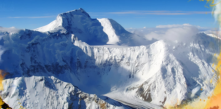
Climbing Peak Korzhenevskaya (Peak Ozodi): A Pamir Snow Leopard 7,000er
The third-highest peak in the Pamirs and one of the five Soviet “Snow Leopard” summits — and the most popular gateway to 7,000 m climbing in Tajikistan. Renamed Peak Ozodi (“Freedom”) in 2020, it pairs a moderate Russian 4B grade with a sharp 40-metre rock step, all reached by helicopter into the remote Moskvina base camp.
Peak Korzhenevskaya (7,105 m) — officially Peak Ozodi since 2020 — is the most popular first 7,000 m peak in the Pamirs, and for good reason: a moderate Russian 4B grade, a well-run shared base camp, and a logical pairing with neighbouring Ismoil Somoni. But “gateway” doesn’t mean easy. The route has a real 40-metre near-vertical rock step you climb on fixed ropes with jumars, and 7,105 m in the remote Pamir is a serious, committing expedition.
Come with prior altitude above 5,000–6,000 m, solid glacier and fixed-rope skills, and 18–21 days. Rescue is helicopter-dependent and limited above ~5,800 m, so self-reliance and real insurance matter. Get that right and it’s one of the great, uncrowded high-altitude climbs on Earth.
On this page
Where it is
Central Pamir, Tajikistan — 13 km north of Ismoil Somoni, reached only by helicopter.
Peak Korzhenevskaya anchors the northwest fork of the Academy of Sciences Range, the spine of the Pamirs, on the south bank of the Muksu River. It sits 13 km north of Ismoil Somoni Peak (7,495 m), the two sharing the Moskvina Base Camp at ~4,360 m. Note a common misconception: the peak lies just west of the Gorno-Badakhshan (GBAO) boundary, in Jirgatol district — not deep inside GBAO — though access still runs through the border-permit system. The only practical approach is a helicopter from Jirgatal village.
The peak, in brief
Third-highest in the Pamirs — and the friendliest of Tajikistan’s giants.
At 7,105 m (23,310 ft), Korzhenevskaya is the third-highest peak in both the Pamirs and Tajikistan, after Ismoil Somoni (7,495 m) and Ibn Sina/Lenin (7,134 m), and the fourth-highest in the entire former Soviet Union. It’s one of the five Snow Leopard peaks, and after Lenin/Ibn Sina it’s the second-most-climbed major Pamir summit — the shared Moskvina base camp and helicopter access are what make that possible. Russian geographer Nikolai Korzhenevsky discovered it in 1910 and named it for his wife Evgenia; in 2020 Tajikistan renamed it Peak Ozodi (“Freedom”), though most climbers still say Korzhenevskaya.
The Snow Leopard context
One of five peaks in the classic Soviet high-altitude challenge.
The Snow Leopard Award honours climbers who summit all five 7,000 m peaks in the former USSR. Korzhenevskaya is the usual second step — after Lenin/Ibn Sina — and prime preparation for the harder Ismoil Somoni next door:
| Snow Leopard peak | Elevation | Location | Character |
|---|---|---|---|
| Ismoil Somoni (Communism) | 7,495 m | Tajikistan | Highest & hardest of the five; technical 5A |
| Jengish Chokusu (Pobeda) | 7,439 m | Kyrgyzstan | Most technical and dangerous; 6A |
| Ibn Sina (Lenin) | 7,134 m | Kyrgyzstan/Tajikistan | Most accessible; the usual first 7,000er |
| Korzhenevskaya (Ozodi) | 7,105 m | Tajikistan | Pamir gateway; 4B; second-most-climbed |
| Khan Tengri | 7,010 m | Kazakhstan/Kyrgyzstan | The marble pyramid; 5A; most aesthetic |
The South Ridge route
The modern standard — about 85% of climbers — from Moskvina to the summit ridge.
South Ridge via the Moskvin Glacier
The route climbs in stages with three camps above base, using the long expedition timeline to acclimatize. It’s slightly more technical than Lenin’s standard route but with a shorter summit day. The stages:
| Moskvina BC (4,360 m) → Camp 1 (~5,300 m) | Moraine and short scree along a long lateral moraine beside the glacier. |
| Camp 1 → Camp 2 (~5,800–6,100 m) | Glacier with occasional fixed ropes to the foot of the south-west face; an intermediate acclimatization camp. |
| The 40 m rock step (60–80°) | The technical crux — a near-vertical fixed-rope pitch that demands confident jumar/ascender work at altitude. It gates access to the upper plateau. |
| → Camp 3 (~6,400 m) | A large snow plateau above the rock step; the launch camp for the summit. |
| Camp 3 → summit (7,105 m) | A long, moderate-angle but narrow and exposed ridge — straightforward in good weather, serious in bad. |
Other routes
Historic and technical lines for independent expeditions.
| Route | Grade | For |
|---|---|---|
| South Ridge (standard) | Russian 4B | The commercial line; ~85% of climbers |
| North Ridge (Ugarov) | Russian 5A | The 1953 first-ascent line; historic, rarely climbed now |
| Western Face | Russian 5A | Several technical variations; private expeditions |
| Northeast Ridge | Russian 5B | Sustained and technical; elite teams only |
Access & permits (2026)
A road to Jirgatal, then the only way in: a helicopter.
The chain is Dushanbe → Jirgatal (Lakhsh) by road (6–8 hours), then a ~30-minute helicopter to Moskvina Base Camp. The historic multi-day glacier approach is no longer used. Build in reserve days — flights are weather-dependent and can slip for days.
- Tajikistan visa (e-Visa at evisa.tj), ~$50–80.
- Border Zone Permit (~$30–50) — the peak is near the Kyrgyz border; a GBAO permit is often arranged too, since it sits right at the GBAO boundary.
- OVIR registration within a few days of arrival, plus an environmental fee.
- Helicopter charter Jirgatal ↔ Moskvina, ~$500–800, with a 25–35 kg cargo allowance ($5/kg over).
- Insurance covering high-altitude rescue and helicopter evacuation to 7,500 m — standard travel policies exclude climbing above 4,000 m.
Cost in 2026
One of the more affordable 7,000ers — especially paired with Somoni.
| Option | 2026 price | Best for |
|---|---|---|
| Self-guided logistics | from USD $2,200 | Experienced parties; permits + helicopter + base-camp services only |
| European guided (e.g. 18-day) | EUR 2,200–3,200 | Guided ascent, mini-group, August dates |
| Modular Central Asian | ~USD $3,500–5,000 | Guide fee + daily rate + summit-push charge; customizable |
| Premium Western-led | from £4,500 / €4,500–6,500 | Full-service, small ratios, Western leader + local guides |
| Combined with Ismoil Somoni | USD $5,000–7,000 | 28–35 days, two 7,000ers, shared base camp |
Packages typically bundle permits, the Jirgatal helicopter, base-camp services, fixed ropes, and rescue registration. Budget separately for international flights (Turkish Airlines, flydubai, Somon Air; ~€500–900 from Europe) and insurance.
Weather & season
A six-week Pamir summer window — and a summit far colder than base camp.
The season is short: roughly July 15 – August 25, with late July to mid-August the prime window for stable weather and full base-camp and helicopter operations. The 1953 first ascent fell on August 22, so late August can still deliver. Outside this window the sharp continental Pamir climate turns brutal — deep snow, extreme cold, high winds — and effectively unclimbable. The live forecast below is for Moskvina Base Camp and refreshes on load.
Moskvina Base Camp (~4,360 m)
Loading live data…Gear essentials
Full 7,000 m expedition kit — with a jumar for the rock step.
- Boots & hardware: B3 double boots rated to at least −25°C, 12-point steel crampons, ice axe, and a jumar/ascender (mandatory for the rock step) plus harness, locking carabiners, descender, and slings.
- Insulation: an expedition down suit (or heavy down jacket + pants), 800-fill or higher — the continental Pamir is bitterly cold despite the “moderate” altitude.
- Sleep system: down bag rated to ~−30°C with a vapour-barrier liner; insulated sleeping pad.
- Head & hands: Category 4 glacier glasses plus ski goggles, balaclava, insulated mittens and backup gloves.
- Rest: 70L pack + summit daypack, two headlamps, insulated bottles/thermos (no bladders — they freeze), a satellite communicator, Diamox, and personal meds.
The main hazards
Moderate grade, serious mountain — respect the altitude and the isolation.
| Hazard | Why it matters & how to manage it |
|---|---|
| Altitude illness (7,000 m+) | HAPE/HACE are real above 6,000 m. Use the three-camp acclimatization, carry Diamox/dexamethasone, and monitor symptoms honestly. |
| Helicopter-limited rescue | Helicopters can’t operate reliably above ~5,800 m, so above the rock step you’re largely self-reliant. Insurance and self-rescue skill are essential. |
| The 40 m rock step | Fixed-rope, near-vertical — needs confident jumar technique at altitude. Check the fixed ropes; don’t trust old cord blindly. |
| Continental Pamir weather | Rapid change and winds over 100 km/h in a short season; hard turnaround times on the exposed summit ridge. |
| Crevasses on the approach | Roped glacier travel; retreating ice keeps exposing new hazards. |
Name & history
A geographer’s tribute to his wife — and a 17-year road to the summit.
Russian geographer Nikolai Korzhenevsky discovered the peak in August 1910 while following the Muksu River, and named it for his wife, Evgenia Sergeevna Korzhenevskaya — an educator who joined his scientific expeditions and once climbed Vesuvius with him. The name reached official maps by 1927. Evgenia lived to see her peak immortalized, dying in Tashkent in 1969 at 88.
The summit resisted for decades. Attempts in 1936 (Dzhaparidze and Gusak) and 1937 failed, the latter camping some 700 m too low; the Second World War then paused Soviet mountaineering entirely. The first ascent finally came on 22 August 1953, when an eight-man Leningrad team led by Alexei Ugarov climbed the North Ridge from the Korzhenevsky Glacier — the third of the USSR’s 7,000ers to be climbed, after Lenin and Stalin (now Ismoil Somoni). Since then the South Ridge has become the standard commercial line, and in 2020 the peak took its modern Tajik name, Ozodi.
Frequently asked questions
How high and how hard is it?
7,105 m — third-highest in the Pamirs. The South Ridge is Russian 4B: moderate for a 7,000er, but with a 40 m near-vertical fixed-rope rock step and all the seriousness of high altitude in a remote range. An excellent first 7,000er for experienced climbers, not a walk-up.
Why is it called Peak Ozodi now?
Tajikistan renamed it in 2020 — “Ozodi” means Freedom — to mark its sovereignty, part of a wider post-Soviet renaming. Most climbers and operators still use Korzhenevskaya, so you’ll see both.
What’s the standard route?
The South Ridge from Moskvina Base Camp (4,360 m): moraine to Camp 1 (~5,300 m), glacier to Camp 2 (~5,800–6,100 m), the 40 m rock step, Camp 3 (~6,400 m), then the summit ridge to 7,105 m. About 85% of climbers, over 18–21 days.
How do you get there and what permits are needed?
Dushanbe → Jirgatal by road, then helicopter to Moskvina. You need a Tajik visa, a Border Zone Permit, OVIR registration, and an environmental fee (a GBAO permit is often arranged too). Operators handle it; allow a month’s lead time.
How much does it cost?
From ~USD $2,200 self-guided up to €4,500–6,500 premium; combined with Ismoil Somoni, ~$5,000–7,000 for 28–35 days. Flights and insurance extra.
When should I go?
July 15–August 25, prime late July to mid-August. Outside that six-week window the Pamir is effectively unclimbable and helicopters stop flying.
How we built this
Research-based. This guide draws on licensed Central Asian operator programs, standard Pamir route references, and geographic sources, cross-checked for elevation, route, permits, and season. We corrected two points some sources get wrong: the peak sits just west of the GBAO boundary in Jirgatol district (not inside GBAO), and its coordinates are about 39.05°N, 72.02°E. The 2020 renaming to Peak Ozodi is confirmed.
Permits, helicopter logistics, and operator pricing change between seasons. Confirm current details with a licensed Tajik operator and check a high-altitude forecast before any attempt.
Climb your first Pamir 7,000er — the right way
Peak Korzhenevskaya rewards prepared climbers: prior 5,000–6,000 m experience, solid fixed-rope and glacier skills, 18–21 days, and real high-altitude insurance. Pair it with Ismoil Somoni and you’ve got two Snow Leopard peaks from one Pamir base camp.
Pair with Ismoil Somoni →Fixed lines & jumars →Was this helpful?
🏔Related peaks nearby
🧭Explore & compare
Global Summit Guide is an independent mountaineering resource founded in 2026. The team combines first-hand trekking and climbing experience with in-depth research and professional health and nutrition review to help climbers choose objectives, prepare properly, and stay safe.
Health, altitude, and nutrition content is reviewed by Taylor Ludlow (Registered Nurse) and Brigg Hoopes (Nutritionist).
What We Don't Know Yet
Mountain information changes quickly. This box explains the limits of what this page can responsibly promise.
- Route conditions, snowpack, closures, and weather can change quickly after this page is updated.
- Permit rules, fees, quotas, and reservation windows may change between review cycles.
- Operator availability, pricing, guide ratios, and cancellation terms can change by season.
- Your fitness, altitude response, risk tolerance, and experience level may change what is safe or realistic.
- Use this page for planning guidance, then verify current information with official sources and qualified local experts before committing.
Verify current conditions with official land managers, guide services, local forecasts, and current route reports before booking or climbing.
Mountaineering, rock and ice climbing, glacier travel, and high-altitude activity are inherently dangerous and can result in serious injury or death. The information on Global Summit Guide is provided for general informational and educational purposes only and is not a substitute for professional instruction, qualified guiding, proper equipment, or your own judgment and experience.
Route conditions, weather, snowpack, permits, regulations, and hazards change constantly and may differ from what is described here. Details may be incomplete, out of date, or contain errors. Always verify current information with local authorities, certified guides, and official sources before making any decision in the mountains.
Nothing on this site is medical, legal, or financial advice. Our fitness, acclimatization, altitude, and nutrition content is general in nature; consult a qualified physician before beginning any strenuous exercise program or exposing yourself to high altitude.
You are solely responsible for your own safety and decisions. To the fullest extent permitted by law, Global Summit Guide and its team accept no liability for any loss, injury, damage, or expense arising from use of, or reliance on, this information. By using this site you acknowledge these risks and accept these terms.
Some links on this site may be affiliate links. If you buy through them we may earn a small commission at no extra cost to you; this never affects our recommendations.
Global Summit Guide recommendation path
Next Best Mountain to Research
Use these recommendations to continue the right planning path instead of stopping on one page.
Use current permit, weather, route, and operator information before booking or climbing.
Search Flights, Hotels & Rental Cars
Have the mountain or destination picked? Use Expedia to compare the flights, lodging and rental cars that fit your actual trip dates. For mountain travel, consider arriving early enough for delays and adding a buffer night after the climb before a fixed flight home.
Compare current flight, hotel and car options.
Affiliate disclosure: Global Summit Guide may earn a commission if you book through this link, at no additional cost to you.