
Last updated April 23, 2026
Climbing Jengish Chokusu / Pobeda Peak: The Complete 2026 Abalakov Route, Border Permit & Tien Shan Victory Peak Guide
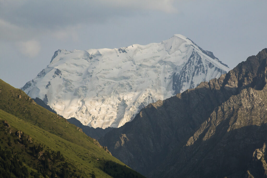
Jengish Chokusu rises to 7,439 meters (24,406 ft) on the Kyrgyzstan-China border in the Kakshaal-Too Range. Specifically, this peak stands as the highest mountain in the entire Tien Shan system and the highest point in Kyrgyzstan. Additionally, it ranks as the 16th most prominent peak on Earth and represents the ultimate Snow Leopard Challenge summit.
The official Kyrgyz name Jengish Chokusu translates to “Victory Peak.” Moreover, Russians call it Pik Pobedy or Pobeda Peak — the same meaning honoring Red Army triumph. Importantly, the Chinese know it as Tömür or Tomur Feng from the Uyghur word meaning “Iron.” Furthermore, legendary alpinist Vitaly Abalakov named the peak in 1956 honoring the Soviet victory in World War II.
Additionally, Pobeda holds a reputation as the most dangerous Snow Leopard peak. Specifically, over 80 climbers have died on the mountain since 1955 — and not a single body has ever been retrieved. Moreover, the 1955 disaster killed 11 of 12 Kazakh expedition members in a single blizzard at 6,900m. Consequently, Pobeda demands more respect and preparation than any other Central Asian objective.
Furthermore, Pobeda sits geographically only 16 kilometers southwest of Khan Tengri. Moreover, both peaks share the South Inylchek (Engilchek) Glacier for base camp logistics. Additionally, the Kakshaal-Too Range position adjacent to the Takla Makan desert creates violent weather patterns with winds reaching 120-150 km/h and temperatures below -30°C even during the climbing season. Importantly, Pobeda remains the coldest 7,000-meter peak on Earth.
Find Hotels, Flights & Trips for the World’s Best Hiking Destinations
The Global Summit Guide Travel Shop on Expedia — curated for outdoor adventurers, mountaineers, and serious hikers. Patagonia to the Alps. Nepal to the Rockies. Curated lodging for every region we cover.
Explore Travel Shop on Expedia →Ultimately, Pobeda Peak delivers the ultimate Central Asian high-altitude challenge. Specifically, the Classic West Ridge route via Dikij Pass and the Abalakov North Ridge each demand Russian grade 5B or 6A technical climbing. Additionally, the 12-kilometer summit ridge at over 7,000m creates an extended death zone exposure unmatched by any other 7,000m peak. Consequently, this guide covers everything needed for a safe, legal, and properly prepared 2026 Pobeda expedition.
(24,406 ft)
Kyrgyzstan highest
Apply 1 month ahead
Abalakov’s 30-day climb
Pobeda Peak Location & Summit Weather
Check live 7-day forecast conditions at the Pobeda summit (7,439m). Additionally, view the interactive terrain map showing Pobeda’s position in the Kakshaal-Too Range of eastern Kyrgyzstan on the Chinese border, 16 kilometers southwest of Khan Tengri.
Pobeda Peak · Kakshaal-Too Range
42.04°N, 80.13°ESummit Weather
Elev: 7,439 m · Summit −30 to −50°CPobeda Peak stands as the Tien Shan’s ultimate summit. Specifically, it combines the highest elevation in Central Asia’s northern mountain system with the most technically demanding and psychologically challenging routes. Additionally, the peak anchors the elite final objective in the Snow Leopard Challenge, drawing the world’s most experienced high-altitude mountaineers. Furthermore, its deadly reputation and 12-kilometer summit ridge create a climbing experience unmatched by any other 7,000-meter peak.
The peak rises to 7,439 meters (24,406 ft) in the Kakshaal-Too Range of eastern Kyrgyzstan. Moreover, the official Kyrgyz name Jengish Chokusu translates to “Victory Peak.” Notably, the 1943 Soviet ground surveys first identified Pobeda as the Tien Shan’s highest — previously climbers assumed Khan Tengri held that distinction. However, Pobeda’s remote position on the Kyrgyzstan-China border delayed its geographic recognition by decades.
Today’s climbers encounter dramatically varied terrain across both main routes. First, helicopter transport from Karkara meadow to South Inylchek Base Camp at 4,000m. Second, a 15-kilometer glacier approach via the Zvezdochka (Little Star) Glacier to Camp 1 at Dikij Pass (5,200m). Third, sustained fixed-rope climbing on icefalls, steep ice, and rocky ridges with snow-ice pitches. Fourth, the ascent to West Pobeda Peak at 6,918m. Finally, the crucial 12-kilometer summit ridge traverse to the East summit at 7,439m.
However, Pobeda Peak is an extreme alpine objective — not a trekking or standard mountaineering peak. Specifically, the standard 26-27 day program involves Russian grade 5B (Classic West Ridge) to 6A (Abalakov North Ridge) technical climbing with sustained steep ice, mixed climbing, and hurricane-force winds from the Takla Makan desert. Additionally, prior experience on Lenin Peak, Khan Tengri, or similar 7,000-meter peaks represents an essential prerequisite. Consequently, Pobeda should be attempted only as the final Snow Leopard objective.
Currently, a shared permit framework governs every ascent. Specifically, Kyrgyzstan abolished climbing permits years ago, but the Border Zone Permit (propusk) remains mandatory due to the Chinese frontier along the summit ridge. Additionally, the propusk costs approximately EUR 30 and requires passport details submitted at least one month before arrival. Furthermore, OVIR registration must be completed within 5 days of arrival in Kyrgyzstan. Consequently, booking through registered operators eliminates administrative uncertainty.
Most importantly, Pobeda Peak carries unparalleled historical and tragic significance. Specifically, the 1955 disaster killed 11 of 12 Kazakh climbers. Moreover, Vitaly Abalakov’s 1956 first ascent took 30 days and the team included Ural Usenov — sole survivor of the 1955 tragedy. Additionally, over 80 climbers have died here with zero bodies retrieved. Furthermore, the 2025 tragedy of Natalia Nagovitsina stranded at 7,100m for 15 days renewed international attention on Pobeda’s deadly nature. Ultimately, Pobeda remains the most demanding Snow Leopard peak.
Pobeda Peak uses the same base camp as Khan Tengri — South Inylchek (Engilchek) Glacier at 4,000m. Specifically, no climbing permit is required in Kyrgyzstan but the Border Zone Permit (propusk) costs approximately EUR 30 and requires passport details submitted at least one month before arrival. Additionally, OVIR registration at a local police station must be completed within 5 days of arrival. Moreover, licensed operators like Ak-Sai Travel, ClimberCA, Central Asia Travel, Pamir Expeditions, and Expeditions Unlimited handle all paperwork automatically. Furthermore, many climbers combine Khan Tengri with Pobeda in a single season using shared helicopter logistics from Karkara. Peak-season July-August slots fill fast — book at least 4-6 months ahead. See the 2026 Permit section for the complete walkthrough.
Pobeda has claimed over 80 climbers since 1955, with not a single body ever retrieved due to unstable terrain and continuous avalanche exposure. Specifically, the 1955 Kazakh disaster killed 11 of 12 expedition members in a single blizzard at 6,900m. Additionally, the 12-kilometer summit ridge creates an extended death zone traverse at over 7,000m. Moreover, injured climbers above 6,800m who cannot descend independently have virtually zero survival chances — the 2025 Natalia Nagovitsina tragedy exemplified this reality. Furthermore, winds from the Takla Makan desert routinely exceed 120-150 km/h with temperatures below -30°C. Consequently, Pobeda demands the most rigorous preparation of any commercial 7,000m objective.
All 2026 figures were verified against primary Central Asian operator documentation from Ak-Sai Travel, ClimberCA International Consortium, Central Asia Travel, Pamir Expeditions, Expeditions Unlimited, and Explore-Share IFMGA network. Additionally, historical context draws on Abalakov’s 1956 expedition report, the 1991 Soviet 1:50,000 topographic maps, Wikipedia’s comprehensive Pobeda article, and the Country Highpoints detailed route analysis. Furthermore, fatality records reference the ExplorersWeb tribute piece and the 2025 Nagovitsina tragedy coverage. Moreover, the 1955 disaster survivor account of Ural Usenov appears across multiple Soviet mountaineering archives. Fact-check: April 23, 2026.
Pobeda Peak at a Glance
Why Pobeda Peak Holds Legendary Status
The Tien Shan’s Highest Summit
Pobeda stands at 7,439 meters as the highest mountain in the entire Tien Shan system. Specifically, it ranks as the 16th most prominent peak on Earth. Additionally, the peak represents the highest point in Kyrgyzstan and Earth’s highest mountain north of 39° latitude. Moreover, Pobeda dominates the Kakshaal-Too Range adjacent to the Chinese border.
The Most Dangerous Snow Leopard Peak
Over 80 climbers have died on Pobeda since 1955 — with not a single body ever retrieved. Specifically, the 1955 Kazakh disaster killed 11 of 12 expedition members in a single blizzard. Moreover, the 12-kilometer summit ridge creates extended death zone exposure unmatched elsewhere. Consequently, Pobeda earns its reputation as the most dangerous 7,000-meter peak commonly attempted.
The Victory Peak Heritage
Vitaly Abalakov named the peak Pobeda (Victory) in 1956 honoring the Soviet triumph in World War II. Additionally, the 30-day first ascent involved 11 climbers and included Ural Usenov — sole survivor of the 1955 tragedy. Moreover, the Kyrgyz name Jengish Chokusu carries the same meaning. Furthermore, Chinese Tomur Feng translates as “Iron Peak” reflecting its forbidding character.
The Coldest 7,000m Peak on Earth
Pobeda’s position in the Kakshaal-Too Range creates extreme climatic conditions. Specifically, winds from the Takla Makan desert routinely exceed 120-150 km/h. Additionally, temperatures plunge below -30°C even during the brief climbing season. Moreover, the peak is typically obscured by thick cloud even during relatively good weather. Consequently, Pobeda is widely considered the coldest 7,000m peak.
Final Snow Leopard Challenge Peak
Pobeda represents the ultimate Snow Leopard objective — traditionally climbed after Lenin Peak, Korzhenevskaya, Ismail Samani, and Khan Tengri. Specifically, the challenge requires summits of all five 7,000m peaks in the former USSR. Additionally, Pobeda ranks as the most technical among these five. Furthermore, most Snow Leopard holders describe Pobeda as their most demanding alpine experience.
The 12-Kilometer Summit Ridge
Pobeda’s 12-kilometer summit ridge creates the longest sustained high-altitude traverse of any 7,000m peak. Specifically, climbers reach West Pobeda at 6,918m first, then traverse east to the 7,439m main summit. Moreover, the 700-meter-long main summit ridge runs east-west with the East region confirmed as the true highpoint. Additionally, many climbers stop at West Pobeda due to the traverse difficulty.
The Abalakov Route Heritage
The Abalakov Route (6A) follows the original 1956 first ascent line up the north face directly to the ridgecrest. Specifically, the route avoids much of the dangerous 12-kilometer summit ridge traverse. Moreover, modern climbers like 2011 Piolet d’Or winner Denis Urubko have chosen Abalakov for its direct line. Additionally, many experienced alpinists now prefer Abalakov despite its higher technical grade.
Zvezdochka Red Glacier
The Zvezdochka (Little Star) Glacier provides the primary approach from South Inylchek Base Camp. Specifically, the glacier is dramatically colored red with rocks eroded from Pobeda Peak itself. Additionally, climbers travel 15 kilometers across this glacier before reaching Dikij Pass at 5,200m. Moreover, the approach represents one of the longest and most visually striking glacier traverses in Central Asian mountaineering.
Who Can Climb Pobeda Peak?
Pobeda Peak suits only elite high-altitude mountaineers with extensive technical skills, prior 7,000-meter experience, and demonstrated capability in extreme cold and wind conditions. Moreover, Pobeda should never be attempted as a climber’s first or even second 7,000m objective. Specifically, operators typically require documented prior ascents of peaks like Lenin Peak or Khan Tengri before accepting Pobeda clients.
Physical preparation matters substantially alongside technical skill. Specifically, guides recommend the ability to hike 15+ kilometers with a 18-20kg pack at altitude, sustained over consecutive days in brutal conditions. Additionally, cardiovascular conditioning through sustained running, cycling, or mountaineering for 12+ months before departure dramatically improves summit success rates. Moreover, regular work at 4,000+ meters and prior experience above 7,000m are essentially prerequisites.
Technical requirements include proven competence with double ice axes, front-pointing on steep ice, fixed-rope ascension using jumars, crevasse self-rescue, high-altitude bivouac skills, and snow-cave construction. Furthermore, climbers should have completed multi-week expeditions in extreme cold environments. Additionally, some operators require documented successful ascents of peaks like Lenin Peak (7,134m) or Khan Tengri (7,010m) in recent years.
Specialized travel insurance covering high-altitude mountaineering rescue to at least 8,000m with helicopter evacuation remains absolutely critical. Notably, standard travel policies universally exclude climbing above 4,000m. Specifically, Global Rescue, Austrian Alpine Club OeAV membership, and DAV Alpenverein offer appropriate policies. Moreover, verify that the insurer’s assistant operates in Kyrgyzstan — some operators refuse certain assistance companies including Global Voyager. Furthermore, the 2025 Nagovitsina tragedy demonstrated that even with insurance, rescue may prove impossible.
Operators report that climbers who complete Khan Tengri first as acclimatization achieve the highest Pobeda summit rates. Specifically, many climbers combine Khan Tengri with Pobeda in a single season using the shared South Inylchek Base Camp. Moreover, the Abalakov Route is increasingly preferred over the Classic West Ridge despite its higher technical grade — it avoids the dangerous 12-kilometer summit ridge traverse and features more stable snow conditions. Additionally, climbers with prior experience on Lenin Peak, Korzhenevskaya, or Ismail Samani arrive properly acclimatized and technically prepared. Furthermore, radio check-ins with base camp manager every two hours on the hour represent a critical safety protocol strictly enforced on Pobeda. Consequently, plan a multi-peak season culminating in Pobeda rather than a solo Pobeda attempt.
Pobeda Peak in Snow Leopard Mountaineering Context
Pobeda Peak occupies a singular position as the ultimate Snow Leopard objective. Specifically, the peak anchors the Kakshaal-Too Range of the Tien Shan and represents the final, most demanding challenge among the five Soviet-era 7,000-meter peaks. Additionally, its status as the highest point in Kyrgyzstan and the Tien Shan system gives it unparalleled regional importance.
For climbers planning regional trips, Pobeda pairs logically with Khan Tengri (7,010m) due to their shared South Inylchek Base Camp. Moreover, Lenin Peak (7,134m) provides the standard first 7,000m acclimatization peak. Additionally, many elite alpinists attempt Lenin + Khan Tengri + Pobeda as a three-peak season — the most prestigious Central Asian climbing itinerary available. Furthermore, operators like ClimberCA offer dedicated “Snow Leopard Expedition” programs combining multiple peaks in single seasons.
The Five Snow Leopard Peaks
The Snow Leopard Award requires summits of all five 7,000m peaks in the former Soviet Union. Additionally, Pobeda ranks as the most technical and dangerous — traditionally the final objective for Snow Leopard aspirants.
Pobeda Peak History: From Hidden Giant to Deadly Legend
Pobeda Peak’s recorded history spans less than a century but includes some of the most dramatic chapters in Soviet mountaineering. Ultimately, few peaks combine such late geographic discovery, catastrophic early tragedy, and enduring deadly reputation. Specifically, the mountain’s existence as the Tien Shan’s highest peak was not confirmed until 1943.
1938: The Disputed First Ascent Attempt
In September 1938, a Soviet team led by Alexander Sidorenko may have reached Pobeda’s summit via the Zvezdochka (Little Star) Glacier. Specifically, temperatures during the attempt reached -30°C. Moreover, the three alpinists did not realize they were attempting the tallest peak in the Tien Shan system — this geographic recognition came only in 1943. However, serious doubts persist about whether they actually reached the true summit. Additionally, no definitive summit evidence exists from this early attempt.
1943: Geographic Discovery of Pobeda
Soviet ground surveys conducted between 1943 and 1980 definitively established Pobeda’s elevation at 7,439.3 meters measured for the East region of the summit. Specifically, topographic maps published in 1943 (Rapasov) and 1991 showed Pobeda as higher than Khan Tengri. Additionally, this revelation shocked Soviet mountaineering circles who had assumed Khan Tengri was the Tien Shan’s highest. Consequently, Pobeda became an immediate priority objective for Soviet high-altitude expeditions.
1955: The Kazakh Disaster
In 1955, a Kazakh expedition of 12 climbers attempted Pobeda via the northern ridge. Tragically, 11 of the 12 team members perished at 6,900m in a violent snowstorm while sheltering in their tents. Specifically, Ural Usenov became the sole survivor after descending for help. This event remains one of the deadliest single incidents in Soviet mountaineering history. Moreover, the disaster established Pobeda’s reputation for deadly weather that persists to this day.
August 29, 1956: Abalakov’s First Ascent
On August 29, 1956, legendary Russian alpinist Vitaly Abalakov led the first verified ascent of Pobeda Peak. Specifically, Abalakov’s team of 11 climbers completed a 30-day expedition via the northern ridge — now called the Abalakov Route. Moreover, Ural Usenov — sole survivor of the 1955 disaster — joined the successful 1956 team. Abalakov named the peak “Pobeda” (Victory) as a tribute to the Red Army’s triumph over Nazi Germany in World War II.
The 1956 team placed a summit cairn slightly below the highest point on the eastern part of the summit ridge because of snowy conditions. Additionally, Abalakov’s expedition report noted that “the cairn is located on the rocks a bit lower than the ridge (to the Chinese side) on the eastern part of the summit ridge.” Furthermore, this East end of the summit ridge has subsequently been confirmed as the true highest point — 90 meters higher than the Chinese tripod installed during a 1977 ascent.
1959-1961: Subsequent Soviet Ascents
In 1959, a team from Uzbekistan led by Vitaliy Ratzek attempted Pobeda. Additionally, I. Erokhin’s expedition in 1958 was the first to climb via the Chon-Teren Glacier route. Moreover, D. Medzmariashvili established the most frequently climbed Classic West Ridge route in 1961, approaching via Dikij Pass at 5,200m and West Pobeda Peak at 6,918m. Furthermore, this route remains the standard for most commercial ascents today.
1970: First Complete Traverse
In 1970, A. Ryabukhin’s expedition achieved the first complete traverse of the Pobeda massif from east to west. Specifically, this traverse covered the full length of the summit ridge and neighboring peaks. Moreover, such ambitious traverses represented the heights of Soviet-era Central Asian mountaineering. Additionally, few subsequent teams have repeated this achievement given the 12-kilometer ridge complexity.
1977: Chinese Side First Ascent
A Chinese expedition climbed the peak from the Chinese (Xinjiang) side in 1977. Interestingly, the Chinese expedition book made no mention of the earlier Russian ascents and presented the climb as Pobeda’s first ascent. Consequently, the Chinese tripod remains visible on the summit ridge but sits 90 meters lower than Erokhin’s cairn on the true East highpoint. Moreover, subsequent Chinese ascents remain rare due to restrictive permit processes.
February 2, 1990: First Winter Ascent
The first winter ascent of Pobeda was achieved on February 2, 1990 by a team led by Valery Khrichtchatyi. Specifically, the team included S. Ovcharenko, G. Mikhailov, and brothers G. Bogomolov and S. Bogomolov. Additionally, winter ascents of Pobeda represent extraordinary achievements given the extreme conditions — temperatures below -50°C and sustained hurricane-force winds throughout the winter months. Moreover, this team also completed a winter ascent of Khan Tengri two years later in 1992.
2011: Denis Urubko’s Piolet d’Or Route
In 2011, legendary Kazakh alpinist Denis Urubko completed a Piolet d’Or-winning new route on Pobeda — the “Dollar Rod” route. Specifically, Urubko ensured he tagged the East end of the summit ridge as the true highest point, confirming Abalakov’s original 1956 line. Additionally, the Piolet d’Or award represented international recognition of Pobeda’s technical significance. Moreover, Urubko’s ascent demonstrated elite-level alpinism on the peak continues to attract the world’s top climbers.
August 2025: The Nagovitsina Tragedy
In August 2025, Russian climber Natalia Nagovitsina (born August 20, 1977) became stranded on Pobeda after fracturing her leg during descent. Specifically, she remained on a ridge at approximately 7,100m for 15 days before her presumed death on August 27, 2025. Moreover, Italian climber Luca Sinigaglia died on August 15 from suspected cerebral edema after attempting to reach her. A helicopter evacuation on August 17 failed, injuring two rescuers and a pilot. Consequently, the Kyrgyz Ministry of Emergency Situations suspended the search on August 23, and Ak-Sai Travel declared the rescue impossible on August 27.
Climbing Routes on Pobeda Peak
Pobeda Peak features eight established climbing routes of varying technical difficulty. Specifically, the Classic West Ridge dominates commercial traffic due to its established logistics and fixed rope infrastructure. Furthermore, the Abalakov North Ridge — the 1956 first ascent line — is increasingly preferred for safety reasons despite its higher technical grade.
| Route | Country | Grade | Length | Safety | Notes |
|---|---|---|---|---|---|
| Classic West Ridge | Kyrgyzstan | Russian 5B | 27km total | Objective hazards | Via Dikij Pass & West Pobeda |
| Abalakov North Ridge | Kyrgyzstan | Russian 6A | Direct line | Safer option | 1956 first ascent route |
| Chon-Teren Glacier | Kyrgyzstan | Russian 5B+ | Variable | Moderate | Erokhin’s 1958 line |
| Dollar Rod Route | Kyrgyzstan | Russian 6B | Technical | Elite only | Urubko’s 2011 Piolet d’Or route |
Classic West Ridge — Via Dikij Pass
The Classic West Ridge established by D. Medzmariashvili in 1961 represents the standard commercial route on Pobeda Peak. Specifically, climbers approach via helicopter transfer from Karkara meadow to South Inylchek Base Camp at 4,000m. Moreover, this route is the preferred option for most Central Asian operators due to established logistics and fixed rope infrastructure throughout the lower sections.
From base camp, climbers traverse 15 kilometers along the spectacular red-colored Zvezdochka Glacier to reach Dikij Pass at 5,200m for Camp 1. Specifically, this approach typically takes 5-10 hours with avalanche danger from the Dikij Pass and icefalls from Pobeda’s northern wall. Additionally, Camp 1 occupies a position beneath the pass with protection from western winds.
The route continues up through Camp 2 at approximately 5,800m (often established as a snow cave for wind protection) on a rocky ridge with mixed snow-ice sections. Subsequently, Camp 3 at 6,400m sits on the south side of the main range, more protected from northwestern winds. Furthermore, climbers ascend to West Pobeda Peak (6,918m) before traversing the 12-kilometer summit ridge to the East main summit at 7,439m.
The grade rates Russian 5B (approximately French TD+ or UIAA V). Moreover, the 12-kilometer summit ridge traverse at over 7,000m represents the most sustained high-altitude exposure on any 7,000m peak. Additionally, many climbers stop at West Pobeda due to exhaustion, weather, or traverse complexity. Consequently, successful East summit ascents remain relatively rare.
Abalakov North Ridge — The 1956 Route
The Abalakov Route follows the 1956 first ascent line directly up Pobeda’s north face to the ridgecrest between the West and East summits. Specifically, this route avoids much of the dangerous 12-kilometer summit ridge traverse required on the Classic West Ridge. Moreover, it shares the same South Inylchek Base Camp and initial glacier approach as the Classic Route.
The Abalakov Route takes a straight line from the north. Pre-acclimatized climbers typically use 4-5 camps in alpine style. Specifically, Camp 1 establishes at the foot of the buttress after 1 day of glacier travel. Additionally, the route offers more direct access to the East summit (the true highpoint) and features more stable snow conditions compared to the Classic Route’s dangerous serac section.
Modern elite climbers including legendary alpinists increasingly prefer the Abalakov Route. Specifically, the 2018 climbing season reports suggested the Abalakov route provides a safer option than the Classic Route’s dangerous cerac sections and rotten fixed ropes. However, the Abalakov features significant crevasses in the lower sections and cornices at around 5,500m requiring careful navigation. Furthermore, the route grades Russian 6A — one grade higher than the Classic route but with better overall safety.
Chon-Teren Glacier — Erokhin’s 1958 Route
The Chon-Teren Glacier route was established by I. Erokhin’s expedition in 1958 as an alternative to the original Abalakov line. Specifically, this route approaches Pobeda via the Chon-Teren Glacier system rather than the Zvezdochka Glacier used by most other routes. Moreover, the line provides spectacular views of the central Tien Shan unavailable from the standard approaches.
The grade rates Russian 5B+ with somewhat variable length depending on conditions. Additionally, this variation appeals to Snow Leopard climbers seeking a different approach than the heavily traveled standard routes. However, fewer commercial operators offer scheduled Chon-Teren departures. Consequently, this route often requires private expedition arrangements with experienced local operators willing to provide customized glacier logistics.
Dollar Rod Route — Urubko’s Piolet d’Or Line
The Dollar Rod Route represents Pobeda’s most technically demanding established line. Specifically, legendary Kazakh alpinist Denis Urubko completed the first ascent in 2011 — an achievement awarded the prestigious Piolet d’Or for exceptional alpinism. Moreover, the route grades Russian 6B, the highest difficulty tier in Soviet classification.
This route suits only the most experienced alpinists with substantial Himalayan or Karakoram technical climbing experience. Additionally, no commercial operators offer scheduled Dollar Rod ascents. Furthermore, the route represents private expeditions by established alpinist partners seeking the ultimate Pobeda challenge at world-class technical levels. Consequently, this variation remains among the rarest lines on the peak, with only a handful of ascents since 2011.
Pobeda Peak Permits & Border Zone Regulations 2026
Pobeda Peak shares permit requirements with Khan Tengri given their proximity and shared logistics. Specifically, Kyrgyzstan abolished formal climbing permits years ago. However, the border zone permit and registration requirements remain strict due to Pobeda’s position directly on the Chinese frontier. Additionally, licensed Central Asian operators handle all paperwork automatically as part of their 2026 packages.
The Border Zone Permit (Propusk) is mandatory because Pobeda’s summit ridge directly forms the Kyrgyzstan-China border. Specifically, the permit takes time to process through Kyrgyz authorities. Additionally, climbers must submit passport copies, full name, date and place of birth, passport issue date and place, and home stay information. Moreover, licensed operators require these details at least one month before arrival. Furthermore, unauthorized climbers in border zones face fines and potential expulsion from Kyrgyzstan. Consequently, respecting the propusk timeline is essential — late applications often result in cancelled expeditions.
Required Documentation for 2026
For 2026 Pobeda Peak climbs, each climber must provide the following documentation:
- Valid passport — with at least 6 months validity beyond entry date
- Kyrgyz entry visa — most Western nationalities enter visa-free or obtain visa at Manas Airport
- Passport copy — submitted one month before arrival for propusk processing
- Travel insurance — covering high-altitude mountaineering to 8,000m with helicopter evacuation
- Climbing experience declaration — documented prior 6,000m and ideally 7,000m ascents
- OVIR registration form — completed within 5 days of arrival in Kyrgyzstan
- Mountain rescue registration — at local rescue service (handled by operator)
- Radio check-in protocol agreement — mandatory every 2 hours with base camp
Permit Fee Breakdown
The 2026 permit fee structure for Pobeda Peak includes several components:
- Border Zone Permit (Propusk): approximately EUR 30 per person (mandatory)
- Climbing permit: NO FEE in Kyrgyzstan (abolished)
- Chinese climbing permit: rarely issued for Tomur Feng approaches (south side)
- OVIR registration: free but mandatory within 5 days
- Alpine Club of Kyrgyzstan Certificate of Ascent: issued post-summit
- Helicopter charter: approximately USD 500-800 per person (shared with Khan Tengri)
Booking Sequence with Licensed Operator
Working through a registered Central Asian operator streamlines the process significantly. First, select your preferred departure window approximately 6 months ahead. Second, submit deposit and initial passport details 3 months before arrival. Third, provide complete propusk information 1-2 months ahead. Fourth, confirm Almaty or Bishkek arrival flight. Finally, arrive at the operator’s base in Almaty, Bishkek, or Karakol for final preparation and helicopter transfer to South Inylchek Base Camp.
Shared Helicopter Logistics with Khan Tengri
Pobeda Peak uses the same helicopter logistics as Khan Tengri from Karkara meadow. Specifically, most operators offer combined Khan Tengri + Pobeda programs in single seasons. Moreover, the helicopter transfer covers approximately 80 kilometers over spectacular glaciated terrain. Additionally, weather can delay helicopter flights for days — operators build reserve days into itineraries. Furthermore, radio check-ins with base camp manager every 2 hours represent a strict safety protocol specific to Pobeda given the high fatality rate.
Kyrgyzstan Visa Considerations
Visa requirements for the Pobeda region vary by nationality and change frequently. Specifically, Kyrgyzstan dropped visa requirements for many Western nationals and offers visa-on-arrival at Manas International Airport in Bishkek. Additionally, visas cost USD 30-100 depending on nationality and duration. Moreover, airport visas are often cheaper than embassy-issued visas. Furthermore, verify current requirements at the Kyrgyz consulate website well before travel as policies occasionally update.
Pobeda Peak Expedition Costs 2026
Pobeda Peak expeditions rank among the most expensive 7,000-meter climbs globally due to extreme technical demands, helicopter logistics, and specialized expertise requirements. Furthermore, licensed Central Asian operators offer competitive 2026 pricing across several tiers based on group size and inclusions. Additionally, most packages bundle the propusk, IFMGA-certified guide, helicopter transfers, base camp services, meals, fixed ropes, and rescue registration into comprehensive programs.
2026 Core Fee Breakdown
Standard 2026 expedition packages include these core components across all tiers:
- Border Zone Permit (Propusk): approximately EUR 30 per person (included in packages)
- IFMGA or KMGA certified mountain guide: included in all guided packages
- Helicopter transfers: Karkara to South Inylchek Base Camp and return (included)
- Karkara transfer camp: tent accommodation with mattress, meals included
- Base camp accommodation: tent with mattress, three meals, mess tent, sauna available
- Fixed ropes on route: installed and maintained by operator
- Radio equipment and 2-hour check-in protocol: included safety service
- Bishkek transfers: included in most packages
- OVIR registration and rescue service registration: handled by operator
2026 Expedition Package Tiers
Basic Base Camp Support
Basic base camp support packages cost from USD 3,500 per person for self-guided parties with established mountaineering experience. Specifically, this tier includes propusk processing, helicopter transfer to South Inylchek, tent accommodation at base camp, meals at base camp, fixed ropes on lower sections, radio communication, and rescue service registration.
Ak-Sai Travel operates the main South Inylchek Base Camp used by most parties, with basic logistics available at this pricing tier. Moreover, climbers without guide support must demonstrate prior 7,000m experience — typically Khan Tengri, Lenin Peak, or equivalent. Additionally, this tier suits experienced teams wanting independence on the mountain while benefiting from shared infrastructure.
ClimberCA Standard Guided Expedition
ClimberCA International Consortium offers standard guided Pobeda expeditions at USD 5,500-7,500 per person for 26-day programs. Specifically, this tier includes IFMGA-certified Kyrgyz guide services with ratios of 3-4 climbers per guide, full base camp services, helicopter transfers, hotel stays in Bishkek, and complete propusk handling.
This represents the most popular pricing tier for Pobeda climbs with widest operator availability. Additionally, similar pricing applies to Central Asia Travel, Pamir Expeditions, and Ak-Sai Travel packages. Moreover, ClimberCA also offers combined “Snow Leopard Expedition” programs pairing Pobeda with Khan Tengri and Lenin Peak in single seasons. Consequently, this tier provides excellent value for experienced alpinists seeking comprehensive guide support.
Explore-Share IFMGA Guided 27-Day
Explore-Share connects climbers with premium IFMGA-certified guides like Andrey, Misha, and Grigory for USD 6,000-8,000 per person on 27-day Pobeda expeditions. Specifically, this tier includes individual or small-group guide services (1-2 climbers per guide), premium base camp amenities, comprehensive training sessions, and extended weather reserve days.
These guides hold Kyrgyz Mountain Guide School certification following IFMGA standards. Additionally, they have climbed across Tien Shan, Pamir, East Sayan, and Lake Baikal regions. Moreover, Grigory Putintsev achieved Snow Leopard status and offers combined Khan Tengri + Pobeda programs. Furthermore, this tier suits experienced climbers wanting maximum guide attention and weather flexibility for the challenging Pobeda summit.
Expeditions Unlimited French Program
Expeditions Unlimited (Secret Planet) operates premium Pobeda programs led by French IFMGA guide Serge Bazin for EUR 6,500-8,500 per person. Specifically, Bazin brings extensive Himalayan guiding experience including Manaslu and Makalu. Moreover, this tier suits French-speaking climbers or those preferring Western operator standards. Additionally, the program integrates Pobeda as part of comprehensive Snow Leopard progression.
Expeditions Unlimited’s Pobeda expedition selects the Classic West Ridge route for established logistics. Furthermore, the company implements strict carbon reduction protocols aligning with Paris climate agreements. Consequently, this tier appeals to environmentally conscious climbers seeking Western-standard operations in Central Asia.
Three-Peak Snow Leopard Season
The elite Snow Leopard Expedition combines Lenin Peak, Khan Tengri, and Pobeda Peak in a single season for USD 12,000-18,000 total. Specifically, ClimberCA, Central Asia Travel, and Pamir Expeditions offer these integrated programs spanning approximately 60-75 days from July through August-September.
This approach represents the most cost-effective strategy for Snow Leopard aspirants. Additionally, climbers amortize helicopter costs, administrative fees, and guide services across three major peaks. Moreover, sequential acclimatization from Lenin (7,134m) through Khan Tengri (7,010m) to Pobeda (7,439m) provides optimal preparation. Furthermore, this tier suits serious alpinists targeting the full Snow Leopard Award in a compressed timeline rather than multi-year programs.
Essential Gear for Pobeda Peak
Gear requirements for Pobeda match the most demanding 8,000-meter Himalayan expeditions. Furthermore, as the coldest 7,000m peak on Earth, Pobeda demands exceptional cold-weather equipment beyond what climbers typically use on Everest or Manaslu. Consequently, expedition-grade gear represents an essential investment for safety and survival on Pobeda.
Footwear (Essential)
- B3-rated 8000m-style double boots (broken in)
- Heated boot liners or equivalent thermal system
- Thick wool socks — 5+ pairs minimum
- Vapor barrier socks for extreme cold
- Insulated camp booties for tent use
- Heavy-duty expedition gaiters
Clothing Systems (Essential)
- 8000m-rated expedition down suit (mandatory)
- Multiple heavyweight merino base layers
- Fleece or primaloft mid-layers
- Gore-Tex Pro hardshell jacket and pants
- Multiple insulated jackets for layering
- Softshell pants for lower elevations
Head & Hands
- Category 4 glacier sunglasses (multiple pairs)
- Ski goggles with 2+ lens options
- Multiple balaclavas and neck gaiters
- Heated gloves plus heated mittens
- Backup vapor-barrier gloves
- Multiple warm hats
Technical Gear (Essential)
- 12-point steel crampons (not aluminum)
- Two ice axes including one technical tool
- Expedition climbing harness
- 4+ locking carabiners plus regular gates
- Jumar/Ascender plus backup
- Expedition-grade climbing helmet
Sleep System
- Expedition down sleeping bag (-40°C minimum)
- Vapor barrier liner for extreme cold
- Multiple inflatable high-R-value pads
- Closed-cell foam secondary pad
- High-altitude expedition tent
Pack & Lighting
- 80-90L expedition backpack
- 40L summit daypack
- Three headlamps plus spare batteries
- Multiple dry bags for waterproofing
Hydration & Nutrition
- Multiple insulated bottles (no hydration bladders)
- Multiple expedition thermoses
- 8000m-grade high-calorie foods
- Electrolyte tablets and powders
- Personal favorite comfort foods
Safety & Communication (Essential)
- Personal Locator Beacon (PLB)
- Garmin inReach or similar satellite device
- Personal medical kit with Dexamethasone
- Comprehensive first aid kit
- Emergency oxygen bottle (recommended)
- Bivouac shelter for emergencies
Pobeda Peak Hazards & Risk Assessment
Pobeda carries the highest fatality rate among Snow Leopard peaks — over 80 climber deaths since 1955 with zero bodies ever retrieved. Consequently, climbers must understand and prepare for specific hazards that define Pobeda’s deadly reputation. Additionally, most incidents trace back to combinations of extreme weather, altitude, traverse exposure, and impossible rescue logistics.
The 12-Kilometer Summit Ridge Exposure
The Classic West Ridge requires crossing the 12-kilometer summit ridge at over 7,000m. Specifically, injured climbers above 6,800m who cannot descend independently have virtually zero survival chances. Moreover, rescue operations from the summit ridge repeatedly prove impossible — the 2021 deaths of Mehri Jafari, Reza Adineh, and Valentin Mikhailov (a rescuer) demonstrated this reality. Additionally, the 2025 Nagovitsina tragedy reinforced the absolute limit of rescue capability at this altitude.
Extreme Weather from Takla Makan Desert
Pobeda sits in the Kakshaal-Too Range adjacent to the Takla Makan desert, creating uniquely violent weather patterns. Specifically, wind speeds routinely exceed 120-150 km/h at altitude. Additionally, temperatures plunge below -30°C even during the climbing season, making Pobeda the coldest 7,000m peak on Earth. Moreover, the mountain is frequently obscured by thick cloud even during relatively good weather periods throughout the region.
Avalanche and Icefall Exposure
The Classic West Ridge approach to Camp 1 at Dikij Pass features sustained avalanche danger from the Pobeda northern wall. Specifically, the 15-kilometer Zvezdochka Glacier approach crosses multiple avalanche exposure zones. Additionally, the serac sections on the Classic Route have caused repeated fatalities over decades. Consequently, the Abalakov Route is increasingly preferred despite its higher technical grade.
Rotten Fixed Ropes
Pobeda’s Classic Route features rotten fixed ropes that have been exposed to weather for multiple seasons. Specifically, experienced climbers report that Classic Route fixed ropes cannot be trusted for descent. Additionally, the rope burn and ice damage on the old ropes make them unreliable. Consequently, modern guides often re-install fresh ropes on key sections annually, and climbers should carry their own rappel backup systems.
Altitude and Extended 7,000m Exposure
Pobeda requires climbers to spend multiple days above 7,000 meters. Specifically, the massif structure means the ridge traverse alone takes 6+ hours at extreme altitude. Moreover, thinner air than Himalayan peaks at similar altitudes compounds the hypoxic environment due to Pobeda’s northern latitude. Additionally, temperatures below -30°C make any delay potentially fatal. Consequently, climbers develop severe high-altitude deterioration rapidly on Pobeda.
Impossible Rescue Scenarios
Pobeda Peak uniquely features impossible rescue conditions in most emergencies above 6,800m. Specifically, the 80+ fatalities have all resulted in unrecovered bodies — unlike any other Snow Leopard peak. Moreover, helicopter rescue cannot operate above approximately 5,800m due to altitude and weather limitations. Furthermore, the 2025 Nagovitsina tragedy saw helicopters fail with injuries to rescuers and pilots. Consequently, climbers must commit mentally to self-rescue or acceptance of no-rescue scenarios before starting Pobeda.
Safety Protocols for Pobeda Peak
Safety on Pobeda Peak rests on five pillars: elite technical preparation, multi-peak acclimatization, professional IFMGA guide support, mandatory radio check-in protocols, and comprehensive expedition insurance. Furthermore, every reputable operator builds extensive safety measures into their standard programs including satellite communications, rope systems, first aid supplies, emergency oxygen, and trained medical responders.
Travel insurance covering high-altitude mountaineering rescue to at least 8,000m with helicopter evacuation remains absolutely critical. Notably, standard travel policies universally exclude climbing above 4,000m. Specifically, Global Rescue, Austrian Alpine Club OeAV membership, and DAV Alpenverein German alpine club membership offer appropriate policies. Moreover, verify that the insurance assistant operates in Kyrgyzstan — some operators explicitly refuse certain companies including Global Voyager.
Radio check-in protocols on Pobeda are uniquely strict. Specifically, all teams must check in with base camp manager (historically Dima Grekov) every 2 hours with status updates. Additionally, these check-ins allow rescue coordination even when climbers cannot communicate directly. Moreover, failure to check in triggers immediate investigation protocols. Consequently, Pobeda operates under some of the most rigorous communication protocols of any commercial 7,000m peak.
Medical assistance infrastructure remains limited even at base camp. Specifically, base camps have basic first aid facilities, but serious injuries require helicopter evacuation to Bishkek for hospital care. Consequently, helicopter rescue coordination through local rescue services provides essential capability though weather-dependent. Additionally, licensed operators carry emergency oxygen, dexamethasone, and satellite communication equipment throughout the expedition.
When to Climb Pobeda Peak
The Pobeda climbing calendar divides simply: there is effectively only one narrow climbing window. Specifically, the extreme position adjacent to the Takla Makan desert and high northerly latitude compresses the viable window to approximately four weeks each summer. Additionally, this compressed season creates intense competition for helicopter slots and base camp accommodations shared with Khan Tengri expeditions.
Main Climbing Window: July 15 to August 20
The effective Pobeda season runs from mid-July through mid-August. Specifically, this narrow window represents the only time with reasonable weather for summit attempts. Moreover, daytime temperatures at base camp (4,000m) typically range 5-15°C, while summit temperatures remain below -30°C even on the clearest days. Furthermore, afternoon convective storms pose documented hazards throughout the climbing season.
Late July through early August typically offers the most stable summit conditions. However, these peak weeks also bring the most crowded base camps and earliest helicopter slot sellouts. Consequently, experienced operators recommend booking 6+ months ahead for July-August dates on Pobeda.
Early Season: Early July
Early July brings emerging summer conditions but heavier snow on the routes and more hidden crevasses beneath snow bridges. Moreover, fixed ropes may not yet be fully installed at the start of season. Additionally, base camp services ramp up during the first two weeks of July as operators set up their complete infrastructure shared with Khan Tengri. Consequently, early-season Pobeda climbs suit only experienced alpinists willing to accept more unstable conditions.
Late Season: Late August
Late August brings rapidly deteriorating conditions with increasing weather instability and early winter storms possible. Moreover, operator base camps typically close by August 25 as helicopter operations wind down. Additionally, the short days of late August compress summit windows further. Consequently, late-season Pobeda attempts carry very high turnaround rates and should be reserved for the most experienced climbers with complete flexibility.
Off-Season: September-June
Outside the July-August window, Pobeda is effectively unclimbable commercially. Specifically, winter conditions bring temperatures below -50°C and sustained hurricane-force winds that make safe ascents impossible. Moreover, the 1990 Khrichtchatyi winter first ascent remains among the most extraordinary achievements in Central Asian mountaineering — but not a commercial pathway. Furthermore, helicopter operations cannot run reliably in winter storms. Consequently, no mainstream operator schedules off-season Pobeda expeditions.
Historical Expeditions on Pobeda Peak
September 1938 — Sidorenko Team
A Soviet team led by Alexander Sidorenko may have reached Pobeda’s summit in September 1938 via the Zvezdochka Glacier at -30°C temperatures. Specifically, the three alpinists did not realize they were attempting the tallest peak in the Tien Shan — geographic recognition came only in 1943. However, serious doubts persist about whether they actually reached the true summit, making this a disputed historical claim.
1955 — Kazakh Disaster
In 1955, a Kazakh expedition of 12 climbers attempted Pobeda via the northern ridge. Tragically, 11 of 12 team members perished at 6,900m in a violent snowstorm while sheltering in their tents. Specifically, Ural Usenov became the sole survivor after descending for help. This event remains among the deadliest single incidents in Soviet mountaineering, establishing Pobeda’s lasting deadly reputation.
August 29, 1956 — Abalakov
Legendary Russian alpinist Vitaly Abalakov led the first verified ascent on August 29, 1956. Specifically, his team of 11 climbers completed a 30-day expedition via the northern ridge — now called the Abalakov Route. Moreover, Ural Usenov (1955 disaster survivor) joined this team. Abalakov named the peak “Pobeda” (Victory) honoring Red Army triumph in WWII, placing the summit cairn on the East ridge per his expedition report.
1970 — Ryabukhin Team
A. Ryabukhin’s expedition completed the first complete traverse of the Pobeda massif from east to west in 1970. Specifically, this traverse covered the full length of the summit ridge and neighboring peaks. Moreover, such ambitious traverses represented the pinnacle of Soviet-era Central Asian mountaineering. Additionally, few subsequent teams have repeated this achievement given the 12-kilometer ridge complexity.
February 2, 1990 — Khrichtchatyi
A five-member Kazakh team completed the first winter ascent of Pobeda on February 2, 1990. Specifically, the team included Valery Khrichtchatyi (leader), S. Ovcharenko, G. Mikhailov, and brothers G. Bogomolov and S. Bogomolov. Furthermore, winter ascents of Pobeda represent extraordinary achievements given the extreme conditions with temperatures below -50°C. Additionally, Khrichtchatyi also led the 1992 first winter ascent of Khan Tengri.
August 2025 — Nagovitsina
Russian climber Natalia Nagovitsina became stranded after fracturing her leg during descent on August 12, 2025. Specifically, she remained on a ridge at 7,100m for 15 days before her presumed death on August 27, 2025. Italian climber Luca Sinigaglia died rescuing her on August 15. Tragically, a helicopter rescue attempt failed on August 17, injuring rescuers. The search ended August 23 with rescue declared impossible.
Planning Your 2026 Pobeda Peak Expedition
Pobeda Peak Frequently Asked Questions
Do I need a permit to climb Jengish Chokusu / Pobeda Peak in 2026?
Kyrgyzstan abolished formal climbing permits years ago, so no ascent permit is required. However, a Border Zone Permit (Propusk in Russian) is mandatory because Pobeda sits directly on the Chinese border. Specifically, the propusk costs approximately EUR 30 and requires passport details submitted at least one month before arrival.
Additionally, all climbers must register with OVIR (local registration department) within 5 days of arrival in Kyrgyzstan. Moreover, licensed operators like Ak-Sai Travel, ClimberCA, Central Asia Travel, and Pamir Expeditions handle all paperwork automatically. Furthermore, Chinese-side approaches require separate Chinese climbing permits rarely issued to foreign teams.
How difficult is climbing Pobeda Peak?
Pobeda Peak rates as the most dangerous and technically demanding Snow Leopard peak — graded Russian 5B for the Classic West Ridge and 6A for the Abalakov North Ridge. Specifically, the challenge stems from extreme weather (wind speeds exceeding 120-150 km/h, temperatures below -30°C even in climbing season), a 12-kilometer summit ridge at over 7,000m, and the longest glacier approach of any Snow Leopard peak.
Additionally, Pobeda has claimed over 80 climbers since 1955, none of whose bodies have been retrieved. Moreover, prior ascents of Khan Tengri, Lenin Peak, or similar 7,000m peaks are essentially mandatory before attempting Pobeda. Furthermore, Pobeda is considered the coldest 7,000m peak on Earth.
Do I need a guide to climb Pobeda Peak?
Yes, a professional IFMGA or KMGA mountain guide is absolutely essential for safe Pobeda Peak climbs. The technical terrain, extreme weather, 12-kilometer summit ridge exposure, and lengthy glacier approaches make unguided attempts reckless.
Reputable operators include Ak-Sai Travel, ClimberCA, Central Asia Travel, Pamir Expeditions, and Expeditions Unlimited. Additionally, local guides coordinate the complex rescue logistics, manage radio check-ins every 2 hours with Dima Grekov’s base camp management, and navigate the route network. Furthermore, the 2025 tragedy involving Natalia Nagovitsina illustrates what happens when rescue becomes impossible at altitude on Pobeda.
What is the best time to climb Pobeda Peak?
The climbing window is extraordinarily short, running from mid-July through mid-August. Specifically, late July through early August represents the only reliable summit window. Additionally, Pobeda sits in the Kakshaal-Too Range adjacent to the Takla Makan desert, creating violent weather patterns with winds reaching 120-150 km/h.
Moreover, the mountain is typically obscured by thick cloud even during relatively good weather periods. Furthermore, Kazakh, Kyrgyz, and Russian expeditions traditionally choose the three-week window around the August 1 anniversary of Red Army victories. Outside July-August, conditions become immediately unclimbable with arctic winter temperatures and hurricane-force storms.
Who made the first ascent of Pobeda Peak?
The first officially verified ascent was completed on August 29, 1956 by a Soviet team of 11 climbers led by the renowned Russian alpinist Vitaly Abalakov. Specifically, the expedition took 30 days and ascended via the northern ridge — the route now called the Abalakov Route (Russian grade 6A).
Additionally, Ural Usenov, the sole survivor of the 1955 Kazakh disaster that killed 11 of his teammates, was part of Abalakov’s successful team. Moreover, Abalakov named the peak “Pobeda” (Victory) in tribute to the Red Army’s triumph over Nazi Germany. Furthermore, some sources suggest a Soviet team led by Alexander Sidorenko may have reached the summit in September 1938, though this claim remains disputed.
Why is Pobeda called the most dangerous Snow Leopard peak?
Pobeda earns its deadly reputation from an unparalleled combination of factors. Specifically, over 80 climbers have died on the mountain since 1955, with not a single body ever retrieved due to unstable terrain. Additionally, the 1955 disaster killed 11 of 12 Kazakh expedition members in a single blizzard at 6,900m.
Moreover, the 12-kilometer summit ridge at over 7,000m creates an extended death zone exposure unmatched by other Snow Leopard peaks. Furthermore, violent winds from the Takla Makan desert generate unpredictable storms with 120-150 km/h gusts and temperatures plunging below -30°C. Consequently, injured climbers above 6,800m who cannot descend independently have virtually zero survival chances, as rescue operations repeatedly prove impossible.
What is the standard route up Pobeda Peak?
The most frequently climbed route is the Classic West Ridge (Russian grade 5B), established by D. Medzmariashvili in 1961. Specifically, the route starts from South Inylchek Base Camp at 4,000m and crosses the Zvezdochka Glacier for 15 kilometers to reach Dikij Pass at 5,200m (Camp 1).
The route then climbs to Camp 2 at 5,800m, Camp 3 at 6,400m, ascends West Pobeda at 6,918m, and traverses the 12-kilometer summit ridge to the East summit at 7,439m. Alternatively, the Abalakov Route (6A) climbs the north face directly to the ridgecrest, avoiding much of the dangerous summit ridge traverse. Moreover, many modern climbers prefer Abalakov despite its higher technical grade.
How much does a Pobeda Peak expedition cost in 2026?
Pobeda Peak expeditions rank among the most expensive 7,000-meter climbs globally due to helicopter logistics and extreme technical demands. Specifically, standard guided 26-27 day expeditions cost USD 4,500-8,000 per person. Additionally, ClimberCA and Central Asia Travel offer competitive 2026 packages around USD 5,500-7,500.
Moreover, Expeditions Unlimited’s French-speaking program with IFMGA guide Serge Bazin runs at premium pricing. Explore-Share offers 27-day IFMGA-guided expeditions around USD 6,000-8,000. Furthermore, helicopter charter from Karkara to South Inylchek Base Camp represents approximately USD 500-800 per person — a significant cost component shared with the Khan Tengri expeditions.
What happened to Natalia Nagovitsina in 2025?
Russian climber Natalia Nagovitsina became stranded on Pobeda Peak on August 12, 2025, after fracturing her leg during descent. She remained on a ridge at approximately 7,100m for 15 days before her presumed death on August 27, 2025.
Specifically, Italian climber Luca Sinigaglia and German Gunther Siegmund reached her on August 13 bringing supplies. However, during their descent, Sinigaglia suffered frostbite and later died of suspected cerebral edema on August 15. A helicopter evacuation attempt on August 17 failed due to bad weather, injuring two rescuers and a pilot. The Kyrgyz Ministry of Emergency Situations suspended the search on August 23, and Ak-Sai Travel declared the rescue impossible on August 27. Tragically, Nagovitsina had previously lost her husband Sergei to a stroke at 6,900m on Khan Tengri in 2021.
What equipment do I need to climb Pobeda Peak?
Essential gear includes B3-rated high-altitude double boots, 12-point crampons, two ice axes (one technical tool), climbing harness, helmet, multiple locking carabiners, and jumar ascenders for fixed-rope sections. Additionally, clothing systems require expedition-weight 8000m-rated down suit, multiple merino base layers, heavy fleece mid-layers, Gore-Tex Pro hardshell, and insulated glacier mittens with heated glove options.
Furthermore, bring UV-rated glacier sunglasses (category 4), multiple goggles, balaclava, expedition sleeping bag rated to -40°C minimum, high-altitude expedition tent, 80-90L backpack, and satellite communication device including personal locator beacon. Moreover, Pobeda demands the most demanding gear of any Snow Leopard peak given its status as the coldest 7,000m peak on Earth.
Sources & References
This 2026 Pobeda Peak climbing guide was compiled from primary Central Asian operator documentation, Soviet mountaineering archives, the Country Highpoints detailed route analysis, scientific expedition records, and verified field reports. Additionally, all figures were cross-referenced across multiple licensed operators for accuracy.
- Ak-Sai Travel — 2026 South Inylchek Base Camp operations and rescue coordination
- ClimberCA International Consortium — 2026 Pobeda Peak Expedition documentation and Snow Leopard programs
- Central Asia Travel (centralasia-travel.com) — 2026 Pobeda + Khan Tengri combined programs
- Pamir Expeditions (leninpeak.net) — 26-day Pobeda Peak route program and camp descriptions
- Expeditions Unlimited (expeditions-unlimited.com) — Serge Bazin IFMGA-guided Victory Peak program
- Explore-Share — IFMGA guides Andrey, Misha, Grigory 27-day expeditions
- Country Highpoints (countryhighpoints.com) — Definitive analysis of Pobeda true summit location
- ExplorersWeb — “Pobeda: The Snow Leopards’ Most Dangerous Summit” documentation
- Wikipedia — Jengish Chokusu comprehensive geological and historical overview
- SummitPost — Pik Pobeda / Tomur Feng climbing route documentation
- 1991 Soviet 1:50,000 and 1:100,000 topographic maps — elevation survey data
- Vitaly Abalakov 1956 expedition report — first ascent primary source
- Caravanistan — 2026 Kyrgyzstan border permit regulations
More from Global Summit Guide
Ready for the Ultimate Snow Leopard Challenge?
Pobeda Peak demands the most rigorous preparation of any commercial 7,000m objective. Book with a licensed Central Asian operator, complete Khan Tengri and Lenin Peak first as acclimatization, and train seriously for the technical and psychological demands of the Tien Shan’s deadliest summit.
Was this helpful?
🏔Related peaks nearby
🧭Explore & compare
Global Summit Guide is an independent mountaineering resource founded in 2026. The team combines first-hand trekking and climbing experience with in-depth research and professional health and nutrition review to help climbers choose objectives, prepare properly, and stay safe.
Health, altitude, and nutrition content is reviewed by Taylor Ludlow (Registered Nurse) and Brigg Hoopes (Nutritionist).
What We Don't Know Yet
Mountain information changes quickly. This box explains the limits of what this page can responsibly promise.
- Permit availability, reservation windows, quotas, and official fee rules may change after this page is updated.
- Guide-company prices, departure dates, guide ratios, included services, and cancellation rules can change without notice.
- Weather, snowpack, avalanche risk, road access, and route conditions can change quickly and may be different on your climbing dates.
- Route conditions, trailhead access, crevasse exposure, stream crossings, and rescue access may vary from published planning guidance.
- Total trip cost can change with flights, lodging, guide pricing, permits, gear rentals, transportation, and exchange rates.
Verify current conditions with official land managers, guide services, local forecasts, and current route reports before booking or climbing.
Part of this Global Summit Guide cluster
Explore the complete Mountains guide for more context, routes, planning links, and related resources.
Mountaineering, rock and ice climbing, glacier travel, and high-altitude activity are inherently dangerous and can result in serious injury or death. The information on Global Summit Guide is provided for general informational and educational purposes only and is not a substitute for professional instruction, qualified guiding, proper equipment, or your own judgment and experience.
Route conditions, weather, snowpack, permits, regulations, and hazards change constantly and may differ from what is described here. Details may be incomplete, out of date, or contain errors. Always verify current information with local authorities, certified guides, and official sources before making any decision in the mountains.
Nothing on this site is medical, legal, or financial advice. Our fitness, acclimatization, altitude, and nutrition content is general in nature; consult a qualified physician before beginning any strenuous exercise program or exposing yourself to high altitude.
You are solely responsible for your own safety and decisions. To the fullest extent permitted by law, Global Summit Guide and its team accept no liability for any loss, injury, damage, or expense arising from use of, or reliance on, this information. By using this site you acknowledge these risks and accept these terms.
Some links on this site may be affiliate links. If you buy through them we may earn a small commission at no extra cost to you; this never affects our recommendations.
Global Summit Guide recommendation path
Next Best Mountain to Research
Use these recommendations to continue the right planning path instead of stopping on one page.
Use current permit, weather, route, and operator information before booking or climbing.