
Last updated May 21, 2026
Mauna Loa Climb Guide: The World’s Largest Active Volcano, the 2022 Eruption & the 19.5-Mile Summit Trail (2026)
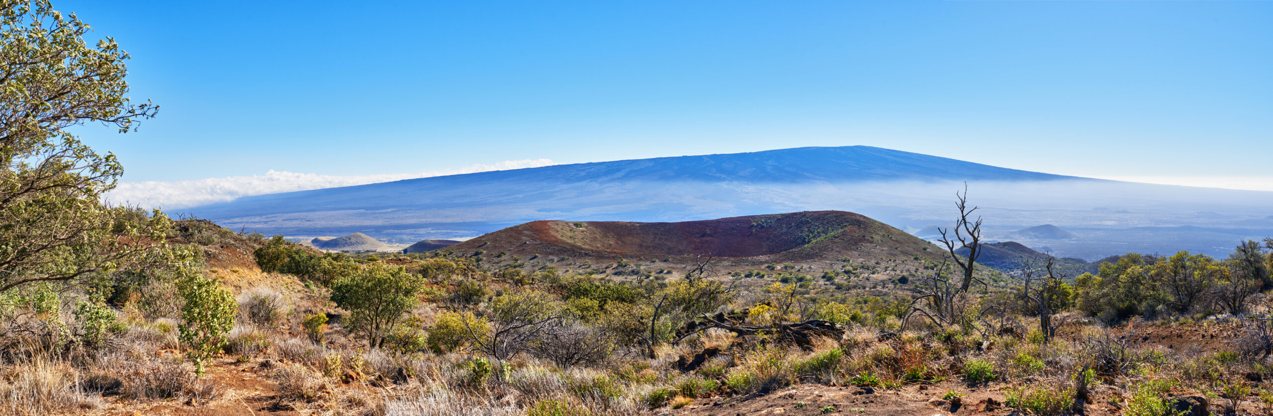
Mauna Loa — literally “Long Mountain” in Hawaiian — is the world’s largest active volcano by volume at approximately 75,000 km³, covering roughly half of Hawaiʻi Island. The 4,169m summit erupted on 27 November 2022 after 38 years of quiescence, with lava fountains reaching 120m at the Mokuʻāweoweo caldera and Northeast Rift Zone flows that destroyed over a mile of the Observatory Road and reached within 4 km of Saddle Road. The mountain remains active and monitored continuously. To Native Hawaiians, Mauna Loa is the home of Pele — the volcano goddess — and stands in cosmic dialogue with neighboring Mauna Kea, the sacred summit of Wākea. Here’s the verified 2026 climbing guide for one of the most demanding non-technical peaks in the United States.
Hawaiʻi Volcanoes National Park. Mauna Loa sits within Hawaiʻi Volcanoes National Park — one of America’s most important volcanic-landscape protected areas. The park was established 1 August 1916 (as Hawaiʻi National Park, with Haleakalā included; split in 1961). The park protects approximately 1,348 km² (333,308 acres) of active volcanic terrain on Hawaiʻi Island including both Mauna Loa and Kīlauea (the famous continuously-erupting volcano). Mauna Loa’s summit area, the Mokuʻāweoweo caldera, and the Mauna Loa Summit Trail are entirely within the park. The Mauna Loa Observatory and Observatory Trail trailhead are technically outside the park boundaries (on Department of Land and Natural Resources land), but the upper Observatory Trail enters park land before the summit. Park entrance fee: $30/vehicle for 7 days (standard NPS rate). Backcountry permits required for overnight cabin use are issued by the park’s Backcountry Permit Office at Kīlauea Visitor Center.
The History of Mauna Loa
Mauna Loa — Hawaiian for “Long Mountain” — rises 4,169 meters (13,681 feet) above sea level on the Big Island of Hawaiʻi. By that measurement alone it is the second-highest peak in Hawaii, just 38 meters (125 ft) lower than its neighbor Mauna Kea. But by virtually any other measurement of size — volume, footprint, base-to-peak height, mass — Mauna Loa is an entirely different scale of mountain. The mountain covers approximately 5,200 km² (2,000 mi²) of the surface of Hawaiʻi Island — roughly half of the island’s total area. By volume, Mauna Loa is approximately 75,000 km³ (18,000 mi³), making it the world’s largest active volcano — and one of the largest single mountains on Earth by any measurement.
Mauna Loa is a classic shield volcano formed by repeated eruptions of relatively fluid basaltic lava that flowed long distances before solidifying. The result is the characteristic broad, gently-sloping mountain form that defines Hawaiian volcanic shields — visually understated compared to steep stratovolcanoes like Mount Fuji or Mount Rainier, but enormously larger in actual mass. The mountain’s mass is so great that the Pacific oceanic crust beneath it has subsided substantially under the volcano’s weight; geologists estimate the true base-to-peak height of Mauna Loa (accounting for crustal subsidence) at approximately 17,170 m (56,300 ft) — substantially taller than Everest’s above-sea-level height, and taller than Mauna Kea’s base-to-peak figure of 10,210 m (Mauna Loa’s greater volume creates greater subsidence beneath the mountain).
Find Hotels, Flights & Trips for the World’s Best Hiking Destinations
The Global Summit Guide Travel Shop on Expedia — curated for outdoor adventurers, mountaineers, and serious hikers. Patagonia to the Alps. Nepal to the Rockies. Curated lodging for every region we cover.
Explore Travel Shop on Expedia →Pele — Goddess of Fire and Volcanoes. In Native Hawaiian (Kānaka Maoli) religious tradition, Mauna Loa is the realm of Pele (sometimes called Pelehonuamea, “Pele of the sacred earth”) — the goddess of fire, volcanoes, lightning, wind, and the creator of the Hawaiian Islands themselves. Pele’s traditional home is generally said to be Halemaʻumaʻu crater within Kīlauea caldera (the currently-active neighbor of Mauna Loa), but her domain extends across the active Hawaiian volcanoes including Mauna Loa, Kīlauea, Hualālai, and the seamount Lōʻihi (now Kamaʻehuakanaloa). Pele is among the most important deities in Hawaiian religion — fierce, beautiful, jealous, and ultimately responsible for the ongoing creation of new Hawaiian land through volcanic activity. The mythological relationship between Pele (fire goddess of Mauna Loa/Kīlauea) and Poliʻahu (snow goddess of Mauna Kea, 70 km away) is preserved in classical Hawaiian oral tradition — the two goddesses are sometimes depicted as rivals, sometimes as cosmic counterparts representing fire and ice. Visitors to Mauna Loa should understand they are entering Pele’s domain: the mountain remains actively sacred in Native Hawaiian practice, and the volcanic activity is religiously meaningful rather than merely geological. The traditional protocol is to take nothing from the mountain — particularly lava rocks, which are considered the body of Pele and which Hawaiian tradition holds will bring misfortune to anyone who removes them. Park rangers and Hawaiian cultural practitioners both reinforce this practice; over 1,000 lava rocks are returned by mail each year by visitors who took them home and subsequently experienced bad luck (the “Pele’s curse” tradition).
~1 Million Years Ago: Mauna Loa Begins
Mauna Loa’s geological history began approximately 1 million years ago (some estimates as recent as 700,000 years ago) when the volcano first emerged above sea level. The mountain is currently in its shield-building stage — the most prolific phase of Hawaiian volcanic evolution, characterized by frequent effusive eruptions producing extensive lava flows. Mauna Loa has been continuously active throughout this period. Geological evidence suggests the mountain has erupted at least 33 times since recorded observation began in 1843, with average intervals of approximately 5-6 years between historical eruptions during the active 19th-20th century period. The shield-building phase will continue for at least several hundred thousand more years before Mauna Loa transitions toward post-shield decline like its neighbor Mauna Kea has done over the past 200,000-500,000 years.
~1100 CE – 1778: Native Hawaiian Era
Polynesian voyagers — the ancestors of modern Native Hawaiians — reached the Hawaiian Islands during the broader Polynesian migration across the Pacific (typically dated 400-1000 CE; continuous occupation from approximately 1100 CE). Mauna Loa was integrated into Hawaiian religious tradition from the earliest period as the realm of Pele and as one of the principal manifestations of volcanic activity. Native Hawaiian oral tradition preserves accounts of major Mauna Loa eruptions long predating written European records — including descriptions of the volcano during what archaeologists believe was a particularly active eruptive period from approximately 1300-1700 CE. The ʻĀinapō Trail (still used today for Summit Cabin access) is among the oldest documented Hawaiian access routes to the Mauna Loa summit, traditionally used by Hawaiian travelers, hunters, and priests. The trail’s name means “trail of darkness” — referring to the practice of starting overnight climbs to reach the summit by dawn.
1779-1840s: First European Observations
The first European observations of Mauna Loa date to the 1779 visit of Captain James Cook to Hawaiʻi, when European observers first noted the enormous mountain dominating the southern Big Island. Cook himself was killed at Kealakekua Bay in February 1779, but his expedition’s records included the first European descriptions of Mauna Loa. The first documented Western ascent of Mauna Loa was made in 1794 by Archibald Menzies, the Scottish surgeon and naturalist with the Vancouver Expedition. Menzies climbed via the south side from Kealakekua Bay and reached the summit on his third attempt — a substantial achievement given the era’s limited equipment and information. The first scientific surveys of the mountain came with the 1841 US Exploring Expedition led by Lieutenant Charles Wilkes, with geologist James Dwight Dana producing the first systematic geological description of Mauna Loa.
1843-1984: 33 Historical Eruptions
Mauna Loa’s modern eruptive history is well-documented from the first recorded historical eruption on 9 January 1843 onward. The mountain produced at least 33 confirmed eruptions between 1843 and 1984 — an average interval of approximately 5 years. Notable historical eruptions:
- 1859 eruption — Northwest Rift Zone flows reaching the Pacific Ocean over a 300-day eruption.
- 1881 eruption — Lava flows reached within 1 mile of present-day downtown Hilo, threatening the town.
- 1926 eruption — Destroyed the village of Hoʻōpūloa on the west coast.
- 1935 eruption — Lava flows threatened Hilo again; the US military controversially bombed flows in an unsuccessful attempt to divert them (the first time aerial bombing was used against a lava flow).
- 1942 eruption — Occurred during WWII; news of the eruption was suppressed for security reasons (Japanese military intelligence might have been able to use the lava glow for navigation).
- 1950 eruption — Southwest Rift Zone flow reached the Pacific in approximately 3 hours, the fastest documented Mauna Loa flow.
- 1975 eruption — Short summit eruption; brief activity at Mokuʻāweoweo caldera.
- 1984 eruption — The last eruption before 2022. Northeast Rift Zone flows came within 4.5 miles of Hilo over 22 days of activity. Established the pattern of summit-then-rift-zone eruption that would repeat in 2022.
After the 1984 eruption, Mauna Loa entered a 38-year quiescence — the longest documented quiet period in the mountain’s modern history. The duration of the quiescence concerned scientists because it suggested substantial magma accumulation; ground deformation measurements showed continuing inflation through the 2010s and 2020s.
1916: Hawaiʻi National Park Established
Hawaiʻi National Park was established on 1 August 1916 — protecting both Mauna Loa and Kīlauea volcanoes (along with Haleakalā on Maui, which was split off as a separate Haleakalā National Park in 1961). The park was the 13th US National Park and the first one in the Pacific. Hawaiʻi Volcanoes National Park (the modern name, following the 1961 split) covers approximately 333,308 acres / 1,348 km² and is among the most heavily-visited US national parks despite the remoteness of the Big Island. The Mauna Loa Summit Trail and Red Hill/Summit cabins were established as park infrastructure in the early 20th century, with substantial improvements made through the Civilian Conservation Corps era (1933-1942) and ongoing maintenance since.
5 October 2022: Summit Closure as 2022 Eruption Builds
By mid-2022, the Hawaiian Volcano Observatory had documented sustained increases in seismicity and ground deformation at Mauna Loa — clear precursor signals of an impending eruption. Earthquake swarms in the summit area intensified through September 2022. On 5 October 2022, the National Park Service closed the Mauna Loa summit area to climbers due to elevated seismic activity — approximately 7 weeks before the eruption actually began. The pre-eruption monitoring period demonstrated the value of continuous USGS surveillance: scientists were able to publicly forecast that an eruption was likely within months, allowing for orderly preparation and visitor safety measures.
The 2022 Eruption: 27 November – 13 December 2022. Mauna Loa erupted on 27 November 2022 at 11:30 PM HST — ending the 38-year quiescence and producing the first eruption of the world’s largest active volcano since 1984. The eruption followed the classic Mauna Loa pattern: summit initiation, then rift zone migration. Phase 1 (Nov 27 night): Fissures opened across the Mokuʻāweoweo summit caldera with lava fountains exceeding 120 meters (390 ft) high. The caldera floor filled rapidly. Phase 2 (Nov 28 morning): Activity migrated to the Northeast Rift Zone with sequential fissure openings (NER_F1 through NER_F4, with NER_F3 becoming dominant). Effusion rate estimated at 50 m³/second from Fissure 3. Phase 3 (Nov 28 afternoon): The Fissure 3 lava flow advanced down the Northeast Rift Zone toward Saddle Road. By 4:30 PM, the flow had crossed and severed the Mauna Loa Observatory access road and power lines. The Observatory site itself was undamaged but cut off from power and road access. Phase 4 (early December): Flows continued advancing toward Saddle Road but slowed and ultimately stalled within approximately 4 km (2.5 miles) of the highway — a remarkably close miss. Eruption end (13 December 2022): Activity ceased after 16 days. Total lava volume approximately 0.2-0.25 km³. Total area covered approximately 40 km². Pele’s hair (volcanic glass fibers) was deposited on Mauna Kea 70 km away and as far north as the town of Honokaʻa (60 km from the source vents). No injuries or fatalities. Property damage approximately $1.5 million (Observatory road and power lines). The eruption was a textbook demonstration of Hawaiian shield-volcano effusive activity — minimal explosive component, fluid basaltic lava, summit-then-rift-zone migration. As of 2026, Mauna Loa has returned to background activity with the USGS Volcano Alert Level at NORMAL and continuous monitoring continuing.
Long Mountain — Why Mauna Loa Is Unlike Any Other Major Peak on Earth
Mauna Loa occupies a position in global mountaineering that’s almost impossible to convey through standard climbing metrics. The mountain is non-technical (no glaciers, no roped climbing required, no significant technical challenges on the standard routes), modestly elevated (4,169m — Mont Blanc is 600m taller, Aconcagua is 2,800m taller), and accessible from a major US tourist island. By those measures, it looks like a casual peak. But Mauna Loa is also the world’s largest active volcano, recently erupted (2022), home of one of the most important deities in Hawaiian religion, and structurally the most committing non-technical mountain in the United States. The reconciliation of these contradictions is the actual Mauna Loa experience.
What makes Mauna Loa structurally distinct from other major peaks:
- The world’s largest active volcano by volume. 75,000 km³. By comparison: Mount Fuji ~1,400 km³ (50x smaller); Mount Etna ~350 km³ (200x smaller); Mount St. Helens ~110 km³ (700x smaller). Among active volcanoes globally, nothing approaches Mauna Loa’s mass. (The extinct Tamu Massif underwater volcano may be larger but is not active and not directly comparable.)
- Currently active — last erupted 2022. The November 27 – December 13, 2022 eruption was the first in 38 years. The mountain remains under continuous USGS monitoring. Future eruptions are expected — most likely beginning at Mokuʻāweoweo caldera, then migrating to one of the rift zones. The previous 38-year quiescence was anomalous; historical eruption intervals averaged 5-6 years during 1843-1984.
- Half of Hawaiʻi Island. The mountain covers approximately 5,200 km² of the surface — roughly half the island. From most points on the Big Island, Mauna Loa is visible as a broad, gently-sloping presence dominating the southern half of the landscape.
- True base-to-peak height of approximately 17,170 m (56,300 ft). When accounting for the substantial crustal subsidence beneath the mountain’s enormous mass, Mauna Loa’s true base-to-peak height is dramatically greater than the above-sea-level 4,169 m. This exceeds Everest’s 8,849 m above sea level. Mauna Kea is 10,210 m base-to-peak; Mauna Loa is taller because of greater mass and greater subsidence.
- The most committing non-technical mountain in the US. The 19.5-mile one-way Mauna Loa Summit Trail is the longest non-technical summit trail of any major US peak. Combined with high altitude (much above 10,000 ft for nearly the entire route), extreme exposure on black lava terrain, sparse facilities, and active-volcano hazards, the standard route is substantially harder than the elevation profile suggests. Climbing Mauna Loa demands genuine multi-day backcountry competence.
- Pele’s mountain. Where Mauna Kea is the sacred domain of Wākea (the sky father) and Poliʻahu (the snow goddess), Mauna Loa is the realm of Pele — the volcano goddess. The two mountains together represent the cosmic duality of fire and ice in Hawaiian religious tradition. Mauna Loa’s volcanic activity is religiously meaningful in Hawaiian practice — the eruption of 2022 was actively interpreted as Pele’s continuing presence. Visitors should approach the mountain with this context in mind.
- The “Pele’s curse” tradition. Native Hawaiian tradition holds that lava rocks taken from Pele’s mountains will bring misfortune. Hawaiʻi Volcanoes National Park receives over 1,000 returned lava rocks per year from visitors who took them home and subsequently believed they experienced bad luck. The tradition is taken seriously by Hawaiian cultural practitioners and reinforced by park rangers. Do not take lava rocks from Mauna Loa.
Where Mauna Loa fits in mountaineering progression: Mauna Loa is misleadingly classified as a “beginner non-technical peak” but functions in practice as an advanced endurance objective. The mountain teaches multi-day high-altitude backcountry skills — pacing, navigation across cairned lava terrain, cabin systems, weather discipline, dehydration management — that translate directly to harder international objectives. As standalone goal, summiting Mauna Loa is one of the most substantive mountain achievements available in Hawaii and a meaningful state-high-point-adjacent objective. As preparation for Mount Whitney or Mount Elbert, Mauna Loa’s altitude exposure transfers well. As preparation for African or Mexican volcanoes (Kilimanjaro, Pico de Orizaba), Mauna Loa’s combination of altitude, distance, and lava terrain is genuinely useful training. As preparation for expedition objectives (Denali, Aconcagua), the multi-day backcountry skill set is directly applicable. As “a long Hawaii hike” — no, this is genuinely not that. Approach Mauna Loa with respect for what 19.5 miles and 4,169m and active volcanism actually mean in practice.
Mauna Loa Historical Timeline
Mauna Loa’s volcanic construction begins on the Pacific seafloor as part of the Hawaiian-Emperor hotspot chain. The mountain first emerges above sea level approximately 1 million years ago (some estimates as recent as 700,000 years ago) and enters its shield-building stage.
Polynesian voyagers reach Hawaiʻi during the broader Polynesian Pacific migration. Mauna Loa is integrated into Hawaiian religious tradition as the realm of Pele — the volcano goddess. The ʻĀinapō Trail (“trail of darkness”) is among the oldest documented Hawaiian access routes to the summit.
Hawaiian oral tradition preserves accounts of major Mauna Loa eruptions during what archaeologists believe was a particularly active period. The mountain is integrated into Hawaiian religious life as one of the principal manifestations of Pele’s presence.
Captain James Cook’s expedition produces the first European descriptions of Mauna Loa. Cook himself is killed at Kealakekua Bay on 14 February 1779, but expedition records include observations of the enormous mountain dominating the southern Big Island.
Scottish surgeon and naturalist Archibald Menzies, with the Vancouver Expedition, makes the first documented Western ascent of Mauna Loa from the south side via Kealakekua Bay. Reaches the summit on his third attempt — a substantial achievement given the era’s limited equipment.
The US Exploring Expedition led by Lt. Charles Wilkes conducts the first formal scientific survey of Mauna Loa. Geologist James Dwight Dana (later the founder of modern American geology) produces the first systematic geological description of the mountain.
The first documented historical eruption of Mauna Loa in the modern record. The beginning of the well-documented eruptive era — at least 33 confirmed eruptions through 1984, averaging approximately 5-6 year intervals during the active 19th-20th century period.
Northeast Rift Zone lava flows reach within approximately 1 mile of present-day downtown Hilo. The flows ultimately stall before destroying the town but establish Mauna Loa’s pattern of threatening lower-elevation settlements via rift zone activity.
Hawaiʻi National Park established — protecting Mauna Loa, Kīlauea, and (originally) Haleakalā. The 13th US National Park and the first one in the Pacific. Haleakalā becomes a separate national park in 1961; the original park is renamed Hawaiʻi Volcanoes National Park.
Mauna Loa lava flows destroy the village of Hoʻōpūloa on the west coast — among the most destructive Mauna Loa eruptions of the 20th century. Demonstrates the mountain’s capacity for serious property destruction during major effusive events.
During the 1935 eruption, lava flows threaten Hilo again. The US military controversially bombs the flows in an unsuccessful attempt to divert them — the first time aerial bombing is used against a lava flow. The bombing has minimal effect; flows ultimately stop on their own.
Mauna Loa erupts during WWII. News of the eruption is suppressed for several months for security reasons — Japanese military intelligence might have been able to use the lava glow for navigation purposes. The Pacific theater context of an active volcano on a major US territory is genuinely unusual.
The 1950 eruption produces a Southwest Rift Zone flow that reaches the Pacific Ocean in approximately 3 hours — the fastest documented Mauna Loa lava flow. Demonstrates the volcano’s capacity for rapid-onset major events.
22-day Northeast Rift Zone eruption. Lava flows come within 4.5 miles of Hilo. Establishes the summit-then-rift-zone pattern that would repeat in 2022. After 1984, Mauna Loa enters a 38-year quiescence — the longest documented quiet period in the mountain’s modern history.
Ground deformation measurements show continuing inflation through the 2010s. Earthquake swarms intensify through 2020-2022. By September 2022, the Hawaiian Volcano Observatory publicly forecasts an eruption is likely within months. The pre-eruption monitoring period demonstrates the value of continuous USGS surveillance.
National Park Service closes the Mauna Loa summit area to climbers due to elevated seismic activity — approximately 7 weeks before the eruption actually begins. The pre-emptive closure prevents potential climbers from being caught in eruption onset.
Mauna Loa erupts — ending the 38-year quiescence. Fissures open across the Mokuʻāweoweo summit caldera with lava fountains exceeding 120 meters (390 ft) high. The caldera floor fills rapidly. USGS issues Volcano Alert Level WARNING and Aviation Color Code RED.
Sequential fissure openings on the Northeast Rift Zone (NER_F1 through NER_F4, with NER_F3 dominant). Lava flows advance down the rift zone toward Saddle Road. By 4:30 PM, the Fissure 3 flow crosses and severs the Mauna Loa Observatory access road and power lines.
Mauna Loa eruption ends after 16 days. Total lava volume approximately 0.2-0.25 km³. Total area covered approximately 40 km². Lava came within ~4 km of Saddle Road but stalled. No injuries or fatalities. Property damage approximately $1.5 million (Observatory road and power lines).
Post-eruption recovery. Pathfinder road construction through the 2022 lava flow on the Observatory access road. Trail damage assessments on the standard Mauna Loa Trail and Summit Cabin access. Continued ʻĀinapō Trail access to the Summit Cabin via Kapāpala Ranch. Park reopening of various access points on staged timeline.
Mauna Loa Observatory access road pathfinder construction expected to conclude. Full road reopening to Observatory traffic anticipated. Mauna Loa remains at USGS Volcano Alert Level NORMAL with continuous Hawaiian Volcano Observatory monitoring. Mountain capable of rapid reactivation; future eruptions expected within the next decade.
The Mauna Loa Trails
Mauna Loa has three principal hiking routes, all non-technical but each substantially demanding. The Observatory Trail is the standard day-hike summit route. The Mauna Loa Summit Trail from the Park Lookout is the classic multi-day backpack. The ʻĀinapō Trail is the historic Hawaiian access route with significant permit complexity. None are “easy” — all three demand multi-thousand-foot vertical gain at altitude on exposed lava terrain.
| Trail | Style | Distance / Gain | Days | Status |
|---|---|---|---|---|
| Observatory Trail (Mokuʻāweoweo) | Day hike, summit-only | 12.8 mi RT / 2,531 ft gain | 1 day (8-12 hrs) | ● Open · Standard day hike · ~60% of summits |
| Mauna Loa Summit Trail (Park) | Multi-day backpack with cabins | 38+ mi RT / 7,000+ ft gain | 3-4 days | ● Open · Cabin access verify with park |
| ʻĀinapō Trail (Historic Hawaiian Route) | Multi-day, multi-permit | 25+ mi RT / 6,000+ ft gain | 3 days | ● Open · 2 permits required + 4WD |
| Bird Park / Park Lookout Day | Lower-mountain day hike | Up to 4 mi RT | Half day | ● Open · Year-round, accessible |
Observatory Trail (Mokuʻāweoweo Trail) — The Standard Summit Day Hike
Style: Class 1 hiking on cairned lava terrain — no technical climbing · Used by ~60% of summit climbers.
Trailhead: Mauna Loa Observatory at 11,150 ft / 3,400m elevation. Accessed via the Mauna Loa Observatory Road (often called “Mauna Loa Access Road”) which departs from Daniel K. Inouye Highway (Saddle Road) west of mile marker 22. The road is paved most of the way but has substantial elevation gain — 30-45 minute drive from Saddle Road. Important 2026 status: The Observatory Road sustained substantial damage in the 2022 eruption (Fissure 3 flow crossed the road); pathfinder reconstruction was scheduled to complete in early April 2026. Verify current road status with the park before driving.
The Climb: 12.8 miles / 20.5 km round-trip · 2,531 ft / 771 m elevation gain · 4,169m summit:
- Observatory (11,150 ft) → North Pit (12,800 ft): Ascent on cairned ʻaʻā and pāhoehoe lava terrain. Above-treeline throughout (Mauna Loa has no trees at this elevation). The volcanic landscape is genuinely otherworldly — black and red volcanic rock extending to the horizon. ~3-4 hours.
- North Pit → Mokuʻāweoweo Caldera Rim: Approach to the summit caldera rim. The 3 km × 5 km caldera opens up to the south — one of the most dramatic geological viewpoints in the United States. ~30-45 minutes.
- Caldera Rim → True Summit (Puʻu Wēkiu, 13,681 ft): The true summit sits on the western rim of the Mokuʻāweoweo caldera. Optional but recommended for “true summit” climbers. ~30-45 minutes from caldera rim.
- Total summit-day: 8-12 hours round-trip for fit hikers; 6-8 hours for very strong hikers. Long day at altitude on exposed terrain.
Why climbers choose it: Shortest route to the summit. Most efficient single-day option. No overnight permit required (day use only). Avoids the multi-day backcountry permit complexity. Less weather exposure than multi-day routes.
The trade-off: Higher starting altitude means less acclimatization time on the mountain itself — climbers must arrive already acclimatized (1-2 nights at 8,000-10,000 ft elevation strongly recommended). The Observatory Road access remains 2022-eruption-affected through 2026 — verify current status.
Permit: No permit required for day use from the Observatory Trail. Free parking at the Observatory trailhead. Park entrance fee applies if accessing through the National Park ($30/vehicle, 7 days). No overnight backpacking permitted on this trail — day use only.
Mauna Loa Summit Trail — The Classic Multi-Day Backpack
Style: Multi-day backcountry backpack with mountain cabins · The historical “standard” Mauna Loa climb.
Trailhead: Mauna Loa Lookout at 6,662 ft / 2,030m elevation. Accessed via the Mauna Loa Road within Hawaiʻi Volcanoes National Park — departs from Highway 11 west of the Kīlauea Visitor Center. ~50-minute drive to the Lookout from Kīlauea. The road is paved and accessible to all vehicles. Free parking at the Lookout.
The Climb: 19.5 miles / 31 km one-way · 38+ miles / 62 km round-trip · 7,000+ ft / 2,135 m elevation gain · Standard 3-4 day backpack:
- Day 1: Mauna Loa Lookout (6,662 ft) → Red Hill Cabin (10,035 ft): 7.5 miles / 12 km one way · 3,373 ft gain · 6-8 hours. The first day of climbing through subalpine terrain into the alpine lava landscape. Red Hill Cabin (Pu’u ‘Ula’ula) is the standard first-night stop — primitive shelter with bunks for ~8 climbers, basic facilities, no water on-site (carry all water from below or melt snow when available).
- Day 2: Red Hill Cabin (10,035 ft) → Mauna Loa Summit Cabin (13,250 ft): 11.5 miles / 18.5 km one way · 3,215 ft gain · 8-12 hours. The longest and highest day. The trail crosses extensive lava terrain with cairn-marked route through alternating ʻaʻā and pāhoehoe lava fields. Summit Cabin sits just below the caldera rim. 2026 status: Summit Cabin access from the standard Mauna Loa Trail has been affected by 2022 eruption damage; verify current cabin operational status with the park’s Backcountry Office before trip. Cabin sleeps ~12, basic facilities.
- Day 3: Summit Cabin → Puʻu Wēkiu Summit (13,681 ft) → Return: Summit-day push and return to lower cabins. ~6-8 hours total for the summit-day push.
- Day 4: Red Hill Cabin → Lookout: Return to trailhead. 7.5 miles / 12 km · descent. 4-6 hours.
Why backpackers choose it: The full Mauna Loa experience — multi-day immersion in one of the world’s most extensive volcanic landscapes. Cabin system allows non-camping backcountry travel. Lower starting altitude (6,662 ft) provides built-in acclimatization. Genuinely substantial mountaineering achievement.
The trade-off: Major logistical complexity (backcountry permits, cabin reservations, food/water/fuel for multiple days). Substantial endurance demands. Substantial weather exposure across 3-4 days. The 2022 eruption affected portions of the upper trail and Summit Cabin access — current status varies.
Permit: Free backcountry permit required from Hawaiʻi Volcanoes National Park. Permits issued in person at the Backcountry Permit Office, Kīlauea Visitor Center, the day before the trip. Cabin reservations required (also free). Park entrance fee $30/vehicle, 7 days.
ʻĀinapō Trail — The Historic Hawaiian Access Route
Style: Historic Native Hawaiian access route — significantly more administrative complexity than other trails.
Trailhead: ʻĀinapō Trailhead at approximately 5,650 ft / 1,720m elevation. Accessed via ʻĀinapō Road through Kapāpala Ranch (a private working ranch). ʻĀinapō Road is a rough unpaved 4WD-only road; high-clearance vehicle required. The trail is accessed from Highway 11 east of Pāhala via the ranch.
The Climb: 25+ miles / 40 km round-trip · 6,000+ ft / 1,830 m elevation gain · Standard 3-day backpack. The ʻĀinapō Trail connects with the upper Mauna Loa Trail near the Summit Cabin. Currently (post-2022 eruption) the ʻĀinapō Trail is the primary documented access route to the Summit Cabin while standard Mauna Loa Trail damage is repaired.
Historic significance: The ʻĀinapō Trail is among the oldest documented Hawaiian access routes to the Mauna Loa summit. The trail’s name means “trail of darkness” — referring to the traditional practice of starting overnight climbs to reach the summit by dawn. Pre-contact Hawaiian climbers, hunters, and priests used this route for centuries before European arrival. The trail was formally reestablished in the modern era for recreational use, but it remains the most historically significant Hawaiian access to the mountain.
Permit complexity: Climbers must obtain TWO separate permits:
- Kapāpala Ranch gate access permit — issued by the Hawaiʻi Department of Land and Natural Resources (DLNR) Forestry & Wildlife Division. Required to drive through the working cattle ranch to reach the trailhead. Includes ranch gate combination/key access.
- Hawaiʻi Volcanoes National Park backcountry permit — required for Summit Cabin overnight use. Same permit system as the standard Mauna Loa Trail.
Why hikers choose it: Currently the primary documented access to the Summit Cabin since 2022 eruption damage to standard Mauna Loa Trail portions. Historic Hawaiian cultural significance. Substantially less-traveled than the other routes. Strong sense of historical continuity with traditional Hawaiian climbing practice.
The trade-off: Substantial administrative complexity (two separate permit applications, ranch gate logistics, 4WD vehicle requirement). Less well-marked than the standard Mauna Loa Trail. Significantly more committing — fewer climbers means less rescue support if problems arise.
Lower Mountain Options — Day Hikes Without Summit
For visitors who want to experience Mauna Loa terrain without the full summit commitment, several substantive lower-mountain day-hike options exist within Hawaiʻi Volcanoes National Park:
- Mauna Loa Lookout Day Visit — Drive to the Mauna Loa Lookout (6,662 ft / 2,030m) on Mauna Loa Road, enjoy panoramic views of the lower mountain and the Kīlauea caldera complex, take short walks in the trailhead area. ~30 minutes drive each way from Kīlauea Visitor Center.
- Mauna Loa Trail to Pu’u ‘Ula’ula (Red Hill) — Day Out-and-Back — Hike the first 7.5 miles of the Mauna Loa Trail to Red Hill (10,035 ft) and return as a day hike. Substantial 6,000+ ft elevation experience over a 15-mile round-trip. Very demanding day hike — recommended only for fit hikers comfortable with all-day backcountry travel.
- Kīpukapuaulu (Bird Park) — Short trail through a kīpuka (a forested island surrounded by lava flows) accessible from Mauna Loa Road. ~1.2 mile loop, easy. Excellent native Hawaiian forest experience.
- Kahuku Unit Trails — Western Mauna Loa lower-slope trails in the Kahuku Unit of Hawaiʻi Volcanoes National Park. Variable distances; explore historic ranching landscapes on Mauna Loa’s western flank.
Why these matter: Many visitors come to Hawaiʻi without time, fitness, or acclimatization for the full Mauna Loa summit climb. The lower-mountain options provide meaningful Mauna Loa experiences accessible to ordinary travelers without altitude exposure or multi-day commitment.
The Mauna Loa Summit Trail Progression (Classic Multi-Day Route)
The classic multi-day Mauna Loa Summit Trail progresses through these named locations. Note the substantial elevation and distance — this is one of the most committing non-technical mountain experiences available in the United States:
The cabin reservation challenge. Both the Red Hill Cabin and the Mauna Loa Summit Cabin require advance reservation through the National Park Service backcountry permit system. Cabins are free but capacity is limited (Red Hill ~8 climbers; Summit Cabin ~12). During peak season (April-October), cabin availability can be tight — particularly Friday and Saturday nights. Permits are issued in person only at the Backcountry Permit Office at Kīlauea Visitor Center the day before the trip — there is no online reservation system. 2026 status: Summit Cabin access has been affected by 2022 eruption damage to portions of the standard Mauna Loa Trail; the ʻĀinapō Trail is currently the primary documented access. Verify cabin operational status with the park’s Backcountry Office within a week of your trip — situation continues to evolve.
Costs & 2026 Logistics
Mauna Loa is among the most affordable major peak-experience options in the United States — all permits are free, backcountry cabins are free, and even the park entrance fee is modest. The bulk of trip costs are travel to and lodging on Hawaiʻi Island, not Mauna Loa-specific expenses.
| Item | Cost | Notes |
|---|---|---|
| Hawaiʻi Volcanoes National Park entrance | $30/vehicle (7 days) | Standard NPS rate; covers all park access including Mauna Loa Road; America the Beautiful pass accepted |
| Backcountry permit (multi-day) | $0 (free) | Issued in person at Backcountry Permit Office, Kīlauea Visitor Center, day before trip; required for cabin overnight |
| Red Hill Cabin overnight | $0 (free) | Reservation required via backcountry permit system; sleeps ~8; basic facilities |
| Summit Cabin overnight | $0 (free) | Reservation required; sleeps ~12; basic facilities; 2026 access status varies |
| Observatory Trail day-use | $0 (free) | No permit required; free parking at Observatory trailhead; verify Observatory Road status 2026 |
| ʻĀinapō Trail permits | $0 (both free) | Kapāpala Ranch gate permit (DLNR) + park backcountry permit; substantial administrative effort but no fee |
| 4WD vehicle rental (Big Island) | $80-$150/day | Required for ʻĀinapō Trail access; recommended for Observatory Road; rental car prohibitions less strict than Mauna Kea |
| Hilo lodging (per night) | $140-$280 | Closer staging town; standard hotels; rainforest east side |
| Volcano Village lodging | $130-$300 | Nearest accommodation to Hawaiʻi Volcanoes NP; cabins, B&Bs, vacation rentals; intermediate elevation (4,000 ft) |
| Kona/Waikoloa lodging | $200-$650+ | West-side resort areas; longer drive to Mauna Loa; broader hotel options |
| Big Island airfare (Hilo or Kona) | $300-$800 RT mainland | From US west coast typically $300-$500; from east coast $600-$800 |
| Inter-island flight (HNL → ITO/KOA) | $150-$300 RT | Hawaiian Airlines, Southwest, Mokulele; ~45 min flight time |
| Backpacking gear rental (if needed) | $100-$300 for full kit | Limited options on Big Island; consider Honolulu rentals or shipping gear |
| Guided climbs | $1,500-$3,500+ per person | Multi-day guided programs from limited Big Island operators; substantially more expensive than self-guided |
| Independent Observatory Trail day climb | $100-$250 per person | 4WD rental + park entrance + lodging + food + gas; assumes Big Island base |
| Independent 3-day Summit Trail backpack | $300-$700 per person | Park entrance + lodging + food + gas; 3 days on mountain (free cabins) + 1 day buffer |
| Full Big Island Mauna Loa trip (5-7 days) | $1,200-$3,000 per person | Flights + lodging + food + park access + gear + buffer days — cheapest “major US peak” experience by far |
Mauna Loa is the cheapest major US summit experience accessible to ordinary travelers. No other US peak of comparable elevation and substance offers free permits, free cabins, no entry quota, and modest park fees. Mount Whitney requires a competitive permit lottery and substantial Lone Pine lodging ($400-$1,500 total). Mount Hood requires technical glaciated guiding ($1,200-$2,000). Mount Rainier requires multi-day guided expeditions ($1,650-$2,200). Mauna Loa can be summited via the Observatory Trail in a single $100-$250 day or backpacked over 3-4 days for under $700 — substantially the most affordable “major peak” experience in the United States. The trade-off: the logistical complexity is real (Big Island travel, 2022 eruption recovery status, cabin reservation in-person-only system), and the mountain’s accessibility belies its actual demands. The cheap permit doesn’t make the 19.5-mile one-way trail any shorter.
The 2022 eruption recovery — verify current status before trip. The November-December 2022 eruption affected Mauna Loa infrastructure in several specific ways: (1) Observatory Road damage — over a mile of road destroyed by the Fissure 3 lava flow; pathfinder reconstruction scheduled for completion April 2026; verify current access status before relying on Observatory Trail access. (2) Summit Cabin access affected — portions of the standard Mauna Loa Trail were affected by upper-mountain eruption activity; the Summit Cabin may not be accessible from the standard trail; ʻĀinapō Trail is currently the primary documented access. (3) Trail damage assessments ongoing — the National Park Service has continued trail assessments and may have route restrictions; check with the Backcountry Office at Kīlauea Visitor Center. (4) Volcanic activity status — Mauna Loa is at USGS Alert Level NORMAL as of 2026 but remains capable of rapid reactivation; check the USGS Hawaiian Volcano Observatory daily updates before climbing. Always verify current trail and volcano status within a week of your trip departure.
Best Time to Climb & Mauna Loa Weather
Mauna Loa is accessible year-round but conditions vary substantially with elevation and season. The prime climbing window runs April through October, with May and September offering the most stable weather. Winter conditions (December-March) can bring snow, ice, and trail closures.
| Period | Window | Conditions | Watch For |
|---|---|---|---|
| Winter Storm Season | December – March | Snow on upper mountain; ice on trails; cabins exposed to severe weather | Snow possible in any season but most likely now; trail markings may be obscured; substantially more challenging multi-day trips |
| Spring Transition | April – May | Improving weather; lingering snow possible above 12,000 ft; warming days | Variable conditions; some lingering snow at altitude; reliable trail markings emerging |
| Prime Climbing Season | June – August | Most stable weather pattern; reliable trail conditions; warmest days; longest daylight | Strong sun exposure on black lava; extreme UV at altitude; afternoon weather patterns possible |
| Best Stable Weather | September – October | Often the most reliable weather of the year; clearer skies; cooler than summer; fewer rain events | Peak season for serious multi-day climbs; cabins may book up faster |
| Off-Season | November – March | Variable; substantial weather variability; potential snow and storms | Pre-trip park status check essential; 2022 eruption season historical context — Mauna Loa erupted in late November |
Summit weather realities — substantially worse than Hawaiʻi tourist expectations. Mauna Loa’s summit weather is genuinely severe regardless of tropical sea-level conditions: average summer summit temperatures 30-50°F (-1°C to 10°C), regularly dropping below freezing at night even in July-August. Winter summit can reach 10°F (-12°C) or below. Wind speeds regularly 20-40 mph; gusts to 70+ mph in storms. UV exposure is among the most extreme in the United States due to high altitude, tropical sun angle, and extensive black lava terrain that reflects and radiates heat. Snow is possible in any season — multiple snow events have occurred even in mid-summer. The mountain has caused multiple climber deaths over the decades from exposure, dehydration, altitude-related events, and lava terrain falls. The “Hawaii is tropical” tourist intuition is dangerously wrong above 10,000 ft.
Essential Gear Checklist
Mauna Loa’s gear requirements are substantial for a non-technical peak — driven by the combination of high altitude, multi-day backcountry character (for the Summit Trail), extreme sun exposure on black lava, severe summit cold despite Hawaiian latitude, and limited rescue resources. Standard Hawaiʻi tourist gear is completely inadequate.
Observatory Trail Day Hike
- Sturdy hiking boots with ankle support
- Synthetic or merino base layers
- Lightweight insulating mid-layer (fleece or down)
- Windshell / rain jacket
- Long pants (sun + wind protection)
- Warm hat or beanie
- Lightweight gloves
- Wide-brim sun hat for lower trail
- Sunglasses (Category 3-4 — UV is extreme)
- Headlamp + spare batteries (for early starts and weather buffer)
- Trekking poles (highly recommended)
- 30-40L daypack
Mauna Loa Summit Trail (3-Day Backpack)
- 50-65L expedition pack
- Sleeping bag rated to 20°F / -7°C minimum
- Sleeping pad (cabin floors are basic)
- Mountaineering boots with ankle support
- Layered upper body: 2x base + insulating + insulated jacket
- Hardshell jacket + pants
- Warm hat, insulated gloves + glove liners
- Headlamp + spare batteries + backup light
- Trekking poles (essential for descent)
- Map, compass, GPS device (backup for cairned route)
- 4+ liters water capacity (no water on mountain)
- 3-4 day food supply (~3,500 cal/day at altitude)
- Camp stove + fuel (water boiling/cooking)
- First aid kit (comprehensive)
- Emergency bivvy or shelter
- Personal medication including any altitude prescriptions
Water and Food Strategy
- 4+ liters per person per day on mountain (no resupply available)
- Electrolyte tablets / sports drinks (altitude depletes electrolytes)
- 3,500-4,500 calories/day at altitude (cold + effort + altitude metabolism)
- High-calorie dehydrated meals for multi-day trips
- Caffeinated drinks/gels for long summit-days
- Salty snacks (potato chips, salted nuts) — surprisingly effective at altitude
- Comfort food for cabin nights — psychological value
- Trash bags for all waste (pack out everything, including human waste in some areas)
Volcanic Terrain Specific
- Sturdy boots — lava rock is sharp and abrasive
- Gaiters — protect against lava cinders entering boots
- Multiple sock layers for blister prevention on irregular terrain
- Tape (medical or duct) for blister prevention/treatment
- Sunscreen SPF 50+ (apply liberally and repeatedly)
- Lip balm with SPF
- Buff or neck gaiter (sun, wind, dust)
- Goggles or wraparound sunglasses (volcanic dust)
- Spare boot laces (lava rock is hard on laces)
- Repair tape for clothing (lava rock cuts gear)
Difficulty & What Mauna Loa Actually Demands
Mauna Loa is one of the most consistently underestimated peaks in the United States. The “non-technical hike” classification creates a fundamentally misleading picture. The actual challenges are altitude, distance, exposure, and the genuine multi-day backcountry character of the standard summit route. Five specific characteristics define what the mountain actually demands:
1. The altitude is real and substantial. 4,169m is sufficient to produce moderate-to-severe AMS in unacclimatized climbers. The Observatory Trail starts at 11,150 ft / 3,400m — meaning hikers experience high-altitude conditions throughout the route. The Mauna Loa Summit Trail starts at 6,662 ft / 2,030m but ascends to 13,250 ft (Summit Cabin) and 13,681 ft (summit) over the multi-day route. Approximately 30-50% of climbers experience meaningful AMS symptoms. Spending 1-2 nights at intermediate elevation (8,000-10,000 ft, such as Volcano Village or Hilo’s higher neighborhoods) before the climb substantially improves outcomes. The most common cause of failed Mauna Loa attempts is altitude-related rather than fitness-related.
2. The distance is the actual crux of the standard Summit Trail. 19.5 miles one way is genuinely long — substantially longer than most American climbers will have experienced. 38+ miles round-trip with 7,000+ feet of vertical gain represents a multi-thousand-foot endurance demand at altitude on exposed terrain. Many climbers who could easily handle the elevation profile (similar to a Mount Whitney day hike) fail because of the cumulative distance. The cabin system mitigates this but does not eliminate it — you still must cover the miles each day with full pack weight. Training: weekly long backpacking trips of 15-20 miles for several months before the attempt. Without this base, the trail is likely to feel substantially harder than the elevation profile suggests.
3. The exposure on black lava terrain is harsh. Above approximately 8,000 ft, Mauna Loa offers virtually no shelter — no trees, no natural windbreaks, no caves, no shaded areas. The mountain’s signature black lava terrain absorbs and radiates heat during the day and provides minimal protection from wind, sun, and weather throughout. Combined with the extreme UV at altitude on the high-reflectivity black surfaces, the sun exposure is among the most extreme in any major US peak experience. Sunscreen, sun hats, and sunglasses are not optional. Dehydration develops faster than climbers typically expect. The exposure is more severe than the climate numbers alone suggest.
4. The active volcano hazard is real. Mauna Loa is not a “former active volcano” — it is currently active, recently erupted (2022), and capable of rapid reactivation. The 2022 eruption was preceded by approximately 7 weeks of elevated seismic activity that prompted the National Park Service to close the summit on 5 October 2022 — well before the actual eruption began on 27 November. The pre-emptive closure prevented climbers from being caught in eruption onset, but the underlying risk remains: future eruptions are expected within the next decade, and the warning window between elevated seismicity and actual eruption may be days to weeks rather than months. Check the USGS Hawaiian Volcano Observatory daily updates (volcanoes.usgs.gov/observatories/hvo) before any Mauna Loa climb. Trust ranger recommendations about closures — they are based on real-time scientific monitoring.
5. The remoteness is greater than the maps suggest. Once committed to the upper Mauna Loa, climbers are in genuinely remote terrain. The Mauna Loa Summit Trail from the National Park Lookout climbs through 19.5 miles of essentially uninhabited backcountry with no road access, no cellular service for most of the route, sparse cabin facilities, no water resupply, and rescue response times measured in hours-to-days rather than minutes-to-hours. The 2022 eruption demonstrated that even basic infrastructure (Observatory access road, power lines) is vulnerable to volcanic activity. Self-sufficiency is genuinely required. Carry emergency communication (Garmin inReach or similar satellite messenger strongly recommended). Trust your turn-around decisions — there is no shortcut down from the upper mountain.
What Mauna Loa rewards: Climbers with multi-day backpacking experience already in their résumé (substantial vertical gain backpacks of 15-20+ miles), 1-2 nights of intermediate-elevation acclimatization before the climb, comprehensive backcountry gear including emergency communication, willingness to follow park backcountry protocols and ranger guidance, respect for active-volcano hazards and willingness to abort if seismic activity escalates, cultural awareness of the mountain’s significance as Pele’s domain, and “expedition planning” framing rather than “casual hike” framing. As standalone goal, summiting Mauna Loa is one of the most substantive American mountaineering achievements available without technical skills — a 19.5-mile, 4,169m, active-volcano summit. As preparation for Kilimanjaro, the combination of altitude, distance, lava terrain, and multi-day cabin system is genuinely useful training. As preparation for Mount Whitney, the altitude exposure transfers directly. As preparation for Pico de Orizaba, the volcanic high-altitude exposure is parallel. As “a long Hawaii hike” — no. Approach Mauna Loa with respect for what 19.5 miles, 4,169m elevation, active volcanism, and the cosmic presence of Pele actually mean in practice.
Featured Mauna Loa Operators & Resources
Mauna Loa is rarely climbed with commercial guides — the mountain’s accessibility, free permits, and self-guided cabin system mean most successful climbers go independently. A small number of operators offer guided programs, primarily for international visitors or those who want logistics handled. The most important “resource” for Mauna Loa climbers is actually the National Park Service Backcountry Office and the USGS Hawaiian Volcano Observatory, not commercial operators.
Hawaiʻi Volcanoes National Park (Backcountry Office)
The essential first stop for any multi-day Mauna Loa climb. The Backcountry Permit Office at the Kīlauea Visitor Center issues all backcountry permits and cabin reservations for the Mauna Loa Summit Trail. Permits are issued in person only, the day before the trip. Rangers provide current trail conditions, cabin status, and route guidance. The office also coordinates with the USGS Hawaiian Volcano Observatory on current volcanic activity status. nps.gov/havo — call ahead for current permit status: (808) 985-6000.
USGS Hawaiian Volcano Observatory (HVO)
The scientific authority monitoring Mauna Loa and the source of current volcanic activity assessments. HVO publishes daily updates, alert level changes, and detailed seismic/deformation data for Mauna Loa. Essential pre-trip check within a week of departure. The 2022 eruption forecast (and the 7-week pre-eruption summit closure) was based on HVO monitoring. usgs.gov/observatories/hvo
Hawaii Forest & Trail
The major Big Island guide operator offers Mauna Loa programs alongside other Hawaiian volcanic experiences. Guided Observatory Trail day hikes available; multi-day Summit Trail programs less common but available by special arrangement. hawaiiforest.com/mauna-loa
Hilo-Based Local Guide Companies
Small Hilo-based operators occasionally offer guided Mauna Loa programs. Quality and availability vary substantially. Check current local options through Big Island visitor centers or rangers — there is no consistent commercial guide service equivalent to those on Mount Rainier or Mount Whitney.
Mountain Guide Independent Hire
Some climbers hire AMGA-certified guides individually for Mauna Loa expeditions. Costs $1,500-$3,500+ per person depending on group size and program length. The mountain’s accessibility means this is rarely necessary — most fit climbers can complete the standard routes independently with good preparation.
Kapāpala Ranch (ʻĀinapō Trail Gate Access)
Not a guide service, but the essential coordination point for ʻĀinapō Trail access. The DLNR Forestry & Wildlife Division issues the Kapāpala Ranch gate permit; climbers coordinate directly with the ranch for gate combination/access. Significantly more administrative complexity than other access routes. Contact through Hawaiʻi DLNR Forestry & Wildlife Division Hilo office for current permit procedures.
Frequently Asked Questions
Mauna Loa rises to 4,169 meters (13,681 feet) above sea level on the Big Island of Hawaiʻi — making it the second-highest peak in Hawaii after its 38-meter-taller neighbor Mauna Kea. However, Mauna Loa is by volume the world’s largest active volcano — approximately 75,000 km³ — and one of the largest mountains on Earth measured from base to peak (approximately 17,170m / 56,300 ft from the seafloor when accounting for ocean-floor subsidence under the mountain’s enormous weight). The mountain covers approximately half of the surface area of Hawaiʻi Island. Coordinates: 19.4794°N, 155.6028°W. The summit is the Mokuʻāweoweo caldera — a 3 km × 5 km collapse caldera.
Mauna Loa’s most recent eruption began on 27 November 2022 at 11:30 PM HST and ended on 13 December 2022 — a 16-day eruption that ended a 38-year quiescence (the previous eruption was in 1984). The 2022 eruption began with fissures in the Mokuʻāweoweo summit caldera with lava fountains reaching 120+ meters high. Activity migrated to the Northeast Rift Zone where multiple fissures produced lava flows advancing approximately 40 km² and reaching within ~4 km of the cross-island Saddle Road. Lava destroyed over a mile of the Mauna Loa Observatory access road and power lines. Total lava volume approximately 0.2-0.25 km³. No injuries or fatalities; approximately $1.5 million in property damage. As of 2026, Mauna Loa has returned to background activity with the USGS Volcano Alert Level at NORMAL and continuous monitoring continuing.
By volume of erupted material, Mauna Loa is the world’s largest active volcano — approximately 75,000 km³. The mountain covers approximately half of Hawaiʻi Island’s surface area. By comparison, Mount Fuji is approximately 1,400 km³; Mount Etna approximately 350 km³; Kilauea approximately 25,000 km³. The title is contested: in 2013, scientists identified Tamu Massif (an underwater volcano in the northwest Pacific) as potentially larger by volume, though Tamu Massif is generally considered extinct and not directly comparable. Among active volcanoes monitored by national agencies, Mauna Loa retains the distinction. The mountain is approximately 17,170m (56,300 ft) tall from base to peak when accounting for ocean-floor subsidence — substantially taller than Everest above sea level.
Mauna Loa has three principal hiking routes. (1) Observatory Trail (Mokuʻāweoweo Trail) — the standard summit-day route from the Mauna Loa Observatory at 11,150 ft to the summit at 13,681 ft. 12.8 miles round-trip with 2,531 ft elevation gain. 8-12 hours for fit hikers. (2) Mauna Loa Summit Trail from Mauna Loa Lookout in the National Park — the classic multi-day route. 19.5 miles one way from the Lookout at 6,662 ft, ascending through Red Hill Cabin (10,035 ft) to the Summit Cabin and the summit. 38+ miles round-trip with 7,000+ ft gain. Typically a 3-day backpack. (3) ʻĀinapō Trail — historic Hawaiian access route from the south, requires multiple permits and high-clearance 4WD vehicle. Currently the primary documented access to Summit Cabin since 2022 eruption damage to portions of the standard trail.
Mauna Loa is substantially more dangerous than its “non-technical hiking” classification suggests. Primary hazards: altitude (4,169m sufficient to produce moderate-to-severe AMS); distance and remoteness (19.5 miles one-way Summit Trail with no shelter, water, or fast retreat option once committed); cold exposure (summit temperatures regularly below freezing year-round, snow possible in any season); extreme UV exposure on black lava terrain; active volcanic hazards (the mountain remains active, last erupted 2022, capable of rapid reactivation); and navigation challenges in lava terrain with cairned routes that can be difficult to follow in fog. Multiple climber rescues per year for navigation, dehydration, and altitude-related issues.
Permit requirements depend on route. (1) Observatory Trail day hike — no permit required for day-only use. Park entrance fees apply if accessing through the National Park. (2) Mauna Loa Summit Trail multi-day backpack — backcountry permit required from Hawaiʻi Volcanoes National Park, free, issued in person the day before the trip. Red Hill Cabin and Summit Cabin require advance reservation via the NPS permit system. (3) ʻĀinapō Trail — requires TWO permits: Kapāpala Ranch gate access permit (Hawaiʻi DLNR) AND Hawaiʻi Volcanoes NP backcountry permit. (4) Overnight backpacking permits are NOT issued from the Observatory Trail — that trail is day-use only. Park entrance fee: $30/vehicle for 7 days.
Mokuʻāweoweo is the summit caldera of Mauna Loa — a large collapse depression at the summit measuring approximately 3 km × 5 km with walls up to 180 m deep. The caldera was formed by repeated collapse of the summit region as magma drained from underlying chambers during eruptive cycles. The name is sometimes translated as “island of the ʻāweoweo” — referring to a native Hawaiian fish whose red coloration was said to be reflected in the glowing lava. The caldera is the focal point of nearly all of Mauna Loa’s summit eruptions including the 2022 eruption, which began with fissures opening across the caldera floor and lava fountains reaching 120+ meters high. The summit hiking routes circumnavigate portions of the caldera rim before reaching the true summit (Puʻu Wēkiu) at 4,169m. The Mokuʻāweoweo caldera is the heart of the active volcano.
Mauna Loa is accessible year-round but conditions vary. Optimal climbing windows: April through October, with May and September often providing the most stable weather. Best summer conditions: June through August. Avoid December through March due to winter storms with snow on the upper mountain, ice on trails, and Observatory Road closures. Snow is possible in any season but most likely in winter. The Observatory Trail can be hiked year-round in stable conditions; the multi-day Summit Trail is best avoided in winter due to extreme remoteness and weather exposure. Very early starts (4-6 AM trailhead departure) are essential for the Observatory Trail given the 8-12 hour round-trip. The 2022 eruption recovery means current trail and cabin status may differ from older guidebook information — always verify with Hawaiʻi Volcanoes National Park within a week of departure.
Mauna Loa is located on the Big Island of Hawaiʻi, dominating roughly the southern half of the island. Coordinates: 19.4794°N, 155.6028°W. The summit sits within Hawaiʻi Volcanoes National Park. The mountain is bordered by Mauna Kea (38m taller) to the north, Hualalai volcano to the west, and Kīlauea volcano to the southeast. The closest major service towns are Hilo on the eastern Big Island (45 minutes – 1 hour to most trailheads) and Kona/Waikoloa on the western side (1.5-2 hours). Major airports: Hilo International (ITO) — closer; Kona International (KOA) — further but with broader connectivity. The mountain covers approximately 5,200 km² of the island’s surface — among the largest single mountains by surface area on Earth.
Mauna Loa Map & Hilo Weather
Mauna Loa summit coordinates: 19°28’46″N 155°36’10″W (19.4794°N, -155.6028°W). The map below shows the summit’s position on Hawaiʻi Island. Live weather is shown for Hilo (sea level) — the main eastern Big Island service town. Summit conditions are typically 45-55°F (25-30°C) colder than Hilo due to the 13,681-foot elevation gain.
Was this helpful?
🏔Related peaks nearby
🧭Explore & compare
Global Summit Guide is an independent mountaineering resource founded in 2026. The team combines first-hand trekking and climbing experience with in-depth research and professional health and nutrition review to help climbers choose objectives, prepare properly, and stay safe.
Health, altitude, and nutrition content is reviewed by Taylor Ludlow (Registered Nurse) and Brigg Hoopes (Nutritionist).
What We Don't Know Yet
Mountain information changes quickly. This box explains the limits of what this page can responsibly promise.
- Permit availability, reservation windows, quotas, and official fee rules may change after this page is updated.
- Route conditions, trailhead access, crevasse exposure, stream crossings, and rescue access may vary from published planning guidance.
- Fitness and altitude response vary by person; no guide, itinerary, or training plan can guarantee acclimatization or summit success.
- Comparisons simplify complex decisions; the better mountain depends on current conditions, skills, timing, budget, and risk tolerance.
Verify current conditions with official land managers, guide services, local forecasts, and current route reports before booking or climbing.
Part of this Global Summit Guide cluster
Explore the complete Mountains guide for more context, routes, planning links, and related resources.
Mountaineering, rock and ice climbing, glacier travel, and high-altitude activity are inherently dangerous and can result in serious injury or death. The information on Global Summit Guide is provided for general informational and educational purposes only and is not a substitute for professional instruction, qualified guiding, proper equipment, or your own judgment and experience.
Route conditions, weather, snowpack, permits, regulations, and hazards change constantly and may differ from what is described here. Details may be incomplete, out of date, or contain errors. Always verify current information with local authorities, certified guides, and official sources before making any decision in the mountains.
Nothing on this site is medical, legal, or financial advice. Our fitness, acclimatization, altitude, and nutrition content is general in nature; consult a qualified physician before beginning any strenuous exercise program or exposing yourself to high altitude.
You are solely responsible for your own safety and decisions. To the fullest extent permitted by law, Global Summit Guide and its team accept no liability for any loss, injury, damage, or expense arising from use of, or reliance on, this information. By using this site you acknowledge these risks and accept these terms.
Some links on this site may be affiliate links. If you buy through them we may earn a small commission at no extra cost to you; this never affects our recommendations.
Global Summit Guide recommendation path
Next Best Mountain to Research
Use these recommendations to continue the right planning path instead of stopping on one page.
Use current permit, weather, route, and operator information before booking or climbing.