
Last updated September 9, 2026

Char Dham Yatra: Plan Kedarnath, Badrinath, Gangotri & Yamunotri
The Uttarakhand Char Dham is not four temples you simply drive between. It is a high-Himalayan pilgrimage linking Yamunotri, Gangotri, Kedarnath and Badrinath through long mountain roads, two walking approaches and repeated travel above 3,000 m. Kedarnath is the physically defining leg: the official pilgrimage portal places the temple around 3,580 m and currently describes a 16 km trek from Gaurikund. A strong road-based circuit needs about 10–12 days, mandatory registration, weather flexibility and enough pacing for altitude to matter less than the spiritual journey.
Plan the Circuit West to East—and Give Kedarnath the Most Margin.
In Uttarakhand, “Char Dham” usually means the Himalayan circuit also called Chota Char Dham: Yamunotri, Gangotri, Kedarnath and Badrinath. That is different from the pan-India Char Dham tradition associated with Badrinath, Dwarka, Puri and Rameswaram. This page is about the Uttarakhand pilgrimage.
The normal circuit follows the traditional west-to-east order: Yamunotri → Gangotri → Kedarnath → Badrinath. The order is spiritually meaningful, geographically logical and supported by Uttarakhand Tourism’s own circuit itineraries.
For most first-time pilgrims, 10 days is the minimum practical circuit and 11–12 is better. Uttarakhand Tourism currently lists a 10-day, 10-night GMVN Char Dham program from Haridwar covering more than 1,500 km. Adding a buffer day before Kedarnath or between Kedarnath and Badrinath makes the itinerary less brittle when traffic, weather or fatigue changes the plan.
Kedarnath deserves the most respect. It is not the highest of the great Himalayan religious destinations, but it combines a high sleeping elevation, a long uphill approach and rapidly changing mountain weather. A pilgrim who arrives after several days of steady altitude gain is in a better position than someone trying to turn the shrine into a rushed out-and-back excursion.
West to east across the Garhwal Himalaya.
Enough space for road delays, altitude and a more meaningful pace.
About 16 km uphill from Gaurikund to roughly 3,580 m.
Avoid designing the trip around the heart of the monsoon if you can.
The Circuit Is Mostly Road Travel—Interrupted by Two Important Walks.
These are schematic planning maps, not turn-by-turn navigation. Mountain roads and seasonal traffic management change; use current Uttarakhand route information on the trip.
Haridwar → Yamunotri → Gangotri → Kedarnath → Badrinath
Schematic only. The real circuit follows complex mountain valleys rather than this simplified west-to-east line.
Sonprayag / Gaurikund → Kedarnath
Profile is conceptual, not a surveyed elevation trace. Current trail routing, distance signage and access controls should be confirmed locally.
All Four Dhams Are High-Altitude Destinations
Official Uttarakhand portal elevations. The state health advisory treats the entire Char Dham journey as high-Himalayan travel and recommends deliberate health and acclimatization planning.
The Circuit Connects Sacred Rivers, Shiva, Vishnu and the High Himalaya.
They belong to one yatra, but they are not interchangeable stops. Access, altitude and religious meaning shift at each dham.
Goddess Yamuna · ~3,293 m
Traditionally the first dham. Road access ends at Janki Chatti and the current official portal describes a roughly 6 km walking approach. Hot springs, the Yamuna and the narrow mountain setting make this the first clear transition from road journey to pilgrimage effort.
Goddess Ganga · ~3,100 m
The white temple stands beside the Bhagirathi in the upper valley associated with the descent and source tradition of the Ganga. Unlike Yamunotri and Kedarnath, Gangotri itself is road-accessible; Gaumukh and Tapovan lie farther into the trekking landscape.
Lord Shiva · ~3,580 m
A Jyotirlinga and one of the Panch Kedar, Kedarnath is the circuit’s most physically demanding standard shrine approach. The temple sits deep in the Mandakini valley beneath major Himalayan walls and is reached on foot from Gaurikund unless using authorized assisted transport.
Lord Vishnu · ~3,133 m
The final dham is road-accessible and sits beside the Alaknanda beneath the Nar-Narayan ranges, with Neelkanth forming the great mountain backdrop. Tapt Kund, Brahma Kapal and nearby Mana deepen the experience beyond the temple visit itself.


An 11-Day Char Dham Itinerary From Haridwar
This is intentionally slower than a compressed package. It gives Kedarnath two calendar days and avoids stacking every mountain road into the tightest possible schedule.
Haridwar / Rishikesh → Barkot area
Register before departure, carry the QR registration certificate, and begin west toward the Yamuna valley. Starting from Haridwar or Rishikesh keeps the first day focused on road travel rather than adding Delhi traffic to a Himalayan driving day.
Yamunotri Yatra
Drive to Janki Chatti and walk the official roughly 6 km approach to Yamunotri. The climb is relatively short but steep enough that this should be treated as an acclimatizing mountain day rather than a sightseeing stop.
Barkot → Uttarkashi / Harsil corridor
Make this a transition day toward the Bhagirathi valley. Harsil can be an excellent place to slow the ascent and experience the upper valley before Gangotri rather than rushing from one shrine gate to another.
Gangotri
Reach Gangotri by road, spend time at the temple and Bhagirathi, then return to the same valley lodging or stay according to your route plan. Do not casually add Gaumukh: that is a separate high-altitude trek with its own permits, time and physical demands.
Gangotri corridor → Guptkashi / Sonprayag
This is one of the circuit’s big transfer days. Resist the urge to arrive late and immediately force the Kedarnath climb. Get food, sleep, confirm the next day’s access controls and prepare a light daypack.
Gaurikund → Kedarnath
Start early. The current portal describes about 16 km from Gaurikund to the temple. The climb is long enough that weather, crowding, fatigue and altitude can compound. Sleep at Kedarnath only if your health, lodging and conditions support it.
Kedarnath darshan → descend
Use the morning for worship and the mountain setting, then descend toward Gaurikund and return to lower lodging. Keeping the descent on its own day is much more humane than combining it with a major road transfer to Badrinath.
Buffer / weather / recovery day
This is the day most compressed itineraries omit. Use it when the Kedarnath approach, helicopter schedule, landslide, road closure or simple fatigue costs time. If the trip is running perfectly, move gradually toward Joshimath.
Joshimath → Badrinath
Travel the Alaknanda corridor to Badrinath. The official portal specifically warns that the final road from Joshimath is landslide-prone, so check current conditions and traffic management rather than relying on a fixed drive time.
Badrinath + Mana / local sacred landscape
Give Badrinath a full morning rather than treating it as a photograph. Tapt Kund, Brahma Kapal and nearby Mana help place the shrine within the larger Alaknanda and Himalayan landscape.
Return toward Rishikesh / Haridwar
Descend through the Garhwal road network. Avoid booking an inflexible same-evening flight after a full mountain-road return; the entire point of a pilgrimage buffer is lost if the final connection cannot move.
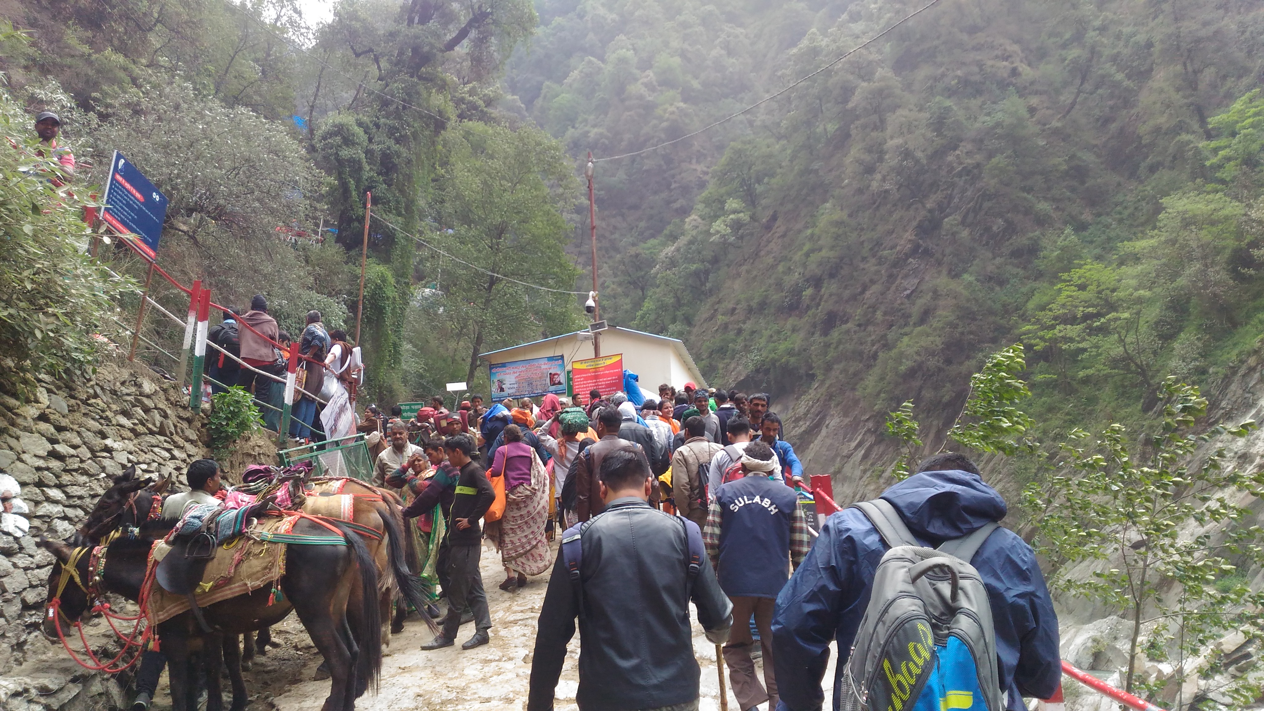
Kedarnath Is a Trek Before It Is a Temple Visit.
The road journey ends below the shrine. The current Uttarakhand portal describes a 16 km trek from Gaurikund to Kedarnath. Older government itineraries and older trail descriptions sometimes show different distances because the post-2013 route has changed over time; use the current official figure for planning, then verify local trail information on arrival.
The standard route is non-technical, but that does not make it trivial. You gain substantial elevation while moving toward about 3,580 m, often among heavy pilgrim traffic, ponies and rapidly changing weather. A light pack, early start, deliberate pace and willingness to turn around if health deteriorates matter more than hiking speed.
The Yatra Repeatedly Takes You Above 3,000 m.
The 2026 state health advisory explicitly treats Char Dham as high-Himalayan travel: all four pilgrimage sites are above 2,700 m, with low oxygen, cold and rapid weather change among the risks.
~3,293 m
The first dham already puts many lowland visitors at a meaningful altitude. The walk from Janki Chatti helps, but it is still possible to ascend too fast if you arrived from the plains only hours earlier.
~3,100 m
Road access can disguise the physiological jump. A car can gain altitude far faster than your body adapts, which is one reason the circuit order and overnight stops matter.
~3,580 m
The highest standard shrine stay in the circuit and the only one paired with a long uphill approach. Do not ignore headache, nausea, unusual breathlessness or confusion because the trip is religious rather than recreational.
~3,133 m
By the final dham, a well-paced road pilgrim has had several days of altitude exposure. That sequence is much more favorable than flying directly from low elevation for a brief visit.
Plan at Least Seven Days
The 2026 Uttarakhand health advisory specifically recommends planning a trip of at least seven days to allow acclimatization and taking regular breaks during trekking and automobile ascent.
Understand Acclimatization
If you do not routinely travel above 3,000 m, read Altitude Acclimatization Explained before building the schedule.
Register Before You Build the Rest of the Trip Around a Date.
The Uttarakhand system is part safety monitoring and part crowd management. Treat it as a core trip requirement, not paperwork to solve after arriving in the mountains.
Create the Yatra Online
The current Tourist Care Uttarakhand portal allows online registration through the website and official mobile app. Select the tour dates, the dhams and each intended visit date.
Download the Registration Letter
Keep the QR-linked registration certificate available on the phone and ideally offline. The portal tells pilgrims to have it ready at verification points.
Complete Shrine Verification
Verification counters operate at the dhams and along the route. Registration is a free government process; do not pay an unofficial intermediary simply to create the registration.
May–June and September–October Are the Strongest General Windows.
The pilgrimage season spans spring through autumn, but crowd levels, snow, monsoon rain and road stability change dramatically inside that broad window.
| Period | Typical character | Advantages | Main concern | Verdict |
|---|---|---|---|---|
| Opening weeks | Cold, residual snow, intense religious energy | First darshan period; dramatic mountains | Cold, crowds, weather variability | Meaningful but demanding |
| May–June | Spring into early summer | Strong access before monsoon; longer days | Peak crowds and traffic | Best overall |
| July–August | Monsoon | Lush valleys | Heavy rain, landslides, road disruption, slippery trails | Avoid if flexible |
| September | Post-monsoon transition | Cleaner air, improving roads, strong mountain views | Residual rain early; variable road repair | Excellent |
| October to closing | Cool to cold | Clearer air, often lower crowds | Shorter days, colder mornings, early snow possible | Excellent if cold-ready |

Haridwar and Rishikesh Give the Body—and the Pilgrimage—a Beginning.
The plains gateway is not wasted time. Starting low and climbing gradually through the valleys gives your body more time than flying into a short high-altitude itinerary. Uttarakhand’s 2026 health advisory asks pilgrims to plan, prepare and pack for high altitude: allow acclimatization time, take frequent breaks, carry warm and rain layers, bring prescribed medication, and seek medical help quickly for significant symptoms.
The advisory gives additional caution to older pilgrims and people with heart disease, hypertension, asthma, diabetes or obesity, and recommends a pre-trip health check when appropriate. A pilgrimage can be spiritually important without requiring you to ignore medical advice.
Road Travel Is the Backbone; Walking Defines Yamunotri and Kedarnath.
A full circuit mixes buses, shared or private vehicles and trekking. Helicopters change the time equation but not the mountain-weather reality.
Haridwar / Rishikesh Are the Natural Gateways
Uttarakhand’s own itineraries begin from these gateways and run through Barkot, Uttarkashi, the Mandakini valley, Joshimath and Badrinath. The official GMVN circuit currently lists more than 1,500 km of travel from Haridwar.
Two Standard Pilgrim Approaches
Yamunotri requires roughly 6 km from Janki Chatti on the current portal. Kedarnath requires roughly 16 km from Gaurikund. Gangotri and Badrinath are normally reached by road.
Ponies, Palkis and Helicopters
Assisted transport is part of the modern yatra system. Use official booking and local registration channels. Weather and crowd controls can suspend or delay services even when a ticket exists.
Price the Circuit by Transport Model, Not by Temple.
The temples themselves are not the expensive part. Vehicle type, hotel standard, Kedarnath lodging, assisted walking and helicopter use drive the trip budget.
| Cost layer | Budget road yatra | Private / comfort road yatra | Helicopter-heavy yatra |
|---|---|---|---|
| Transport | GMVN / bus / shared vehicle | Dedicated car or SUV | Charter/shuttle plus surface transfers |
| Lodging | Simple guesthouses / GMVN | Better hotels where available | Premium gateway lodging; mountain inventory still limited |
| Walking assistance | Mostly self-powered | Pony/palki as needed | May reduce walking but does not remove all transfers |
| Flexibility | Lower cost, less private control | Best ability to stop/recover | Highest sensitivity to flying weather |
This Pilgrimage Makes More Sense When the Mountains Are Not Treated as Scenery.
The Garhwal Himalaya carries layers of Hindu religious meaning in peaks, rivers, glaciers, valleys and shrines. Char Dham belongs naturally inside both the pilgrimage and sacred-mountain architectures of Global Summit Guide.
A Goddess, a Mountain and a Protected Sanctuary
Nanda Devi is one of the clearest examples of mountain geography and sacred identity overlapping in Uttarakhand. Read the Nanda Devi guide for the climbing history, sanctuary restrictions and cultural context.
Garhwal Is Also a Major Climbing Region
For the larger peak system surrounding the pilgrimage valleys, use the Indian Himalaya & Ladakh regional guide.
Go Beyond the Road Circuit Carefully
Gaumukh, Tapovan, Valley of Flowers, Hemkund and other routes turn pilgrimage travel into dedicated trekking. Use the Himalaya Trekking Peaks guide to think about altitude and route choice more broadly.

The Himalaya Is Not a Backdrop to the Religion.
Nanda Devi’s sacred identity, the source traditions of the Yamuna and Ganga, Shiva at Kedarnath and Vishnu at Badrinath all point to the same planning lesson: Char Dham is better understood as movement through a sacred mountain landscape than as four independent temple visits. That is why weather, altitude, road hardship and walking effort belong to the meaning of the journey rather than sitting outside it.
Pack for Cold, Rain, Long Road Days and One Serious Uphill Trek.
You do not need expedition equipment for the normal yatra. You do need clothing and footwear that still work when a warm valley day becomes a cold, wet evening above 3,000 m.
Broken-In Walking Shoes
Trail shoes or light hikers with reliable traction are enough for most standard routes. Do not introduce new footwear on the Kedarnath day.
Layer for a Cold Shrine Morning
Thermals, insulating jacket, warm hat, gloves and dry socks belong in the bag even when the plains are hot. This matches the state’s health-advisory packing guidance.
Shell + Pack Protection
Carry a rain shell and protect medication, electronics and warm layers inside the pack. An umbrella is useful in towns; a shell is more practical on a crowded mountain trail.
Medication + Simple Monitoring
Carry prescribed medication and the contact information you would need if a medical condition worsens. The current state advisory also includes a thermometer and pulse oximeter in its basic health-check equipment list.
Keep Kedarnath Light
Water, warm layer, rain shell, snacks, medication, registration/ID, phone and backup power are more useful than carrying the entire trip bag uphill.
Do Not Over-Pack
For broader mountain layering and safety principles, use Gear & Safety, then reduce the system to what this pilgrimage actually requires.
Use Uttarakhand’s Official Systems for Registration, Health and Current Access.
Opening dates, registration rules, road controls and helicopter procedures are operational information. Recheck them close to travel rather than relying on an old itinerary.
Tourist Care Uttarakhand
Official registration, verification, vehicle information, current dham pages and pilgrim support.
Open official registration →Uttarakhand Tourism
Destination guidance, official itineraries, GMVN packages and regional travel information.
Open Uttarakhand Tourism →BKTC
Kedarnath and Badrinath temple services, current yatra notices and official helicopter-booking direction.
Open temple committee →2026 Char Dham Health Advisory
Current high-altitude preparation, warning symptoms, health touchpoints and medical precautions.
Open health guidance →Pilgrimage Trails of the World
Compare Char Dham with Camino, Kumano, Via Francigena, Shikoku and other major pilgrimage systems.
Compare world pilgrimages →Sacred Mountains of the World
Place the Garhwal pilgrimage inside the global relationship between religion, mountain geography and sacred summits.
Explore sacred mountains →Char Dham Yatra FAQ
What are the four sites of the Uttarakhand Char Dham?
Yamunotri, Gangotri, Kedarnath and Badrinath. This circuit is often called Chota Char Dham to distinguish it from the separate pan-India Char Dham tradition.
How many days do I need?
About 10–12 days is a strong road-based plan from Haridwar or Rishikesh. Uttarakhand Tourism currently lists a 10-day, 10-night GMVN itinerary; adding one or two days creates more useful weather and health margin.
How long is the Kedarnath trek?
The current Uttarakhand pilgrimage portal states that the road journey ends at Gaurikund and the trek to Kedarnath is about 16 km. Verify current routing before the walking day because trail lines and access controls can change.
Is registration mandatory?
Yes. The official portal states registration is compulsory, free, and linked to destination verification. Carry the registration certificate/QR information.
What are the 2026 opening dates?
The official portal lists Yamunotri and Gangotri opening April 19, Kedarnath April 22 and Badrinath April 23, 2026. Recheck current closure dates and operating conditions before travel.
What is the best time?
May–June and September–October are the strongest general windows. July–August monsoon can bring heavy rain, landslides and road disruption; late-season travel becomes progressively colder.
Do I need to worry about altitude?
Yes. All four shrines are above 2,700 m and Kedarnath is around 3,580 m. The 2026 state health advisory recommends allowing acclimatization time, taking frequent breaks and seeking medical advice when appropriate.
Can I fly to Kedarnath?
Seasonal helicopter shuttle services operate, subject to weather and availability. Use the official channels referenced by the Badrinath-Kedarnath Temple Committee and IRCTC HeliYatra rather than unverified sellers.
Place Char Dham Inside the Larger Pilgrimage—and Sacred-Mountain—Network.
The Uttarakhand circuit combines religious journey, high-altitude travel and sacred mountain geography in a way few other major pilgrimages do.
Give the Yatra Enough Time to Be a Pilgrimage, Not a Race Between Four Gates.
Begin low in Haridwar or Rishikesh. Follow the traditional west-to-east sequence. Let Yamunotri and Gangotri introduce the altitude before Kedarnath asks for the hardest walking day. Protect a real weather-and-recovery buffer before Badrinath. Register through the official Uttarakhand system, follow the health guidance, and remember that the mountains, rivers, roads and physical effort are part of the journey’s meaning. Char Dham is at its strongest when the logistics support the pilgrimage rather than overpower it.
Was this helpful?
🏔Related peaks nearby
🧭Explore & compare
Global Summit Guide is an independent mountaineering resource founded in 2026. The team combines first-hand trekking and climbing experience with in-depth research and professional health and nutrition review to help climbers choose objectives, prepare properly, and stay safe.
Health, altitude, and nutrition content is reviewed by Taylor Ludlow (Registered Nurse) and Brigg Hoopes (Nutritionist).
What We Don't Know Yet
Mountain information changes quickly. This box explains the limits of what this page can responsibly promise.
- Visa, passport, vaccination, border, insurance, and local transportation rules may change before your trip.
- Route conditions, snowpack, closures, and weather can change quickly after this page is updated.
- Permit rules, fees, quotas, and reservation windows may change between review cycles.
- Operator availability, pricing, guide ratios, and cancellation terms can change by season.
- Your fitness, altitude response, risk tolerance, and experience level may change what is safe or realistic.
Verify current conditions with official land managers, guide services, local forecasts, and current route reports before booking or climbing.
Mountaineering, rock and ice climbing, glacier travel, and high-altitude activity are inherently dangerous and can result in serious injury or death. The information on Global Summit Guide is provided for general informational and educational purposes only and is not a substitute for professional instruction, qualified guiding, proper equipment, or your own judgment and experience.
Route conditions, weather, snowpack, permits, regulations, and hazards change constantly and may differ from what is described here. Details may be incomplete, out of date, or contain errors. Always verify current information with local authorities, certified guides, and official sources before making any decision in the mountains.
Nothing on this site is medical, legal, or financial advice. Our fitness, acclimatization, altitude, and nutrition content is general in nature; consult a qualified physician before beginning any strenuous exercise program or exposing yourself to high altitude.
You are solely responsible for your own safety and decisions. To the fullest extent permitted by law, Global Summit Guide and its team accept no liability for any loss, injury, damage, or expense arising from use of, or reliance on, this information. By using this site you acknowledge these risks and accept these terms.
Some links on this site may be affiliate links. If you buy through them we may earn a small commission at no extra cost to you; this never affects our recommendations.
Global Summit Guide recommendation path
Next Best Mountain to Research
Use these recommendations to continue the right planning path instead of stopping on one page.
Use current permit, weather, route, and operator information before booking or climbing.
Search Flights, Hotels & Rental Cars
Have the mountain or destination picked? Use Expedia to compare the flights, lodging and rental cars that fit your actual trip dates. For mountain travel, consider arriving early enough for delays and adding a buffer night after the climb before a fixed flight home.
Compare current flight, hotel and car options.
Affiliate disclosure: Global Summit Guide may earn a commission if you book through this link, at no additional cost to you.