
Climbing Kamet: The Complete 2026 Meade’s Col Route, Niti Village & Garhwal Himalaya Guide
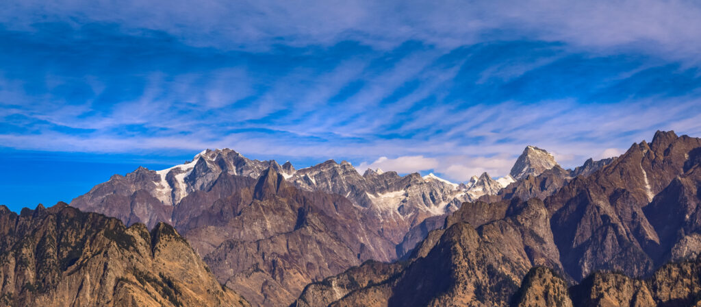
Kamet rises to 7,756 m (25,446 ft) above the Garhwal Himalaya as the second highest peak in Uttarakhand after Nanda Devi. Furthermore, the peak holds the historic distinction as the first mountain over 25,000 ft (7,620 m) ever climbed by humans, achieved in 1931 by Frank Smythe’s British expedition.
However, the peak’s reputation extends beyond mere elevation. Specifically, Kamet ranks as the 29th highest mountain in the world. Subsequently, the peak features a distinctive pyramid shape with a flat summit area containing two distinct points connected by a knife-edge ridge.
The mountain sits in the remote Chamoli District near the Tibetan border, surrounded by three glacier systems. Moreover, the Paschim Kamet glacier flows west, the Purbi Kamet glacier flows east, and the Raikana glacier system extends northward. Additionally, the peak’s position near the Tibetan Plateau exposes climbers to severe wind throughout expeditions.
Beyond the climbing achievement, the 1931 expedition discovered the famous Valley of Flowers during descent. Notably, Frank Smythe and R.L. Holdsworth named the now-protected national park during their return to base camp. Additionally, this discovery added scientific significance to the historic mountaineering accomplishment.
Today, Kamet remains the highest accessible peak in the Garhwal Himalaya since Nanda Devi closed in 1983. Specifically, expeditions take 28-30 days from Delhi via Joshimath to Niti Village base camp. Furthermore, the standard route follows the East Kamet Glacier to Meade’s Col, the col dividing Kamet from Eastern Abi Gamin.
This complete 2026 guide covers verified route descriptions, current permit requirements, gear lists, hazard analysis, seasonal timing, costs across budget tiers, expedition history, and essential safety protocols. Furthermore, every detail reflects 2026 conditions confirmed through Indian Mountaineering Foundation and registered Indian operators.
Live Kamet Operations Center
Real-time location intelligence and Niti Village base region weather conditions
Kamet stands as the burning mountain of the Garhwal Himalaya, rising 7,756 meters above the remote Chamoli District near the Tibetan border. Furthermore, the peak ranks as the second highest mountain in the Garhwal Himalaya after the closed Nanda Devi.
However, the peak’s significance extends well beyond mere elevation. Specifically, Kamet became the first mountain over 25,000 ft (7,620 m) ever climbed by humans on June 21, 1931. Subsequently, Frank Smythe’s British expedition held the world altitude climbing record until Nanda Devi was climbed five years later.
The mountain features a distinctive pyramid shape with a flat summit area containing two distinct points. Moreover, the summit ridge runs as narrow as a single person can walk on knife-like edge. Additionally, the summit slope on the north falls steeply to Meade’s Col while the south falls gently to the southern rock precipice.
Despite ranking 29th highest in the world, Kamet provides relatively straightforward technical climbing for such high altitude. Notably, the established route via East Kamet Glacier and Meade’s Col remains the standard approach used since 1931. Most expeditions take 28-30 days from Delhi via Joshimath to summit and return.
Beyond the climbing achievement, Kamet’s 1931 expedition also discovered the famous Valley of Flowers during descent. Additionally, this protected national park became a UNESCO World Heritage Site in 1988. Furthermore, the discovery added scientific significance to the historic mountaineering accomplishment by Smythe and R.L. Holdsworth.
First climbed in 1931 and second climbed by an Indian expedition in 1955, Kamet has since hosted numerous notable expeditions including the 2008 Japanese first ascent of the Southeast Face. Subsequently, the peak remains one of the most respected Himalayan objectives accessible to international climbers. Today, Kamet represents the highest accessible peak in the Garhwal Himalaya for serious 7,000+ m mountaineering.
The Meade’s Col route from Niti Village remains the recommended approach for most expeditions. Specifically, this route follows the historic 1931 first ascent line via East Kamet Glacier. Furthermore, the established camp progression at 5 high camps provides safe acclimatization. Additionally, the route rewards climbers with an iconic Himalayan summit experience including panoramic views of the Garhwal range and Tibetan Plateau.
Kamet receives extreme wind from the nearby Tibetan Plateau throughout climbing season. Specifically, devastating winds can tear camps apart in mere seconds at higher elevations. Moreover, climbers must time movements around stable weather windows carefully. Additionally, the narrow summit ridge demands extreme caution in windy conditions. Therefore, conservative weather assessment and proper tent selection remain absolutely essential for safe expeditions.
This guide consolidates information from the Indian Mountaineering Foundation (IMF), Uttarakhand state forest department, Frank Smythe’s “Kamet Conquered” expedition memoir, the Himalayan Journal historical archives, registered Indian operators including Kahlur Adventures, Alpine India Expeditions, and Himalayan Adventure Trips, and verified expedition reports. Additionally, all elevations, route grades, costs, and permit requirements reflect 2026 conditions confirmed through April 2026.
At a Glance: Kamet Essentials
Kamet presents specific characteristics among the major Garhwal Himalaya peaks. Furthermore, the following statistics summarize what climbers must prepare for. Specifically, every parameter below reflects 2026 conditions verified through Indian Mountaineering Foundation and registered Indian operators.
Eight Reasons Climbers Choose Kamet
Kamet holds a unique position in mountaineering history and Indian Himalaya climbing culture. Furthermore, the following reasons explain why serious alpinists target this peak. Importantly, each motivation also carries an associated responsibility for safe execution at extreme altitude.
First 25,000 ft Peak Ever Climbed
Kamet became the first mountain over 25,000 ft (7,620 m) climbed by humans in 1931. Furthermore, this historic achievement held the world altitude climbing record until Nanda Devi was climbed in 1936.
Highest Accessible Garhwal Peak
Kamet ranks as the second highest peak in the Garhwal Himalaya after the closed Nanda Devi. Subsequently, this makes Kamet the highest accessible peak in the Garhwal region for serious expeditions.
29th Highest Mountain in World
Kamet stands as the 29th highest mountain in the world. Specifically, this places it among the elite high-altitude objectives outside the famous 8,000 m fourteen.
Burning Mountain Legend
The name Kamet derives from Tibetan Kangmed meaning the lower snows. Additionally, the term glacier fire describes the orange glow when sun rays hit the copper-colored rock at dawn and dusk.
Frank Smythe Climbing History
Frank Smythe’s classic book “Kamet Conquered” documents the historic 1931 first ascent. Moreover, this account remains essential reading for serious Himalayan climbers and historians.
Valley of Flowers Discovery
The 1931 Smythe expedition discovered the famous Valley of Flowers during descent. Subsequently, this protected national park became a UNESCO World Heritage Site in 1988.
Remote Tibetan Border Setting
Kamet sits in the remote Chamoli District near the Tibetan border. Notably, this position creates dramatic wind exposure but also incredible Tibetan Plateau views from the summit.
Combination with Abi Gamin
Many expeditions combine Kamet with neighboring Abi Gamin (7,355 m). Furthermore, both peaks share the East Kamet Glacier approach and Meade’s Col base camp infrastructure.
Who Can Climb Kamet
Kamet demands serious high-altitude mountaineering experience. Specifically, the standard Meade’s Col route requires solid 7,000+ m experience, glacier travel skills, and tolerance for sustained wind exposure. Furthermore, climbers should have prior Himalayan expedition experience or join a fully guided team with experienced Sherpas.
The standard route gains approximately 4,000 m from Niti Village base camp to the summit. Therefore, a climber comfortable with multi-week expedition logistics has the foundation for Kamet. However, raw fitness alone will not protect against altitude effects, weather changes, or technical demands at extreme altitude.
Beginners to high-altitude expeditions should not target Kamet. Subsequently, the peak requires substantial 8000-meter style logistics and technical climbing experience. Importantly, completing prior 6,000 m and 7,000 m peaks provides essential preparation for Kamet attempts.
For climbers with strong Himalayan backgrounds, Kamet provides excellent preparation for harder objectives like K2 or Everest. Moreover, the multi-camp expedition style mirrors 8,000 m climbing logistics. Additionally, the demanding wind exposure builds critical weather decision-making skills for future expeditions.
The IMF emphasizes that all Kamet permits require advance coordination through registered Indian operators. Notably, operators like Kahlur Adventures send their most experienced Sherpa team for Kamet expeditions with 3:4 climber-to-Sherpa ratios. Furthermore, the Sherpa team handles fixed rope installation and route opening above base camp. Therefore, partnering with established Indian operators provides essential expedition support throughout the multi-week climb.
Kamet in Garhwal Himalaya Context
Kamet occupies a strategic position as the northernmost major peak of the Garhwal Himalaya. Specifically, the peak rises in the remote Chamoli District near the Tibetan border. Additionally, the mountain dominates the ranges of Northern Garhwal, second only to the closed Nanda Devi.
For climbers planning regional trips, Kamet pairs naturally with several nearby Garhwal peaks. Furthermore, Abi Gamin (7,355 m) shares the East Kamet Glacier approach. Additionally, Mana Peak (7,272 m) provides another nearby objective in the same valley system. Moreover, Mukut Parbat (7,242 m) offers an alternative via similar approach logistics.
The Garhwal Himalaya Companion Peaks
Kamet shares the Garhwal Himalaya with several other classic Indian peaks. Furthermore, all six peaks below provide alternative or progression objectives accessible from Joshimath base region.
Kamet History: From 1855 Attempts to Modern Expeditions
Kamet’s recorded climbing history spans over 170 years and reflects significant chapters in Himalayan exploration. Ultimately, few peaks combine such legendary first ascent record with continued modern accessibility. Specifically, the mountain played a foundational role in establishing high-altitude climbing techniques and Garhwal Himalaya exploration.
1855: First Climbing Attempts
Climbing attempts on Kamet began as early as 1855. Specifically, this reflects the mountain’s early recognition as a significant Himalayan challenge. Additionally, the technical difficulties, extreme remoteness, and harsh weather conditions prevented success for over seven decades. Furthermore, early expeditions faced 200-mile approach marches from Ranikhet through dense mountain forest.
Late 19th Century: Survey Work
Mount Kamet first caught the attention of British surveyors and explorers in the late 19th century. Specifically, reconnaissance missions by W.W. Graham and Dr. Tom Longstaff helped map approaches and identify viable routes. Additionally, these early explorations established the foundation for future climbing attempts. Furthermore, the surveys documented the unique pyramid shape and twin summit configuration.
Early 20th Century: Meade Establishes Route
C.F. Meade made critical contributions establishing the East Kamet glacier route. Specifically, Meade proved the summit accessible provided that a camp could be established on the col dividing Kamet from Eastern Abi Gamin. Additionally, Meade demonstrated that sufficient stores could be dumped at this col to allow for adverse weather delays. Subsequently, this route became known as Meade’s Col and remains the standard approach today.
June 21, 1931: Historic First Ascent
Frank Smythe led the first successful ascent on June 21, 1931. Specifically, the summit team consisted of Smythe, Eric Shipton, R.L. Holdsworth, and Lewa Sherpa. Additionally, the British expedition included Raymond Greene (doctor), Bill Birnie, and E.B. Beauman. Furthermore, this made Kamet the first peak over 25,000 ft (7,620 m) ever climbed by humans, holding the world altitude record until 1936.
1931 Descent: Valley of Flowers Discovery
Frank Smythe and R.L. Holdsworth discovered the famous Valley of Flowers during descent from Kamet. Specifically, the team named the valley for its spectacular alpine flora. Additionally, the discovery added scientific significance to the historic mountaineering accomplishment. Subsequently, the Valley of Flowers became a UNESCO World Heritage Site in 1988.
July 6, 1955: Indian Second Ascent
An Indian expedition from the Himalayan Mountaineering Institute in Darjeeling made the second ascent on July 6, 1955. Specifically, Nandu Jayal led the party with summit team Jayal, Ang Tharkay, Da Namgyal, Ang Temba, and Hlakpa Dorje. Additionally, their route followed the ridge linking Abi Gamin and Kamet. Subsequently, this established Indian climbing capability on the country’s highest accessible peak.
1937: Frank Smythe Returns
Frank Smythe returned to the Bhyundar Valley in 1937 making the solo first ascent of Mana Peak. Specifically, the climb on August 12, 1937 followed the south ridge from the plateau at the head of the Uttari Naktoni glacier. Additionally, his companion P.R. Oliver stopped exhausted at 23,000 ft. Furthermore, this ascent demonstrated Smythe’s continued commitment to Garhwal exploration.
October 3, 2000: Millennium Ascent
The Ruptaps Mountaineering Club from Asansol, West Bengal climbed Kamet on October 3, 2000 to mark the turn of the century. Specifically, the summiteers were leader Gautam Mukherjee and Jasjeet Singh. Additionally, this commemorative ascent celebrated India’s growing high-altitude climbing tradition. Subsequently, Indian club expeditions have continued regular Kamet activity.
2006: 75th Anniversary Expedition
The Kolkata Section of the Himalayan Club organized a commemorative 75th anniversary expedition that put ten climbers on the summit of Kamet. Specifically, this expedition celebrated Frank Smythe’s 1931 first ascent. Additionally, the mass summit demonstrated modern Indian organizational capability. Furthermore, the success honored Smythe’s status as a Himalayan Club member.
2008: Japanese Southeast Face First Ascent
Japanese climbers Kazuya Hiraide and Kei Taniguchi made the first ascent of the 6,000 ft southeast face in 2008. Specifically, the team named their new route Samurai Direct. Additionally, the route featured difficulties up to M5+ and AI5+. Furthermore, the Japanese descended via the normal route over two more days, demonstrating modern Alpine-style achievement on Kamet.
Climbing Routes on Kamet
Kamet features several established climbing routes across its glaciated aspects. Specifically, the Meade’s Col route via East Kamet Glacier dominates climbing traffic. Furthermore, the Abi Gamin Ridge route, the technical Southeast Face Samurai Direct, and various combination tours provide alternatives for experienced alpinists. Additionally, all routes require IMF permits and registered operator coordination.
| Route | Approach | Grade | First Ascent | Time | Camps |
|---|---|---|---|---|---|
| Meade’s Col (Standard) | East Kamet Glacier | D | 1931 Smythe | 28-30 days | 5 high camps |
| Abi Gamin Ridge | From Abi Gamin | D | 1955 Indian | 30-32 days | 5-6 high camps |
| Southeast Face (Samurai Direct) | Direct face | TD+ / M5+ AI5+ | 2008 Japanese | 5-7 days | Alpine style |
| Northeast Slopes | Variable | D | Various | 28-30 days | 5 high camps |
Meade’s Col Route — East Kamet Glacier
The Meade’s Col Route represents the standard climbing approach on Kamet. Specifically, climbers begin from Joshimath via Bampa village, Malari, and Niti Village (3,300 m). Moreover, the approach trek takes 4-5 days through traditional Garhwali villages. Additionally, base camp is established at Vasundhara Tal at approximately 4,725 m.
From base camp, the route follows the East Kamet Glacier through moraine fields and glacial terrain. Subsequently, expeditions establish 5 high camps at progressively higher elevations. Additionally, the team practices climbing equipment use and conducts acclimatization hikes. Furthermore, this section provides the foundation for the demanding summit push above 7,000 m.
The route ascends to Meade’s Col, the col dividing Kamet from Eastern Abi Gamin at approximately 7,138 m. Additionally, this critical waypoint was first established by C.F. Meade as the key access to the upper mountain. Notably, climbers stash supplies at the col for the final summit push. Consequently, Meade’s Col serves as the strategic high point before the summit attempt.
The summit ridge runs as a narrow knife-edge requiring single-file movement. Moreover, the summit slope on the north falls steeply to Meade’s Col while the south falls gently to the southern rock precipice. Notably, lack of oxygen at altitude seriously hampers climbers throughout the summit push. Consequently, the Meade’s Col route stands as the safest established Kamet ascent line, requiring exceptional fitness and acclimatization.
Abi Gamin Ridge — From Eastern Abi Gamin
The Abi Gamin Ridge route approaches Kamet via the connecting ridge to neighboring Abi Gamin (7,355 m). Specifically, this route was used by the 1955 Indian second ascent led by Nandu Jayal. Additionally, the approach allows climbers to attempt both peaks during a single expedition.
This route requires longer expedition timelines than the standard approach. Furthermore, the ridge traverse adds technical complexity to the climb. Additionally, the dual peak attempt rewards climbers with two summits but demands additional acclimatization. Consequently, the Abi Gamin Ridge suits experienced expedition teams seeking maximum value from their permit and operator coordination.
Southeast Face — Samurai Direct (Japanese 2008)
The Southeast Face Samurai Direct route represents modern Alpine-style climbing on Kamet. Specifically, the route was first climbed in 2008 by Japanese climbers Kazuya Hiraide and Kei Taniguchi. Additionally, the face features 6,000 ft of sustained vertical mixed climbing. Notably, the route includes difficulties up to M5+ and AI5+ throughout.
This route demands elite Alpine climbing skills at the TD+ grade level. Furthermore, the climb requires technical ice tools, ice screws, and rock protection throughout. Additionally, climbers must possess solid mixed climbing experience comparable to Patagonian or Karakoram alpinism. Consequently, the Samurai Direct represents a serious objective only for top international Alpine climbers.
Northeast Slopes — Acclimatization and Variations
The Northeast Slopes provide variation routes used historically for acclimatization. Specifically, Hiraide and Taniguchi acclimatized on the northeastern slopes before their 2008 Samurai Direct attempt. Additionally, these slopes connect to the standard Meade’s Col route through various traverse options.
This area offers training routes for serious expedition teams. Furthermore, the variations help climbers acclimatize properly before harder summit attempts. Additionally, the northeastern aspect provides shelter from prevailing Tibetan Plateau winds. Consequently, this area serves modern teams attempting technical lines or seeking superior acclimatization on Kamet.
Kamet Access & Permits 2026
Kamet requires comprehensive permits in 2026 due to its position near the Tibetan border. Specifically, all climbers need Indian Mountaineering Foundation permits, Uttarakhand state permits, and Inner Line Permits for foreign nationals. Furthermore, the IMF processes climbing permits in coordination with the Forest Department and Indo-Tibetan Border Police.
Kamet permits require advance application 3-4 months before expedition. Specifically, the IMF coordinates with multiple agencies due to the peak’s border location. Additionally, foreign nationals need Inner Line Permits processed separately. Moreover, registered Indian operators handle the full permit coordination including Liaison Officer assignment. Furthermore, the climbing season runs primarily April through October with weather windows in May-June and September-October.
Required Documentation for 2026
- IMF climbing permit: Indian Mountaineering Foundation expedition permit
- Uttarakhand forest permit: State-level access permit for Garhwal Himalaya
- Inner Line Permit: Required for foreign nationals due to Tibet border
- Liaison Officer: IMF-assigned officer accompanies all expeditions
- Registered operator coordination: Mandatory for all climbing expeditions
- High-altitude insurance: Mandatory including helicopter rescue coverage
- Indian visa: Tourist or expedition visa for foreign climbers
2026 Permit Cost Breakdown
- IMF climbing permit: USD 2,500-4,000 per expedition
- Uttarakhand forest permit: USD 300-500 per expedition
- Inner Line Permit: Approximately USD 50 per foreign national
- Liaison Officer fees: USD 2,000-3,000 for full expedition duration
- Registered operator base fees: USD 12,000-25,000 per climber depending on services
- High-altitude insurance: USD 800-1,500 per climber minimum
Access Logistics from Delhi
Kamet is accessible from Delhi via train and road. Specifically, expeditions typically take overnight train from Delhi to Haridwar or Rishikesh, then road transfer through Joshimath to Bampa Village and Niti Village. Additionally, the journey to base camp requires 7-8 days of approach trekking through traditional Garhwali villages. Moreover, Niti Village serves as the last inhabited settlement before base camp at Vasundhara Tal. Consequently, plan substantial travel time including IMF de-briefing in Delhi at expedition end.
Kamet Climbing Costs in 2026
Kamet expedition costs vary based on guide service level and team size. Specifically, fully guided expeditions run USD 20,000-35,000 per person. Furthermore, group rates with 4-6 climbers reduce per-person costs significantly. Additionally, all costs reflect 2026 conditions verified through registered Indian operators including Kahlur Adventures and Alpine India Expeditions.
Group Guided Kamet Expedition (6+ climbers)
The most affordable Kamet expedition option involves group climbs with 6 or more climbers per registered Indian operator. Furthermore, costs include IMF permits, Liaison Officer fees, registered operator services, climbing guides, high-altitude Sherpas, fixed ropes, food, and base camp logistics. Specifically, this tier provides solid value for clubs and larger teams attempting Kamet together.
Standard Guided Expedition (4-5 climbers)
Most international climbers select the standard guided expedition format. Additionally, this tier provides personalized attention with a 3:4 Sherpa-to-climber ratio used by experienced operators like Kahlur Adventures. Specifically, the cost includes complete logistics from Delhi reception through expedition completion. Furthermore, this represents the typical cost for serious Kamet attempts.
Premium Small Team Expedition (2-3 climbers)
Premium small team expeditions provide higher Sherpa-to-climber ratios for maximum support. Additionally, this tier includes priority weather forecasting, premium gear options, and enhanced base camp facilities. Notably, smaller teams move more efficiently through high camps. Consequently, this option suits experienced climbers seeking optimal support for personal Kamet success.
Kamet plus Abi Gamin Combination
The Kamet plus Abi Gamin (7,355 m) combination offers two 7,000+ m peaks during a single expedition. Moreover, the combined approach uses shared infrastructure on the East Kamet Glacier. Subsequently, climbers maximize their permit and operator coordination investment. Additionally, the dual summit attempt requires extended timeline but provides exceptional value for fit climbers.
Custom Private Expedition
Custom private expeditions provide maximum flexibility and luxury services. Furthermore, climbers can tailor schedules, route choices, and base camp facilities. Notably, this includes options for technical routes like the Samurai Direct or alternate seasonal windows. Consequently, custom expeditions suit experienced alpinists seeking specific Kamet experiences beyond standard packages.
Essential Gear for Kamet Expedition
Gear requirements for Kamet reflect serious 7,000+ m expedition demands. Specifically, the standard Meade’s Col route requires full high-altitude expedition equipment. Furthermore, climbers should bring quality gear suitable for 28-30 day expedition conditions with extreme Tibetan Plateau wind exposure. Additionally, every essential item below reflects current Indian Mountaineering Foundation expedition standards.
High-Altitude Boots (Mandatory)
- Triple-layer boots rated for -40°C minimum
- La Sportiva Olympus Mons or Scarpa Phantom 8000
- Compatible with 12-point automatic crampons
- Break in thoroughly before expedition
Climbing Hardware (Mandatory)
- 12-point automatic crampons
- Two technical ice axes for steep sections
- Climbing harness with adjustable leg loops
- Ascender (jumar) for fixed ropes
Ropes & Protection (Mandatory)
- 60-meter dynamic glacier rope (8.5-9 mm)
- 4-6 ice screws (varied lengths 13-19 cm)
- Snow pickets and pitons
- Fixed rope coordination via operator Sherpa team
Down Suit and Insulation
- Full down suit for summit push
- 800-fill or higher down rating
- Synthetic backup insulation layer
- Down booties for camp use
Sleeping System
- Sleeping bag rated to -40°C minimum
- Closed-cell foam pad plus inflatable
- Vapor barrier liner for warmth
- Quality pillow for high-altitude rest
Tents and Shelter
- Wind-resistant high-altitude tents (provided by operator)
- Personal sleeping pad and bivy options
- Down booties and camp slippers
- Personal entertainment for weather days
Navigation and Safety
- GPS device or smartphone with offline maps
- Topographic maps of Kamet region
- Headlamp with multiple battery sets
- Satellite communicator (InReach mandatory)
Personal and Medical
- Comprehensive expedition first aid kit
- Diamox for altitude prophylaxis
- Personal medications for full duration
- Sunscreen SPF 50+ and lip protection
Hazards on Kamet
Kamet presents serious hazards typical of remote 7,000+ m Himalayan peaks. Specifically, extreme wind exposure from the nearby Tibetan Plateau accounts for many documented incidents. Furthermore, climbers must assess each hazard category honestly before any Kamet expedition.
Tibetan Plateau Wind Exposure
Kamet receives extreme wind from the nearby Tibetan Plateau throughout climbing season. Specifically, devastating winds can tear camps apart in mere seconds at higher elevations. Furthermore, climbers must time movements around stable weather windows. Moreover, even moderate winds become dangerous on the narrow summit ridge.
Crevasse Hazards on East Kamet Glacier
The East Kamet Glacier contains extensive crevasse fields requiring careful rope team travel. Specifically, snow bridges become unstable during warm weather and afternoon melt cycles. Furthermore, climbers must travel as roped parties throughout all glacier sections. Moreover, advanced crevasse rescue knowledge represents an absolute prerequisite for any climb.
Avalanche Risk from Mana Peak Area
Huge ice walls overhang the East Kamet Glacier from the Mana Peak ridge to the south. Specifically, ice avalanches thunder down these walls almost continuously during warmer days. Additionally, parties must time movements between camps around safe windows. Subsequently, the famous 1931 expedition documented this hazard extensively.
Altitude Effects Above 7,000 m
The 7,756 m summit elevation causes severe altitude effects. Furthermore, climbers must acclimatize through 5 high camps over weeks. Specifically, supplemental oxygen is recommended above 7,000 m for safety margin. Therefore, multi-week expedition schedules with proper acclimatization rotations are essential.
Narrow Knife-Edge Summit Ridge
The summit ridge runs as narrow as a single person can walk on knife-like edge. Moreover, the summit slope on the north falls steeply to Meade’s Col. Additionally, the south side falls gently to the southern rock precipice. Subsequently, ridge travel demands extreme caution and excellent rope team protocol.
Monsoon and Weather Variability
The Indian monsoon affects Kamet region from late June through August. Moreover, pre-monsoon (May-June) and post-monsoon (September-October) provide the climbing windows. Additionally, weather changes rapidly above 6,000 m. Furthermore, the 2014 Kolkata expedition failed due to prolonged bad weather forcing food rationing issues.
Safety Protocols for Kamet
Successful Kamet expeditions depend on conservative decision-making and disciplined execution. Furthermore, the most experienced Indian operators emphasize that turning back is a victory when conditions deteriorate. Specifically, climbers should establish hard turnaround times and honor them regardless of summit proximity.
File detailed itineraries with both your registered Indian operator and embassy. Additionally, carry comprehensive satellite communications including InReach for emergency response. Notably, Indian Air Force coordinates high-altitude rescue operations through Indian Mountaineering Foundation channels. Furthermore, knowing advanced crevasse rescue and partner-rescue techniques can mean the difference between minor incidents and fatal outcomes at extreme altitude.
When to Climb Kamet
Seasonal timing on Kamet determines both safety and success rates. Specifically, the Indian monsoon dominates climate considerations from late June through August. Furthermore, the climbing windows fall in pre-monsoon and post-monsoon periods, requiring careful attention to monthly conditions.
Spring Pre-Monsoon (April to early June)
Late spring offers the primary pre-monsoon climbing window. Furthermore, snow conditions remain firm and stable from winter accumulation. Specifically, this period provides the best weather windows for technical climbing on Kamet. Additionally, daytime temperatures remain manageable at lower elevations during the approach.
Monsoon Period (Late June to August)
The Indian monsoon shuts down most climbing activity on Kamet. Moreover, heavy precipitation and unstable weather make summit attempts dangerous. However, base camp and lower acclimatization activities can proceed during weather windows. Furthermore, the monsoon period sees minimal expedition activity in the Garhwal Himalaya.
Post-Monsoon (September to October)
The post-monsoon period provides the second major climbing window. Notably, stable high-pressure systems often bring excellent climbing weather. Subsequently, this period also rewards climbers with longer daylight than spring. Additionally, autumn provides clearer Tibetan Plateau views from the summit.
Winter (November to March)
Winter conditions effectively close Kamet to expedition activity. Furthermore, extreme cold and devastating Tibetan Plateau winds make climbing unrealistic. However, the famous 1931 first ascent occurred in late June, demonstrating early summer’s potential. Additionally, modern winter ascents have been attempted but remain extremely rare and dangerous.
Notable Expeditions and Climbs
Kamet’s climbing history features remarkable individual achievements alongside the famous 1931 first ascent. Furthermore, each notable expedition below contributed essential knowledge to modern Kamet climbing practice. Specifically, the expeditions span over 95 years of evolving Indian Himalaya mountaineering culture.
Smythe Historic First Ascent
First AscentFrank Smythe led the first successful ascent with summit team Smythe, Eric Shipton, R.L. Holdsworth, and Lewa Sherpa. Specifically, this made Kamet the first peak over 25,000 ft ever climbed by humans. Additionally, the expedition discovered the Valley of Flowers during descent.
Indian Second Ascent
Second AscentNandu Jayal led an Indian expedition from Darjeeling to the second ascent. Specifically, the summit team consisted of Jayal, Ang Tharkay, Da Namgyal, Ang Temba, and Hlakpa Dorje. Furthermore, their route followed the ridge linking Abi Gamin and Kamet.
Smythe Returns to Garhwal
Solo First AscentFrank Smythe returned to make the solo first ascent of Mana Peak (7,272 m) via the south ridge. Additionally, his companion P.R. Oliver stopped exhausted at 23,000 ft. Furthermore, this ascent demonstrated Smythe’s continued commitment to Garhwal Himalaya exploration.
Millennium Ascent
Century MarkThe Ruptaps Mountaineering Club from Asansol climbed Kamet to mark the turn of the century. Specifically, summiteers Gautam Mukherjee and Jasjeet Singh reached the top on October 3, 2000. Furthermore, this celebrated India’s growing high-altitude climbing tradition.
75th Anniversary Mass Ascent
Ten Climbers SummitThe Kolkata Section of the Himalayan Club organized a commemorative 75th anniversary expedition that put ten climbers on the summit. Additionally, this celebrated Frank Smythe’s 1931 first ascent and his Himalayan Club membership. Subsequently, the mass summit demonstrated modern Indian organizational capability.
Japanese Samurai Direct
First SE FaceKazuya Hiraide and Kei Taniguchi made the first ascent of the 6,000 ft southeast face. Specifically, they named the route Samurai Direct with difficulties up to M5+ and AI5+. Furthermore, the team descended via the normal route over two more days, demonstrating modern Alpine-style achievement.
Planning Your 2026 Kamet Expedition
Successful Kamet planning combines logistics, training, and conditioning across multiple months. Furthermore, the following planning categories cover every essential element climbers must address. Additionally, each card represents a critical preparation area for any 2026 attempt.
Kamet Frequently Asked Questions
How tall is Kamet?
Kamet rises to 7,756 m (25,446 ft) in the Garhwal Himalaya region of Uttarakhand, India. Specifically, the peak ranks as the second highest mountain in the Garhwal Himalaya after the closed Nanda Devi (7,816 m). Furthermore, Kamet stands as the 29th highest mountain in the world. Additionally, the peak features a unique pyramid shape with a flat summit area containing two distinct points connected by a knife-edge ridge.
Where is Kamet located?
Kamet sits in the Chamoli District of Uttarakhand, India, near the Tibetan border. Specifically, the peak rises in the remote northern extremity of the Garhwal Himalaya. Additionally, the mountain is surrounded by the Paschim Kamet glacier in the west, Purbi Kamet in the east, and the Raikana glacier system. Furthermore, base camp approaches typically begin from Niti Village at 3,300 m. Moreover, the mountain coordinates are 30.9203°N, 79.5917°E.
How difficult is climbing Kamet?
Kamet grades technical and demanding despite being relatively straightforward by modern standards for such high altitude. Specifically, the standard Meade’s Col route requires solid 7,000+ m experience, glacier travel skills, and tolerance for extreme wind exposure. Additionally, the narrow summit ridge demands careful balance and rope team protocol. Furthermore, expeditions typically take 28-30 days from Delhi to summit and back via 5 high camps.
Who first climbed Kamet?
Frank Smythe led the first successful ascent on June 21, 1931 with summit team Smythe, Eric Shipton, R.L. Holdsworth, and Lewa Sherpa. Specifically, the British expedition also included Raymond Greene (doctor) and Bill Birnie. Furthermore, this made Kamet the first peak over 25,000 ft (7,620 m) ever climbed by humans. Additionally, the achievement held the world altitude climbing record until Nanda Devi was climbed in 1936.
Do I need a permit to climb Kamet?
Yes, all Kamet climbers must obtain permits from the Indian Mountaineering Foundation (IMF) and Uttarakhand state government. Specifically, the permit application process takes 3-4 months. Additionally, foreign climbers need an Inner Line Permit due to the peak’s proximity to the Tibetan border. Furthermore, registered Indian operator coordination is mandatory for all expedition logistics. Moreover, the permit fees total approximately USD 5,000-7,000 per expedition.
What is the best time to climb Kamet?
The optimal climbing season runs from April through October. Specifically, pre-monsoon (May-June) and post-monsoon (September-October) provide the best weather windows. Additionally, the Indian monsoon affects the region from late June through August. Furthermore, expeditions must time summit attempts around stable weather windows due to extreme wind exposure from the nearby Tibetan Plateau. Moreover, the famous 1931 first ascent occurred on June 21.
How much does it cost to climb Kamet in 2026?
Kamet expeditions cost USD 20,000-35,000 per person for fully guided programs. Specifically, the cost includes IMF permits, Liaison Officer fees, registered operator services, climbing guides, high-altitude Sherpas, fixed ropes, and base camp logistics. Additionally, group rates with 4-6 climbers reduce per-person costs to USD 18,000-22,000. Furthermore, equipment rental adds USD 1,500-2,500 per climber depending on personal gear ownership.
What is the standard route on Kamet?
The standard route follows the East Kamet Glacier to Meade’s Col, the col dividing Kamet from Eastern Abi Gamin (also called Ibi Gamin). Specifically, the route was established by C.F. Meade and successfully used in the 1931 first ascent. Additionally, expeditions establish 5 high camps before the summit push. Furthermore, the climb features a narrow knife-edge summit ridge that demands single-file movement at extreme altitude.
What does the name Kamet mean?
Kamet derives from the Tibetan Kangmed, meaning “the lower snows” (kang meaning snow, med meaning little). Specifically, this distinguishes Kamet from the higher snows of the Kailash range to the east. Additionally, Tibetans also know it as Kangmen meaning “huge grandmother of a sacred snow chain.” Furthermore, the term “glacier fire” describes the orange glow when sun rays hit the copper-colored rock at dawn and dusk.
What gear do I need for Kamet?
Essential equipment includes 8000 m mountaineering boots, 12-point crampons, two technical ice axes, climbing harness, helmet, and 60 m glacier rope. Additionally, climbers need full expedition gear including down suit, expedition tent, sleeping bag rated to -40°C, and crevasse rescue equipment. Furthermore, supplemental oxygen is recommended above 7,000 m. Moreover, all gear must withstand multi-week expedition conditions with extreme Tibetan Plateau wind.
Sources & Verified References
This Kamet climbing guide consolidates information from official Indian Mountaineering Foundation publications, Uttarakhand state forest department, Frank Smythe’s “Kamet Conquered” expedition memoir, the Himalayan Journal historical archives, registered Indian operators including Kahlur Adventures, Alpine India Expeditions, and Himalayan Adventure Trips, and verified expedition accounts. Furthermore, every elevation, route grade, cost figure, and permit requirement reflects 2026 conditions confirmed through April 2026.
- Indian Mountaineering Foundation (IMF) — Permit applications and expedition coordination
- Uttarakhand Forest Department — Garhwal Himalaya access and Tibet border permits
- Frank Smythe “Kamet Conquered” — Original 1931 first ascent expedition memoir
- Himalayan Journal HJ/4/2 — Historical first ascent documentation
- Kahlur Adventures India — Premier registered Kamet expedition operator
- Alpine India Expeditions — Kamet route history and expedition planning
- Himalayan Adventure Trips — Standard expedition itineraries and logistics
- Climbing Magazine — Modern Samurai Direct route reporting
- Mountain Field Guide — Cultural significance and Tibetan name origins
Related Indian Himalaya Climbing Guides
Plan Your 2026 Kamet Expedition with Confidence
Get personalized route advice, current IMF permit guidance, and connections to registered Indian operators for your 2026 attempt. Furthermore, our planning specialists understand the Meade’s Col route and the strategic logistics required for Kamet success.