
Last updated October 17, 2026
Climbing Broad Peak: Route, Risk & Expedition Planning.
The world’s 12th-highest mountain has a deceptively approachable reputation. Its West Spur is less technical than K2, but snow instability, difficult evacuation and an exceptionally long summit finish leave little room for error. The July 2026 avalanche that killed Nirmal “Nimsdai” Purja and nine other climbers underscores that reality.

How hard is Broad Peak?
Broad Peak is a serious 8,000-metre expedition, not a beginner’s first mountain. The Pakistan-side West Spur combines mixed rock and snow, fixed-rope terrain, avalanche exposure and an extended, exposed traverse to the actual main summit. A climber who reaches the forepeak but lacks reserves to continue safely must turn around.
Altitude and long-term acclimatization are demanding, but the most important distinction is the objective hazard of the route. The fatal July 2026 avalanche occurred on the mountain before the summit ridge, demonstrating that competence and experience cannot eliminate every external risk.
For a climber deciding between major Karakoram objectives, start with K2 vs Broad Peak. For context among all fourteen peaks, use the 14 eight-thousanders collection.
Broad Peak at a glance.
Broad Peak—historically labeled K3—is part of the Baltoro Muztagh in the Karakoram, beside K2 along the Pakistan–China frontier. The normal expeditions approach from Pakistan through Skardu and the Baltoro Glacier; the geographical border does not make a China-side approach the usual commercial option.
The English name comes from the mountain’s broad top. Broad Peak Main, Central (about 8,011m) and North (about 7,490m) are distinct summits. The main summit at 8,051m is the objective for a full Broad Peak ascent. Different topographic sources and climbing reports use varying figures for the intermediate rocky forepeak; the distinction matters more than the disputed number.
On June 9, 1957, Marcus Schmuck, Fritz Wintersteller, Kurt Diemberger and Hermann Buhl completed the first ascent as a small Austrian team without supplemental oxygen or high-altitude porters. Buhl died later that month while climbing nearby Chogolisa—another reminder of how consequential the Karakoram can be even for exceptional climbers.

The complete climbing line: Base Camp to the true summit.
Broad Peak’s West Spur uses acclimatization rotations and a staged sequence of camps. Exact locations are chosen by each expedition based on avalanche assessment, crevasses, fresh snow, fixed-rope work and weather. These heights are orientation—not safe, permanent camp coordinates.
Reached from the Baltoro–Concordia corridor. Acclimatization, weather monitoring, communications, transport and camp operations start here. Conditions can delay loads and staff as readily as the climbing above.
Snow, ice and rock gullies lead toward the lower shoulder. Expect roped movement and fixed lines in steeper sections, plus route changes after storms. A strong trekking background does not replace efficient climbing systems here.
Open snow and mixed terrain expose climbers to avalanche and serac hazards. Snow-loading patterns matter more than an advertised route grade. Assess exposure on both the ascent and the return, even if the path was previously fixed.
A high-altitude staging point for the summit push on many itineraries. Some teams also use an additional high camp. Sleep, hydration, oxygen planning and departure timing require individual decisions; there is no universal camp template.
The route reaches a high col and follows a long ridge past the rocky forepeak. Summit reports vary in intermediate heights and terminology. The exposure and remaining distance are often greater than climbers expect when they first gain the crest.
The summit is not the rocky false top. Continue only if weather, daylight, oxygen, movement speed and a realistic descent reserve all support it. A successful expedition is not complete at the summit; it ends after the team descends safely.

| Route stage | Typical height | Workload | Decision that matters |
|---|---|---|---|
| Base Camp | ~4,850–5,000 m | Rest, acclimatize, coordinate | Whether terrain and forecast support opening the route |
| Lower spur / C1 | ~5,800–6,000 m | Rock, mixed and snow movement | Safe line choice; fixed-rope condition |
| Mid-mountain / C2 | ~6,350–6,500 m | Snow slopes and exposed crossings | Storm loading, avalanche and descent exposure |
| Upper camp / C3 | ~6,950–7,200 m | Thin air and strong winds | Acclimatization, oxygen, weather window |
| Forepeak to true top | ~8,000–8,051 m | Exposed ridge in the death zone | Turnaround timing, navigation, return capacity |
The tragedy involving Nims Purja and nine other climbers.
This event belongs in a responsible Broad Peak planning guide—not as spectacle, but because it changes the context in which climbers evaluate a supposedly “easier” 8,000-metre mountain.
What reporting has established
On July 30, 2026, an avalanche struck a team on Broad Peak. The expedition included the well-known Nepali mountaineer Nirmal “Nimsdai” Purja. Elite Exped later confirmed his death and the loss of the other members of the expedition. Reuters reported ten fatalities in total, with the dead including climbers from several countries. Reporting placed the accident on the mountain’s mid-to-upper route, widely identified as the area between Camps 2 and 3.
Rescue and recovery were difficult because the victims lay on steep, dangerous high-altitude terrain. The immediate reporting cited aerial and drone assistance, dangerous access and the limited high-altitude rescue options available in this part of the Karakoram. The best available reporting should be distinguished from later interpretations of the avalanche’s precise triggering mechanism or individual choices.
National Geographic reported that teams elsewhere on the mountain had become concerned about heavy recent snowfall before the disaster. That observation underscores the importance of snow stability and shared risk information; it does not establish a definitive cause or imply blame. No commercial operator, guide or climber can guarantee avoidance of natural avalanches.
What climbers should take from the event
Broad Peak carries several independent risks: avalanche exposure on the approach to higher camps; crevasses and mixed terrain; sustained travel above 7,000m; and a long summit ridge where exhaustion, cold and navigation mistakes can compound. Experience reduces some hazards but does not remove objective exposure. Treat post-storm observations as serious stop/go information even when a commercial expedition is already committed.
Before paying a deposit, ask operators how they assess avalanche hazard, who has authority to halt the climb, what happens when a newly loaded slope is judged unacceptable, how Sherpa and Pakistani staff participate in risk decisions, and what evacuation is realistically possible at each altitude. A strong company should be able to explain its cancellation and withdrawal framework without promising the mountain is safe.
Do not use the 2026 event alone to calculate a timeless Broad Peak “death rate.” Rates change with periods, definitions, summit-count sources and whether the denominator is climbers, members or summits. The enduring conclusion is simpler: there is no universally safe 8,000-metre peak.
The approach is a major expedition before the climbing begins.
The trek from Askole past Paiju, Urdukas, Goro II and Concordia requires a fully supported journey through difficult glacier country. Many itineraries allow seven to nine days each way, but flight delays, bridge and road issues, storm damage and acclimatization change actual schedules.

From Islamabad to the Godwin-Austen Glacier
Teams normally arrive in Islamabad, travel to Skardu by air or road, then use local transport toward Askole or the currently open roadhead. From there they trek the Baltoro with a large porter and camp operation, reach the Concordia junction and continue toward Broad Peak Base Camp.
The route passes near the Trango Towers and features K2, Broad Peak and Gasherbrum summits in the same mountainous panorama. There are no normal teahouse-style lodges on the expedition trek: clients rely on an organized support crew, tent camps and prearranged food and waste systems.
Porter welfare, load limits, fair pay and contingency for closed roads or blocked camps are operator-selection questions, not afterthoughts. The approach is a test of logistics before a climber even reaches the West Spur.
Best season to climb Broad Peak: July is a window, not a promise.
Most Broad Peak expeditions operate from late June through August. The broadest focus is usually July, when teams hope to finish acclimatization, route fixing and the summit before seasonal conditions deteriorate. But a calendar target does not establish snow stability or a guaranteed weather window.
June: travel, trekking, lower camps and first rotations, frequently with unsettled conditions and deep snow higher up. July: typical upper-mountain rotation and summit phase; heavy snowfall remains possible. August: some teams finish climbs, but snow and weather transitions can complicate operations.
For an actual departure, combine specialized Karakoram forecasts, recent snow observations, operator assessments, terrain and cold exposure. Ask which independent weather sources inform decisions and what the team does when the weather window disappears.

| Period | Typical expedition use | Main planning uncertainty |
|---|---|---|
| Late June | Baltoro trek, route opening, C1/C2 rotations | Remaining snow, route fixing and road logistics |
| July | High rotations, high camps, possible summit attempts | Heavy snow, avalanche hazard, wind and poor visibility |
| August | Second windows, descent and exit logistics | Unsettled weather, high-camp deterioration and backlog |
What does a Broad Peak expedition cost?
Compare the exact service model before comparing price tags. A local logistics package, a supported climbing package, and a fully guided oxygen-inclusive expedition are not interchangeable products.
Published operator rates vary widely. As one illustrative published offer, SummitClimb advertises its 2027 Broad Peak full-service expedition at US$18,450, with a separate basic option. Other operators sell higher-support or premium packages at substantially higher prices; GSG’s older broad market estimates of around $27,000–$50,000+ are not a fixed floor or universal quote. Read each contract for expedition staff, high-altitude support, oxygen, permits, refunds and weather delays. Source: SummitClimb published 2027 listing.
| Cost category | What to ask the operator | Why it changes the total |
|---|---|---|
| Expedition product | Logistics only, supported, guided; guide-to-client ratios; named leader | The advertised price may buy radically different assistance |
| Pakistan fees | 2027 climbing permit, liaison officer, environmental fees, insurance | Government schedules and group allocation can change |
| Skardu & Baltoro | Local flights, road contingency, porters, camp equipment and food | Access disruption can generate unplanned days and charges |
| High camps | Fixed-rope fees, tents, oxygen supply, carries and evacuation resources | High-altitude support can be a large component |
| Personal costs | International flights, boots, down suit, insurance, satellite communication, tips | Often omitted from the operator headline quote |
| Cancellation | Deposit refund, force majeure, route closure, poor snow conditions, failed summit | A no-go decision must remain an acceptable outcome |
What is required for Pakistan access?
Expeditions must arrange appropriate Pakistani entry documents and a mountaineering permit through a qualified operator; official guidance refers to a licensed tour company, team documents, a route map, insurance and royalty/environment payments. A liaison officer may be assigned as part of the mountaineering permit framework. Confirm the latest operator and local-authority process months before travel. U.S. travelers should review the State Department Pakistan advisory (Level 3, Reconsider Travel, in the June 2026 advisory) and consult current security updates for any planned itinerary.
Insurance: regular travel insurance is not necessarily valid for mountaineering above 8,000m, helicopter search, technical extraction or political risk. Request the policy terms in writing, including exclusions, evacuation trigger, maximum altitude and responsibility for staff coverage. A rescue membership does not guarantee extraction when weather or terrain prevents aircraft access.
Are you ready for Broad Peak?
It is possible to be very fit and still be unprepared for this mountain. Prior success at altitude, competent rope systems, decision-making in avalanche terrain and an ability to descend after severe fatigue are more relevant than a single fitness score.
Proven big-mountain experience
Have you completed a demanding multi-week expedition or substantial high-altitude climbs with poor sleep, cold weather and long descents? Previous 6,000–7,000m experience is a helpful step; no altitude résumé guarantees success above 8,000m.
Efficient technical systems
Can you use crampons, ice axe, ascenders, rappelling systems and fixed lines correctly while wearing thick gloves and high-altitude equipment? Can you cope when fixed lines end or a safe deviation is required?
Avalanche decision-making
Can you understand a no-go decision after a storm, even when the route has been fixed and other climbers are moving? Ask your company who assesses snowpack conditions and who can veto travel.
Self-care in the death zone
Can you monitor pace, hydration, cold injury, oxygen-system reliability and early signs of serious altitude illness without losing the discipline to turn back? A summit plan needs explicit descent reserves.
Independent communication
Know how the team manages satellite communications, updates to family, rescue insurance, emergency contacts and the return from high camps. Confirm what recovery is realistic beyond helicopter reach.
Financial and emotional flexibility
Can you accept a cancelled climb, even after paying for travel and training? Good operators should normalize no-summit outcomes rather than treat withdrawal as a failure of motivation.

Essential equipment categories
Expect expedition-grade double or high-altitude mountaineering boots; a certified climbing helmet and harness; ice axe, crampons, ascender and rope devices; waterproof layers and a high-altitude down system; goggles, glacier eyewear, insulated gloves and overmitts; and a reliable headlamp and communication plan. Oxygen, regulators and masks depend on your operator’s plan, not a generic packing list.
Every item needs to be familiar before arriving in Skardu. The operator must specify which items are included, which must be supplied by you and what fit testing is required for oxygen systems. Do not assume a fixed rope makes a climbing-grade glove, helmet or crampon system optional.
Compare mountaineering layers and technical equipment
Backcountry can be useful for preparation and gear comparisons. Product suitability for an 8,000m expedition must be checked with your mountain guide; ordinary recreational equipment may not meet Broad Peak requirements. A purchase through this partner link may earn GSG a commission at no additional cost.
What a 45–55-day Broad Peak expedition looks like.
There is no defensible way to guarantee a 52-day itinerary will end with a summit. The outline below is a working planning framework; operators reorganize it around weather, acclimatization and route risk.
Islamabad → Skardu
Entry documents, equipment, meetings and possible flight or road delays. Confirm who pays for added hotel and transport days.
Askole → Concordia → Base Camp
Usually around a week or more of glacial trekking through supported camps. Build acclimatization and check porter transport logistics.
Base Camp, C1, C2, C3
Repeated carries and nights to adapt to altitude, with rest at Base Camp. Camp placement changes when snow or weather makes the standard site unsafe.
Upper camp and summit attempt
Go only when conditions allow. A sound decision may end the attempt below the forepeak or on a deteriorating lower slope.
Return from high camps
Recover equipment and descend when hazards permit. Exhaustion, storms and route damage may demand days of contingency.
Baltoro → Skardu → departure
Account for multiple exit days, flights, weather delays, permit close-out and rest rather than booking inflexible onward flights.

What about Broad Peak plus K2? Their proximity can reduce some approach duplication, but a double 8,000m attempt multiplies demands on acclimatization, recovery, high-camp logistics and judgment. Broad Peak is not an automatic acclimatization warm-up for K2. Use the dedicated K2 vs Broad Peak comparison before accepting a combination itinerary.
Beyond the summit: what makes Broad Peak consequential?
Broad Peak became famous in 1957 through a small, self-supported Austrian ascent. The modern climbing landscape is different: fixed ropes, commercially supported teams, coordinated Base Camp operations and possible supplemental oxygen can change how much equipment a client carries. They cannot reduce the mountain to a purchased summit.
The Karakoram is also a place where expedition decisions affect Pakistani and Nepali high-altitude staff, local porters, villages and families. An operator comparison should consider workers’ insurance, load safety, wages, equipment, risk authority and waste management—not only Western-client convenience or a summit success slogan.
As the July 2026 tragedy made painfully clear, exceptional mountaineering careers are not proof that a particular avalanche slope is safe on a particular day. Prepared climbers treat collective observations, incident reporting and individual restraint as essential parts of a responsible expedition culture.
Further reading: 8,000m difficulty ranking and all 14 eight-thousanders.

Broad Peak climbing FAQ.
How tall is Broad Peak?
Broad Peak’s main summit is generally listed at 8,051 metres (26,414 feet), ranking 12th worldwide.
Is Broad Peak easier than K2?
The West Spur is usually less technically sustained than K2’s standard line. It is not safe or suitable for beginners: Broad Peak still has avalanche terrain, extreme altitude, harsh weather and a demanding summit ridge.
What happened to Nims Purja on Broad Peak?
On July 30, 2026, an avalanche struck a team including Nirmal “Nimsdai” Purja on Broad Peak. Reuters reported the deaths of Purja and nine other climbers. The incident is discussed in the sourced safety section above without attributing unproven motives or blame.
What is the standard Broad Peak route?
From Pakistan, most expeditions climb the West Spur / West Ridge with camps between about 4,850 and 7,200 metres, followed by the long upper ridge to the main summit.
Is the Rocky Summit the true summit?
No. The rocky forepeak and the main summit are not the same objective. Exact reported forepeak elevations vary, but the true Broad Peak summit is at 8,051 metres.
How many days are needed?
Many marketed expeditions allow around 45–55 days from Pakistan arrival to departure; terrain conditions and logistics may require more time.
When is the best time to climb Broad Peak?
The usual season is June through August, with many summit attempts in July. Climbing conditions and recent snow loading outweigh any average seasonal recommendation.
How much does a Broad Peak expedition cost?
Prices depend heavily on the service model. Published 2027 full-service offers can be below $20,000, while premium support packages cost considerably more. Compare exact inclusions, permits, oxygen and staff support, not just headline prices.
Do I need a Pakistan climbing permit?
Yes. Registered mountaineering expeditions need the applicable Gilgit-Baltistan climbing approvals and other required travel and insurance documents. A licensed operator usually coordinates the application and liaison officer.
Can I summit Broad Peak without supplemental oxygen?
Broad Peak has been climbed without supplemental oxygen since the 1957 first ascent. That history does not make no-oxygen climbing advisable for a particular person; it magnifies the demands of acclimatization and descent.
Can I climb Broad Peak as my first 8,000m mountain?
Some experienced alpinists choose it as their first 8,000m objective, but it is not appropriate for first-time mountaineers. Existing high-altitude, fixed-line, glacier, expedition and avalanche-terrain experience are strongly recommended.
Can helicopters rescue climbers from the high camps?
Never plan on immediate extraction. Weather, altitude, terrain, aircraft availability and regional rescue methods create major limits. The 2026 recovery efforts demonstrated how difficult reaching victims can be.
Is Broad Peak in Pakistan or China?
The mountain is on the border, but the standard expedition approach and commercial base-camp logistics are from Pakistan via Skardu and the Baltoro Glacier.
What is the best way to prepare?
Prioritize prior difficult alpine climbs, a proven altitude-acclimatization history, fixed-rope skills, cold-weather camp systems, avalanche judgment and efficient descents, then assess operators and rescue coverage.
Build the right Karakoram plan, not just a summit ambition.
This mountain parent handles the overall choice and logistics. Use the more focused articles below to evaluate comparative difficulty, fitness, equipment, operators and the ethics of expedition support.
Primary sources and changeable information
Historical Broad Peak route and first ascent: the mountain’s documented first-ascent history and current operator itineraries. For the 2026 avalanche: Reuters and National Geographic. For current permits: Gilgit-Baltistan official fee schedule and official tourism FAQs. For travel advisories: U.S. State Department. Summit camps, operator prices, seasonal weather and visas must all be reconfirmed for 2027.
Photo credits appear with each image and link to its license. This page is educational, not a real-time route report, avalanche forecast, medical instruction or guarantee of climbing safety. Editorial comparisons are independent of affiliate purchases or sponsored listings.
Technical simplicity does not cancel objective danger.
Choose Broad Peak only when your experience, team, route conditions, snow observations, insurance and decision-making all justify the attempt. The summit is optional; returning safely is non-negotiable.
This peak is one of the 14 mountains on Earth above 8,000 meters
The 14 eight-thousanders are the only mountains on Earth that rise above 8,000m — the altitude where the human body enters the Death Zone. See the complete collection ranked by elevation, with death rates, first ascent history, and the Messner/Kukuczka/Nims Purja completion records.
View All 14 Eight-Thousanders →🏔 Part of the 14 Eight-Thousanders
One of the 14 mountains on Earth above 8,000m. See the complete collection with death rates, first ascents, and the 14 Peaks Challenge history.
View All 14 Eight-Thousanders →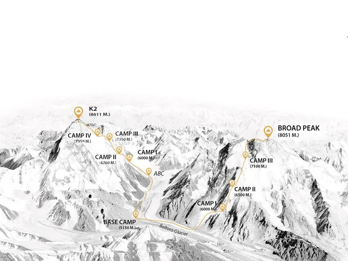
Recent Posts
Was this helpful?
🏔Related peaks nearby
🧭Explore & compare
Global Summit Guide is an independent mountaineering resource founded in 2026. The team combines first-hand trekking and climbing experience with in-depth research and professional health and nutrition review to help climbers choose objectives, prepare properly, and stay safe.
Health, altitude, and nutrition content is reviewed by Taylor Ludlow (Registered Nurse) and Brigg Hoopes (Nutritionist).
What We Don't Know Yet
Mountain information changes quickly. This box explains the limits of what this page can responsibly promise.
- Route conditions, trailhead access, crevasse exposure, stream crossings, and rescue access may vary from published planning guidance.
- Total trip cost can change with flights, lodging, guide pricing, permits, gear rentals, transportation, and exchange rates.
- Visa, passport, vaccination, border, insurance, and local transportation rules may change before your trip.
Verify current conditions with official land managers, guide services, local forecasts, and current route reports before booking or climbing.
Mountaineering, rock and ice climbing, glacier travel, and high-altitude activity are inherently dangerous and can result in serious injury or death. The information on Global Summit Guide is provided for general informational and educational purposes only and is not a substitute for professional instruction, qualified guiding, proper equipment, or your own judgment and experience.
Route conditions, weather, snowpack, permits, regulations, and hazards change constantly and may differ from what is described here. Details may be incomplete, out of date, or contain errors. Always verify current information with local authorities, certified guides, and official sources before making any decision in the mountains.
Nothing on this site is medical, legal, or financial advice. Our fitness, acclimatization, altitude, and nutrition content is general in nature; consult a qualified physician before beginning any strenuous exercise program or exposing yourself to high altitude.
You are solely responsible for your own safety and decisions. To the fullest extent permitted by law, Global Summit Guide and its team accept no liability for any loss, injury, damage, or expense arising from use of, or reliance on, this information. By using this site you acknowledge these risks and accept these terms.
Some links on this site may be affiliate links. If you buy through them we may earn a small commission at no extra cost to you; this never affects our recommendations.
Global Summit Guide recommendation path
Next Best Mountain to Research
Use these recommendations to continue the right planning path instead of stopping on one page.
Use current permit, weather, route, and operator information before booking or climbing.
Search Flights, Hotels & Rental Cars
Have the mountain or destination picked? Use Expedia to compare the flights, lodging and rental cars that fit your actual trip dates. For mountain travel, consider arriving early enough for delays and adding a buffer night after the climb before a fixed flight home.
Compare current flight, hotel and car options.
Affiliate disclosure: Global Summit Guide may earn a commission if you book through this link, at no additional cost to you.