
Last updated July 15, 2026

K2 Routes Explained: Abruzzi Spur, Cesen, North Ridge and Every Major Line
K2 has roughly a dozen documented routes and major variations, but almost every modern expedition is concentrated on two lines from Pakistan. This guide explains what each route climbs, where the principal camps and cruxes sit, and why “standard route” on K2 never means easy.
For almost every commercial climber, K2 means the Abruzzi Spur.
The Abruzzi Spur is the standard southeast-ridge route from Pakistan and carries most attempts. The Cesen Route is a steeper lower-mountain alternative that joins the Abruzzi high on the mountain. The North Ridge approaches from China and avoids the normal Bottleneck finish, but its access and support are far more difficult.
The remaining lines—Magic Line, Polish Line, West Ridge, Northeast Ridge and other face routes—belong to elite alpinism rather than normal expedition planning.
How this route guide fits the K2 content system
The parent guide, route guide and comparison page each have a separate job.
Find Hotels, Flights & Trips for the World’s Best Hiking Destinations
The Global Summit Guide Travel Shop on Expedia — curated for outdoor adventurers, mountaineers, and serious hikers. Patagonia to the Alps. Nepal to the Rockies. Curated lodging for every region we cover.
Explore Travel Shop on Expedia →Parent guide
The complete K2 climbing guide owns the broad mountain entity: routes, cost, weather, safety, permits and expedition planning.
This route guide
This page explains what each route climbs, its historical line, the major camps and the defining terrain.
Comparison page
The K2 route comparison owns side-by-side decision data and operator-use questions.
Best Season to Climb K2: Weather Windows & Safety Tips
Seven major lines define the mountain, but only two appear regularly in modern expedition plans.
| Route | Side | Modern use | Defining terrain | Normal expedition relevance |
|---|---|---|---|---|
| Abruzzi Spur | Pakistan · Southeast Ridge | Standard route | House’s Chimney, Black Pyramid, Shoulder, Bottleneck | Primary commercial line |
| Cesen Route | Pakistan · South-Southeast Spur | Occasional alternative | Steeper lower mixed terrain; joins Abruzzi high | Used selectively by some teams |
| North Ridge / North Pillar | China · North side | Very rare | Remote ridge and face climbing from the Shaksgam | Little commercial support |
| Magic Line | South-Southwest Pillar | Extreme | Sustained difficult rock, mixed and ice terrain | Elite alpine objective |
| Polish Line | South Face | Extreme | Direct, exposed south-face climbing | Historic elite line |
| West Ridge / West Face | West side | Very rare | Remote, steep mixed terrain | Specialized expedition only |
| Northeast Ridge | Northeast side | Rare | Complex ridge and upper-mountain linkups | Nonstandard alpine objective |
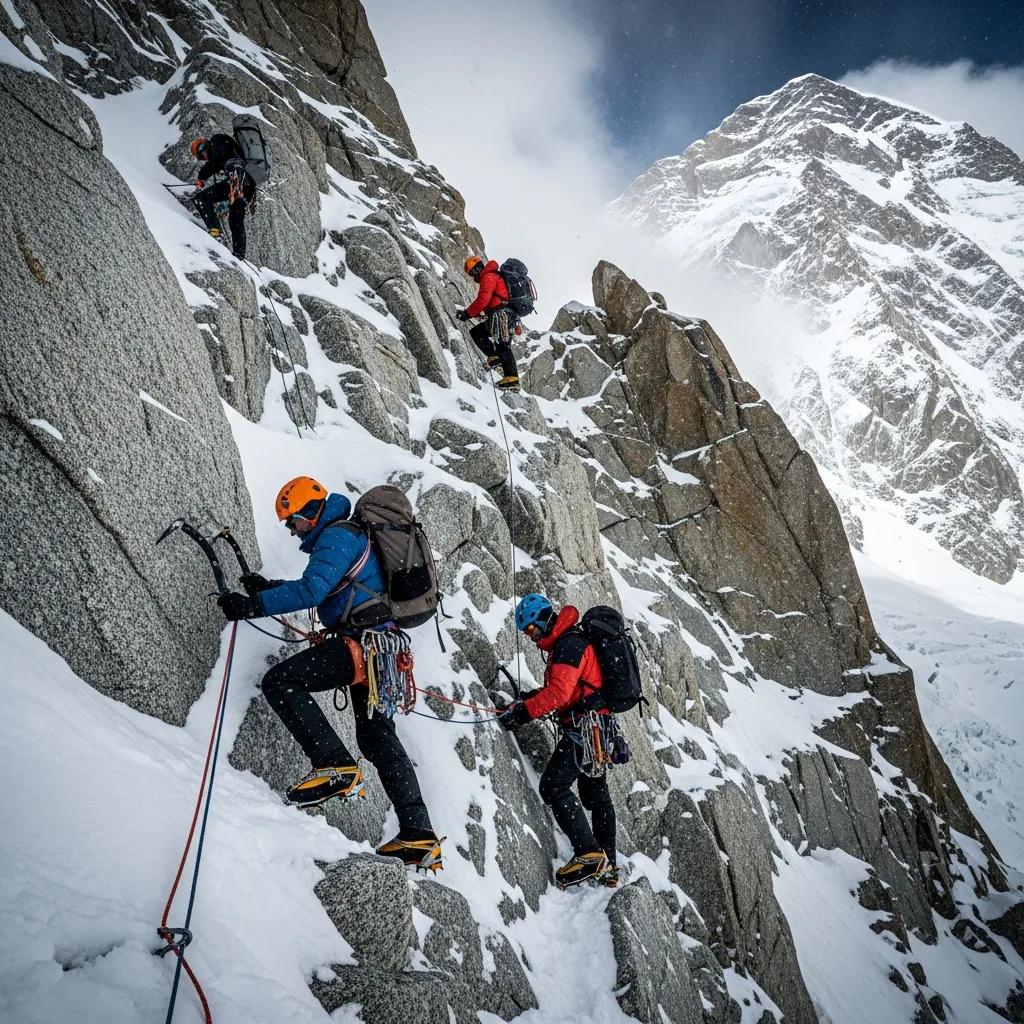
The Abruzzi Spur: K2’s standard route
The southeast ridge is the first-ascent line and the route used by most modern commercial expeditions.
Abruzzi Spur / Southeast Ridge
Pakistan side · Standard commercial route · First ascent line
- Base Camp: approximately 5,100–5,200 m on the Godwin-Austen Glacier.
- Camp 1: roughly 6,000–6,100 m above steep snow and mixed ground.
- House’s Chimney: steep rock and mixed climbing near the approach to Camp 2.
- Camp 2: commonly established around 6,600–6,700 m.
- Black Pyramid: sustained mixed terrain between Camps 2 and 3.
- Camp 3: around 7,200–7,400 m depending on conditions and team strategy.
- Shoulder / Camp 4: high camp near 7,800–8,000 m.
- Summit crux: the Bottleneck and traverse beneath the hanging serac.
The Abruzzi Spur is called the normal route because it has the most established camp pattern, the largest concentration of operators and the most predictable seasonal rope-fixing effort. Those advantages are logistical, not technical. The line remains steep, exposed and hazardous from the lower ridge to the summit.
House’s Chimney
This steep rock feature sits near the route to Camp 2 and is named for American climber Bill House, who climbed it during the 1938 expedition. Fixed lines can make upward movement more efficient, but climbers still need the strength and technique to ascend, pass others and descend while wearing altitude equipment.
The Black Pyramid
The Black Pyramid is the technical heart of the lower Abruzzi. It combines rock, ice and mixed climbing across a long band between Camps 2 and 3. Conditions can change the exact difficulty dramatically. Thin snow may expose harder rock; heavy loading can increase avalanche and spindrift risk.
The Shoulder
The route temporarily eases onto the broad Shoulder before high camp. The apparent relief is deceptive. Climbers arrive severely hypoxic, summit-day timing becomes critical and the most objective-dangerous terrain still lies above.
The Cesen Route: a steeper lower-mountain alternative
The Cesen climbs a more direct south-southeast line before joining the Abruzzi high on K2.
Cesen Route / Basque Route
Pakistan side · South-Southeast Spur · Joins the Abruzzi high on the mountain
- More direct and more sustained on the lower mountain.
- Avoids House’s Chimney and portions of the Black Pyramid.
- May reduce some lower-route rockfall exposure in favorable conditions.
- Often has less extensive or less continuously maintained fixed rope.
- Joins the Abruzzi before the summit finish.
- Still requires the Bottleneck and traverse on the standard upper line.
The Cesen is not an easier version of K2. It trades one collection of hazards for another. Its lower line is steeper, more sustained and more dependent on competent movement over snow, ice and mixed terrain. It can be attractive when the Abruzzi’s lower rockfall or crowding is especially problematic, but the decision normally belongs to experienced expedition leadership rather than individual client preference.
The North Ridge and North Pillar from China
The north side offers a different mountain experience, but access and support are the central obstacles.
North Ridge / North Pillar
Xinjiang, China · Shaksgam approach · Very limited modern traffic
- First climbed by a Japanese expedition in 1982.
- Approached through the remote Shaksgam Valley.
- Requires complex access and permit logistics.
- Has far less operator, rope-fixing and rescue infrastructure.
- Uses a different upper-mountain line and does not depend on the normal Bottleneck passage.
The north side is sometimes described as an alternative that avoids the Bottleneck, which is true in route geometry but incomplete as a decision. The Shaksgam approach, border administration, river conditions, distance and lack of support create a completely different expedition problem. A line can avoid one famous hazard while becoming less feasible overall.
The extreme lines: Magic Line, Polish Line and other faces
These are historical and elite alpine objectives—not alternatives for a conventional K2 expedition.
Magic Line
The South-Southwest Pillar is one of the mountain’s most famous hard routes. It combines sustained technical climbing, difficult retreat and extreme exposure at altitude.
Polish Line
The direct South Face line climbed in 1986 is remembered as one of the boldest routes in 8,000-meter history. Its seriousness extends well beyond ordinary expedition grades.
West Ridge and West Face
These remote western lines have seen very little traffic and require highly self-sufficient alpine teams.
Northeast Ridge
The northeast side includes complex line combinations and route-finding problems that have attracted only occasional expeditions.
These routes matter because they explain K2’s full geography and history. They do not belong on a “which commercial route should I choose?” shortlist. Climbers considering them already possess the expedition résumé, technical partnership and independent decision-making required to research them far beyond a general guide.
The Bottleneck: the shared crux of the normal upper route
A steep couloir and traverse beneath a hanging serac define summit day on the Abruzzi and Cesen lines.
The Bottleneck begins around 8,200 m. Climbers ascend a steep couloir, then make a rising traverse beneath a massive hanging ice feature. The location combines extreme altitude, narrow terrain, congestion, fixed-line dependence and objective serac hazard.
The most important fact is that skill cannot eliminate the serac. Better timing, stronger movement and disciplined turnaround decisions can reduce exposure, but they cannot control hanging ice. That distinction makes the Bottleneck different from a purely technical crux.
Standard Abruzzi camp progression
Exact elevations move with conditions, but the four-camp structure remains the normal expedition framework.
| Stage | Approximate elevation | Terrain and purpose | Main concern |
|---|---|---|---|
| Base Camp | 5,100–5,200 m | Expedition base on the Godwin-Austen Glacier | Acclimatization, weather waiting and logistics |
| Camp 1 | 6,000–6,100 m | Lower ridge above glacier approach | Rockfall, steep snow and early altitude response |
| Camp 2 | 6,600–6,700 m | Near House’s Chimney and mixed terrain | Crowding, exposure and technical efficiency |
| Camp 3 | 7,200–7,400 m | Above or near the Black Pyramid | Wind, avalanche exposure and recovery failure |
| Camp 4 | 7,800–8,000 m | The Shoulder and summit launch point | Short rest, oxygen management and timing |
| Summit | 8,611 m | Bottleneck, traverse and upper snow slopes | Serac exposure, congestion, descent and weather |
How climbers actually choose a K2 route
For most teams, route choice is less personal than it first appears.
Commercial operators typically organize around the Abruzzi because it has the strongest logistics, the most predictable rope-fixing coordination and the greatest shared infrastructure. A Cesen decision may be made when lower-mountain conditions favor the alternative. The North Ridge is a separate expedition model rather than a normal second choice.
Choose the operator first
Evaluate leadership, rope-fixing participation, oxygen plan, high-altitude staffing, weather support and turnaround discipline before focusing on a route label.
Let conditions influence the line
Snow loading, rockfall and team coordination can make one lower route more sensible in a given season.
Use the K2 operators guide for company research and the K2 route comparison for the detailed decision matrix.
Plan the Pakistan travel component
Use the Global Summit Guide Expedia shop to compare international flights and staging travel. K2 expedition ground logistics beyond Islamabad and Skardu should be coordinated with the expedition operator.
Affiliate disclosure: Global Summit Guide may earn a commission when you book through this link, at no additional cost to you.
Shop K2 Expedition Travel on ExpediaRequired experience before any K2 route
K2 is not the mountain on which to acquire basic high-altitude or technical skills.
- Prior successful 7,000-meter and preferably 8,000-meter expedition experience
- Confident crampon movement on steep ice and mixed terrain
- Independent fixed-line ascent and descent
- Rappelling with gloves, oxygen equipment and a heavy pack
- Crevasse rescue and glacier-travel competence
- Ability to climb through the night at extreme altitude
- Strong judgment under fatigue and hypoxia
- Documented willingness to turn around below the summit
- Cold-injury prevention and self-monitoring
- Experience living and recovering through a long expedition cycle
The dedicated K2 training plan, K2 gear list and K2 weather guide cover those preparation systems in detail.
Common route-planning failure patterns
Teams often fail because they misunderstand the route system rather than because they choose the wrong named line.
Confusing “standard” with moderate
The Abruzzi is standard only because it is the most frequently climbed route. It remains a serious technical line at extreme altitude.
Treating fixed ropes as guaranteed
Rope fixing can be late, incomplete or damaged. Climbers still need independent systems competence.
Assuming the Cesen avoids the upper hazard
The Cesen joins the Abruzzi and shares the Bottleneck summit finish.
Planning summit day but not descent
The route remains technical after the summit, when fatigue and weather risk are often greatest.
K2 routes FAQ
Direct answers to the most common route questions.
What is the standard route on K2?
The Abruzzi Spur, or Southeast Ridge, is the standard route and the line used by most commercial expeditions.
How many routes does K2 have?
Roughly a dozen documented routes and major variations exist, but only the Abruzzi and Cesen see regular modern traffic.
Is the Cesen Route easier?
No. It is steeper and more sustained low on the mountain, may have less fixed-rope support and still joins the Abruzzi for the Bottleneck finish.
Can K2 be climbed from China?
Yes, via the north side, but the remote Shaksgam approach, access rules and lack of support make it a very rare expedition.
What is the hardest part of the Abruzzi?
House’s Chimney and the Black Pyramid are major lower technical sections. The Bottleneck is the defining high-altitude objective-hazard section.
Which route should a first-time K2 climber choose?
A climber qualified for K2 will normally join an operator using the Abruzzi Spur. The expedition leader may consider the Cesen based on seasonal conditions.
Research and uncertainty
Global Summit Guide has not climbed K2. This page synthesizes the site’s existing K2 research, historical route descriptions and expedition reporting. Exact grades, camp elevations, route joins and traffic percentages vary by source and season. Current operators and expedition leaders remain the final authority for the active route.
Continue with the complete K2 plan
Use the parent guide for permits, weather, costs, safety and expedition planning, then use the comparison page when evaluating Abruzzi, Cesen and north-side differences.
Open the Complete K2 Guide Compare K2 RoutesThere’s more than one way up the Savage Mountain. See every major line explained — from the standard Abruzzi Spur to the rarely-climbed North Ridge — in the full guide to K2 routes.
Was this helpful?
🏔Related peaks nearby
🧭Explore & compare
Global Summit Guide is an independent mountaineering resource founded in 2026. The team combines first-hand trekking and climbing experience with in-depth research and professional health and nutrition review to help climbers choose objectives, prepare properly, and stay safe.
Health, altitude, and nutrition content is reviewed by Taylor Ludlow (Registered Nurse) and Brigg Hoopes (Nutritionist).
What We Don't Know Yet
Mountain information changes quickly. This box explains the limits of what this page can responsibly promise.
- Route conditions, trailhead access, crevasse exposure, stream crossings, and rescue access may vary from published planning guidance.
- Visa, passport, vaccination, border, insurance, and local transportation rules may change before your trip.
- Route conditions, snowpack, closures, and weather can change quickly after this page is updated.
- Permit rules, fees, quotas, and reservation windows may change between review cycles.
- Operator availability, pricing, guide ratios, and cancellation terms can change by season.
Verify current conditions with official land managers, guide services, local forecasts, and current route reports before booking or climbing.
Part of this Global Summit Guide cluster
Explore the complete K2 guide for more context, routes, planning links, and related resources.
Mountaineering, rock and ice climbing, glacier travel, and high-altitude activity are inherently dangerous and can result in serious injury or death. The information on Global Summit Guide is provided for general informational and educational purposes only and is not a substitute for professional instruction, qualified guiding, proper equipment, or your own judgment and experience.
Route conditions, weather, snowpack, permits, regulations, and hazards change constantly and may differ from what is described here. Details may be incomplete, out of date, or contain errors. Always verify current information with local authorities, certified guides, and official sources before making any decision in the mountains.
Nothing on this site is medical, legal, or financial advice. Our fitness, acclimatization, altitude, and nutrition content is general in nature; consult a qualified physician before beginning any strenuous exercise program or exposing yourself to high altitude.
You are solely responsible for your own safety and decisions. To the fullest extent permitted by law, Global Summit Guide and its team accept no liability for any loss, injury, damage, or expense arising from use of, or reliance on, this information. By using this site you acknowledge these risks and accept these terms.
Some links on this site may be affiliate links. If you buy through them we may earn a small commission at no extra cost to you; this never affects our recommendations.
Global Summit Guide recommendation path
Next Best Mountain to Research
Use these recommendations to continue the right planning path instead of stopping on one page.
Use current permit, weather, route, and operator information before booking or climbing.