
Unforgettable Views Await on Your Mount Fuji Climb
The scenic guide to Japan’s sacred peak — Chureito Pagoda’s iconic view, the Five Lakes, the goraiko sunrise, the sea of clouds phenomenon, and the visual moments that have inspired 1,400 years of Japanese art.
elevation
Five Lakes
Chureito
visibility
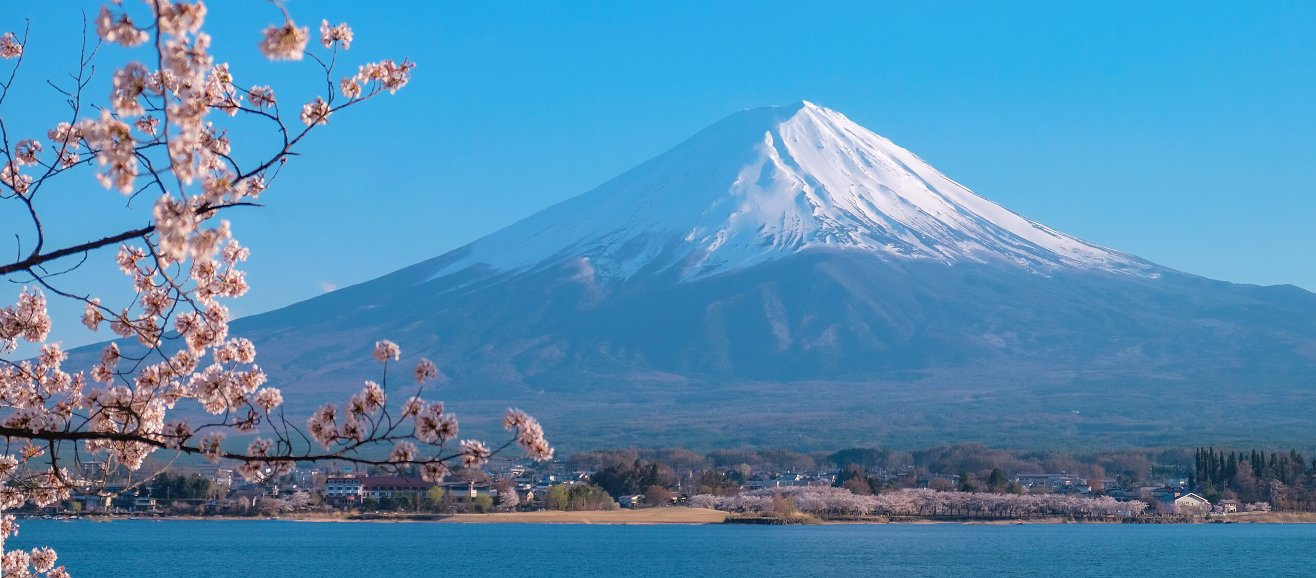
Mount Fuji is not just a mountain — it is a visual icon that has shaped Japanese art, literature, and spirituality for centuries. From Hokusai’s legendary woodblock prints to modern Instagram posts, Fuji’s near-perfect volcanic cone has become one of the world’s most recognizable images. This guide covers what you’ll actually see on and around Fuji — the iconic Chureito Pagoda vantage, the five lakes that mirror the mountain, the goraiko sunrise from the summit, the spectacular sea of clouds phenomenon, and the five ecological zones you’ll traverse during the climb. Whether you’re climbing to the top or photographing from a distance, this is the scenic companion to our operational Mount Fuji climbing guide.
Viewpoint data verified against Yamanashi Prefecture Tourism materials and Japan National Tourism Organization recommendations. Photography timing confirmed through Japan Meteorological Agency sunrise/sunset tables for Fuji’s coordinates. Cultural context draws from UNESCO World Heritage designation materials and Hokusai catalogue research. Ecological zones referenced against Japanese Ministry of the Environment classifications. Reviewed by Japanese photography guides and Fuji Five Lakes tourism authorities. Fact-check date: April 19, 2026.
The Most Iconic Fuji View: Chureito Pagoda
忠霊塔 · Chureito PagodaThe five-story red pagoda that frames Mount Fuji
If you’ve seen one image of Japan, it’s probably this one. Chureito Pagoda sits on a hillside in Arakurayama Sengen Park, a five-story vermilion tower built in 1963 as a war memorial. From a viewing platform 398 stone steps above the park entrance, the pagoda frames Mount Fuji in what has become the most photographed view in Japan. Cherry blossoms frame the scene in April. Golden light transforms it at sunrise. It’s featured on travel posters, magazine covers, and countless photos — but seeing it in person still exceeds expectations.
The Fuji Five Lakes: Five Perspectives on One Mountain
Clustered at Fuji’s northern base, the Fuji Five Lakes (Fujigoko, 富士五湖) are volcanic lakes each offering a distinct perspective on the mountain. Together they form the premier Fuji-viewing region — and the Lake Kawaguchi area is the most accessible from Tokyo.
Most accessible. Home to sakasa-Fuji reflection view and Oishi Park lavender.
Largest lake, closest to Fuji, best sunset photography.
Quieter, traditional village atmosphere, fishing focus.
Smallest lake, “Mother and Child” double-Fuji illusion.
¥1,000 banknote view, deepest at 121m, less-developed.
Lake Kawaguchi (河口湖)
Lake Kawaguchi is the Fuji Five Lakes’ most visited destination. Direct train connection from Tokyo Shinjuku via Kawaguchiko makes it achievable as a day trip. The north shore offers the famous sakasa-Fuji (逆さ富士) — upside-down Fuji — when the lake reflects the mountain’s perfect image on calm mornings. Oishi Park on the north shore features lavender fields blooming June-July with Fuji backdrop. Kawaguchiko Music Forest and other museums provide cultural experiences.
Best photography spots on the lake: (1) Nakaba Park north shore for sakasa-Fuji mirror shots at sunrise. (2) Oishi Park lavender fields during June-July bloom with Fuji behind. (3) Kawaguchiko Tenjoyama Park Ropeway for elevated lake-and-Fuji panorama. (4) Northern rocky shorelines for foreground-interest compositions.
Lake Yamanaka (山中湖)
Lake Yamanaka is the largest and highest of the Fuji Five Lakes at 980m elevation. Its proximity to Fuji (8km distant) means the mountain dominates the horizon view. Popular with watersports enthusiasts (swan boats, paddleboarding, sailing) and photographers. Evening light on Fuji from Yamanaka is particularly dramatic — the mountain often catches last sunlight after surrounding valleys have fallen into shadow.
Accessible from Tokyo via bus from Shinjuku or train to Fujisan Station then local bus. The north shore offers best sunset photography positions. Swan boat rides on Yamanaka are a quintessential summer Japan experience.
Lake Motosu (本栖湖)
Lake Motosu features on Japan’s ¥1,000 banknote — the view from the lake showing Mount Fuji rising above cherry blossoms was photographed by Okada Koyo in 1935 and has been the currency design element since 2004. The lake is a volcanic crater with depths to 121m, Japan’s 9th deepest. Less developed than Kawaguchi, with camping and nature focus.
Best photo position: Southwestern shore near the banknote viewpoint marker. Access via car is easiest; bus routes limited but available from Kawaguchiko. Capture the banknote view with cherry blossom framing for the quintessential Japanese currency image.
From the Summit: What 3,776 Meters Reveals
Climbing to Uhuru Peak of Mount Fuji rewards you with views unmatched anywhere else in Japan. The summit offers 360-degree panoramas extending up to 200 kilometers on exceptionally clear days.
Goraiko (御来光) Sunrise
The Japanese word goraiko means “the arrival of light” — the name given to sunrise viewed from Mount Fuji’s summit. For over 1,400 years, Japanese pilgrims have climbed Fuji specifically to witness dawn from the peak. Under 2026 regulations requiring mountain hut stays, goraiko is a mandatory overnight experience — you cannot bullet-climb through the night for sunrise anymore.
The moment: stars begin to fade around 04:15 AM, followed by deep blue sky colors. Golden light breaks across the eastern horizon at approximately 04:30-05:00 AM depending on date. The first direct sunlight hits Fuji’s summit as it rises above the Pacific Ocean horizon. Climbers at 3,776m stand above essentially all of Japan’s geography. Clear summit sunrise occurs in approximately 30-40% of climb attempts — clouds frequently obscure views even after perfect weather forecasts.
Ohachimeguri (お鉢巡り) Crater Walk
The summit of Fuji is actually the rim of a 500-meter-wide, 250-meter-deep volcanic crater (Ohachi). The crater rim walk — called Ohachimeguri — circles the entire summit, passing eight named peaks over approximately 60-90 minutes. True summit is at Kengamine Peak (3,776m). Each peak around the rim has religious significance, with shrines, stone markers, and pilgrim offerings.
What you’ll see on the walk: (1) Dramatic views down into the dormant crater (last eruption 1707). (2) Small year-round snowfields on north-facing slopes. (3) Kusushi Jinja — summit shrine of Sengen Taisha at 3,715m. (4) Traditional weather station ruins at Kengamine (closed 2004). (5) Centuries of pilgrimage artifacts. (6) Most spectacular 360-degree views available anywhere in Japan.
Unkai (雲海) Sea of Clouds
The sea of clouds (unkai) is a spectacular phenomenon where clouds form a layer below Fuji’s summit elevation, creating the visual illusion of Fuji as an island rising from a white ocean. Formed by temperature inversions — warm air trapping cooler moisture below — clouds stabilize at 2,000-3,000m, leaving summit climbers literally above the clouds.
Occurrence rate: approximately 40-60% of summit visits encounter some form of cloud layer below; full horizon-to-horizon sea of clouds occurs in about 20-30% of visits. Most dramatic at sunrise when low-angle sunlight paints the cloud surface golden. When present, the sea of clouds transforms the summit experience from a mountain view into an otherworldly perspective.
The Shadow of Fuji
At sunrise from the summit, Fuji casts its distinctive perfect pyramid-shaped shadow westward onto the atmosphere and any cloud layer below. The shadow appears as a dark triangle stretching dozens of kilometers from the mountain, bordered by warm morning light. Lasts approximately 15-20 minutes after sunrise before the sun rises high enough to dissolve the effect.
Photographically: wide-angle lenses capture the full shadow extent. Long exposures blur any cloud movement for dreamy effect. The shadow is visible from Fuji’s eastern rim peaks, making early summit arrival on the east side essential for capturing this phenomenon. Many climbers miss the shadow because they’re focused on the sunrise itself — turn around and look west.
The Five Ecosystem Zones: Five Worlds in One Climb
Climbing Mount Fuji traverses five distinct ecological zones — from deciduous forests at the base to alpine desert at the summit. The transitions create one of Japan’s most dramatic vegetational progressions compressed into a single day’s climb.
Mount Fuji’s Five Ecological Zones
- Deciduous forest (800-1,600m): Oak, maple, beech forests. Spectacular autumn colors October-November. Typically driven through on Fuji Subaru Line rather than walked.
- Temperate mixed forest (1,600-2,000m): Larch, birch, rhododendron mix. Wildflower blooms June-July. Subashiri Trail 5th Station (2,000m) begins here.
- Subalpine coniferous (2,000-2,500m): Dense pine and fir. Yoshida 5th Station (2,305m) in this zone. Temperatures noticeably cooler.
- Alpine scrub (2,500-3,200m): Stunted pine, shrubs, volcanic rock dominating. Most trail sections pass through here. Mountain huts cluster in this band.
- Alpine desert (3,200-3,776m): Barren volcanic landscape, scattered lichen, dramatic red-black rock and scree. Upper huts and summit approach. Moonscape aesthetic.
The ecological transition is most noticeable on Subashiri Trail, which begins in forest and emerges dramatically above the tree line. On Yoshida Trail, climbers skip the lower forest zones via the bus to 2,305m 5th Station.
Seasonal Fuji Views: Year-Round Different Faces
Mount Fuji presents different aesthetics through each of Japan’s four seasons. While climbing is restricted to summer, photography opportunities exist year-round from distant viewpoints.
Spring
Cherry blossom season. Fuji framed by sakura creates iconic image. Chureito Pagoda peak photography. Still snow-capped for dramatic contrast.
Summer
Climbing season. Mountain huts open, trails accessible. Summit views possible. Atmospheric haze can reduce distant visibility. Lavender blooms at Oishi Park June-July.
Autumn
Fall colors. Japanese maple foreground with Fuji creates classic landscape. Clearer air than summer. Fewer crowds at viewpoints. First snow typically dusts peak.
Winter
Snow-capped classic. Clearest atmospheric conditions of year. Sharpest views from distant Tokyo. Mountain climbing closed but photography optimal.
Peak cherry blossom timing varies 5-10 days year-to-year but typically runs late March to mid April in the Fuji region. Target destinations: (1) Chureito Pagoda — the iconic image. (2) Lake Kawaguchi Oishi Park shoreline. (3) Arakura Fuji Sengen Shrine grounds. (4) Oishi Park on Lake Kawaguchi’s north shore. Peak bloom lasts only 7-10 days — monitor Japan Weather Association’s sakura forecast (sakura.weathermap.jp) starting mid-February. Weekends during peak bloom see extreme crowds at all major viewpoints. Weekday early-morning visits are essential for photography.
Distant Fuji Viewpoints: From Tokyo to Yokohama
For travelers who don’t climb or visit the Fuji Five Lakes directly, Mount Fuji can still be photographed from the greater Tokyo region on clear days.
Tokyo Skytree & Observatory Decks
Tokyo Skytree (634m), Tokyo Tower (333m), Roppongi Hills Observatory (270m), and Shinjuku’s Tokyo Metropolitan Government Building (202m) all provide Fuji views on clear days. Annual visibility approximately 30% — best December through February, worst June through August. Early morning before urban pollution builds offers best odds.
Hakone Lake Ashi
Hakone offers traditional ryokan stays with Fuji views across Lake Ashi. The red torii gate of Hakone Shrine standing in the lake with Fuji rising behind is another iconic Japan image. Accessible from Tokyo in 90 minutes via Odakyu Romance Car. Combine with onsen (hot spring) bathing for quintessential Japanese travel experience.
Mishima Skywalk
The Mishima Skywalk is Japan’s longest suspension pedestrian bridge at 400 meters. Offers spectacular panoramic Fuji views from the bridge deck on clear days. Combines Fuji viewing with engineering marvel experience. Access from Tokyo via Tokaido Shinkansen to Mishima Station in 45 minutes, then local bus.
Shinkansen Window Views
The Tokaido Shinkansen (bullet train) between Tokyo and Osaka passes through Shizuoka with spectacular Fuji views from the right-side (northern) windows heading Tokyo-to-Osaka. Best seats: E-side window seats for Tokyo-bound, D-side for Osaka-bound. Fuji is visible for approximately 5-10 minutes as the train passes Shin-Fuji Station area. Cameras ready — the view appears suddenly. Perfect for travelers who pass through without dedicated Fuji visits.
Photography Tips for Mount Fuji
Whether climbing or viewing from distance, these technical and timing approaches yield the best Fuji images:
- Golden hour dominates: Best light occurs 30 minutes before and after sunrise/sunset. Midday lighting is harsh and flattens the mountain’s volumetric form.
- Weather forecasting: Check live webcams at multiple viewpoints 2-3 days ahead. Japan Weather Association (tenki.jp) provides dedicated Fuji visibility forecasts.
- Clear days are gold: Fuji is visible from Tokyo only about 30% of days annually. From closer viewpoints, visibility rises to 50-70%. December-February has best visibility; June-August has worst.
- Tripod essential: Low-light photography at Chureito Pagoda, lakes at sunrise/sunset, and summit dawn all require stabilization. Carbon fiber travel tripod recommended.
- Lens selection: Wide angle (16-35mm) for scene-setting with foreground interest. Standard zoom (24-70mm) for versatility. Telephoto (70-300mm) for compressing perspective and isolating Fuji against distant backgrounds.
- Foreground matters: Mount Fuji itself is iconic but photos benefit from foreground interest — cherry blossoms, torii gates, reflective lakes, shoreline rocks, lavender fields.
- Reflections are rare: Sakasa-Fuji (upside-down Fuji reflections) only occurs on calm mornings with minimal wind. Target dawn visits at Lake Kawaguchi or Yamanaka’s calmer areas.
- Be prepared for crowds: All major viewpoints fill during cherry blossom season and peak weekends. Arrive hours early, weekdays preferred, sunrise shots require pre-dawn positioning.
Mount Fuji Views FAQ: Your Common Questions Answered
What is the best viewpoint of Mount Fuji?
The most iconic view of Mount Fuji is from Chureito Pagoda (忠霊塔) in Arakurayama Sengen Park — the five-story red pagoda with Mount Fuji rising behind it has become one of Japan’s most photographed scenes. Additional top Mount Fuji viewpoints: (1) Lake Kawaguchi north shore — the reflective ‘sakasa-Fuji’ (upside-down Fuji) phenomenon on calm mornings creates the postcard-perfect mirror image. Best at sunrise. (2) Lake Yamanaka — Fuji’s closest lake view, best for sunset photography with mountain reflection. (3) Lake Motosu — featured on the ¥1,000 banknote; less developed, more solitude. (4) Oishi Park on Kawaguchi’s north shore — lavender fields in summer with Fuji backdrop. (5) Mishima Skywalk — Japan’s longest suspension bridge with Fuji panorama. (6) Hakone area — traditional onsen town with classic Fuji views across Lake Ashi. (7) The summit itself — 360-degree panoramic views including sea of clouds, crater, surrounding peaks. (8) Shinkansen train passing through Shizuoka — moving Fuji views from the bullet train window. Chureito Pagoda specifically captures the platonic ideal of Japan: ancient pagoda, cherry blossoms (April), and Fuji. Visit at sunrise for golden light, or during cherry blossom season (late March to mid-April) for the iconic shot featured in countless travel magazines and Hokusai’s famous woodblock prints.
When is the best time to photograph Mount Fuji?
The best times to photograph Mount Fuji depend on your desired aesthetic, but clear weather is the universal requirement. Seasonal photography guide: (1) Winter (December-February) — Snow-capped Fuji is the classic image. Coldest, clearest air of the year, sharpest views from distant vantage points. Best visibility month is December. (2) Spring (late March-April) — Cherry blossom (sakura) season with Fuji backdrop creates iconic images. Chureito Pagoda at sunrise during peak bloom is the most-photographed scene in Japan. Bloom timing varies 5-10 days yearly. (3) Summer (June-August) — Climbing season reveals Fuji close-up. Atmospheric haze often reduces distant views but goraiko sunrise from summit is extraordinary. Clear summit views occur approximately 30-40% of attempts. (4) Autumn (October-November) — Fall colors with Fuji backdrop, similar visibility to winter, cooler temperatures without snow yet. Daily timing matters: (5) Early morning (5:00-7:00 AM) — Clearest atmospheric conditions, golden hour lighting, lowest haze. Most photographed Fuji images are from dawn. (6) Blue hour (just before sunrise) — Deep blue sky contrasts dramatically with snow-capped peak. (7) Late afternoon (3:00-5:00 PM) — Good lighting, lower crowds at viewpoints. (8) Night photography — Star trails and Milky Way behind Fuji silhouette. Weather forecasting: Check live cams at multiple viewpoints days ahead. Fuji is visible from Tokyo approximately 30% of days annually; from closer viewpoints 50-70% depending on season.
What can you see from Mount Fuji summit?
The summit of Mount Fuji offers extraordinary 360-degree views extending up to 200km on exceptionally clear days. Visible features from the summit: (1) Fuji’s crater (Ohachi) — the extinct volcanic crater is 500m wide and 250m deep, walking the crater rim (Ohachimeguri) takes approximately 60-90 minutes. Eight named peaks around the rim, with Kengamine at 3,776m being the true highest point. (2) Sea of Clouds (Unkai) — When low clouds form below summit elevation, Fuji rises as an island above them. Occurs in approximately 40-60% of summit visits depending on weather. Spectacular photography opportunity. (3) Shadow of Fuji — At sunrise, Fuji casts its distinctive pyramid-shaped shadow westward onto lower clouds. Lasts 15-20 minutes after sunrise. (4) Distant landmarks — Mount Kita (3,193m, Japan’s second-highest) visible to northwest; Pacific Ocean visible to south; Tokyo skyline faintly visible to northeast on clearest days; Izu Peninsula visible to south. (5) Surrounding peaks — Japanese Alps stretch north, including Mount Yatsugatake, Mount Kita, Mount Aino, and Mount Warusawa. (6) Five Lakes — Lakes Kawaguchi, Yamanaka, Saiko, Shoji, and Motosu visible to north. (7) Glacier remnants — Small permanent snowfields year-round on north-facing slopes. (8) Summit shrines — Kusushi Jinja (inner shrine of Sengen Taisha), traditional Japanese architecture at 3,715m elevation. (9) Weather station — Abandoned observatory at Kengamine Peak, closed 2004 but structures remain. (10) Pilgrimage markers — Stone lanterns, prayer stakes, coin offering boxes from centuries of spiritual climbs. Summit visits average 30-60 minutes for most climbers — longer for those doing crater rim walk.
What are the Fuji Five Lakes?
The Fuji Five Lakes (Fujigoko, 富士五湖) are a chain of volcanic lakes formed at Mount Fuji’s northern base, each offering distinct Fuji views and experiences. The five lakes in detail: (1) Lake Kawaguchi (河口湖) — Most developed and accessible, connected to Tokyo by direct rail (Fujikyu Railway). Home to Oishi Park (lavender fields), Kawaguchiko Music Forest, and the reflective ‘sakasa-Fuji’ north shore. 5.2 km² surface area. Best lake for first-time visitors. (2) Lake Yamanaka (山中湖) — Largest lake (6.8 km²), closest to Fuji, highest elevation at 980m. Popular for watersports and sunrise photography. Swan boat tours popular. (3) Lake Saiko (西湖) — Known for fishing and the Saiko Iyashi-no-Sato Nenba traditional village reconstructed to look like pre-modern Japan. Quieter, less touristy. (4) Lake Shoji (精進湖) — Smallest lake (0.5 km²), rural character, the famous ‘Mother and Child Fuji’ view where a smaller hill appears in front of Fuji creating the illusion of two mountains. (5) Lake Motosu (本栖湖) — Deepest lake (121m), featured on the ¥1,000 banknote view of Fuji with cherry blossoms. Crater lake character, popular for camping and less-developed scenery. Best Fuji Five Lakes experiences: (a) Rent a car and do a full-day loop around all five lakes. (b) Stay overnight at a ryokan (traditional inn) in Kawaguchiko. (c) Take a boat tour on Lake Kawaguchi. (d) Visit Chureito Pagoda from Kawaguchiko for iconic photo. (e) Cherry blossom viewing in April around Lake Kawaguchi’s Oishi Park. Access: Direct train from Tokyo Shinjuku to Kawaguchiko in 2 hours; local bus network connects all five lakes.
Is Chureito Pagoda worth visiting?
Yes, Chureito Pagoda (忠霊塔) is absolutely worth visiting — it’s arguably the most iconic viewpoint for photographing Mount Fuji in Japan. Chureito Pagoda essentials: (1) Location: Arakurayama Sengen Park, Fujiyoshida city, on a hillside north of Lake Kawaguchi. About 15-minute walk uphill from Shimoyoshida Station. (2) The climb: 398 stone steps from park entrance to pagoda viewing platform. Moderately steep but achievable for most visitors. (3) The iconic view: Five-story red pagoda (built 1963 as a war memorial) with Mount Fuji rising behind it. Cherry blossoms frame the scene during peak bloom. Appears in countless Japan travel posters, Instagram posts, magazine covers. (4) Best visiting times: (a) Cherry blossom season — late March to mid-April. Approximately 650 cherry trees bloom around the pagoda. Peak bloom varies 5-10 days yearly. (b) Sunrise — Pagoda receives warm golden light from 05:30-06:30 AM. Fuji visibility best in early morning. (c) Autumn — October-November has cooler weather and fall color contrast with red pagoda. (5) Crowds reality: The pagoda gets extremely crowded during cherry blossom season — expect hundreds of photographers at sunrise. Arrive 2+ hours before planned shot to secure position on the platform. Weekdays much less crowded than weekends. (6) Photography tips: Telephoto lens (200-400mm) compresses pagoda and Fuji perspective. Wide angle captures full scene. Tripod essential for low-light shots. Access: Train to Shimoyoshida Station on the Fujikyu Line from Tokyo (2.5 hours from Shinjuku via Kawaguchiko). Free entry to the park. Climb takes 20-30 minutes. Visit 1-2 hours for photography. Combine with Kawaguchiko visit on same day.
What is the sea of clouds on Mount Fuji?
The sea of clouds (unkai, 雲海) is a spectacular meteorological phenomenon where a layer of clouds forms below Mount Fuji’s summit elevation, creating the illusion of a cloud ocean with Fuji rising as an island above it. Sea of clouds science: (1) Formation conditions — Temperature inversion creates a stable cloud layer typically at 2,000-3,000m elevation. Warm air above cooler moisture layer causes clouds to form just below summit elevation. (2) Best weather patterns — Clear cold nights followed by warming mornings; high pressure systems; early summer to early autumn. (3) Frequency — Approximately 40-60% of summit visits encounter some form of cloud layer below. Full sea of clouds stretching to horizon: 20-30% of summit visits. (4) Timing — Most common at sunrise (04:30-06:00 AM) as temperature differentials peak. Dissipates mid-morning as clouds lift or dissolve. Viewing experiences: (1) From Fuji summit — Clouds stretch to horizon 360 degrees. Fuji’s shadow visible at sunrise projecting westward across cloud surface. (2) From high camp huts — 7th and 8th Station huts at 2,700-3,400m often positioned just above cloud layer for spectacular dawn views. (3) From airplane — Commercial flights passing near Fuji sometimes photograph sea of clouds from cruise altitude. (4) From distant peaks — Adjacent mountains like Mount Kita or Japanese Alps peaks offer views of Fuji rising from clouds. Photography considerations: (5) Golden hour light creates warm-colored cloud surface; blue hour creates cool-toned drama. (6) Long lens compresses Fuji and cloud layer. (7) Wide angle captures full horizon panorama. Not guaranteed: The phenomenon cannot be predicted precisely — it requires multiple climbs to reliably experience. Many climbers encounter sea of clouds by luck; dedicated photographers may make multiple attempts.
What ecosystems do you pass climbing Mount Fuji?
Climbing Mount Fuji traverses five distinct ecological zones, creating one of Japan’s most dramatic vegetational transitions in a single day. The five zones from base to summit: (1) Deciduous forest (800-1,600m) — Oak, maple, beech forests at lower elevations. Autumn colors spectacular October-November. Typically passed by car on Fuji Subaru Line; not walked in most climbs. (2) Temperate mixed forest (1,600-2,000m) — Coniferous and deciduous mix, larch, birch, rhododendron. Some 5th Stations begin here (Subashiri at 2,000m starts in this zone). Wildflowers bloom June-July. (3) Subalpine coniferous forest (2,000-2,500m) — Dense pine and fir forests, temperatures noticeably cooler, mountain hares and small birds common. Yoshida Trail 5th Station (2,305m) sits in this zone. (4) Alpine scrub (2,500-3,200m) — Stunted pine trees and shrubs, volcanic rock increasingly dominant, sparse vegetation. Most climbing trail sections pass through this zone. Mountain huts cluster in this band. (5) Alpine desert (3,200-3,776m) — Barren volcanic landscape, scattered lichen, no trees, dramatic red-black rock and scree. Upper mountain huts and summit approach. Dramatic color contrast at sunrise. Biological details worth noting: (6) Fuji’s volcanic soil and relatively young age (last eruption 1707) mean fewer endemic species than older Japanese mountains. (7) Wildlife sightings include Japanese macaques (lower elevations), deer, foxes, mountain birds. (8) Alpine flowers bloom late June through August: Fuji thistle, alpine lichens, yellow poppy. (9) Year-round snowfields persist on north-facing slopes above 3,000m — not true glaciers but permanent ice patches. The ecological diversity gives Fuji climbing a unique character — few climbs anywhere transition through five ecosystems in a single day’s ascent.
Can you photograph Mount Fuji from Tokyo?
Yes, Mount Fuji can be photographed from Tokyo on clear days — though visibility is highly weather-dependent. Best Tokyo Fuji viewpoints: (1) Tokyo Skytree (634m) — Japan’s tallest tower. Fuji visible from observation decks at 350m and 450m on clear days, approximately 100km distant. Best morning visibility. (2) Tokyo Tower (333m) — Iconic red tower. Similar Fuji visibility to Skytree, different angle, traditional aesthetic. (3) Roppongi Hills Observatory (270m) — Mori Tower 52nd floor. Excellent Fuji view westward. (4) Tokyo Metropolitan Government Building (Shinjuku) — Free observation at 202m. Good Fuji views westward on clear days. (5) Sumida River bridges at sunset — Rainbow Bridge and other waterfront locations capture Fuji silhouette with Tokyo skyline. (6) Shinjuku Gyoen Park — Traditional garden with Fuji in distance on clear days, cherry blossoms frame view in spring. Tokyo visibility statistics: (7) Fuji visible from Tokyo approximately 30% of days annually. (8) Best visibility months: December-February (cold, clear winter days). (9) Worst visibility: Summer months June-August (humid, hazy). (10) Daily timing: Early morning before air pollution builds. (11) After rain or wind: Clearest views typically follow weather fronts passing through. Specific recommended compositions: (12) Tokyo Skytree viewed with Fuji backdrop — iconic urban-meets-nature shot. (13) Tokyo cityscape with Fuji at golden hour — warm colors on buildings, snow-capped Fuji. (14) Full moon rising near Fuji — rare alignment photographed annually. For guaranteed Fuji views, travel 1-2 hours west from Tokyo to Hakone, Lake Kawaguchi, or Gotemba. These closer locations have 70-90% Fuji visibility during good weather windows.
Authoritative Sources & Further Reading
Content reflects authoritative Japanese tourism and photography sources:
- Yamanashi Prefecture Tourism Organization — Official Fuji viewing information
- Japan National Tourism Organization (JNTO) — japan.travel — Viewpoint recommendations
- Japan Meteorological Agency — jma.go.jp — Sunrise/sunset tables and Fuji visibility
- UNESCO World Heritage Centre — Fujisan cultural site designation (2013)
- Sakura Weathermap — sakura.weathermap.jp — Cherry blossom forecast
- Hokusai, Thirty-Six Views of Mount Fuji (1830s) — Historical visual reference
- Reference texts: Fuji: The Mountain of Japan (Takayuki Kawakami), 100 Views of Edo (Hiroshige)
- Photography resources from Lonely Planet Japan, National Geographic Japan coverage
Related Guides Across the Hub
Companion guides for Japan and broader scenic mountain context.
Back to the Master Hub
This guide is one of 71 across 12 thematic clusters on Global Summit Guide. The master hub organizes every guide by experience tier, specific peak, skill area, and region.