
Last updated June 17, 2026
Climbing Mount Taranaki / Egmont 2026: New Zealand’s Sacred Volcano, the North Egmont Route & Summit Conditions
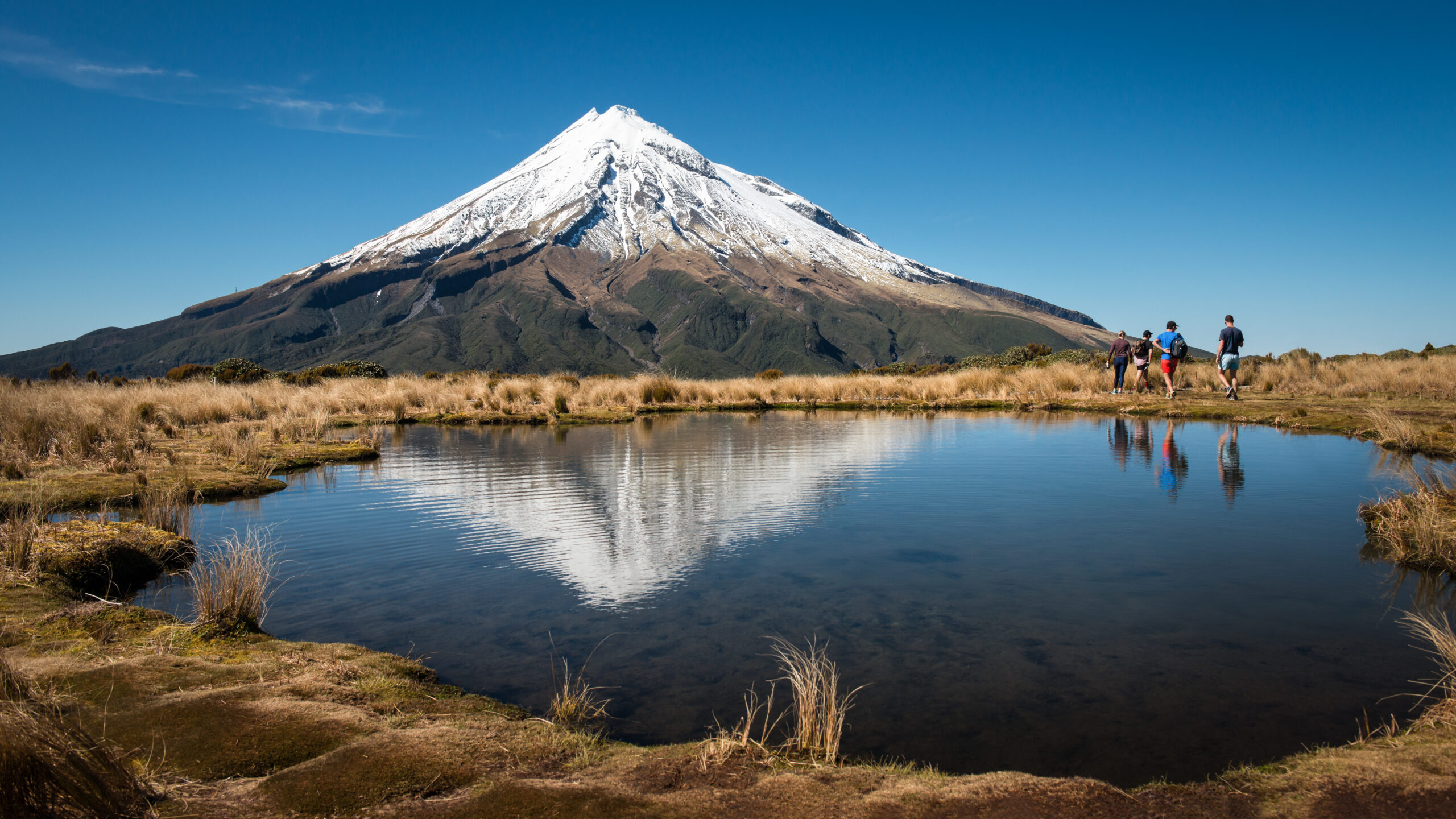
At 2,518 meters, Mount Taranaki rises in near-perfect symmetry from New Zealand’s North Island coastline — a sacred Maori ancestor mountain and one of the most photographed volcanoes in the world. The summit climb is also one of New Zealand’s most dangerous, averaging 2-3 fatalities annually. The complete 2026 guide to the North Egmont route, conditions, and what climbing this peak actually requires.
Mount Taranaki stands alone. The 2,518-meter stratovolcano rises in near-perfect symmetry from the agricultural plains of New Zealand’s North Island, isolated from any other significant mountains. The visual impact is immediate — Taranaki dominates regional skylines from every angle, often described as one of the most symmetrically perfect volcanoes anywhere in the world. Comparisons to Japan’s Mount Fuji are common, and the resemblance is real enough that Hollywood productions including The Last Samurai (2003) used Taranaki as a stand-in for Fuji. For climbers, the peak offers something rare: a genuine alpine challenge at modest elevation, accessible from a major highway, set within New Zealand’s second-oldest national park.
The mountain also carries reputational weight that climbers should not dismiss. Mount Taranaki is widely regarded as the most dangerous mountain in New Zealand by recorded deaths, averaging 2-3 fatalities per year over the past decade. The danger doesn’t come from extreme technical difficulty — the standard summer route is achievable for fit hikers — but from the mountain’s notorious capacity for sudden weather changes. Clear morning conditions can deteriorate into violent storms within an hour. The exposed upper slopes offer no shelter. Hypothermia, falls on icy terrain, and route-finding errors in low visibility cause most of the casualties. The mountain demands respect that its modest 2,518m elevation might otherwise suggest is unnecessary.
For Maori, Mount Taranaki is far more than a climbing objective. The mountain is a tupuna — an ancestor — central to the spiritual identity of multiple iwi (tribes) of the Taranaki region. In 2023, New Zealand’s parliament passed legislation recognizing Taranaki Maunga as a legal person, granting the mountain itself the same rights as a natural person under New Zealand law. The legislation reflects the depth of Maori connection to the peak and the partnership between iwi and the New Zealand Crown in protecting the mountain’s spiritual and ecological integrity. Climbers visiting Taranaki Maunga participate in this cultural relationship whether they intend to or not.
Find Hotels, Flights & Trips for the World’s Best Hiking Destinations
The Global Summit Guide Travel Shop on Expedia — curated for outdoor adventurers, mountaineers, and serious hikers. Patagonia to the Alps. Nepal to the Rockies. Curated lodging for every region we cover.
Explore Travel Shop on Expedia →This guide covers what you need to climb Taranaki in 2026. The standard North Egmont route in detail. The seasonal conditions that determine whether your trip is a hiking achievement or a serious alpine mountaineering objective. The Maori cultural context that shapes how visitors engage with the mountain. Safety considerations from the mountain’s high casualty rate. Current 2026 access situation including the North Egmont Visitor Centre construction running through December 2026. And honest assessment of who should and shouldn’t attempt this climb — because Taranaki is more committing than first-time visitors typically realize.
Mount Taranaki / Egmont At a Glance
The essential reference facts for Mount Taranaki. Detailed sections follow below.
| Summit elevation | 2,518 m (8,261 ft) |
|---|---|
| Official names | Taranaki Maunga (Maori, primary), Mount Taranaki, Mount Egmont |
| Location | Egmont National Park, Taranaki region, North Island, New Zealand |
| Coordinates | 39.2967°S, 174.0644°E |
| Mountain type | Stratovolcano (dormant; last eruption circa 1755) |
| Park | Egmont National Park (1900) — New Zealand’s second-oldest national park |
| Cultural status | Tupuna (ancestor) in Maori tradition; granted legal personhood by NZ Parliament in 2023 |
| First recorded ascent | December 23, 1839 — James Heberley and Ernst Dieffenbach (German naturalist) |
| Distance from New Plymouth | 28 km southeast (~35 minutes by car) |
| Standard route | North Egmont Summit Route via Tahurangi Lodge and The Lizard |
| Trailhead | North Egmont Visitor Centre (940 m) |
| Key waypoints | Tahurangi Lodge (1,520 m), Hongi Valley wooden stairs, The Lizard ridge (2,000 m), summit crater |
| Total distance (round trip) | ~12.5 km |
| Total elevation gain | ~1,630 m (5,348 ft) |
| Typical summit day length | 8-10 hours round trip (4-5 hrs up, 3-3.5 hrs down) |
| Best season for non-mountaineers | January to April (New Zealand summer) |
| Winter/spring season | May to November — full alpine mountaineering experience required |
| Fatalities (recent decade average) | 2-3 per year — among the most dangerous mountains in New Zealand |
| Permits/fees | None — free access to Egmont National Park |
| 2026 guided cost | NZD $400-$1,500 depending on program type |
| Nearest gateway town | New Plymouth (28 km) or Stratford (12 km) |
| Nearest airport | New Plymouth Airport (NPL) — 30 minutes; Auckland (AKL) — 5 hours drive |
2026 access alert. Car parking at the North Egmont road end is limited until December 2026 due to construction of the new visitor centre. Large trucks use the road during construction — drive carefully and expect occasional delays. The Department of Conservation strongly recommends carpooling or using a shuttle service when planning a visit. The North Taranaki Visitor Centre remains open but has temporarily moved to a building in the upper car park above the construction site. Freedom camping at the North Egmont Road end is prohibited. Climbers can overnight camp at Stratford Plateau car park on Pembroke Road or Mangorei Road car park instead.
Why Mount Taranaki Matters: Culture, Geology, and a Reputation for Danger
Taranaki occupies a singular position in New Zealand mountaineering and culture. The peak combines four distinctive elements. Geological perfection — it’s one of the world’s most symmetrical stratovolcanoes. Deep indigenous spiritual significance as a sacred Maori tupuna granted legal personhood in 2023. Accessible climbing logistics, just 35 minutes from New Plymouth airport. And a serious safety reputation as the most dangerous mountain in New Zealand by recorded deaths. Few peaks anywhere combine these elements in the same way.
The Symmetrical Stratovolcano
Mount Taranaki is widely considered one of the most geometrically perfect volcanoes on Earth. The cone rises from sea level to 2,518 meters in near-perfect symmetry, presenting an essentially identical profile from every angle of approach. Geologically, Taranaki is a young volcano — the current cone formed within the past 130,000 years, making it geologically active in volcanic terms. The last confirmed eruption was around 1755, and the mountain is classified as dormant rather than extinct. Scientists monitor Taranaki continuously, and statistical analysis suggests the mountain has approximately a 30-50% probability of significant eruption within the next 50 years — though predictions at this temporal scale carry meaningful uncertainty.
The Fuji of New Zealand
The visual comparison to Mount Fuji isn’t subjective marketing. Taranaki and Fuji share nearly identical geological structure — both are stratovolcanoes, both formed through similar volcanic processes, both reach approximately 2,500-3,800 meters from coastal plains. The resemblance is striking enough that Hollywood productions including The Last Samurai (2003, starring Tom Cruise) used Taranaki as a primary stand-in for Mount Fuji. The substitution worked thanks to New Zealand’s similar volcanic geometry and lower production costs compared to filming in Japan. Photographers, painters, and tourism marketing have long since recognized that Taranaki photographs at a level few peaks match.
The Sacred Mountain
For Maori, particularly the iwi (tribes) of the Taranaki region, the mountain is a tupuna — an ancestor — central to spiritual identity and cultural practice. Traditional Maori cosmology positions Taranaki as a mountain god who once stood alongside other North Island volcanoes (Tongariro, Ruapehu, Ngauruhoe) but moved west to his current location after a mythological conflict over a female mountain. The depth of this cultural significance cannot be separated from modern climbing experience. In 2023, the New Zealand Parliament passed legislation recognizing Taranaki Maunga (the formal Maori name) as a legal person — granting the mountain itself the same rights as a natural person under New Zealand law. The legislation reflected a partnership between iwi and the Crown to formalize Maori spiritual relationships with the mountain.
The Most Dangerous Mountain
Taranaki’s casualty record is the defining safety reality of climbing this peak. The mountain averages 2-3 deaths per year over the past decade, making it the most dangerous mountain in New Zealand by recorded fatalities — exceeding even the technical alpine peaks of the Southern Alps. The danger source isn’t extreme technical difficulty. The standard summer route is achievable for fit, prepared hikers. The danger source is weather. Taranaki sits in isolation on the west coast of the North Island, exposed to weather systems from the Tasman Sea. Clear morning conditions can deteriorate into violent storms within an hour. The exposed upper slopes offer no natural shelter. Most casualties result from hypothermia, falls on icy terrain in deteriorating weather, or route-finding errors in low visibility.
Taranaki’s casualty record is real, not marketing. The 2-3 fatalities per year figure isn’t industry exaggeration designed to sell guided trips. It’s a documented statistical pattern over decades that reflects the mountain’s unique combination of accessibility, weather exposure, and the gap between perceived and actual difficulty. The peak attracts large numbers of casual visitors who underestimate the conditions. Many fatalities occur in apparent walk-up summer scenarios where climbers were caught by weather changes without proper preparation. Respect the mountain’s casualty record. The casualty rate is your evidence that Taranaki should not be attempted in marginal conditions, regardless of how “easy” the trail looks at the trailhead.
Who Should Climb Mount Taranaki?
Taranaki is genuinely deceptive. The trailhead at 940 meters feels like a hike, not a mountaineering objective. The first hour on a 4WD track reinforces that impression. By the time conditions matter — at The Lizard or above — climbers are already committed to the day. Honest pre-trip self-assessment matters more on Taranaki than on most peaks of its modest 2,518m elevation.
Mount Taranaki Is Appropriate For:
Fit hikers with prior mountain experience. Climbers who’ve completed major hikes (Tongariro Alpine Crossing, Routeburn Track, similar New Zealand or international tramps) and have moved comfortably on rocky or scree terrain have the foundation. The 1,630m elevation gain over 12.5km demands real fitness.
Climbers comfortable with route-finding in variable conditions. The upper sections of the route can be difficult to follow in fog or snow. Climbers who can navigate confidently with map and compass, and who have prior experience with rapidly changing mountain weather, perform better than those expecting marked trails throughout.
Visitors during stable summer weather (January to April). The summer window offers the best conditions and the lowest casualty risk. Climbers who can be flexible with their dates and wait for genuinely stable weather have a much safer experience than those locked into rigid travel schedules.
Climbers willing to turn back. Taranaki’s high casualty rate often involves climbers who continued despite deteriorating conditions. The peak rewards climbers who set a turnaround time before starting and stick to it regardless of how close to the summit they are.
Cultural-experience-focused visitors. Climbers who value engaging with the Maori cultural context — visiting the Visitor Centre, reading the cultural information, respecting the spiritual significance of the mountain — find their Taranaki experience considerably richer than purely sport-focused ascents.
Photographers seeking iconic compositions. Few mountains anywhere offer Taranaki’s combination of symmetrical perfection and accessible viewpoints. Photographers visiting New Zealand often plan trips specifically around the mountain’s photographic opportunities.
Mount Taranaki Is Not Appropriate For:
Casual day-hikers without mountain experience. The trailhead’s accessibility creates false confidence. Visitors expecting a tourist walk encounter conditions and exposure they aren’t prepared for. Choose lower elevation walks (Wilkies Pools, Enchanted Walk, Pouakai Tarns) instead.
Climbers in winter or spring without alpine experience. May through November requires full mountaineering equipment (crampons, ice axe, ropes), avalanche assessment skills, and extensive alpine experience. Most casualties occur during shoulder season ascents by inadequately prepared climbers.
Climbers attempting in marginal weather. The single most important safety decision on Taranaki is not attempting the summit in marginal conditions. Climbers locked into tight schedules who can’t accept a turnaround day face elevated risk.
Solo climbers without route experience. The combination of weather exposure and route-finding complexity makes solo climbing on Taranaki genuinely dangerous. Even experienced climbers benefit from partner support during difficult conditions.
Climbers ignoring DOC route advice. The Department of Conservation provides real-time weather and route condition advice at the North Egmont Visitor Centre. Climbers who skip the Visitor Centre check-in and don’t consult current conditions are statistically over-represented among casualties.
Mount Taranaki Maori Cultural Context: Taranaki Maunga as Tupuna
Climbing Taranaki without understanding the cultural context misses something essential about the experience. The mountain is sacred to Maori in ways that visitors should understand before arrival.
Taranaki Maunga: The Ancestor Mountain
For Taranaki iwi (tribes) including Te Ati Awa, Taranaki, Ngati Ruanui, Ngati Tama, Nga Ruahine, Nga Rauru Kiitahi, Ngati Mutunga, and Ngati Maru, the mountain is a tupuna — a literal ancestor. Maori cosmology positions natural features not as resources or sights but as living relatives connected to specific lineages. The mountain has personality, will, mood, and presence. Speaking of climbing the mountain in Maori contexts typically uses language reflecting relationship rather than conquest.
The 2023 Legal Personhood Legislation
In 2023, the New Zealand Parliament passed legislation recognizing Taranaki Maunga as a legal person, granting the mountain itself the same legal rights as a natural person. The legislation formalized a partnership between iwi and the New Zealand Crown to govern the mountain’s protection. Taranaki joined the Whanganui River (2017) and Te Urewera (2014) as natural features with legal personhood in New Zealand — a globally unique legal framework that reflects Maori spiritual relationships with the natural world. The legislation doesn’t restrict climbing but does formalize how the mountain is governed, protected, and treated as a legal entity.
What This Means for Climbers
The cultural context affects climbing experience in practical ways. The North Egmont Visitor Centre presents bilingual information acknowledging the mountain’s tupuna status. Trail signage uses both Maori and English names. Photographers and visitors are asked to respect culturally sensitive areas — particularly summit-area locations where some Maori traditions discourage standing on the actual summit point. Some iwi welcome respectful visitor engagement; others prefer minimal visitor impact on specific cultural sites. The Department of Conservation provides clear guidance through Visitor Centre staff.
How to engage respectfully. Visitors who want to engage thoughtfully with Taranaki Maunga’s cultural significance have many options. First, stop at the North Egmont Visitor Centre and read the bilingual cultural information. Use Maori names (Taranaki Maunga) alongside English names when appropriate. Respect any cultural site markers or guidance encountered on the trail. Refrain from explicitly standing on the highest summit point if your guide or signage indicates this preference. Pack out all waste rigorously. Speak quietly in culturally significant locations. Finally, ask Visitor Centre staff about appropriate cultural protocols. The mountain has welcomed visitors for generations — respectful engagement is welcomed and adds depth to the climbing experience.
The Standard Routes Up Mount Taranaki
Three established routes lead to Mount Taranaki’s summit. The North Egmont Summit Route is the standard line used by 90%+ of climbers. The East Egmont and South Egmont routes provide alternatives but are less developed and rarely used by non-mountaineers.
| Route | Trailhead | Difficulty | Round trip | Usage |
|---|---|---|---|---|
| North Egmont Summit Route (Standard) | North Egmont VC (940m) | Strenuous tramping / alpine | ~12.5 km | ~90% of climbers |
| East Egmont (Manganui) | Stratford Plateau (~1,180m) | Alpine — requires experience | ~10 km | ~5% of climbers |
| South Egmont (Dawson Falls) | Dawson Falls VC (~890m) | Strenuous tramping | ~16 km | ~5% of climbers |
Route 1: The North Egmont Summit Route (Standard — 90% of climbers)
The North Egmont Summit Route is the standard climbing line on Mount Taranaki. The route ascends from the North Egmont Visitor Centre at 940m through a sequence of distinct sections. These include a 4WD service road, a private alpine lodge, a wooden-staircase valley, open scoria slopes, and a rocky climbing ridge called The Lizard. The final crater traverse leads to the summit. Each section presents different terrain and different management considerations. Most climbers complete the round trip in 8-10 hours, with the descent significantly faster than the ascent due to scree-glissading on the loose slopes.
The Full Route Breakdown
- North Egmont Visitor Centre (940m): Starting point. Check in with DOC staff for current weather and route conditions. Note 2026 construction limitations on parking. Last reliable water and toilets.
- Translator Road (940-1,500m): 4WD service road climbing through native forest to the communications tower. Approximately 1.5 hours of moderate hiking. This section reinforces a deceptively casual impression of the climb.
- Tahurangi Lodge (1,520m): Privately owned by the Taranaki Alpine Club. Sleeps 26+ with full kitchen, mains power, flush toilets. Kept locked — bookings essential through the club. Convenient snack and weather-check stop.
- Hongi Valley wooden stairs (1,520-1,800m): DOC-installed wooden staircase climbing through the valley to counter erosion. Stair sections are physically demanding but route-finding is straightforward here.
- Open scoria slopes (1,800-2,000m): Loose volcanic rock and scree. The terrain becomes more exposed with no shelter. Route-finding requires attention. Significantly more demanding than the lower sections.
- The Lizard ridge (2,000-2,400m): A prominent rocky ridge requiring genuine scrambling. Hands needed for balance and progress on some sections. Significant exposure on either side. This is the climbing crux.
- The narrow rocky ledge (~2,400m): A narrow, exposed traverse shortly before reaching the crater. Significant fall potential if conditions are wet or icy.
- Summit crater (2,450m): The usually snow-filled crater is finally reached. Most climbers traverse approximately 10 minutes south across the snow.
- Final scoria slope and summit (2,518m): A final loose scoria slope to the western rim — the true summit. Note: some Maori traditions discourage standing on the highest point. Many climbers respect this by stopping just below the summit cairn.
- Descent: Reverse the route. The scoria descent below The Lizard can be done with controlled scree-glissading, reducing time considerably. Estimated 3-3.5 hours back to the trailhead.
Strengths
- Most direct route to the summit
- Well-marked through Tahurangi Lodge
- Visitor Centre check-in supports safety
- Established infrastructure (wooden stairs, lodge access)
- Achievable as single day from accommodation in New Plymouth
Considerations
- 2026 parking limitations at North Egmont trailhead
- The Lizard ridge demands real scrambling skill
- Upper slopes offer no shelter from weather
- Casualty rate is highest among NZ mountains
- Weather window discipline is essential
- Winter ascent requires full alpine equipment
Route 2: East Egmont (Manganui Ski Area)
The East Egmont route starts from the Stratford Plateau car park at approximately 1,180m elevation — the highest of the three main trailheads. The route accesses The Manganui Ski Area (a small club ski field) and continues to the summit via the eastern slopes. The terrain is more technical than the North Egmont route, with steeper sections and more exposed climbing on the upper mountain. This route sees significant winter ski mountaineering traffic but fewer summer climbers compared to the standard line.
Strengths
- Highest trailhead reduces total elevation gain
- More technical content for experienced climbers
- Less crowded than North Egmont route
- Excellent winter ski mountaineering line
Considerations
- More technical terrain demands experience
- Steeper sections increase fall potential
- Less developed infrastructure than North Egmont
- Best suited to experienced mountaineers
Route 3: South Egmont (Dawson Falls Visitor Centre)
The South Egmont route ascends from Dawson Falls Visitor Centre at approximately 890m on the south side of the mountain. The route is longer than the North Egmont line (approximately 16 km round trip versus 12.5 km), but offers a different perspective and considerably less crowding. The character of the climbing is similar to the North Egmont route in technical terms — strenuous tramping through forest and scree, with a more committing upper section. Many climbers complete this route as part of the Around the Mountain Circuit, a 4-5 day track that circumnavigates the entire mountain.
Strengths
- Less crowded than North Egmont
- Different viewpoint of the mountain
- Naturally combines with Around the Mountain Circuit
- Cultural sites at Dawson Falls add depth
Considerations
- Longer total distance than standard route
- Steeper upper section demands more effort
- Less developed infrastructure
- Not appropriate for first-time Taranaki climbers
Mount Taranaki Climbing History: From 1839 to 2026
For centuries before any European contact, the Maori iwi of the Taranaki region maintained deep spiritual relationships with the mountain. The peak was — and remains — a tupuna (ancestor) central to local cosmology. Traditional Maori cosmology positions Taranaki as a mountain god who once stood with other North Island volcanoes (Tongariro, Ruapehu, Ngauruhoe) before moving west to his current location following a mythological dispute. Knowledge of the mountain’s slopes, weather, and ecology was extensive long before any climbing record existed.
Captain James Cook sighted the mountain on January 11, 1770, during his first voyage of HMS Endeavour. Cook named the peak “Mount Egmont” after John Perceval, 2nd Earl of Egmont, the recent First Lord of the Admiralty. The naming followed the conventions of the period — assigning peaks to British political and naval figures — with no recognition of existing Maori names. The Egmont name persisted in European maps and English-language usage for two centuries.
The first recorded ascent of Mount Taranaki was completed by James Heberley and German naturalist Ernst Dieffenbach on December 23, 1839. Dieffenbach was working with the New Zealand Company conducting scientific surveys. The ascent established the mountain as a climbing objective in European mountaineering literature and provided the first detailed scientific descriptions of the upper mountain. Heberley’s account documented the route conditions, though specific path details have been refined considerably by subsequent climbers.
The New Zealand government established Egmont National Park in 1900 — making it New Zealand’s second-oldest national park after Tongariro (1887). The park protected approximately 33,500 hectares of forest and alpine terrain surrounding the mountain. The park’s boundaries form a near-perfect circle around the peak — a quirky cartographic distinction visible on satellite images. The park designation formalized public access to the mountain while preserving its ecological integrity.
The early 20th century saw major development of climbing infrastructure on Mount Taranaki. The Taranaki Alpine Club (TAC), founded in 1891, became one of New Zealand’s most active mountaineering clubs. Tahurangi Lodge at 1,520m was established and maintained by the club, providing climbers with shelter at a critical elevation on the standard route. The North Egmont and Dawson Falls Visitor Centres were established to support growing visitor numbers. Climbing instruction and weather education emerged as standard offerings.
The Manganui Ski Area was developed on the east face of Mount Taranaki during the 1950s. The small ski field operated through the late 20th century, providing recreational skiing on the mountain’s relatively short snow season. Ski mountaineering on Taranaki — including descents from the summit during stable winter conditions — became an established discipline. Multiple ski routes were documented, with Surrey Road and Pleasant Valley earning reputations as committing adventure ski descents.
The New Zealand Geographic Board formally recognized “Mount Taranaki / Mount Egmont” as equally valid names for the mountain in 1986. The dual naming acknowledged the Maori name while preserving the European one. The decision reflected broader changes in New Zealand’s relationship with Maori cultural recognition through the 1980s. Both names continued in use through subsequent decades.
The Last Samurai (2003), starring Tom Cruise, used Mount Taranaki as a primary location for scenes set in 19th-century Japan featuring Mount Fuji. The geometric resemblance between Taranaki and Fuji made the substitution work convincingly on screen. The film’s release brought Taranaki to international audiences as “New Zealand’s Fuji.” Tourism interest grew considerably in the years following the film’s release.
The Treaty of Waitangi settlement between the New Zealand Crown and Taranaki iwi included provisions for the mountain’s future governance. The settlement framework established co-management arrangements between iwi and the Department of Conservation, formalizing Maori partnership in protecting Taranaki Maunga. The settlement laid the groundwork for the legal personhood legislation that would follow several years later.
The New Zealand Parliament passed legislation in 2023 recognizing Taranaki Maunga as a legal person with the same rights as a natural person under New Zealand law. The legislation followed similar precedents for the Whanganui River (2017) and Te Urewera (2014). The mountain joined a small global cohort of natural features with legal personhood — a legal framework that reflects Maori spiritual relationships with the natural world. The legislation didn’t restrict climbing but formalized governance arrangements and cultural protocols.
The 2024-2025 climbing seasons saw strong international visitor demand alongside continued domestic climbing. The North Egmont Visitor Centre is currently under reconstruction through December 2026, creating temporary parking limitations and access challenges. The temporary visitor centre operates above the construction site. Domestic Maori cultural programming has expanded, with bilingual signage now standard throughout Egmont National Park. The 2026 climbing season is currently active with conditions favorable through April for non-mountaineer summit attempts.
Mount Taranaki Safety: Understanding the Casualty Record
Taranaki’s casualty record is the defining safety reality of this mountain. The 2-3 fatalities per year average is statistically significant and reflects identifiable patterns. Understanding these patterns is the single most important pre-climb preparation any visitor can do.
Why Taranaki Is So Dangerous
The casualty rate doesn’t come from one factor — it comes from a combination that’s unique to this mountain. First, weather exposure: Taranaki sits in isolation on the west coast of New Zealand’s North Island, exposed to weather systems from the Tasman Sea. The peak generates its own weather and intercepts storms that may not be apparent at coastal level. Second, the gap between perceived and actual difficulty: the trailhead at 940m feels like a hike. The 4WD service road reinforces casual confidence. By the time conditions matter — at The Lizard or above — climbers are committed to the day. Third, the absence of shelter: above Tahurangi Lodge at 1,520m, there’s no natural or built shelter on the route. Climbers caught in storms have nowhere to wait out conditions. Fourth, accessibility: the mountain attracts large numbers of inexperienced visitors who underestimate the conditions. The combination produces consistent casualties year after year.
Common Casualty Patterns
| Pattern | Typical Scenario | Risk Mitigation |
|---|---|---|
| Weather change hypothermia | Clear morning attempt; afternoon storm; insufficient clothing | Carry full storm gear; check forecast carefully; turn back early |
| Falls on icy terrain | Spring/autumn ascent without crampons on unexpected ice | Carry crampons in shoulder season; check trail conditions |
| Lost in low visibility | Fog descent from summit; wrong route choice | Carry GPS; know route well; have turnaround time |
| Inadequate winter equipment | Late-season attempt without alpine gear | Winter requires full mountaineering kit; not a hike |
| Continuing past turnaround time | Almost-summit decisions in deteriorating conditions | Set turnaround time before starting; honor it |
Safety Practices That Work
- Stop at the North Egmont Visitor Centre before any summit attempt. DOC staff have real-time conditions information that can save lives.
- Watch the NZ Mountain Safety Council’s walk-through video. Available on the DOC website, the video covers route specifics and common hazards.
- Set a turnaround time and honor it. Most casualties involve climbers who continued past sensible turnaround times in marginal conditions.
- Carry comprehensive emergency gear. Full storm shell, warm layers, headlamp, emergency bivy, food, and water for an unexpected overnight.
- Tell someone your plan and turnaround time. Sign the intentions book at the Visitor Centre and have a backup contact who knows when to alert authorities.
- Wait for genuinely settled weather. “Forecast looks okay” isn’t sufficient. The forecast should indicate stable conditions for the full 10+ hours you’ll be exposed.
- Hire a guide in shoulder season or winter. Guides cost NZD $400-$800 per day and dramatically reduce risk on winter ascents.
Mount Taranaki Summit Day Timeline: Hour-by-Hour from North Egmont
Summit day on Mount Taranaki typically runs 8-10 hours round trip from the North Egmont Visitor Centre. Strong climbers complete the round trip in 7-8 hours. Slower parties may take 10-12 hours. The single most important timing consideration is starting early enough to summit before potential afternoon weather changes and descend in daylight.
Standard Mount Taranaki Summit Day — North Egmont (940m) to Summit (2,518m) and Return
The turnaround time discipline. Set a turnaround time BEFORE starting the climb. A common standard is: if you’re not at The Lizard by 11:00, turn around regardless of how close to the summit you feel. The casualty data shows that climbers who reach The Lizard after 11:00 and continue have considerably higher accident rates than those who turn back. Weather typically deteriorates in the afternoon. Descending The Lizard in deteriorating conditions is genuinely dangerous. Setting and honoring a turnaround time is the single most effective safety practice on Taranaki.
Which Taranaki Approach Fits Your Situation?
The choice on Mount Taranaki involves route selection, season timing, and whether to attempt the climb independently or with a guide. Use this matrix to match yourself.
Match Yourself to a Mount Taranaki Approach
When to Climb Mount Taranaki: Season-by-Season Analysis
January to April: Summer (Best for Non-Mountaineers)
The summer window offers the best conditions for non-mountaineer summit attempts. The mountain is typically clear of snow and ice except in the crater. Temperatures are warmest (though still cool at altitude). Days are longest. Weather is most stable, though Taranaki’s notoriety for sudden weather changes persists year-round. January and February are the most popular months. March and April offer slightly less crowded conditions with similar stable weather. This is the only season recommended for visitors without alpine mountaineering experience.
May to September: Winter (Alpine Mountaineering Required)
Winter ascents require full alpine mountaineering experience and equipment. The summit and upper slopes are typically snow-covered with significant ice. Crampons and ice axe are essential. Rope work may be required on the upper sections. The Manganui Ski Area operates a short ski season during this window. Most casualties on Taranaki concentrate in shoulder season and winter ascents by inadequately prepared climbers. Hire a guide unless you have documented alpine experience.
October to December: Spring Transition
Spring brings unpredictable conditions. Snow and ice persist on the upper mountain into November or December some years. Lower slopes may be clear while upper slopes remain in winter conditions. Climbers attempting this window should carry full alpine equipment and be prepared to turn back if conditions don’t permit safe progress. Many fatalities occur in spring by climbers who expected summer conditions and encountered winter-style terrain.
Weather Window Discipline (All Seasons)
Regardless of season, Mount Taranaki demands genuine weather discipline. The only days to attempt the summit are those with forecasts of settled conditions for the full 10+ hours you’ll be on the mountain. Marginal forecasts are not sufficient. “Looks okay” is not sufficient. The mountain is notorious for rapid deterioration — clear morning to violent storm in under an hour. Build flexibility into your schedule to wait for genuine stable weather. The mountain will be there next week.
Climbing Mount Taranaki in 2026: Cost Breakdown
Mount Taranaki is one of the most affordable major climbing destinations in New Zealand. Free park access, no permits, and short trip duration keep costs low for independent climbers with their own vehicle.
Independent Climbing Costs
| Cost Component | 2026 Amount (NZD) | Notes |
|---|---|---|
| Egmont National Park entry | $0 | Free access; no permits required |
| North Egmont parking | $0 | Free but limited until December 2026 (construction) |
| New Plymouth accommodation (per night) | $120-$300 | Hotels, motels, B&Bs; book ahead in summer peak |
| Stratford accommodation (per night) | $80-$200 | Closer to mountain; smaller selection of properties |
| Backpackers / hostels in New Plymouth | $30-$60 | Budget-friendly options for solo travelers and groups |
| Meals (New Plymouth restaurants) | $50-$100/day | Casual to mid-range dining |
| Fuel (Auckland to New Plymouth round trip) | $120-$180 | ~370 km each way; depends on vehicle |
| Personal climbing gear | $0-$500 | Crampons, ice axe rentable from outdoor shops if needed for winter |
| Total 2-3 day independent budget | $250-$700 | Excluding international travel and existing gear |
Guided Climbing Costs
| Program Type | 2026 Cost (NZD) | What’s Included |
|---|---|---|
| Single-day summer guided summit | $400-$650 per person | NZ certified guide, group size 1:3 to 1:5, basic gear |
| Single-day winter guided summit | $600-$900 per person | Alpine guide, smaller groups, crampons/ice axe instruction |
| Multi-day mountaineering course | $800-$1,500 per person | 2-3 day program combining skills training with summit attempt |
| Private 1:1 or 1:2 guiding | $600-$900 per day | Custom dates, dedicated guide attention |
When the guide investment pays off. Independent summer ascents in stable weather can be safely completed by fit, experienced hikers without paid guiding. However, the guide investment makes sense in several situations. Winter ascents and shoulder season attempts. First-time climbers without prior alpine experience. Climbers without recent fitness preparation. Or any visitor who wants the safety margin from professional weather assessment. Given Taranaki’s casualty rate, the NZD $400-$900 cost of a guided ascent represents excellent value compared to the alternatives. A guide isn’t required by law, but the statistical evidence suggests guides prevent most casualties.
Gear Checklist for Mount Taranaki
Mount Taranaki gear requirements vary dramatically by season. Summer summer ascents require strenuous-tramping gear. Winter ascents require full alpine mountaineering equipment. The mountain’s weather exposure means storm gear is essential in any season — climbers caught in unexpected storms without proper layers face genuine danger.
Summer Climbing Essentials (January-April)
- Sturdy hiking boots — high-cut leather or synthetic boots with aggressive lugs; trail runners inadequate for the scoria sections
- Helmet — recommended for The Lizard ridge and crater sections
- Trekking poles — useful for the scree descent
- Gaiters — short gaiters keep scoria out of boots
- 30-40L backpack — enough for layers, food, water, emergency gear
- Sunglasses (Cat 3-4) — UV exposure on the upper mountain is significant
Clothing System (Year-Round)
- Base layer top and bottom — merino or synthetic; pre-dawn starts can be cold even in summer
- Hiking pants — quick-drying synthetic; convertible pants useful
- Mid-layer fleece or light insulated jacket — for cool starts and weather changes
- Heavy insulated jacket — for unexpected weather or rest stops
- Hardshell jacket — Gore-Tex or equivalent; ESSENTIAL on Taranaki regardless of forecast
- Hardshell pants — for storm conditions and winter ascents
- Warm hat / balaclava
- Sun hat or visor — UV protection during clear conditions
- Light gloves and heavy gloves — temperature variability is significant
Food, Water, and Safety
- Water — at least 2-3 liters — no reliable water sources on the upper route
- Energy food — bars, gels, trail mix; eat throughout the climb
- Emergency food — extra calories for unexpected delays
- Sunscreen SPF 30+ and lip balm with SPF
- Personal first aid kit — blister care, ibuprofen, basic supplies
- Headlamp with spare batteries — essential for pre-dawn starts and emergencies
- Emergency bivy or space blanket — REQUIRED on Taranaki given weather risk
- Personal locator beacon (PLB) — strongly recommended; can be rented from outdoor stores in New Plymouth
- Phone with offline maps — limited cell service above Tahurangi Lodge
- Detailed map and compass — for route-finding in low visibility
- Whistle — for emergency signaling
Winter / Shoulder Season Additional Gear (May-December)
- Crampons — for snow and ice on the upper route — see our Crampons Buyer’s Guide
- Ice axe — straight-shaft mountaineering axe — see our Ice Axe Guide
- Avalanche safety gear — beacon, probe, shovel for backcountry winter travel
- Mountaineering boots (B2-B3) — required for crampon use
- Climbing rope and harness — for technical winter sections
- Heavy insulated layers — temperatures can drop well below freezing on the upper mountain
- Goggles — for wind and snow on the upper sections
Frequently Asked Questions About Climbing Mount Taranaki
How tall is Mount Taranaki and where is it located?
Mount Taranaki (also called Mount Egmont) rises to 2,518 meters (8,261 feet) on the west coast of New Zealand’s North Island. The coordinates are 39.2967°S, 174.0644°E. The mountain is a near-perfectly symmetrical stratovolcano that dominates the Taranaki region’s skyline and forms the centerpiece of Egmont National Park (established 1900, New Zealand’s second-oldest national park). The peak is located approximately 28 km southeast of New Plymouth, the regional capital. For Maori, the mountain holds deep cultural and spiritual significance — it is considered a tupuna (ancestor) and Taranaki Maunga is now the formal designation following 2023 legislation that recognized the mountain as a legal personality.
How difficult is climbing Mount Taranaki?
Mount Taranaki is considered one of the most dangerous mountains in New Zealand despite its modest 2,518m elevation. The peak averages 2-3 fatalities per year over the past decade. Summer ascents (January through April) are technically achievable for fit hikers with proper preparation. The standard North Egmont route involves approximately 1,630m of elevation gain over 12.5km round trip on rocky scree slopes. The route includes a steep climbing section called “The Lizard” and a final scoria scramble. Winter and shoulder season ascents require full alpine mountaineering experience, crampons, ice axe, and rope work. The mountain’s danger comes from rapid weather changes — clear morning conditions can deteriorate into violent storms in under an hour.
What’s the standard route up Mount Taranaki?
The standard route up Mount Taranaki is the North Egmont Summit Route starting from the North Egmont Visitor Centre at 940m elevation. The route ascends the Translator Road (a 4WD track) to the communications tower, continues to Tahurangi Lodge at 1,520m (privately owned by the Taranaki Alpine Club), then enters Hongi Valley with DOC-installed wooden stairs to approximately 1,800m. From there, open scoria slopes climb west to The Lizard ridge at about 2,000m. The final 500m involves scrambling along The Lizard, across the usually snow-filled summit crater, and up a final scoria slope to the true summit at 2,518m. Total distance is approximately 12.5km return with 1,630m of elevation gain.
When is the best time to climb Mount Taranaki?
The best time for non-mountaineers to climb Mount Taranaki is January through April during the New Zealand summer, when the mountain is often clear of snow and ice (except in the crater). January and February offer the most stable weather with longer daylight hours. March remains an excellent window with cooler temperatures and reliable conditions. April is the late season transition with shorter days and increasing weather variability. May through November is winter mountaineering season requiring crampons, ice axe, rope work, and alpine experience. The only days to attempt the summit are those with forecasts of settled conditions for the full 10+ hours you’ll be on the mountain.
How much does climbing Mount Taranaki cost in 2026?
Climbing Mount Taranaki is essentially free for independent climbers. Egmont National Park has no entry fees or climbing permits. Parking at the North Egmont Visitor Centre is free, though limited until December 2026 due to construction of the new visitor centre. Independent climbers should budget approximately NZD $50-$120 per day for accommodation in New Plymouth or Stratford, plus fuel and food. Guided climbs are available from New Zealand mountaineering operators, typically running NZD $400-$800 per person for a single-day guided summit ascent. Winter mountaineering courses on Taranaki run NZD $800-$1,500 for multi-day programs.
Why is Mount Taranaki so dangerous?
Mount Taranaki’s danger comes from a unique combination of factors. First, weather exposure — the peak sits in isolation on the west coast of New Zealand’s North Island, exposed to weather systems from the Tasman Sea and capable of rapid deterioration. Second, the gap between perceived and actual difficulty — the accessible trailhead and 4WD service road give false confidence; conditions matter most where climbers are already committed to the day. Third, the absence of shelter above Tahurangi Lodge at 1,520m. Fourth, accessibility — the mountain attracts inexperienced visitors who underestimate the conditions. The 2-3 fatalities per year average is statistically significant and reflects identifiable patterns that proper preparation can largely avoid.
Do I need a guide to climb Mount Taranaki?
A guide is not legally required for climbing Mount Taranaki. Summer ascents in stable weather can be completed safely by fit, experienced hikers without paid guiding. However, guides are strongly recommended in several situations. Winter ascents (May to November) and shoulder season attempts (October-December and April-May). First-time climbers without prior alpine experience. Climbers without recent fitness preparation. Any visitor who wants the safety margin that comes with professional weather assessment. Given the mountain’s casualty rate, the NZD $400-$900 cost of a guided ascent represents excellent value. New Zealand-certified mountain guides operate from New Plymouth, Stratford, and Auckland.
What’s the Maori cultural significance of Mount Taranaki?
For Maori, particularly the iwi (tribes) of the Taranaki region, Mount Taranaki is a tupuna — an ancestor — central to spiritual identity and cultural practice. The mountain is treated as a living entity, not as a sport climbing objective. Traditional Maori cosmology positions Taranaki as a mountain god who once stood alongside other North Island volcanoes before moving west to his current location following a mythological dispute. In 2023, the New Zealand Parliament passed legislation recognizing Taranaki Maunga as a legal person, granting the mountain itself the same rights as a natural person under New Zealand law. Visitors are encouraged to engage respectfully — stop at the Visitor Centre, read the cultural information, and consider not standing on the absolute summit point in respect for tupuna status.
Can I climb Mount Taranaki in winter?
Winter ascents of Mount Taranaki are possible but require full alpine mountaineering experience and equipment. From May through November, the upper mountain is typically snow-covered with significant ice. Climbers need crampons, ice axe, mountaineering boots, and often rope work for the steeper sections. The mountain’s weather exposure is even more dangerous in winter than summer. Most fatalities on Taranaki concentrate in shoulder season and winter ascents by inadequately prepared climbers. Strongly consider hiring a guide for any winter or shoulder season attempt. Multi-day winter mountaineering courses (NZD $800-$1,500) are an excellent way to gain alpine skills while attempting the summit safely.
What’s the deal with the North Egmont Visitor Centre in 2026?
The North Egmont Visitor Centre is undergoing construction of a new facility, with the project running through December 2026. During construction, parking at the North Egmont road end is limited — large construction trucks use the road and the parking area is reduced. The Department of Conservation strongly recommends carpooling or using shuttle services when planning a visit. The North Taranaki Visitor Centre remains open but has temporarily moved to a building in the upper car park above the construction site. Freedom camping is prohibited at the North Egmont Road end. Alternative overnight camping is available at Stratford Plateau car park or Mangorei Road car park. Plan ahead and arrive early if attempting a summit climb during 2026.
Mount Taranaki Planning Resources
Sources & Further Reading
- Department of Conservation New Zealand (DOC) — Taranaki Maunga Summit Climb official information
- SummitPost — Mt Egmont/Taranaki North Route comprehensive route description
- SummitPost — Mt Egmont/Taranaki comprehensive guide for climbing community
- ClimbNZ — Summit climbs from North Egmont detailed route information
- ClimbNZ — Taranaki Mt Egmont winter ski mountaineering guide
- The Outbound — Summit Mt. Taranaki, Egmont National Park trip report
- New Zealand Spirit — Mt Taranaki summit guide with safety statistics (April 2026)
- New Zealand Mountain Safety Council — Taranaki Maunga walk-through video and safety resources
- Taranaki Alpine Club — Tahurangi Lodge information and historical climbing records
- Wikipedia — Mount Taranaki reference for elevation, history, geology, and 2023 legal personhood legislation
- James Heberley and Ernst Dieffenbach — 1839 first ascent account in New Zealand Company records
- The Last Samurai (2003) — film production records using Taranaki as Mount Fuji stand-in
Last updated: May 24, 2026. Next scheduled update: December 2026 (post-Visitor Centre construction completion).
Planning a New Zealand Climbing Trip?
Mount Taranaki is one of New Zealand’s most iconic climbing objectives, ideally combined with other North Island peaks (Tongariro, Ruapehu, Ngauruhoe) or with South Island alpine peaks. See our complete mountain guides for the broader New Zealand mountaineering picture.
View All Mountain Guides →Was this helpful?
🏔Related peaks nearby
🧭Explore & compare
Global Summit Guide is an independent mountaineering resource founded in 2026. The team combines first-hand trekking and climbing experience with in-depth research and professional health and nutrition review to help climbers choose objectives, prepare properly, and stay safe.
Health, altitude, and nutrition content is reviewed by Taylor Ludlow (Registered Nurse) and Brigg Hoopes (Nutritionist).
What We Don't Know Yet
Mountain information changes quickly. This box explains the limits of what this page can responsibly promise.
- Weather, snowpack, avalanche risk, road access, and route conditions can change quickly and may be different on your climbing dates.
- Route conditions, trailhead access, crevasse exposure, stream crossings, and rescue access may vary from published planning guidance.
- Visa, passport, vaccination, border, insurance, and local transportation rules may change before your trip.
Verify current conditions with official land managers, guide services, local forecasts, and current route reports before booking or climbing.
Part of this Global Summit Guide cluster
Explore the complete Mountains guide for more context, routes, planning links, and related resources.
Mountaineering, rock and ice climbing, glacier travel, and high-altitude activity are inherently dangerous and can result in serious injury or death. The information on Global Summit Guide is provided for general informational and educational purposes only and is not a substitute for professional instruction, qualified guiding, proper equipment, or your own judgment and experience.
Route conditions, weather, snowpack, permits, regulations, and hazards change constantly and may differ from what is described here. Details may be incomplete, out of date, or contain errors. Always verify current information with local authorities, certified guides, and official sources before making any decision in the mountains.
Nothing on this site is medical, legal, or financial advice. Our fitness, acclimatization, altitude, and nutrition content is general in nature; consult a qualified physician before beginning any strenuous exercise program or exposing yourself to high altitude.
You are solely responsible for your own safety and decisions. To the fullest extent permitted by law, Global Summit Guide and its team accept no liability for any loss, injury, damage, or expense arising from use of, or reliance on, this information. By using this site you acknowledge these risks and accept these terms.
Some links on this site may be affiliate links. If you buy through them we may earn a small commission at no extra cost to you; this never affects our recommendations.
Global Summit Guide recommendation path
Next Best Mountain to Research
Use these recommendations to continue the right planning path instead of stopping on one page.
Use current permit, weather, route, and operator information before booking or climbing.