Mount Erebus: The World’s Southernmost Active Volcano
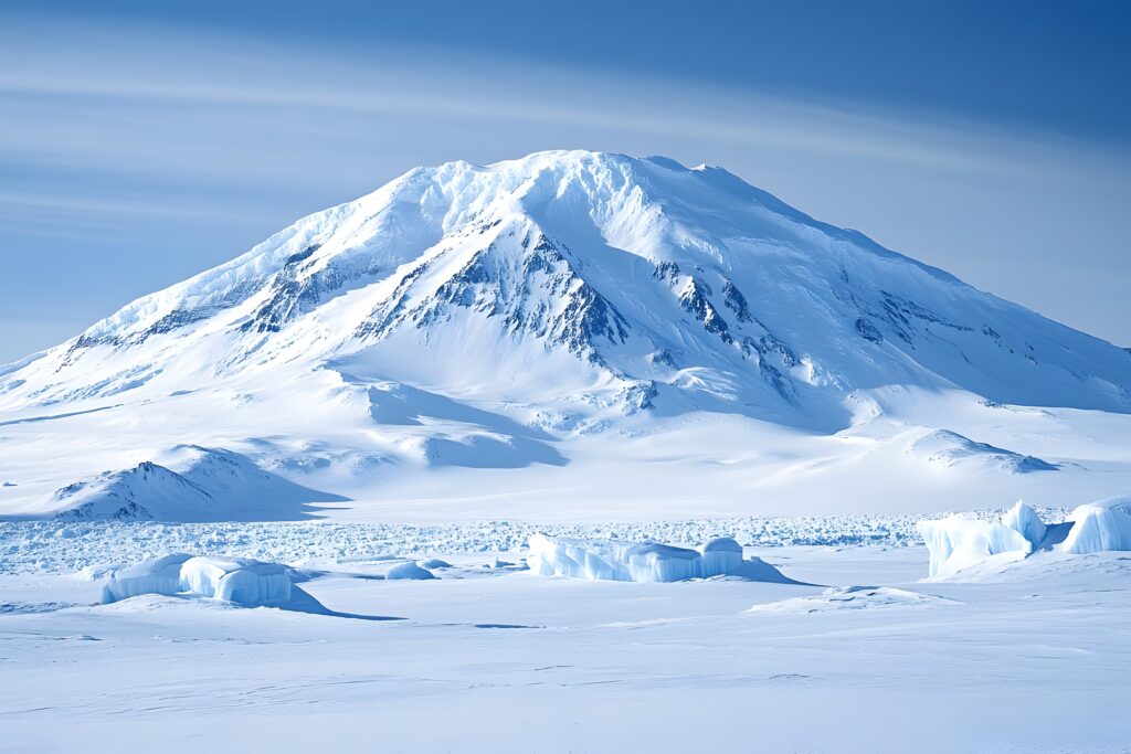
, Antarctica’s Burning Mountain
The world’s southernmost active volcano at 3,794m on Ross Island, Antarctica. Home to one of only a handful of persistent lava lakes on Earth, continuously active since at least 1972. Site of the catastrophic 1979 Air New Zealand Flight 901 disaster — New Zealand’s deadliest peacetime tragedy. A volcano essentially closed to general climbing access.
Mount Erebus is the world’s southernmost active volcano — a 3,794-meter (12,448-foot) stratovolcano on Ross Island, Antarctica, located within the Ross Dependency claimed by New Zealand (under abeyance through the Antarctic Treaty System). Erebus is the second-most prominent mountain in Antarctica after Mount Vinson, the second-highest volcano in Antarctica after the dormant Mount Sidley, and one of only a handful of volcanoes worldwide with a persistent active lava lake — a body of molten lava continuously exposed in its inner crater that has been documented as active since at least 1972, and probably substantially longer. The volcano was first sighted by Sir James Clark Ross’s expedition on January 27, 1841, and was named after Ross’s flagship HMS Erebus (named for the Greek primordial deity of darkness, son of Chaos). The first ascent occurred during Sir Ernest Shackleton’s Nimrod Expedition on March 10, 1908. But Mount Erebus’s most consequential modern history is anchored not by climbing but by the catastrophic Air New Zealand Flight 901 disaster of November 28, 1979 — when a sightseeing DC-10 crashed into the mountain’s lower slopes during a navigation error, killing all 257 people on board. The 1979 disaster remains New Zealand’s deadliest peacetime tragedy and the deadliest aviation accident in Antarctic history. Today, Mount Erebus is essentially closed to general climbing — access is restricted under the Antarctic Treaty Environmental Protocol and practically limited to scientific researchers, government officials, and authorized support staff working with national Antarctic programs at McMurdo Station (US) or Scott Base (NZ). This guide covers the volcano’s geological character, the 1979 disaster’s full history, the limited reality of access for non-scientists, the Volcanic Seven Summits context, and the substantial scientific importance of one of Earth’s most distinctive volcanoes — a mountain whose primary significance is educational and historical rather than recreational.
Mount Erebus Location & Antarctic Conditions
Mount Erebus is located on Ross Island, in McMurdo Sound off the coast of Victoria Land in West Antarctica. The summit coordinates are 77.5297°S, 167.1533°E. McMurdo Station (US Antarctic Program) sits approximately 35 kilometers (22 miles) southwest of the summit, and Scott Base (New Zealand’s main Antarctic base) is located near McMurdo. Air access to the region is exclusively via the US Air National Guard and Royal New Zealand Air Force from Christchurch, New Zealand, with no commercial flights permitted. Ross Island also hosts three inactive volcanoes — Mount Terror (3,230m), Mount Bird (1,765m), and Mount Terra Nova (2,130m).
Weather data approximated for Ross Island region near coordinates 77.5°S, 167.2°E. Summit temperatures at 3,794m are dramatically colder than McMurdo Station readings — typically averaging -20°C in summer and -50°C in winter at the summit plateau. The volcano operates in continuous daylight (December-February) or continuous darkness (June-August) depending on season due to extreme southern latitude.
Mount Erebus At a Glance
| Summit elevation | 3,794 m (12,448 ft) — world’s southernmost active volcano; sources range 3,792-3,795m |
|---|---|
| Location | Ross Island, McMurdo Sound, Ross Dependency, Antarctica (claimed by New Zealand; in abeyance under Antarctic Treaty) |
| Coordinates | 77.5297°S, 167.1533°E |
| Geographic superlatives | World’s southernmost active volcano; 2nd most prominent mountain in Antarctica (after Mount Vinson); 2nd highest volcano in Antarctica (after dormant Mount Sidley); highest point on Ross Island; 34th most prominent peak in the world |
| Volcano type | Stratovolcano (composite cone) of distinctive phonolite composition; part of McMurdo Volcanic Group |
| Geological age | Rock age approximately 1.3 million years |
| Lava lake | One of only a few persistent active lava lakes on Earth; 250m wide, 100m deep inner crater; active since at least 1972, probably substantially longer |
| Summit crater | 500 x 600 meters wide, 110 meters deep, elliptical; contains the lava-lake-bearing inner crater |
| Last confirmed major eruption | 2020; continuous low-level Strombolian activity throughout 2021-2026 per satellite monitoring |
| Discovery | January 27, 1841 — sighted by Sir James Clark Ross expedition; named after HMS Erebus (Greek god of darkness) |
| First ascent | March 10, 1908 — Edgeworth David and party during Sir Ernest Shackleton’s Nimrod Expedition |
| 1979 disaster | November 28, 1979 — Air New Zealand Flight 901 (DC-10) crashed into Mount Erebus; 257 killed (237 passengers + 20 crew); NZ’s deadliest peacetime disaster |
| Tectonic setting | Terror Rift, part of West Antarctic Rift System; thinned continental crust (~20km); driven by Erebus hotspot |
| Climbing access | Essentially closed to general public; restricted to scientific researchers and authorized support staff via McMurdo (US) or Scott Base (NZ) |
| Nearest stations | McMurdo Station (US, ~35km SW); Scott Base (NZ, near McMurdo) |
| Sister Ross Island volcanoes | Mount Terror (3,230m, extinct), Mount Bird (1,765m, extinct), Mount Terra Nova (2,130m, extinct) |
Why Mount Erebus Matters: One of Earth’s Most Distinctive Volcanoes
Mount Erebus occupies a unique position in global volcanology, geography, and aviation history. Three converging factors make Mount Erebus substantially more significant than its elevation alone suggests, and explain why it remains one of the most-discussed volcanoes in the world despite being essentially inaccessible to most climbers.
The Southernmost Active Volcano on Earth
Mount Erebus is, simply, the southernmost volcano on Earth still actively erupting. At 77.5°S latitude, the volcano sits closer to the South Pole than any other active volcanic vent. This extreme geographic position produces a distinctive volcanic environment found nowhere else: the magmatic heat of an active stratovolcano operating within a permanently glaciated landscape; persistent volcanic gas emissions interacting with sub-zero atmospheric conditions to produce more than 100 distinctive “ice fumaroles” — towers of ice that form around gas vents on the volcano’s flanks; and a research access window defined by Antarctic summer (December-March) when continuous daylight permits the substantial logistics required for any human activity in the region. No other active volcano on Earth provides comparable conditions for studying magmatic processes in pristine polar conditions, and Mount Erebus has become one of the most scientifically important volcanic research sites in the world as a result.
The Persistent Lava Lake — One of Only a Handful Worldwide
Mount Erebus contains one of only a small handful of persistent active lava lakes on Earth — a body of molten lava continuously exposed in the volcano’s inner crater. The lake sits within a 250-meter-wide, 100-meter-deep inner crater nested inside the larger 500×600-meter summit crater. The lake has been documented as continuously active since 1972 (when the Mount Erebus Volcano Observatory began continuous monitoring), and probably has been active for substantially longer based on the volcano’s geological history. Mount Erebus’s lava lake exists alongside only a few comparable features worldwide — Mount Nyiragongo (Democratic Republic of Congo), Mount Yasur (Vanuatu), Erta Ale (Ethiopia), Kīlauea (Hawaii, episodically), and a few others. Erebus’s lake is distinctive for its phonolite composition — an alkaline magma type uncommon in active volcanoes — and for the persistent Strombolian eruption pattern that ejects volcanic bombs onto the crater rim. The lava lake’s persistence and the volcano’s extreme polar location have made Erebus a substantial natural laboratory for volcanological research.
The 1979 Air New Zealand Disaster
Mount Erebus’s most consequential modern history is anchored not by climbing or volcanology but by the November 28, 1979 crash of Air New Zealand Flight 901 into the mountain’s lower slopes, killing all 257 people on board. The disaster — a DC-10 sightseeing flight that flew into the mountain due to a navigation coordinate error combined with white-out conditions — was New Zealand’s deadliest peacetime tragedy and the deadliest aviation accident in Antarctic history. The crash sent shockwaves through a country of only three million people, where nearly everyone knew someone on the flight. Subsequent investigation produced the Chippindale Report (blaming pilot error) and the Mahon Report (famously blaming the airline for an “orchestrated litany of lies”), establishing one of the most consequential aviation safety controversies in history. The 1979 disaster fundamentally shaped New Zealand aviation culture, ended commercial Antarctic sightseeing flights for over two decades, and gave Mount Erebus a profound national significance in New Zealand that transcends its volcanological importance. The wreckage site on the mountain’s lower slopes is now a protected area requiring special Antarctic Treaty permits for entry — a continuing memorial to the victims.
The honest framing. Mount Erebus is not a “climb” in the standard recreational sense — it is a natural and historical phenomenon. For climbers reading this guide as part of a Volcanic Seven Summits research effort, the practical reality is that Erebus is by far the most logistically inaccessible of the seven, requiring scientific or government affiliation that 99% of climbers will never obtain. For everyone else, this guide provides the substantial context — geological, historical, and human — that makes Mount Erebus one of the most significant mountains on Earth despite its limited recreational accessibility.
Who Can Realistically Access Mount Erebus?
Mount Erebus’s access reality is fundamentally different from any other major peak. The mountain is not closed by terrain difficulty or weather — it is closed by international treaty, national policy, and the absence of any commercial logistics infrastructure. Understanding the access reality is essential for anyone considering Mount Erebus as a future objective.
Who Currently Accesses Mount Erebus:
Scientific researchers with national Antarctic program affiliation. The substantial majority of human presence on Mount Erebus consists of scientific researchers working with the United States Antarctic Program (USAP) via McMurdo Station, Antarctica New Zealand via Scott Base, or smaller programs from other Antarctic Treaty signatory nations. These researchers obtain access through formal scientific grant processes, institutional partnerships with national Antarctic agencies, and multi-year scientific project approvals. The Mount Erebus Volcano Observatory (which operated continuous seismic and infrasonic monitoring from 1972 to 2016) was the principal scientific operation focused on the volcano itself.
Authorized support staff working with national Antarctic programs. McMurdo Station hosts approximately 1,000 people during peak summer (October-February) — predominantly support staff including cooks, mechanics, electricians, IT specialists, helicopter pilots, and maintenance personnel. Some of these positions occasionally include opportunities for incidental Mount Erebus exposure as part of support operations, though direct summit access typically requires specific scientific justification.
Government officials and diplomatic visitors. A small number of government officials, parliamentarians, and accredited journalists visit McMurdo and Scott Base each year, occasionally including site visits relevant to Mount Erebus. These access opportunities are not generally available to the public.
Specialized expedition members with scientific or media sponsorship. A very small number of expeditioners have summited Mount Erebus outside the standard scientific program framework — typically through extensive arrangements involving scientific media coverage, documentary film production, or specialized commercial Antarctic operators with substantial logistics resources. These opportunities are not advertised and require substantial pre-arrangement.
Who Cannot Currently Access Mount Erebus:
General tourists and recreational climbers. No commercial tour operator currently offers Mount Erebus climbing expeditions to general clients. Neither the United States nor New Zealand permits commercial flights to use the Antarctic airstrips that would be required for tourist access to Ross Island. Climbers seeking to summit Mount Erebus through standard commercial means simply cannot do so under the current regulatory framework.
Antarctic cruise passengers. The substantial Antarctic cruise tourism industry (approximately 100,000+ visitors annually) is concentrated on the Antarctic Peninsula and surrounding islands. Ross Island, on the opposite side of the continent, is essentially never visited by cruise tourism. The few specialized “fly-in” Antarctic operations that exist (e.g., Antarctic Logistics & Expeditions, ALE) focus primarily on Mount Vinson, the South Pole, and Antarctic interior locations — not Ross Island.
Volcanic Seven Summits aspirants without scientific affiliation. Climbers pursuing the Volcanic Seven Summits challenge (which includes Mount Erebus as Antarctica’s representative volcano in some lists, though others use Mount Sidley) cannot complete the challenge through normal commercial expedition channels. Practical achievement of the Volcanic Seven Summits requires substituting Mount Sidley (now accessible through specialized operators) or pursuing a substantially complex multi-year arrangement to access Erebus through scientific channels.
The Volcanic Seven Summits complication. The Volcanic Seven Summits challenge — climbing the highest volcano on each continent — has two competing lists. Some lists include Mount Erebus as Antarctica’s volcanic seven summit (because Erebus is the highest active volcano in Antarctica); others use Mount Sidley (because Sidley is the highest volcano in Antarctica overall, despite being dormant). The practical accessibility of Mount Sidley through specialized operators (Antarctic Logistics & Expeditions among others) versus Mount Erebus’s effective inaccessibility has led most modern Volcanic Seven Summits completionists to use Sidley as the Antarctic representative. Climbers should consult both lists and their preferred recognition body before committing to either peak.
Mount Erebus in the Antarctic Mountain Context
Mount Erebus exists within a substantially small ecosystem of Antarctic peaks accessible to humans. Understanding the broader Antarctic mountaineering context helps contextualize Mount Erebus’s distinctive position.
| Peak | Elevation | Type | Access Status | Significance |
|---|---|---|---|---|
| Mount Vinson | 4,892m | Non-volcanic; granite | Commercial expeditions available | Antarctica’s highest peak; Seven Summits objective |
| Mount Sidley | 4,285m | Dormant volcano | Specialized operators offer access | Antarctica’s highest volcano; Volcanic Seven Summits |
| Mount Erebus | 3,794m | Active stratovolcano | Essentially closed to general access | Southernmost active volcano; persistent lava lake |
| Mount Terror | 3,230m | Extinct volcano | Same restrictions as Erebus | Ross Island; named after HMS Terror |
| Mount Terra Nova | 2,130m | Extinct volcano | Same restrictions as Erebus | Ross Island; between Erebus and Terror |
| Mount Bird | 1,765m | Extinct volcano | Same restrictions as Erebus | Ross Island; northern peak |
| Deception Island | ~540m | Active volcano | Antarctic cruise stop | Antarctica’s other active volcano |
Climbers seeking Antarctic mountain experience overwhelmingly target Mount Vinson (commercial access established) or Mount Sidley (specialized operator access). Mount Erebus, despite being one of the most fascinating volcanoes on Earth, remains substantially out of reach for normal commercial channels.
Mount Erebus History: From Ross’s 1841 Discovery to the 1979 Disaster
Mount Erebus has one of the most consequential documented histories of any volcano outside the Mediterranean and Pacific volcanic belts. From its January 1841 discovery by Sir James Clark Ross — a moment captured during an active eruption — to the 1979 Air New Zealand disaster that made the mountain a household name in New Zealand, Mount Erebus has been a site of consequential human experience across nearly two centuries.
Mount Erebus was actively erupting for millennia before any human observation. Geological evidence from ice core sampling and surrounding lava deposits indicates substantial volcanic activity across the past 1.3 million years (the approximate age of the modern Erebus cone), with the persistent lava lake pattern probably extending across much of the volcano’s recent geological history. No indigenous human population ever inhabited Antarctica, so no pre-modern human observation of the volcano exists.
Mount Erebus was first sighted by humans on January 27, 1841, during Sir James Clark Ross’s British Antarctic Expedition (1839-1843). Ross’s expedition consisted of two ships — HMS Erebus and HMS Terror — which had been heavily reinforced for ice navigation. The expedition was conducting magnetic and oceanographic research in the southern oceans when it sighted the smoking volcano on the western side of Ross Island. Ross named the peak Mount Erebus after his flagship vessel, and named a neighboring peak (now extinct) Mount Terror after the expedition’s second ship. In Greek mythology, Erebus was a primordial deity personifying darkness — the son of Chaos and the personification of the deep darkness from which all came. The naming proved tragically prophetic across the next 138 years. Both HMS Erebus and HMS Terror would go on to play central roles in Sir John Franklin’s disastrous 1845-1848 Arctic expedition to find the Northwest Passage, in which both ships and all 129 officers and men were lost — vanishing into the Canadian Arctic with little to explain their passing. The ships’ eventual wrecks were not found until 2014 (Erebus) and 2016 (Terror) in the Canadian Arctic.
The first ascent of Mount Erebus was completed on March 10, 1908, by a party of six members of Sir Ernest Shackleton’s Nimrod Expedition (the British Antarctic Expedition 1907-1909). The successful summit team consisted of Tannatt William Edgeworth David (Australian geologist, expedition scientific leader), Douglas Mawson (later famous as leader of his own Antarctic expeditions), Alistair Mackay (expedition medical officer), Eric Marshall, Jameson Adams, and Philip Brocklehurst. The ascent took five days from a base camp at the foot of the mountain, with the climbing party experiencing substantial cold exposure, altitude effects, and the unique challenge of climbing toward an actively erupting summit crater. The summit team reached the crater rim and observed the active lava lake — the first documented direct human observation of the persistent lake that defines the volcano. The 1908 ascent established Mount Erebus as a legitimate climbing objective, though substantial subsequent climbing history was limited by Antarctic access restrictions.
McMurdo Station was established by the United States in 1956 in preparation for the International Geophysical Year (1957-1958). The station sits approximately 35 kilometers southwest of Mount Erebus summit and became the primary logistics hub for substantial scientific operations on Ross Island and across much of Antarctica. McMurdo’s establishment fundamentally changed Mount Erebus access from a rare expedition objective to a regular scientific research site, enabling the continuous monitoring and research operations that would follow.
Scott Base was established by New Zealand in 1957, also in preparation for the International Geophysical Year. The base is located near McMurdo at 77°51’S 166°45’E and named after Captain Robert Falcon Scott (leader of two earlier British Antarctic expeditions, including the tragic 1910-1913 expedition that reached the South Pole). Scott Base accommodates approximately 85 people during summer and 10-14 over winter, and continues to support substantial New Zealand scientific research on Mount Erebus and surrounding regions.
The Antarctic Treaty was signed on December 1, 1959, by 12 nations including all those with territorial claims in Antarctica. The treaty entered into force in 1961 and fundamentally established the modern framework for Antarctic activity — designating the continent as a scientific preserve, prohibiting military activity, freezing territorial claims (including New Zealand’s claim to the Ross Dependency where Mount Erebus is located), and establishing the protocol for international scientific cooperation that continues to govern Mount Erebus access today.
The Mount Erebus Volcano Observatory (MEVO) was established in 1972, beginning continuous seismic and infrasonic monitoring of the active lava lake and surrounding volcanic system. MEVO’s documentation established the scientific consensus that the lava lake has been continuously active since at least 1972, and probably substantially longer. The observatory’s continuous monitoring produced an unprecedented dataset on long-term active lava lake behavior, providing substantial scientific contribution to global volcanology. MEVO suspended its on-site seismic and infrasonic monitoring program in 2016, with subsequent monitoring transitioning to satellite-based observation primarily via Sentinel-2.
Air New Zealand began operating scheduled Antarctic sightseeing flights in February 1977 — 11-hour return scenic flights from Auckland that flew passengers over Antarctica without landing. The flights followed a popular route over McMurdo Sound and Ross Island, with experienced Antarctic guides providing commentary via the aircraft’s public-address system. The flights operated successfully and without major incident for nearly three years, becoming a popular tourist attraction with substantial advance booking.
On November 28, 1979, at approximately 1:50 PM New Zealand time, Air New Zealand Flight 901 (a McDonnell Douglas DC-10-30 registered ZK-NZP) crashed into the lower slopes of Mount Erebus at 77°25’30″S 167°27’30″E, killing all 257 people on board — 237 passengers and 20 crew. The aircraft was operating the scheduled sightseeing route from Auckland with Captain Jim Collins and First Officer Greg Cassin in command. Neither pilot had previously flown the Antarctic route, but the flight was considered straightforward for experienced commanders. Critical to the disaster: the flight plan navigation coordinates had been altered shortly before the flight without the pilots being informed during their pre-flight briefing — the briefing had used the old coordinates. The aircraft thus believed it was flying over McMurdo Sound when it was actually on a track directly into Mount Erebus. White-out conditions (“sector white-out” — a substantially recognized Antarctic phenomenon where snow and cloud merge visually to eliminate horizon and terrain references) made the mountain visually invisible. The DC-10 impacted the lower slopes at approximately full cruising speed, killing all aboard instantly. Victims included 200 New Zealanders, 24 Japanese, 22 Americans, 6 British, 2 Canadians, 1 Australian, and others. The wreckage trail extended approximately 600 meters across the snow. Recovery operations involving the New Zealand Police and US Navy took weeks to complete, with the bodies of all 257 victims eventually identified and returned to families across the world. The accident remains New Zealand’s deadliest peacetime disaster and the deadliest aviation accident in Antarctic history.
The 1979 disaster generated two competing official investigations. The Chippindale Report, completed in June 1980 by Chief Inspector of Air Accidents Ron Chippindale, concluded that the disaster was the result of pilot error — specifically, the captain’s decision to descend below the minimum safe altitude. The Mahon Inquiry, led by Justice Peter Mahon and reporting in April 1981, fundamentally contradicted Chippindale, finding that the airline bore principal responsibility for the disaster through poor procedures, inadequate pre-flight briefing of the changed navigation coordinates, and what Mahon famously characterized as “an orchestrated litany of lies” in the airline’s testimony to the inquiry. The Mahon Report was subsequently challenged through legal proceedings; the Judicial Committee of the Privy Council ultimately ruled in 1983 that Mahon’s specific finding of conspiracy was a breach of natural justice and not supported by the evidence, though Mahon’s substantive criticism of the airline’s procedures stood. The Chippindale-Mahon controversy became one of the most consequential aviation safety controversies in history and reshaped how aviation accident investigations approach human factors.
The Protocol on Environmental Protection to the Antarctic Treaty (the Madrid Protocol) was signed in 1991 and entered into force on January 14, 1998. The protocol designated Antarctica as a “natural reserve devoted to peace and science” and established the substantial environmental protection framework that governs all human activity on the continent, including Mount Erebus access. The protocol requires special permits for any Antarctic activity, mandates environmental impact assessment for substantial operations, and prohibits any commercial mineral resource activity. The 1979 disaster wreckage site on Mount Erebus is now a protected area under the Madrid Protocol, requiring special permits for entry as a memorial site.
In 2016, the Mount Erebus Volcano Observatory suspended its on-site seismic and infrasonic monitoring program after 44 years of continuous operation. Subsequent monitoring transitioned to satellite-based observation, primarily via the European Space Agency’s Sentinel-2 mission. The suspension reflected substantial logistical and funding constraints rather than reduced scientific interest in the volcano. Satellite monitoring has documented continued lava lake activity throughout 2016-2026 and produced the substantial visual record of Mount Erebus’s recent activity.
The most recent confirmed major eruptive event at Mount Erebus occurred in 2020. Throughout 2021-2026, Sentinel-2 satellite imagery has consistently shown an active lava lake in the inner crater, with occasional smaller secondary lakes and distinctive white gas plumes. The volcano’s persistent low-level Strombolian activity continues without interruption. McMurdo Station and Scott Base remain the primary access points, with continued scientific operations and the substantial logistical infrastructure that has defined Ross Island activity for over six decades. Climbing access remains essentially restricted to scientific researchers and authorized support staff. The 1979 disaster site continues to function as a memorial protected area, with the substantial 40-plus year commemoration of the victims observed annually in New Zealand.
The Climbing Routes on Mount Erebus (Restricted Access)
Mount Erebus has documented climbing routes from approximately a century of scientific and expedition activity, though the substantial majority of human access to the volcano occurs through helicopter-supported scientific operations rather than ground-based climbing. For the rare individuals who have access to attempt the mountain, the following routes have been documented.
| Route | Difficulty | Approach | Notes |
|---|---|---|---|
| Fang Glacier Route (Standard) | Non-technical to PD | Helicopter-supported from McMurdo to ~2,500m base | The standard modern scientific access route |
| Edgeworth David 1908 Route | Non-technical to PD | Historic foot approach from Ross Island sea level | The original first-ascent route; rarely repeated |
| Helicopter-deposit + Summit Day | Non-technical | Direct helicopter delivery to high camps | Most common modern scientific access |
Route 1: The Modern Scientific Access Pattern
The substantial majority of modern Mount Erebus ascents occur through helicopter-supported scientific operations rather than ground-based mountaineering expeditions. The typical access pattern: helicopter transport from McMurdo Station’s air operations to a high-altitude landing zone at approximately 2,500-3,500m on the volcano’s flank; establishment of a temporary scientific camp at the helicopter drop point; summit attempt from camp during favorable weather windows; helicopter pick-up upon completion of the scientific objectives.
The Fang Glacier route — the most commonly used approach — accesses the upper volcano via a relatively low-angle glacier-and-scree path that is non-technical in good conditions. Climbers operate in standard polar mountaineering gear (double-boots, crampons, ice axe, sleeping bag rated to -40°C minimum), with substantial logistics support that distinguishes scientific operations from independent mountaineering. Summit conditions are extreme: temperatures averaging -20°C summer and -50°C winter, substantial wind exposure, and the unique experience of working near an actively erupting lava lake with associated volcanic gas exposure (sulfur dioxide, hydrogen sulfide, and other irritants).
Route 2: The Historic Edgeworth David 1908 Route
The original first-ascent route used by Edgeworth David and Nimrod Expedition party in 1908 began at sea level on Ross Island and ascended on foot through approximately 3,794 meters of total elevation gain to the summit crater. The historic route involved substantial multi-day camping at progressively higher elevations, with the climb taking approximately five days from base camp to summit. The 1908 route is rarely repeated in modern times because of the substantial logistics advantage of helicopter access — climbers with scientific affiliation typically use helicopter support to avoid the long approach, and climbers without scientific affiliation cannot access the mountain at all.
The historic route retains substantial significance as the original ascent path and as the route by which the persistent lava lake was first directly observed by humans. A handful of expeditions in recent decades have repeated the foot-approach route as a deliberate historical exercise, but these are rare.
A Typical Mount Erebus Summit Day: Scientific Operations Pattern
Mount Erebus summit days, when they occur, follow a substantially different pattern from standard recreational mountaineering — driven by the logistics of scientific research, the substantial cold exposure of extreme polar climbing, and the unique hazard of operating near an actively erupting lava lake. Below is the typical pattern for a modern helicopter-supported summit operation.
Standard Mount Erebus Summit Day — Helicopter-Supported Scientific Operation
The substantial unique hazards of Mount Erebus. Mount Erebus presents hazards substantially different from standard high-altitude climbing. Volcanic gas exposure at the crater rim is a substantial risk — sulfur dioxide, hydrogen sulfide, and other gases can produce respiratory injury, eye irritation, and substantially complicate breathing at altitude. Gas masks or substantial face protection are essential. The substantial cold (-20°C summer to -50°C winter) produces frostbite risk substantially faster than mid-latitude high-altitude exposure. The volcano’s persistent Strombolian eruptions occasionally eject volcanic bombs onto the crater rim — a substantial risk that requires alertness and willingness to retreat at signs of increased activity. The substantial isolation of Mount Erebus means that emergency evacuation is substantially more complex than on any commonly-climbed peak — helicopter rescue depends on weather windows that can disappear for days. The combination of these hazards is why Mount Erebus access is restricted to scientifically trained individuals with substantial Antarctic operations experience.
Mount Erebus Cost in 2026: The Reality of Scientific-Only Access
Mount Erebus has no commercial climbing cost structure because no commercial operator provides access to the mountain. The “cost” of Mount Erebus access is measured not in dollars but in scientific affiliation, multi-year program approval processes, and substantial career investment in Antarctic research. Below is the substantial honest cost framework for the various access pathways.
Access Pathway Costs (2026 Reality)
| Access Pathway | Cost / Investment | Probability of Success |
|---|---|---|
| National Antarctic program scientific position | Years of graduate study + grant funding + program approval | Very low for individuals without prior Antarctic research experience |
| USAP support staff position (McMurdo) | Application process; specialized skills required; multi-month deployment | Low; doesn’t guarantee Mount Erebus access |
| Specialized expedition with scientific sponsorship | $50,000-$200,000+ private logistics arrangement (rare) | Very low; depends on individual circumstances |
| Documentary or media production access | Substantial production budget; multi-year approval process | Very low; only for substantial productions |
| Comparison: Mount Sidley via ALE | $80,000-$120,000 commercial expedition | High for fit/experienced climbers; this is the realistic alternative |
| Comparison: Mount Vinson commercial expedition | $45,000-$70,000 commercial expedition | Very high for fit/experienced climbers |
The realistic alternative. Climbers seeking Antarctic mountain experience overwhelmingly target Mount Vinson (Antarctica’s highest peak, established commercial access through Antarctic Logistics & Expeditions and several other operators) or Mount Sidley (Antarctica’s highest volcano, accessible through specialized operators). Mount Vinson runs $45,000-$70,000 per climber for a 14-21 day expedition; Mount Sidley runs $80,000-$120,000 per climber due to substantial logistics complexity. Both are substantially expensive but achievable through normal commercial channels. Mount Erebus has no comparable commercial pathway and is essentially closed to climbers without scientific affiliation.
Mount Erebus Gear Requirements (For Scientific Access)
For the rare individuals with scientific access to Mount Erebus, gear requirements substantially exceed standard high-altitude expedition equipment due to the extreme polar conditions, the substantial cold exposure, and the unique hazards of operating near an active lava lake. The substantial majority of equipment is supplied by national Antarctic programs (USAP, Antarctica NZ) rather than personally purchased.
Cold-Weather Clothing System (Program-Supplied)
- Extreme cold weather (ECW) gear — full polar layering system rated to -50°C minimum
- Double-boots — Olympus Mons, Spantik, or equivalent rated for sustained polar conditions
- Down/synthetic expedition parka — 800+ fill power; rated to extreme polar conditions
- Insulated bib pants — full-side-zip for layering
- Multiple base layer systems — merino or synthetic
- Glove system — liner gloves, mid-weight gloves, mittens with overmitts
- Balaclava system — multiple weights for different conditions
- Polar-rated sleeping bag — typically -40°C rated
Climbing Equipment
- Crampons with anti-balling plates — 12-point steel, automatic compatibility
- Ice axe — general mountaineering axe, 60-70cm
- Climbing harness — alpine harness
- Climbing helmet — substantial protection from volcanic bomb ejecta
- Locking carabiners — 5-6 for rope-team use
- Belay device, prusiks, crevasse rescue gear — typically supplied by lead guide
Volcanic Hazard Protection
- Gas masks or respirators — protection from sulfur dioxide, hydrogen sulfide; essential at crater rim
- Sealed goggles — protection from volcanic gas and substantial UV at altitude
- Spare gas mask filters — substantial sulfur exposure degrades filters quickly
Hydration, Nutrition, and Personal Items
- Insulated water bottles — water freezes substantially fast at -20°C
- Thermos for hot drinks — substantial morale and warmth at the crater rim
- High-calorie expedition food — 5,000-6,000 kcal/day required in polar conditions
- Sunscreen SPF 50+ — substantial UV reflection from snow surfaces; 24-hour daylight
- Lip balm with SPF — substantial UV and wind exposure
- Glacier-rated sunglasses — Category 4; essential to prevent snow blindness
- Headlamp with spare batteries — for the brief twilight period or backup; cold-resistant lithium batteries
- Personal first aid kit — substantial blister/frostbite supplies, ibuprofen, electrolyte tablets
- Communications gear — VHF radio for McMurdo coordination; satellite communications backup
When Mount Erebus Is Accessible: Antarctic Season Dynamics
Mount Erebus access is dictated by the substantial Antarctic seasonal cycle — continuous daylight in summer (October-March), continuous darkness in winter (April-September), and substantial weather windows that constrain even the best-supported scientific operations.
October-March: Antarctic Summer — The Access Window
The substantial Antarctic summer runs October through March, with continuous daylight and substantially the most accessible conditions. McMurdo Station operates at peak capacity (~1,000 people) during this window, with regular helicopter operations supporting scientific activities on Mount Erebus. December-February represents the optimal climbing window with the warmest temperatures (typically -10°C to -25°C at the summit) and most reliable weather. The Air New Zealand sightseeing flights during 1977-1979 operated during this same November window, and the 1979 disaster occurred during a typical late-November scenic flight.
December-February: Peak Summer Window
December, January, and February represent the absolute peak of the Antarctic summer with continuous daylight, the warmest temperatures of the year, and the most reliable weather windows. The substantial majority of scientific operations on Mount Erebus occur during this window. Helicopter operations from McMurdo are substantially reliable, scientific staffing peaks, and the substantial logistics infrastructure supports concentrated research activity.
April-September: Antarctic Winter — Closed Period
The Antarctic winter (April-September) features continuous darkness, extreme cold (summit temperatures averaging -50°C), and substantially the most challenging conditions in any global mountaineering context. McMurdo Station operates with skeleton staff of ~200 winter-overs during this period, conducting limited operations. Mount Erebus climbing during winter is essentially impossible — no documented winter ascents exist, and even the substantial scientific operations are limited to satellite monitoring and very rare emergency activities.
Mount Erebus 2025 Activity Retrospective
The 2025 Mount Erebus season continued the substantial established pattern of ongoing volcanic activity, restricted human access, and primarily satellite-based monitoring. Below are the substantial patterns from the 2025 activity year.
Pattern 1: Continuous Lava Lake Activity
Sentinel-2 satellite imagery throughout 2025 confirmed continued persistent lava lake activity in Mount Erebus’s inner crater. The lake’s substantial pattern of low-level Strombolian eruptions, occasional larger bursts, and continuous gas plume emission remained substantially consistent with the pattern established since 1972. No major eruptive deviation was recorded during 2025, supporting the substantial scientific consensus that Mount Erebus’s activity is fundamentally stable across decadal timeframes.
Pattern 2: Continued McMurdo Operations
McMurdo Station operated through its standard summer-peak schedule during the 2024-2025 austral summer, with approximately 1,000 personnel during peak December-February. Scientific operations supporting Mount Erebus research continued through national Antarctic program affiliations, though substantial detail about specific 2025 research operations is not publicly available due to the substantial Antarctic Treaty environmental review processes.
Pattern 3: Climate Research Focus
The substantial 2020s emphasis on Antarctic climate research has driven increased scientific attention to Mount Erebus as a unique natural laboratory for studying long-duration volcanic processes in pristine polar conditions. Research collaborations between New Zealand, US, and European Antarctic programs have continued substantially throughout 2025, with multiple research papers and substantial scientific contribution to global volcanology continuing the substantial research tradition established by the Mount Erebus Volcano Observatory in 1972.
Pattern 4: No Climbing Access Changes
The 2025 access situation remained substantially unchanged from prior years — Mount Erebus remained closed to general commercial climbing access. No major policy changes from the United States, New Zealand, or Antarctic Treaty Secretariat altered the substantial restrictions that have been in place since the establishment of the Antarctic Treaty system. Climbers pursuing Antarctic mountain experience continued to focus on Mount Vinson and Mount Sidley as the substantial commercial alternatives.
Pattern 5: Substantial Continuing 1979 Disaster Commemoration
The November 28, 2024 anniversary of the 1979 Air New Zealand Flight 901 disaster — the 45th anniversary of New Zealand’s deadliest peacetime tragedy — was observed throughout New Zealand with substantial commemorative events, ongoing journalism, and continued family remembrance activities. The substantial passage of time has not diminished the substantial cultural significance of the disaster, and Mount Erebus retains its substantial position as a place of profound national meaning in New Zealand.
The substantial 2025 lesson. Mount Erebus in 2025 continued the substantial pattern of being one of the most distinctive volcanoes on Earth — continuously active, scientifically significant, historically consequential, and essentially closed to general public access. The substantial pattern is unlikely to change in the foreseeable future. The Antarctic Treaty framework that governs the volcano’s access reflects substantial international consensus that has been stable across more than six decades, and no substantial pressure exists to commercialize Antarctic mountain tourism beyond the established Mount Vinson and Mount Sidley access patterns. Climbers interested in Mount Erebus should approach the volcano as a substantial educational and historical subject rather than as a realistic climbing objective.
Frequently Asked Questions About Mount Erebus
Can you climb Mount Erebus as a tourist?
No, Mount Erebus is essentially closed to general tourist climbing. Access is restricted under the Antarctic Treaty Environmental Protocol and practically limited to scientific researchers, government officials, and authorized support staff working with national Antarctic programs at McMurdo Station (US) or Scott Base (NZ). The general public cannot independently access Ross Island — neither the US nor NZ permits commercial flights to use their Antarctic airstrips, and no commercial tour operator offers Mount Erebus climbing expeditions. For climbers pursuing the Volcanic Seven Summits challenge, this access restriction makes Erebus by far the most logistically difficult of the seven. Realistic alternatives include Mount Vinson (Antarctica’s highest peak, with established commercial expedition access) or Mount Sidley (Antarctica’s highest volcano, accessible through specialized operators).
How tall is Mount Erebus?
Mount Erebus has a summit elevation of 3,794 meters (12,448 feet), with sources varying between 3,792m and 3,795m. It is the second-most prominent mountain in Antarctica (after Mount Vinson at 4,892m) and the second-highest volcano in Antarctica (after the dormant Mount Sidley at 4,285m). With a prominence of 3,765 meters, Mount Erebus ranks as the 34th most prominent mountain in the world. Despite being lower than Vinson, Mount Erebus is substantially more famous due to being the world’s southernmost active volcano, containing one of only a few persistent active lava lakes on Earth, and being the site of the 1979 Air New Zealand disaster.
What is Mount Erebus’s lava lake?
Mount Erebus contains one of only a few persistent active lava lakes on Earth — a body of molten lava continuously exposed in the volcano’s inner crater. The lake sits within a 250-meter-wide, 100-meter-deep inner crater nested inside the larger summit crater. The lake has been continuously active since at least 1972. The lake consists of distinctive phonolite composition (an unusual alkaline magma type) and produces persistent Strombolian eruptions — small explosions ejecting volcanic bombs onto the crater rim. Mount Erebus’s lava lake is one of just a small handful of similar features worldwide, alongside Mount Nyiragongo, Mount Yasur, Kīlauea, Erta Ale, and a few others. Since the Mount Erebus Volcano Observatory suspended on-site monitoring in 2016, the lake has been primarily monitored via Sentinel-2 satellite imagery.
What happened to Air New Zealand Flight 901?
On November 28, 1979, Air New Zealand Flight 901 — a McDonnell Douglas DC-10-30 sightseeing flight from Auckland to Antarctica — crashed into Mount Erebus, killing all 257 people on board (237 passengers and 20 crew). The crash was the result of controlled flight into terrain — navigation waypoints had been altered shortly before the flight, but pilots weren’t briefed on the change. Combined with white-out conditions, the aircraft impacted the lower slopes at full cruising speed. The accident was New Zealand’s deadliest peacetime disaster and the deadliest aviation accident in Antarctica. Victims included 200 New Zealanders, 24 Japanese, 22 Americans, 6 British, 2 Canadians, and 1 Australian among others. Subsequent investigation produced the Chippindale Report (pilot error) and the Mahon Report (“orchestrated litany of lies”). The Privy Council later ruled Mahon’s specific conspiracy finding a breach of natural justice. The 1979 disaster fundamentally shaped New Zealand aviation culture and made Mount Erebus a place of profound national significance.
Is Mount Erebus still erupting?
Yes, Mount Erebus is one of only two active volcanoes in Antarctica (the other being Deception Island). The most recent confirmed major eruptive event was 2020, but the persistent lava lake produces continuous low-level Strombolian activity. Sentinel-2 satellite imagery during 2021-2026 has consistently shown an active lava lake. The volcano sits in the Terror Rift portion of the West Antarctic Rift System, where thinned continental crust and the Erebus hotspot drive ongoing magmatic activity. Mount Erebus’s persistent activity makes it one of the most scientifically important volcanoes in the world for studying long-duration eruptive systems.
Who discovered Mount Erebus?
Mount Erebus was first sighted by humans on January 27, 1841, during Sir James Clark Ross’s British Antarctic Expedition (1839-1843). Ross’s expedition consisted of two ships — HMS Erebus and HMS Terror — which had been heavily reinforced for ice navigation. The volcano was actively erupting when first sighted. Ross named the peak Mount Erebus after his flagship vessel, and named a neighboring peak Mount Terror after the expedition’s second ship. In Greek mythology, Erebus was a primordial deity personifying darkness, son of Chaos. Both HMS Erebus and HMS Terror later played central roles in Sir John Franklin’s disastrous 1845-1848 Arctic expedition, in which both ships and all 129 officers and men were lost.
Who made the first ascent of Mount Erebus?
The first ascent of Mount Erebus was completed on March 10, 1908, by a six-person party from Sir Ernest Shackleton’s Nimrod Expedition (British Antarctic Expedition 1907-1909). The summit team consisted of Tannatt William Edgeworth David (Australian geologist, expedition scientific leader), Douglas Mawson (later famous as leader of his own Antarctic expeditions), Alistair Mackay, Eric Marshall, Jameson Adams, and Philip Brocklehurst. The ascent took five days from base camp, with the party experiencing substantial cold exposure and the unique challenge of climbing toward an actively erupting summit crater. The summit team reached the crater rim and made the first direct human observation of the persistent lava lake — a moment of substantial geological significance.
How does Mount Erebus compare to Mount Vinson?
Mount Vinson (4,892m) is Antarctica’s highest peak and the standard objective for climbers pursuing the Seven Summits challenge. Mount Erebus (3,794m) is approximately 1,100m lower but substantially more famous due to its active lava lake and the 1979 disaster. The substantial practical difference is access: Mount Vinson has established commercial expedition access through Antarctic Logistics & Expeditions (ALE) and several other operators at approximately $45,000-$70,000 per climber for 14-21 day expeditions. Mount Erebus has no comparable commercial access pathway. For climbers seeking Antarctic mountain experience, Mount Vinson is the achievable objective; Mount Erebus is essentially closed. The Volcanic Seven Summits challenge complicates this somewhat — some lists use Erebus as Antarctica’s volcanic representative, but most modern completionists substitute Mount Sidley (Antarctica’s highest volcano, accessible through specialized operators at $80,000-$120,000) due to Sidley’s substantially better access.
What are Mount Erebus’s ice fumaroles?
Mount Erebus is unique worldwide for hosting more than 100 distinctive “ice fumaroles” — towers of ice that form around volcanic gas vents on the volcano’s flanks. The fumaroles form when warm volcanic gases (water vapor, sulfur dioxide, hydrogen sulfide) escape from cracks in the volcano’s surface and immediately freeze in the substantial sub-zero atmospheric conditions, building up over years and decades into towering ice structures sometimes reaching 5-10 meters in height. The interiors of these ice towers contain caves that are substantially significant for astrobiology research — the caves harbor unusual microbial life adapted to the combination of warm volcanic gases and extreme cold, making them substantial natural analogs for potential life on Mars, Jupiter’s moon Europa, and other extraterrestrial environments. The ice fumaroles are one of the most distinctive geological features on Earth and a substantial scientific resource that justifies continued Antarctic Treaty protection of the Mount Erebus area.
What is the Volcanic Seven Summits and is Mount Erebus on the list?
The Volcanic Seven Summits is a mountaineering challenge involving climbing the highest volcano on each of the seven continents. The challenge has two competing lists due to debate about which volcano represents Antarctica. The original Volcanic Seven Summits list (compiled by Dr. Sam Carter) includes Mount Sidley (4,285m, Antarctica’s highest volcano, though dormant) as Antarctica’s representative. An alternative list uses Mount Erebus (3,794m) as Antarctica’s representative because Erebus is the highest active volcano in Antarctica. The substantial practical question is access: Mount Sidley is accessible through specialized commercial operators at $80,000-$120,000, while Mount Erebus is essentially closed to general climbing access. Most modern Volcanic Seven Summits completionists use Sidley to complete the challenge. Climbers should consult their preferred recognition body before committing to either peak. The challenge is substantially more difficult than the standard Seven Summits due to the substantial volcanic-specific challenges and the substantial Antarctic access complications.
Mount Erebus Detailed Reference Guides
Sources & Further Reading
- Smithsonian Global Volcanism Program — Mount Erebus eruption history and geological data
- Mount Erebus Volcano Observatory (MEVO, 1972-2016) — historical monitoring data and scientific publications
- Wikipedia — Mount Erebus (elevation, geological data, eruption history)
- Wikipedia — Mount Erebus disaster (Air New Zealand Flight 901 detailed history)
- NASA Earth Observatory — Sentinel-2 satellite monitoring imagery of Mount Erebus lava lake
- Britannica — Mount Erebus comprehensive reference
- SummitPost — Mount Erebus climbing route descriptions and access information
- Chippindale Report (June 1980) — Official NZ aviation investigation of Flight 901
- Mahon Report (April 1981) — Royal Commission of Inquiry into Flight 901
- Justice Peter Mahon, “Verdict on Erebus” (1984) — book on the Royal Commission findings
- Erebus.co.nz — comprehensive resource on the 1979 disaster maintained by victims’ families
- United States Antarctic Program (USAP) — McMurdo Station operations
- Antarctica New Zealand — Scott Base operations
- Antarctic Treaty System Secretariat — environmental protocol and access regulations
- European Space Agency Sentinel-2 mission — current satellite monitoring imagery
Last updated: May 23, 2026. Next scheduled review: November 2026 (45+ year anniversary of 1979 disaster observance).


