
Last updated August 3, 2026
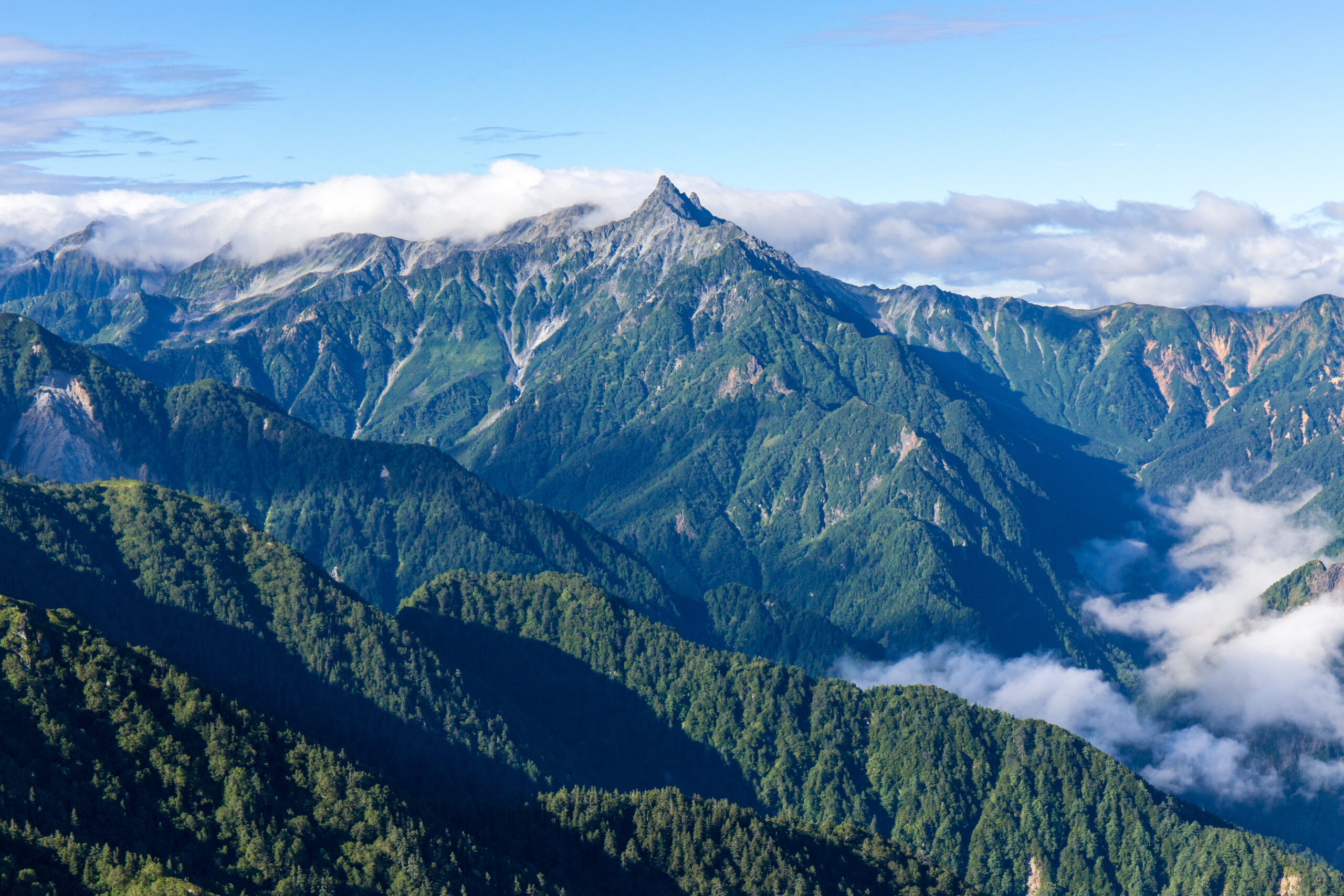
Mount Yari expedition update
The Matterhorn of Japan, a long hut-based hike with a sharp sting in the tail. This page tracks the routes, the chained summit block, the notorious Daikiretto, the huts and hiking-plan system, the season, and a go or no-go checklist. A single-mountain page in our Expedition Updates directory. Elevations in metres (feet).
The spear you climb on chains and ladders.
Yarigatake is the fifth-highest mountain in Japan and one of its most loved, a sharp rock spear at the head of the Northern Alps. The normal route is a long, multi-day hut-based walk, but it ends with a short, steep, exposed scramble up the summit spire on fixed iron chains and near-vertical ladders. It is not a beginner mountain.
There is no permit, but you should file a hiking plan, book huts ahead, and carry cash. And from Yari’s summit runs the Daikiretto, a knife-edge traverse to the Hotaka range that is one of the most dangerous trails in Japan. For the full route detail, see our Yarigatake guide.
Summit (10,433 ft)
The fifth-highest mountain in Japan.
Main season
Early August the sweet spot; huts run to late October.
File a hiking plan
Hut-based and cash only; reserve ahead.
Yarigatake stands in the Hida Mountains of the Northern Japan Alps, on the Nagano and Gifu border in Chubu-Sangaku National Park. Its name means spear peak, and the pyramid of rock at its summit has made it a rite of passage for Japanese climbers since the monk Banryu first climbed it in 1828. This page owns the current picture, the routes, the summit block, and the logistics. For the full history, day-by-day route detail, and gear, see our Yarigatake climb guide.
Season and status
A summer hut mountain, with a real early-season catch.
The main season runs from July to September, with early August widely regarded as the sweet spot for stable afternoon weather and alpine wildflowers, and late September into October bringing the famous autumn colours. The huts open around the spring Golden Week holiday and close in late October, after which the route shuts to general hikers. The catch is early July, when the upper Yarisawa can still hold snow and ice, and an ice axe and crampons may be needed; Yarisawa Lodge has posted signs warning less-equipped hikers to turn back. Check current conditions before you commit to an early-season attempt.
Why climbers love the spear
The Matterhorn of Japan, and a rite of passage.
Yarigatake earns its Matterhorn of Japan nickname from the clean rock spire that crowns it, visible from ridgelines across the range and instantly recognisable. For Japanese hikers it is one of the great aspirational peaks, a summit you work up to after easier mountains, and reaching the top of the spear on chains and ladders is a milestone in a climbing life. Walter Weston, the English missionary who helped bring alpinism to Japan, climbed and championed it, and it has anchored the culture of the Northern Alps ever since. The appeal is the combination: a long, beautiful valley and ridge walk, and a genuine bit of exposed climbing to finish.
The routes and the summit block
A long walk in, and a sharp climb out.
| Route | From | Character | Notes |
|---|---|---|---|
| Kamikochi / Yarisawa | Kamikochi | The classic and most popular line, following the Azusa River up the Yarisawa gorge. | About 39 km and 2,130 m of gain; two to four days. |
| Omote-Ginza traverse | Nakabusa Onsen | A spectacular high ridge over Tsubakuro and along the range to Yari. | More committing; a multi-day traverse. |
| Summit block | Yarigatake Sanso | The final 200 m of near-vertical rock on heavy iron chains and ladders. | Short but steep and exposed; 20 to 30 minutes, with queues in season. |
| Daikiretto | Toward Hotakadake | A knife-edge traverse linking Yari to the Hotaka range, for experienced climbers only. | One of the most dangerous stretches of trail in Japan. |
Most climbers take the Kamikochi and Yarisawa approach, a non-technical but long walk up the valley with one or more nights in huts before the summit push. Whatever the approach, the mountain saves its difficulty for the end: the final 200 m to the top is a near-vertical scramble on heavy iron chains and ladders, taking twenty to thirty minutes, with real exposure and, in season, queues both up and down. Wet or icy chains make it far more serious, so many climbers go for the summit at first light before the afternoon weather builds.
The Daikiretto
The knife-edge that starts where the easy climbing ends.
From Yari’s summit, a ridge runs south toward the Hotaka range and drops into the Daikiretto, a knife-edge traverse widely regarded as one of the most dangerous stretches of maintained trail in Japan. It is a long, highly exposed scramble on chains, ladders, and bolts, with sheer drops on both sides, and it would be graded a technical climb in many other countries. Climbers wear helmets, move deliberately, and pick settled weather.
The Daikiretto is not part of the normal Yari ascent and should not be attempted on the strength of it. It is for experienced climbers with a head for extreme exposure only, and it is unforgiving of a slip or a lapse in concentration. This page is educational and is not a substitute for the skills the traverse demands.
Huts, the hiking plan and access
The logistics visitors most often get wrong.
Yarigatake Sanso and the hut system
Yarigatake Sanso, a large classic mountain hut just below the summit at around 3,000 m, is the usual base, providing dinner, breakfast, and a futon, with more huts along the approach such as Yarisawa Lodge. Budget roughly 10,000 to 15,000 yen a night with two meals, bring cash because the huts do not take cards, and reserve ahead in peak season. Designated tent sites are available at some huts for a small fee.
Difficulty and altitude
A serious hike with an exposed finish.
Yarigatake is not a technical climb on its normal route, but it is a demanding one, with a long approach, a big height gain, an exposed chained summit at 3,180 m, and weather that turns quickly. It rewards real hill fitness and a head for heights rather than rope skills, and it sits well beyond a beginner day-hike. The altitude is enough to affect some hikers, so build the walk-in over a couple of days rather than racing up. Check your base against our fitness standards and gauge your altitude response with the AMS risk calculator.
Weather and timing
Fast-changing weather on an exposed summit.
Weather at 3,180 m changes faster than many hikers expect, and the chained summit and the ridges become hazardous when wet or icy, so an early start and a settled forecast matter. The live map below shows current conditions; rely on a mountain forecast and the hut staff for the summit-day call.
Where Yari fits your progression
A step up in the Japan Alps.
Yarigatake is a mountain most Japanese hikers reach after building up on gentler peaks, and it makes a fine step beyond a walk-up like Mount Fuji into terrain with real exposure and hut-to-hut travel. From here the range opens up, whether along the ridges to the Hotaka peaks or, for the very experienced, across the Daikiretto itself. See the country’s most famous climb in our Mount Fuji expedition update, and weigh guiding against going alone in our guided versus independent climbing guide.
Go or no-go checklist
Work through these before you go.
Before you go
- File a hiking plan – submit a tozan-todoke online or on paper so rescuers know your route.
- Book huts and carry cash – the huts fill in season and do not take cards.
- Time the season – July to September, ideally early August; expect snow in the upper Yarisawa in early July.
- Respect the summit block – the chains and ladders are exposed and dangerous when wet or icy.
- Leave the Daikiretto alone unless expert – it is a separate, far more serious undertaking.
- Download offline maps – phone signal is unreliable high on the mountain.
Japan expedition updates
Yarigatake’s neighbours across Japan, each with its own update page. Back to the full Expedition Updates dashboard.
Yarigatake update FAQ
The questions climbers ask most about the summit block, the Daikiretto, and the huts.
How hard is it to climb Mount Yari?
Yarigatake is a long, demanding hike rather than a technical climb, but it is not a beginner mountain. The normal route is a multi-day approach, usually two to four days, with a big height gain to 3,180 m, and it finishes with a short, steep, exposed scramble up the summit spire on fixed iron chains and near-vertical ladders. Fit hikers with a head for heights can do it without ropes, though the chain sections become hazardous when wet or icy, and the summit block can bottleneck with queues in peak season.
What is the Daikiretto?
The Daikiretto is a notorious knife-edge ridge traverse linking Yarigatake to the Hotaka range, widely regarded as one of the most dangerous sections of maintained trail in Japan. It is a long, highly exposed scramble on chains, ladders, and bolts, with big drops on both sides, and it would be graded a technical climb in many countries. It is a separate and far harder undertaking than the normal Yari ascent, for experienced climbers with a helmet and steady nerves only.
Do you need a permit or a guide for Yarigatake?
There is no climbing permit and no fee, and no guide is required on the normal route, though guiding is available. Japan does ask climbers to file a hiking plan, called a tozan-todoke, which you can submit online through the Nagano Police system or apps like Compass and Yamap, or on paper at the Kamikochi bus terminal, so rescuers know your route if something goes wrong. Hut reservations are strongly advised in peak season.
Which route should I take?
The classic and most popular is the Kamikochi and Yarisawa valley approach, a long but non-technical walk-in that most hikers spread over two to four days with hut stays. The Omote-Ginza ridge traverse from Nakabusa Onsen is a spectacular multi-day alternative over the high ridgeline. Both finish with the chained summit block. Only experienced climbers should take on the Daikiretto to the Hotaka range.
When is the Yarigatake climbing season?
The main hiking season is July to September, with early August widely regarded as the sweet spot for stable weather and wildflowers, and late September into October bringing the famous autumn colours. The huts run from around the Golden Week holiday in spring until late October, and by November the route is closed to general hikers. Early July can still hold snow and ice in the upper Yarisawa, where an ice axe and crampons may be needed, so check conditions before you go.
Where do you stay on Yarigatake?
Yarigatake Sanso, a large classic mountain hut just below the summit at around 3,000 m, is the usual base, providing dinner, breakfast, and a futon; there are more huts along the approach, such as Yarisawa Lodge. Budget roughly 10,000 to 15,000 yen a night with two meals, and bring cash, because the huts do not take cards. Designated tent sites are available at some huts for a small fee. Book ahead in peak season, as the huts fill.
How do you get to Yarigatake?
The gateway is Kamikochi in the Northern Japan Alps, reached from Tokyo via Matsumoto by train, then a bus into the valley. Private cars cannot drive into Kamikochi, so you park at Sawando or Hirayu and take a bus or taxi in. From the Kamikochi bus terminal it is a long valley walk up the Azusa River and the Yarisawa gorge to the mountain.
How high is Mount Yari and where is it?
Yarigatake is 3,180 m (10,433 ft), the fifth-highest mountain in Japan, in the Hida Mountains of the Northern Japan Alps on the border of Nagano and Gifu prefectures. Its sharp, spear-like summit, which gives the mountain its name, spear peak, makes it one of the most recognisable and beloved mountains in the country. It was first climbed in 1828 by the Buddhist monk Banryu.
📋 How this update is built
This page is compiled by Travis Ludlow, Founder and Head of Research at Global Summit Guide, from Chubu-Sangaku National Park and Nagano Prefecture safety guidance, mountain-hut information, and the prefectural hiking-plan systems, with sources named below. It was reviewed for safety by Dawson Ludlow, our Climbing and Mountaineering Lead (Wilderness First Aid), whose highest first-hand summit is Kilimanjaro.
Our team has not climbed Yarigatake, so we report official information and route records rather than personal experience, and we review this page for the summer hut season. Hut prices, transport, and conditions change, so confirm current details and file your hiking plan before you go.
Sources and further reading
- Chubu-Sangaku National Park and Nagano Prefecture climbing-safety and route information.
- Yarigatake Sanso and Japanese mountain-hut booking and pricing information.
- Nagano Police, Compass, and Yamap – hiking-plan (tozan-todoke) submission systems.
- Our own Japan climbing resources and Mount Fuji expedition update.
- We report official information and route records; our team has not climbed Yarigatake.
Planning a Yarigatake climb?
Start with our Yarigatake guide for the full route detail, pair it with the country’s most famous climb in our Mount Fuji update, and choose a team in the operator directory. Most climbers stage through Tokyo and Matsumoto to Kamikochi, so for flights and lodging, browse travel on Expedia.
Disclosure: the Expedia link above is a sponsored affiliate link. We may earn a commission at no extra cost to you.
Was this helpful?
Global Summit Guide is an independent mountaineering resource founded in 2026. The team combines first-hand trekking and climbing experience with in-depth research and professional health and nutrition review to help climbers choose objectives, prepare properly, and stay safe.
Health, altitude, and nutrition content is reviewed by Taylor Ludlow (Registered Nurse) and Brigg Hoopes (Nutritionist).
What We Don't Know Yet
Mountain information changes quickly. This box explains the limits of what this page can responsibly promise.
- Weather, snowpack, avalanche risk, road access, and route conditions can change quickly and may be different on your climbing dates.
- Route conditions, trailhead access, crevasse exposure, stream crossings, and rescue access may vary from published planning guidance.
- Route conditions, snowpack, closures, and weather can change quickly after this page is updated.
- Permit rules, fees, quotas, and reservation windows may change between review cycles.
- Operator availability, pricing, guide ratios, and cancellation terms can change by season.
Verify current conditions with official land managers, guide services, local forecasts, and current route reports before booking or climbing.
Mountaineering, rock and ice climbing, glacier travel, and high-altitude activity are inherently dangerous and can result in serious injury or death. The information on Global Summit Guide is provided for general informational and educational purposes only and is not a substitute for professional instruction, qualified guiding, proper equipment, or your own judgment and experience.
Route conditions, weather, snowpack, permits, regulations, and hazards change constantly and may differ from what is described here. Details may be incomplete, out of date, or contain errors. Always verify current information with local authorities, certified guides, and official sources before making any decision in the mountains.
Nothing on this site is medical, legal, or financial advice. Our fitness, acclimatization, altitude, and nutrition content is general in nature; consult a qualified physician before beginning any strenuous exercise program or exposing yourself to high altitude.
You are solely responsible for your own safety and decisions. To the fullest extent permitted by law, Global Summit Guide and its team accept no liability for any loss, injury, damage, or expense arising from use of, or reliance on, this information. By using this site you acknowledge these risks and accept these terms.
Some links on this site may be affiliate links. If you buy through them we may earn a small commission at no extra cost to you; this never affects our recommendations.
Global Summit Guide recommendation path
Next Best Mountain to Research
Use these recommendations to continue the right planning path instead of stopping on one page.
Use current permit, weather, route, and operator information before booking or climbing.