Global Summit Guide logo featuring mountain imagery, symbolizing hiking and mountaineering resources for trip planning and safety.

Tag: Japan

  • Mount Yari (Yarigatake) Expedition Update 2026: Routes, the Summit Block & the Daikiretto

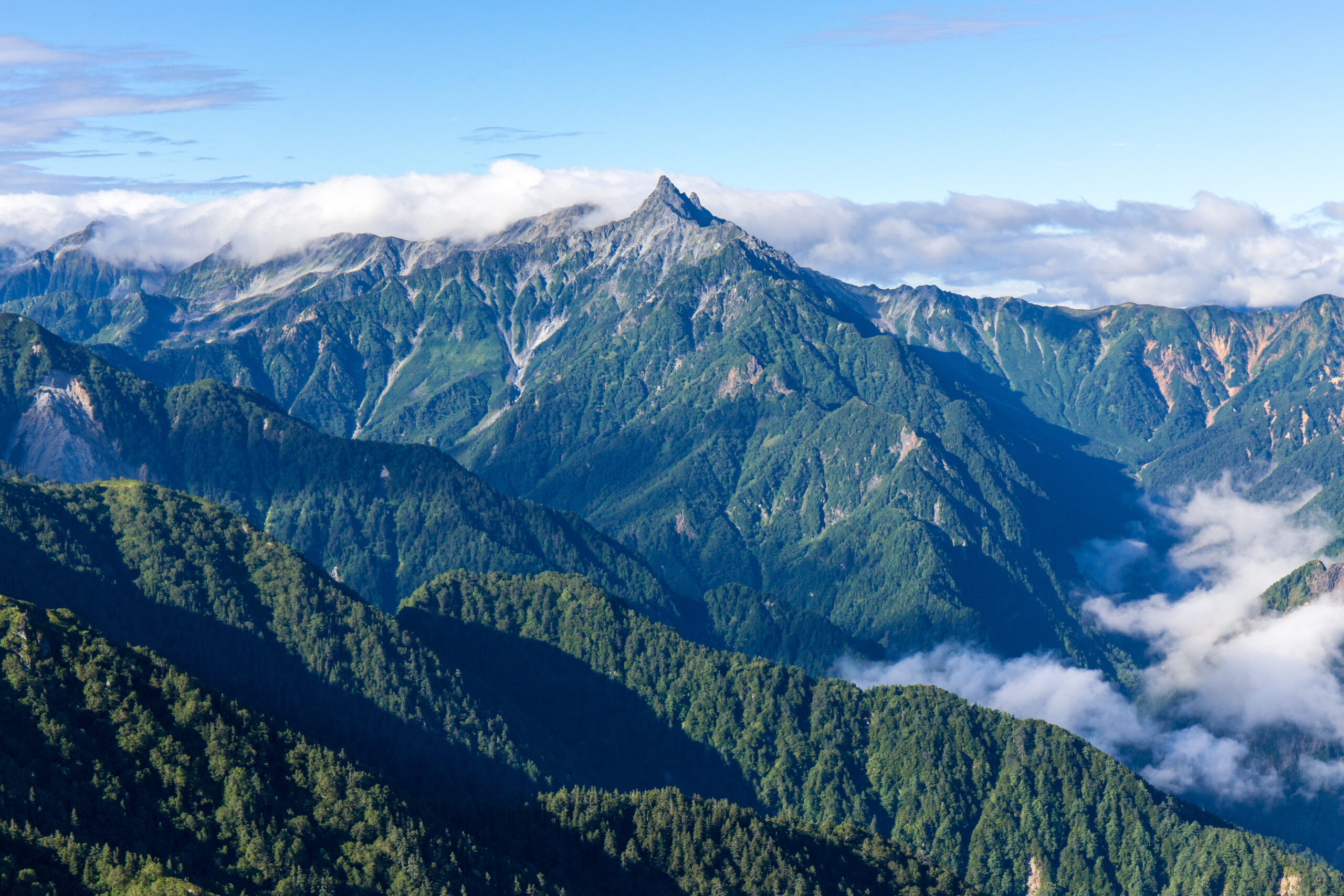
    Yarigatake, the spear-shaped summit of the Northern Japan Alps, the fifth-highest mountain in Japan
    Yarigatake is 3,180 m (10,433 ft), the fifth-highest mountain in Japan. Its spear-shaped summit, climbed on iron chains and ladders, is one of the country’s most beloved peaks.
    Expedition Updates · Japan

    Mount Yari expedition update

    The Matterhorn of Japan, a long hut-based hike with a sharp sting in the tail. This page tracks the routes, the chained summit block, the notorious Daikiretto, the huts and hiking-plan system, the season, and a go or no-go checklist. A single-mountain page in our Expedition Updates directory. Elevations in metres (feet).

    Current status Summer hut season 3,180 m (10,433 ft)

    The spear you climb on chains and ladders.

    Yarigatake is the fifth-highest mountain in Japan and one of its most loved, a sharp rock spear at the head of the Northern Alps. The normal route is a long, multi-day hut-based walk, but it ends with a short, steep, exposed scramble up the summit spire on fixed iron chains and near-vertical ladders. It is not a beginner mountain.

    There is no permit, but you should file a hiking plan, book huts ahead, and carry cash. And from Yari’s summit runs the Daikiretto, a knife-edge traverse to the Hotaka range that is one of the most dangerous trails in Japan. For the full route detail, see our Yarigatake guide.

    3,180 m

    Summit (10,433 ft)

    The fifth-highest mountain in Japan.

    Jul to Sep

    Main season

    Early August the sweet spot; huts run to late October.

    No permit

    File a hiking plan

    Hut-based and cash only; reserve ahead.

    Yarigatake stands in the Hida Mountains of the Northern Japan Alps, on the Nagano and Gifu border in Chubu-Sangaku National Park. Its name means spear peak, and the pyramid of rock at its summit has made it a rite of passage for Japanese climbers since the monk Banryu first climbed it in 1828. This page owns the current picture, the routes, the summit block, and the logistics. For the full history, day-by-day route detail, and gear, see our Yarigatake climb guide.

    Season and status

    A summer hut mountain, with a real early-season catch.

    The main season runs from July to September, with early August widely regarded as the sweet spot for stable afternoon weather and alpine wildflowers, and late September into October bringing the famous autumn colours. The huts open around the spring Golden Week holiday and close in late October, after which the route shuts to general hikers. The catch is early July, when the upper Yarisawa can still hold snow and ice, and an ice axe and crampons may be needed; Yarisawa Lodge has posted signs warning less-equipped hikers to turn back. Check current conditions before you commit to an early-season attempt.

    Why climbers love the spear

    The Matterhorn of Japan, and a rite of passage.

    Yarigatake earns its Matterhorn of Japan nickname from the clean rock spire that crowns it, visible from ridgelines across the range and instantly recognisable. For Japanese hikers it is one of the great aspirational peaks, a summit you work up to after easier mountains, and reaching the top of the spear on chains and ladders is a milestone in a climbing life. Walter Weston, the English missionary who helped bring alpinism to Japan, climbed and championed it, and it has anchored the culture of the Northern Alps ever since. The appeal is the combination: a long, beautiful valley and ridge walk, and a genuine bit of exposed climbing to finish.

    The routes and the summit block

    A long walk in, and a sharp climb out.

    The main ways up Yarigatake, all finishing with the chained summit block. Confirm current conditions before you go.
    RouteFromCharacterNotes
    Kamikochi / YarisawaKamikochiThe classic and most popular line, following the Azusa River up the Yarisawa gorge.About 39 km and 2,130 m of gain; two to four days.
    Omote-Ginza traverseNakabusa OnsenA spectacular high ridge over Tsubakuro and along the range to Yari.More committing; a multi-day traverse.
    Summit blockYarigatake SansoThe final 200 m of near-vertical rock on heavy iron chains and ladders.Short but steep and exposed; 20 to 30 minutes, with queues in season.
    DaikirettoToward HotakadakeA knife-edge traverse linking Yari to the Hotaka range, for experienced climbers only.One of the most dangerous stretches of trail in Japan.

    Most climbers take the Kamikochi and Yarisawa approach, a non-technical but long walk up the valley with one or more nights in huts before the summit push. Whatever the approach, the mountain saves its difficulty for the end: the final 200 m to the top is a near-vertical scramble on heavy iron chains and ladders, taking twenty to thirty minutes, with real exposure and, in season, queues both up and down. Wet or icy chains make it far more serious, so many climbers go for the summit at first light before the afternoon weather builds.

    The Daikiretto

    The knife-edge that starts where the easy climbing ends.

    âš  A separate mountain, and a far more dangerous one

    From Yari’s summit, a ridge runs south toward the Hotaka range and drops into the Daikiretto, a knife-edge traverse widely regarded as one of the most dangerous stretches of maintained trail in Japan. It is a long, highly exposed scramble on chains, ladders, and bolts, with sheer drops on both sides, and it would be graded a technical climb in many other countries. Climbers wear helmets, move deliberately, and pick settled weather.

    The Daikiretto is not part of the normal Yari ascent and should not be attempted on the strength of it. It is for experienced climbers with a head for extreme exposure only, and it is unforgiving of a slip or a lapse in concentration. This page is educational and is not a substitute for the skills the traverse demands.

    Huts, the hiking plan and access

    The logistics visitors most often get wrong.

    Yarigatake Sanso and the hut system

    Yarigatake Sanso, a large classic mountain hut just below the summit at around 3,000 m, is the usual base, providing dinner, breakfast, and a futon, with more huts along the approach such as Yarisawa Lodge. Budget roughly 10,000 to 15,000 yen a night with two meals, bring cash because the huts do not take cards, and reserve ahead in peak season. Designated tent sites are available at some huts for a small fee.

    No permit, but file a plan. Yarigatake needs no climbing permit or fee, but you should submit a hiking plan, a tozan-todoke, through the Nagano Police online system or an app such as Compass or Yamap, or on paper at the Kamikochi bus terminal, so rescuers know your route. Reach the mountain via Matsumoto and Kamikochi; private cars cannot enter Kamikochi, so park at Sawando or Hirayu and take the bus or a taxi in. Download offline maps, because phone signal is unreliable high on the mountain.

    Difficulty and altitude

    A serious hike with an exposed finish.

    Yarigatake is not a technical climb on its normal route, but it is a demanding one, with a long approach, a big height gain, an exposed chained summit at 3,180 m, and weather that turns quickly. It rewards real hill fitness and a head for heights rather than rope skills, and it sits well beyond a beginner day-hike. The altitude is enough to affect some hikers, so build the walk-in over a couple of days rather than racing up. Check your base against our fitness standards and gauge your altitude response with the AMS risk calculator.

    Weather and timing

    Fast-changing weather on an exposed summit.

    Weather at 3,180 m changes faster than many hikers expect, and the chained summit and the ridges become hazardous when wet or icy, so an early start and a settled forecast matter. The live map below shows current conditions; rely on a mountain forecast and the hut staff for the summit-day call.

    Live wind and weather for Yarigatake. Source: Windy.com. For how to read a mountain forecast, see our weather guide.
    Yarigatake, in the Northern Japan Alps on the Nagano-Gifu border, reached from Kamikochi. Map: OpenStreetMap contributors.

    Where Yari fits your progression

    A step up in the Japan Alps.

    Yarigatake is a mountain most Japanese hikers reach after building up on gentler peaks, and it makes a fine step beyond a walk-up like Mount Fuji into terrain with real exposure and hut-to-hut travel. From here the range opens up, whether along the ridges to the Hotaka peaks or, for the very experienced, across the Daikiretto itself. See the country’s most famous climb in our Mount Fuji expedition update, and weigh guiding against going alone in our guided versus independent climbing guide.

    Go or no-go checklist

    Work through these before you go.

    Before you go

    • File a hiking plan – submit a tozan-todoke online or on paper so rescuers know your route.
    • Book huts and carry cash – the huts fill in season and do not take cards.
    • Time the season – July to September, ideally early August; expect snow in the upper Yarisawa in early July.
    • Respect the summit block – the chains and ladders are exposed and dangerous when wet or icy.
    • Leave the Daikiretto alone unless expert – it is a separate, far more serious undertaking.
    • Download offline maps – phone signal is unreliable high on the mountain.

    Yarigatake update FAQ

    The questions climbers ask most about the summit block, the Daikiretto, and the huts.

    How hard is it to climb Mount Yari?

    Yarigatake is a long, demanding hike rather than a technical climb, but it is not a beginner mountain. The normal route is a multi-day approach, usually two to four days, with a big height gain to 3,180 m, and it finishes with a short, steep, exposed scramble up the summit spire on fixed iron chains and near-vertical ladders. Fit hikers with a head for heights can do it without ropes, though the chain sections become hazardous when wet or icy, and the summit block can bottleneck with queues in peak season.

    What is the Daikiretto?

    The Daikiretto is a notorious knife-edge ridge traverse linking Yarigatake to the Hotaka range, widely regarded as one of the most dangerous sections of maintained trail in Japan. It is a long, highly exposed scramble on chains, ladders, and bolts, with big drops on both sides, and it would be graded a technical climb in many countries. It is a separate and far harder undertaking than the normal Yari ascent, for experienced climbers with a helmet and steady nerves only.

    Do you need a permit or a guide for Yarigatake?

    There is no climbing permit and no fee, and no guide is required on the normal route, though guiding is available. Japan does ask climbers to file a hiking plan, called a tozan-todoke, which you can submit online through the Nagano Police system or apps like Compass and Yamap, or on paper at the Kamikochi bus terminal, so rescuers know your route if something goes wrong. Hut reservations are strongly advised in peak season.

    Which route should I take?

    The classic and most popular is the Kamikochi and Yarisawa valley approach, a long but non-technical walk-in that most hikers spread over two to four days with hut stays. The Omote-Ginza ridge traverse from Nakabusa Onsen is a spectacular multi-day alternative over the high ridgeline. Both finish with the chained summit block. Only experienced climbers should take on the Daikiretto to the Hotaka range.

    When is the Yarigatake climbing season?

    The main hiking season is July to September, with early August widely regarded as the sweet spot for stable weather and wildflowers, and late September into October bringing the famous autumn colours. The huts run from around the Golden Week holiday in spring until late October, and by November the route is closed to general hikers. Early July can still hold snow and ice in the upper Yarisawa, where an ice axe and crampons may be needed, so check conditions before you go.

    Where do you stay on Yarigatake?

    Yarigatake Sanso, a large classic mountain hut just below the summit at around 3,000 m, is the usual base, providing dinner, breakfast, and a futon; there are more huts along the approach, such as Yarisawa Lodge. Budget roughly 10,000 to 15,000 yen a night with two meals, and bring cash, because the huts do not take cards. Designated tent sites are available at some huts for a small fee. Book ahead in peak season, as the huts fill.

    How do you get to Yarigatake?

    The gateway is Kamikochi in the Northern Japan Alps, reached from Tokyo via Matsumoto by train, then a bus into the valley. Private cars cannot drive into Kamikochi, so you park at Sawando or Hirayu and take a bus or taxi in. From the Kamikochi bus terminal it is a long valley walk up the Azusa River and the Yarisawa gorge to the mountain.

    How high is Mount Yari and where is it?

    Yarigatake is 3,180 m (10,433 ft), the fifth-highest mountain in Japan, in the Hida Mountains of the Northern Japan Alps on the border of Nagano and Gifu prefectures. Its sharp, spear-like summit, which gives the mountain its name, spear peak, makes it one of the most recognisable and beloved mountains in the country. It was first climbed in 1828 by the Buddhist monk Banryu.

    📋 How this update is built

    This page is compiled by Travis Ludlow, Founder and Head of Research at Global Summit Guide, from Chubu-Sangaku National Park and Nagano Prefecture safety guidance, mountain-hut information, and the prefectural hiking-plan systems, with sources named below. It was reviewed for safety by Dawson Ludlow, our Climbing and Mountaineering Lead (Wilderness First Aid), whose highest first-hand summit is Kilimanjaro.

    Our team has not climbed Yarigatake, so we report official information and route records rather than personal experience, and we review this page for the summer hut season. Hut prices, transport, and conditions change, so confirm current details and file your hiking plan before you go.

    Planning a Yarigatake climb?

    Start with our Yarigatake guide for the full route detail, pair it with the country’s most famous climb in our Mount Fuji update, and choose a team in the operator directory. Most climbers stage through Tokyo and Matsumoto to Kamikochi, so for flights and lodging, browse travel on Expedia.

    Disclosure: the Expedia link above is a sponsored affiliate link. We may earn a commission at no extra cost to you.
    Was this helpful?

    Yes
    No
    Thanks for your feedback!
  • Mount Fuji Climbing 2026: Fees, Reservations, Season Dates & Trails

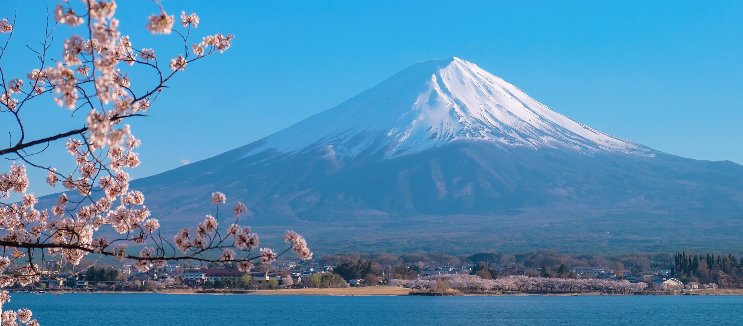
    Mount Fuji with snow-capped peak, framed by cherry blossoms in foreground, showcasing iconic Japan landscape during cherry blossom season.
    Mount Fuji is 3,776 m (12,388 ft), the highest mountain in Japan. In 2026 all four trails charge a 4,000-yen fee and require an advance online permit.
    Expedition Updates · Japan

    Mount Fuji climbing update

    The most-climbed big mountain in the world, and the rules changed again for 2026. This page tracks the 4,000-yen fee now on every trail, the two reservation systems, season dates by trail, the gate hours and bullet-climbing ban, and the four routes compared. A single-mountain page in our Expedition Updates directory. Elevations in metres (feet).

    Current status In season Jul to Sep 3,776 m (12,388 ft)

    More managed than the postcards. Your permit is now your trip plan.

    For 2026, every one of the four official trails charges a 4,000-yen fee and requires an advance online reservation that produces a QR-code permit. The Yoshida trail has a hard daily cap of 4,000 climbers, and gates close from 2 PM to 3 AM to anyone without a mountain hut booking.

    The season runs roughly July 1 to September 10, with the two Shizuoka trails opening July 10. Pick your date and trail, book the permit and a hut, and do it before you fly, because peak dates sell out.

    3,776 m

    Summit (12,388 ft)

    The highest mountain in Japan, and a UNESCO World Heritage site.

    4,000 yen

    Entry fee

    Mandatory on all four trails in 2026, booked online in advance.

    Jul to Sep

    Climbing season

    Roughly July 1 to September 10, when huts and buses run.

    Mount Fuji is not an expedition peak. It is a non-technical hike that around 200,000 people do every short summer, and its near-perfect cone is one of the most recognizable mountains on earth. What makes it worth a status page is how much the access rules have changed, and how much stale information is still circulating. This page covers the current 2026 picture: fees, reservations, season dates, the four trails, and the safety rules. For the history, the deeper route detail, and the evergreen how-to, see our Mount Fuji climb guide.

    What changed for 2026

    This is the first season the rules look the same across the whole mountain.

    Fuji’s access rules have tightened for three years running, in response to overtourism, litter, and unprepared hikers. The 2026 season is the point where those changes line up across all four trails. The headline is that the 4,000-yen fee, which started on the Yoshida trail, now applies to the three Shizuoka trails as well, and every route requires an online permit. If you read an older guide that says climbing Fuji is free, or that only the Yoshida side charges, or that you can simply turn up and walk, that information is out of date.

    The single most useful thing to know: on Fuji in 2026, your permit is your trip plan. Choose your date and trail, book and pay for the permit online, and lock a mountain hut if you want the sunrise, all before you leave home. Same-day slots are limited and the popular dates go early.

    Fees and reservations

    One fee, but two different booking systems depending on the trail.

    The fee is the same everywhere, but the way you book differs by side of the mountain, and this trips people up. The Yoshida trail, on the Yamanashi side, uses the prefecture’s online reservation system and enforces a daily cap of 4,000 climbers, so it can sell out on busy dates. The three Shizuoka trails, Subashiri, Fujinomiya, and Gotemba, use the FUJI NAVI smartphone app, which walks you through a short mandatory safety course before it issues your permit. Either way you end up with a QR code that becomes your entry pass at the trailhead.

    What a 2026 Mount Fuji climb costs, per person. Confirm current figures on the official climbing site before you book.
    ItemCostNotes
    Entry fee4,000 yen per personMandatory on all four trails in 2026, booked and paid online in advance.
    Mountain hut14,000 to 17,000 yen per personShared dorm space with dinner and a simple breakfast. Book well ahead.
    Shuttle busaround 3,900 yen round tripPrivate cars are banned on the 5th Station access roads in season.
    Cash on the mountainBring coins and notesHuts and toilets are cash only; withdraw yen before you leave the city.
    Book on the official site. Reserve and pay through the official Mount Fuji climbing site or the FUJI NAVI app, not a lookalike. A realistic all-in cost for an overnight climb, including transport, a hut, and meals, runs roughly 26,000 to 41,000 yen. Check your readiness against our fitness standards, and if altitude is new to you, our altitude-sickness risk calculator is worth a look.

    Season dates by trail

    A short window, and it is not the same date for every route.

    The official 2026 season has the Yoshida and Subashiri trails opening July 1 and the Fujinomiya and Gotemba trails opening July 10, with all four closing September 10. Subashiri moved earlier this year, to July 1, to line up with Yoshida. These dates can shift if late snow or poor conditions delay the opening, so treat them as scheduled rather than guaranteed and confirm before booking flights. The busiest stretch is the Japanese school holidays from late July through August, and the Obon week in mid-August is the peak of the peak.

    The four trails compared

    Which route suits which climber.

    Mount Fuji framed by cherry blossoms and a clear blue sky, iconic Japanese hiking destination.
    Fuji’s trails climb above the cloud line from the 5th Stations. The Yoshida route carries most of the traffic; the Shizuoka trails are quieter but less served by transport and huts.
    The four official Mount Fuji trails. Times are for the ascent and vary with fitness and crowds.
    TrailSide5th StationTime upCharacter
    YoshidaYamanashi (north)~2,300 m5 to 7 hrThe most popular by far, with the most huts and the best transport from Tokyo and Kawaguchiko. Daily cap of 4,000 climbers. The practical choice for a first climb despite the crowds.
    SubashiriShizuoka (east)~2,000 m5 to 7 hrQuieter, with a forested lower section, and it merges with the Yoshida trail high up. Opens July 1 in 2026, aligned with Yoshida.
    FujinomiyaShizuoka (south)~2,400 m4 to 6 hrThe shortest and steepest route, with the highest trailhead and the most direct line to the summit crater. Popular from the Shinkansen side.
    GotembaShizuoka (southeast)~1,400 m7 to 10 hrThe longest and hardest, with the lowest trailhead and the fewest huts. The route for fit, experienced hikers who want solitude.
    For most first-timers, Yoshida is the practical pick. It has the most huts, the best transport from Tokyo and Kawaguchiko, and clear signage, which matters on a busy overnight climb. If you want solitude and have the fitness, Gotemba delivers it at the cost of a much longer day. Compare the routes in depth in our Fuji trails guide.

    Gate hours and bullet climbing

    The rule that most changes how you plan the climb.

    Trailhead gates are open from 3 AM to 2 PM. Between 2 PM and 3 AM, entry is restricted to climbers who hold a mountain hut reservation. The target is bullet climbing, the practice of racing up and down through the night without resting, which leaves people exhausted, cold, and prone to altitude illness and accidents near the summit in the dark. The rule effectively means that if you want to be on the summit for sunrise, the safe and now the required way to do it is to climb partway, sleep in a hut, and finish in the early morning.

    Altitude and safety

    The most underestimated mountain in this directory.

    âš  A hike, but a serious one

    At 3,776 m, Mount Fuji is high enough that altitude sickness is common, and people regularly underestimate it because it is a walk rather than a climb. Headache, nausea, and dizziness are frequent, and the summit can be cold, wet, and fiercely windy even in midsummer, when the valley below is hot.

    Climb at a slow, steady pace, spend time acclimatizing at the 5th Station and a hut rather than rushing up, carry warm and waterproof layers and proper footwear, and turn around if altitude symptoms worsen. Our acclimatization guide covers the physiology. This page is educational and is not medical advice.

    Huts and the sunrise

    The goraiko, and why the hut booking is the linchpin.

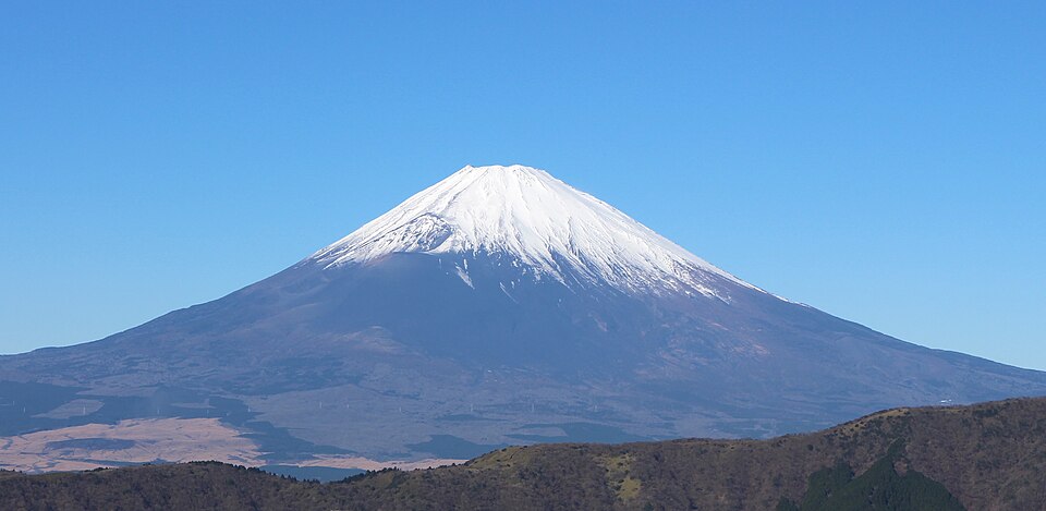
    Mount Fuji with snow-capped peak against a clear blue sky, representing a prominent climbing destination in Japan.
    The goraiko, the sunrise seen from high on Fuji above a sea of cloud, is the reason most climbers go. Only a portion of climbers get a clear one, so treat it as a bonus rather than a guarantee.

    Mountain huts sit at intervals up all four trails, offering a shared dorm space, dinner, and a simple breakfast, usually for 14,000 to 17,000 yen a person. They are basic and crowded at peak times, and wake-up calls come as early as 1:30 AM so climbers can reach the summit for the sunrise, known as the goraiko. Booking a hut is close to essential in 2026: it is what lets you climb through the restricted overnight hours, and it turns a punishing single push into a paced, safer two-day trip. Reserve early, because the best dates around Obon sell out well ahead.

    Weather and timing

    A live look at conditions on the cone.

    Fuji’s weather changes fast, and the summit can be in cloud, rain, or strong wind while the base is clear and warm. Only a portion of climbers get a clear sunrise on any given morning. The live map below shows current conditions; use it as background and rely on the hut staff and the official forecast on the day for the real picture.

    Live wind and weather for Mount Fuji. Source: Windy.com. For how to read a mountain forecast, see our weather guide.
    Mount Fuji, on the Yamanashi and Shizuoka border, about 100 km southwest of Tokyo. Map: OpenStreetMap contributors.

    Know before you go

    The 2026 essentials in one place.

    Before you climb

    • Book the permit online first – all four trails require it; Yoshida via the Yamanashi system, the Shizuoka trails via the FUJI NAVI app.
    • Reserve a mountain hut – it is what lets you climb the overnight hours for the sunrise, and it makes the climb safer.
    • Pick your date off-peak if you can – avoid Obon in mid-August and weekends, when the Yoshida cap and crowds bite.
    • Carry cash – huts and toilets are cash only; bring yen and 100-yen coins.
    • Pack for cold and wet – waterproof layers, warm clothing, and proper footwear, whatever the forecast in the city.
    • Respect the altitude – pace slowly, acclimatize, and turn back if symptoms worsen.

    Mount Fuji update FAQ

    The questions climbers ask most about fees, reservations, and the season.

    How much does it cost to climb Mount Fuji in 2026?

    The mandatory entry fee is 4,000 yen per person, and in 2026 it applies to all four official trails, not just the Yoshida route. Once you add transport to the 5th Station, a mountain hut, meals, and any gear, a realistic all-in figure for an overnight climb runs roughly 26,000 to 41,000 yen, about 175 to 275 US dollars. The fee is paid online when you reserve, and huts and toilets on the mountain are cash only.

    Do I need a reservation to climb Mount Fuji?

    Yes. In 2026 all four trails require advance online registration and payment, which produces a QR-code permit you show at the trailhead. The Yoshida trail uses Yamanashi Prefecture’s booking system and has a daily cap of 4,000 climbers, so it can sell out on peak dates. The three Shizuoka trails, Subashiri, Fujinomiya, and Gotemba, use the FUJI NAVI app, which includes a short mandatory safety course before it issues your permit.

    When is the 2026 Mount Fuji climbing season?

    The Yoshida and Subashiri trails are scheduled to open July 1 and the Fujinomiya and Gotemba trails July 10, with all four closing September 10. Subashiri moved earlier to July 1 this year to align with Yoshida. Opening dates can shift if snow, weather, or trail conditions require, so confirm before you lock in flights. Climbing outside this window is strongly discouraged, because the huts close and transport stops.

    What are the gate hours, and what is bullet climbing?

    Trailhead gates are open from 3 AM to 2 PM. Entry between 2 PM and 3 AM is restricted to climbers who hold a mountain hut reservation. This targets bullet climbing, the practice of racing up and down overnight without resting in a hut, which leads to exhaustion, altitude illness, and accidents. To climb overnight for the sunrise, you need a hut booking, which is also the safer way to do it.

    Which Mount Fuji trail should I choose?

    For a first climb, the Yoshida trail is the practical pick, with the most huts, the best transport from Tokyo, and clear signage, though it is the busiest. Fujinomiya is the shortest and steepest and starts highest. Gotemba is the longest and hardest, with the fewest huts and the most solitude, suited to fit and experienced hikers. Subashiri is quieter and joins Yoshida high on the mountain.

    How hard is Mount Fuji, and do I need experience?

    It is a non-technical hike, but a serious one that people underestimate. At 3,776 m the altitude is real, and altitude sickness is common, the day is long, and the summit can be cold, wet, and windy even in midsummer. You do not need technical climbing skills, but you do need reasonable fitness, proper footwear, warm and waterproof layers, and a sensible pace. It is not a casual walk.

    Can I climb Mount Fuji outside the official season?

    It is strongly discouraged. Outside roughly July to early September the mountain huts are closed, the shuttle buses do not run, and there is snow and severe cold high up, which turns a manageable hike into a mountaineering undertaking with a real risk of serious accidents. The rules, staffing, and rescue support are all built around the official summer window.

    How high is Mount Fuji and where is it?

    Mount Fuji is 3,776 m (12,388 ft), the highest mountain in Japan and a UNESCO World Heritage cultural site. It straddles the border of Yamanashi and Shizuoka prefectures, about 100 km southwest of Tokyo, and its near-perfect cone is climbed by roughly 200,000 people each short summer season.

    📋 How this update is built

    This page is compiled by Travis Ludlow, Founder and Head of Research at Global Summit Guide, from the official Mount Fuji climbing site, the Yamanashi and Shizuoka prefectural rules, and current-season guidance, with sources named below. It was reviewed for safety by Dawson Ludlow, our Climbing and Mountaineering Lead (Wilderness First Aid), whose highest first-hand summit is Kilimanjaro.

    Our team has not climbed Mount Fuji, so we report official rules and published guidance rather than personal experience, and we review this page through the summer season. Fuji’s rules have changed every year lately, so treat the figures here as current at the time of writing and confirm fees, dates, and reservation steps on the official site before you travel.

    Planning a Fuji climb?

    Start with our Mount Fuji climb guide for the full how-to, check the timing in our best time to climb Fuji guide, and see where it fits for newer climbers in our best beginner mountains roundup. For flights and lodging around the Fuji Five Lakes and Tokyo, browse travel on Expedia.

    Disclosure: the Expedia link above is a sponsored affiliate link. We may earn a commission at no extra cost to you.
    Was this helpful?

    Yes
    No
    Thanks for your feedback!
Language »