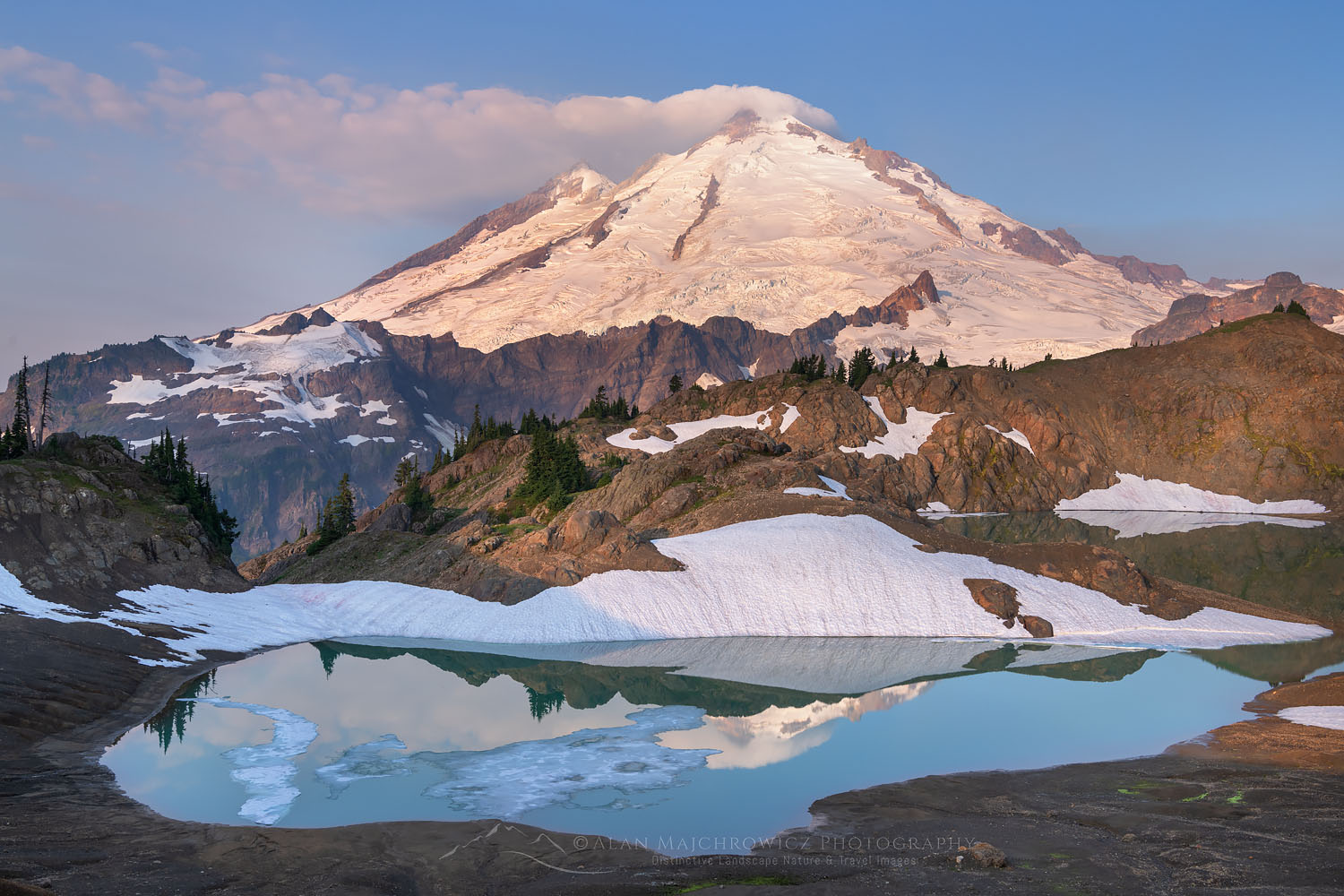
Mount Shuksan: the most photographed peak that climbs like a mountain
Shuksan is one of the most photographed mountains in the world, its reflection in Picture Lake a Cascades icon. Behind the postcard is a serious alpine climb: a non-volcanic, heavily glaciated horn beside the volcano Baker, where every route finishes with a rock climb up the summit pyramid. This update covers the Sulphide Glacier, the classics, permits, and an honest readiness view. Heights in feet (metres).
Updated 27 July 2026 · Compiled by Travis Ludlow · Safety review by Dawson Ludlow · Medical review by Taylor Ludlow, RN
Single-mountain expedition update, compiled from National Park Service information, guide-service route descriptions, and published climbing records. Our team has not climbed Mount Shuksan; the only first-hand summit anyone on our team claims is Kilimanjaro. This is a planning briefing for climbers with alpine skills, not a how-to and not a substitute for training or a guide.
A postcard from the outside, an alpine climb up close.
Shuksan is admired by millions from the roadside at Picture Lake, and climbed by far fewer. It is not a volcano like its neighbour Baker but a glacier-carved rock horn, and its every route ends with a rock climb up the summit pyramid. Even the moderate Sulphide Glacier demands glacier travel, crevasse rescue, and exposed Class 3 to 4 rock. It is a superb step up from a volcano walk-up toward real alpine climbing.
- One of the most photographed peaks on Earth.
- Non-volcanic, glaciated rock horn beside Baker.
- Every route finishes on the summit pyramid.
- Standard route: the Sulphide Glacier.
- Glacier plus rock skills required, not a hike.
On this page
What Shuksan involves
An accessible but genuine alpine climb: a glacier, a rock pyramid, and Cascade weather, all in a short, committing package.
Mount Shuksan rises to 9,131 ft in the North Cascades of Washington, a heavily glaciated, non-volcanic peak within North Cascades National Park, beside the volcano Mount Baker. Where Baker is a rounded ice-clad volcano, Shuksan is a craggy horn of rock, wrapped in glaciers and topped by a distinct rock pyramid. That structure is what makes it so photogenic, and what makes it a real climb rather than a walk.
The standard Sulphide Glacier route begins with a forest approach to a high camp, then an alpine start across the glacier to the base of the summit pyramid, where climbers swap crampons for a Class 3 to 4 rock scramble to the top. It is very achievable for competent alpine climbers, and a fine objective for those building skills, but it asks for glacier travel, crevasse rescue, and comfort on exposed rock. Build those first with glacier travel basics and crevasse rescue basics.
The postcard, and the pyramid
The same features that make Shuksan the most photographed peak in the Cascades are what make it a serious summit.
Shuksan’s fame is built on one view: its reflection in Picture Lake, off the Mount Baker Highway, a scene printed on countless calendars and postcards. The steep glaciers dropping off its north side, the layered rock, and the sharp summit give it a drama that few peaks match, and draw photographers in every season. Most who admire it never set foot above the meadows.
Those who climb it meet a different mountain. Whatever route reaches the base of the summit pyramid, the top itself is a rock tower, roughly 500 to 600 ft of Class 3 to 4 climbing, or steep snow in early season. It is the crux of every ascent, exposed and committing, and if the rock is glazed with ice, the right decision is to turn around below it. The postcard and the pyramid are the same mountain, seen from two very different places.
Icy rock is a turnaround
The summit pyramid is unavoidable, and it is dangerous when iced. If conditions coat the rock, a strong team accepts a high point below the summit rather than forcing it. The mountain will still be photogenic next season.

The most photographed peak in the Cascades
From Picture Lake to Artist Point, Shuksan anchors some of the most famous views in the Pacific Northwest. Its cascading glaciers and layered rock are a photographer’s gift, and a climber’s challenge. The same relief that fills the frame is the relief you climb to reach its rocky summit.
Are you ready for Shuksan?
Shuksan rewards climbers who bring two skill sets, glacier and rock, and the judgment to read the weather. These are the prerequisites.
Rope, Axe, Crampons
Even the standard route crosses a real glacier. Roped travel and crevasse rescue are prerequisites, not extras.
Evidence: prior glaciated climbs.The Summit Pyramid
Every route tops out on 500 to 600 ft of exposed Class 3 to 4 rock. You must be comfortable moving on it.
Evidence: prior exposed alpine rock.Cascade Conditions
North Cascades weather turns fast. Reading it, and knowing when the pyramid is too icy, is a safety skill.
Evidence: sound calls in changeable weather.Ice Means Stop
If the summit rock is coated in ice, the safe answer is to descend. Ego is the real hazard here.
Evidence: willingness to turn back.| Requirement | Baseline | Why it matters |
|---|---|---|
| Glacier competence | Roped travel and crevasse rescue | The Sulphide and other routes cross live glaciers. |
| Alpine rock | Comfortable on Class 3-4 exposure | The summit pyramid is unavoidable on every route. |
| Fitness | Strong for a long approach and summit day | A forest approach plus a big summit day, back to back. |
| Weather sense | Able to read fast Cascade changes | Conditions and the pyramid’s state shift quickly. |
| Permits | North Cascades wilderness permit | Overnight trips need a park permit; access is limited. |
| Judgment | Willing to turn around | Icy summit rock is a clear stop signal. |
If you are coming from a volcano like Mount Baker, Shuksan is a natural next step that adds real rock to your glacier skills.
The Sulphide, and the classics
One moderate standard route, and two celebrated harder lines. All of them finish on the same summit pyramid.
Sulphide Glacier
The most popular and moderate line, from the south, and the route of the 1906 first ascent. It crosses the Sulphide Glacier to the base of the summit pyramid, then climbs a Class 3 to 4 gully to the top. It is an excellent introduction to North Cascades alpine climbing, but it is still a glacier climb with a real rock finish.
- Moderate glacier travel from the south
- Class 3-4 summit-pyramid gully
- The 1906 first-ascent line
- A fine step up to alpine climbing
Fisher Chimneys and the North Face
The Fisher Chimneys, from the north, is a celebrated North Cascades classic, demanding rock, steep snow, and route-finding through the chimneys, Winnie’s Slide, and Hell’s Highway before the pyramid. The North Face is a serious ice and alpine climb. Both are steps beyond the Sulphide in commitment and skill.
- Fisher Chimneys: a North Cascades classic
- Rock, steep snow, and route-finding
- North Face: a serious ice line
- For experienced alpine climbers
| Factor | Sulphide Glacier | Fisher Chimneys / North Face |
|---|---|---|
| Side | South | North |
| Character | Moderate glacier plus rock finish | Rock, steep snow, ice, route-finding |
| Grade feel | An intro to Cascade alpine | A North Cascades classic and beyond |
| Summit | The pyramid gully | The pyramid, via a harder approach |
| Who it suits | Competent glacier climbers | Experienced alpinists |
For the volcano beside it, see our Mount Baker update; for the range’s giant, our Mount Rainier update.
The Sulphide Glacier, step by step
An overview of the standard route, from the trailhead to the summit pyramid and back.
Bellingham / Seattle
The cities and the Mount Baker Highway that lead to the trailheads.
Shannon Ridge or Lake Ann
Sulphide Glacier from the south; Fisher Chimneys from the north.
Old-growth And Meadows
A several-mile hike through forest and alpine meadow to camp.
Glacier’s Edge
Camp near the toe of the glacier, below the upper route.
Sulphide Crossing
An alpine start and a roped crossing of the glacier at dawn.
Crampons Off
The glacier ends at the foot of the summit pyramid.
The Rock Finish
500 to 600 ft of Class 3 to 4 rock, or steep snow early season.
Down The Route
Reverse the pyramid and the glacier back to camp and out.
The pyramid is the point
The glacier gets you to the base; the summit pyramid gets you to the top. Save energy and time for that final rock, check its condition before committing, and treat it as the real climb it is.
A Shuksan climb timeline
Shuksan is usually a two to three-day climb: a forest approach, a night at high camp, and a big summit day on glacier and rock.
Travel to the trailhead
Drive from Seattle or Bellingham to the Sulphide or Fisher Chimneys trailhead.
Hike in through the forest
Climb through old-growth forest and alpine meadow to a high camp.
Review skills at camp
Refresh glacier travel and rope work, and prepare for an alpine start.
Alpine start on the glacier
Leave before dawn and cross the glacier toward the summit pyramid.
Climb the summit pyramid
Swap to rock and climb the Class 3 to 4 pyramid to the true summit.
Descend to camp
Reverse the pyramid and glacier carefully back to high camp.
Pack out
Hike back down through the forest to the trailhead.
Cost, permits and access
Shuksan is an affordable, short guided climb by big-mountain standards, but it does need a park permit and comes with limited peak-season access.
| Component | Figure | Note |
|---|---|---|
| Guided climb | Two to three days | A short guided program, often two to three days on Shuksan. |
| Wilderness permit | North Cascades NP | Required for overnight trips; limited in peak season. |
| Trailhead access | National forest roads | Forest-road driving to the Sulphide or Fisher trailheads. |
| Personal gear | Glacier and rock kit | Crampons, axe, harness, helmet, and rock protection as needed. |
| Skills | Glacier and rock | The skills to climb a glacier and exposed alpine rock. |
Plan the permit early
The summit, route, and camps sit within North Cascades National Park, so overnight trips need a wilderness permit, and access to popular North Cascades zones is limited in peak season. Sort this early, and confirm the current rules with the park, because it can be the deciding factor in when, and whether, you climb.
Choosing a Shuksan guide
Several North Cascades guide services climb Shuksan, often as a skills-and-summit program. These are the questions worth asking.
Sulphide Or Fisher
Which route suits your skills, from moderate glacier to classic chimneys.
Tighter On The Pyramid
The summit rock calls for a low guide-to-client ratio.
Pyramid State
Ask about the current state of the summit rock and glacier.
Handled In Advance
A good operator sorts the North Cascades permits and access.
Learn As You Climb
Many programs teach glacier and rock skills along the way.
Flexible Dates
Cascade weather means a plan that can move or wait.
How to choose an expedition operator covers the vetting, and the operator directory is a place to start.

Glacier below, rock above
Shuksan asks for two mountaineers in one: the glacier traveller who crosses the Sulphide roped and watchful, and the rock climber who takes the sharp end on the summit pyramid. That combination, in a compact and beautiful package, is exactly why it is such a rewarding step in a climber’s progression.
Difficulty and hazard, honestly
Shuksan is accessible, but not casual. Its hazards are the glacier, the rock pyramid, and the speed of Cascade weather.
| Hazard | What it is | How to treat it |
|---|---|---|
| The summit pyramid | Exposed alpine rock | Unavoidable Class 3-4; icy rock is a turnaround. |
| Crevasses | Live glaciers | The Sulphide and other glaciers require roped travel. |
| Fast weather | Cascade changeability | Storms and cloud arrive quickly; the pyramid can ice up. |
| Route-finding | Especially Fisher Chimneys | Complex terrain rewards navigation and experience. |
Season and weather
Summer is the season for the rock summit pyramid; early season means steep snow, and Cascade weather decides the rest.
Prime
The summit pyramid is workable rock; the classic window.
Good
Often stable and quiet, into early autumn.
Steep Snow
The pyramid holds steep snow rather than clean rock.
Ice And Alpine
The North Face and ice lines, for experts only.
Weather Rules
Cascade conditions decide far more than the calendar.
A short history of Shuksan
From a 1906 first ascent to a place on the world’s most photographed lists.
Mount Shuksan was first climbed, by the accepted record, on 7 September 1906 by Asahel Curtis and W. Montelius Price, by the Sulphide Glacier, though an earlier ascent in 1897 has been claimed. Several of the mountain’s glaciers carry the names of those early climbers. The name Shuksan itself comes from a Lummi word meaning high peak, and the mountain has been a landmark to the peoples of the North Cascades far longer than it has been climbed.
In the modern era, Shuksan became one of the most photographed mountains anywhere, its image tied to the Mount Baker area and the view across Picture Lake. For climbers it has stayed a beloved objective, valued precisely because it pairs an approachable glacier with a genuine rock summit, a mountain that looks like a poster and climbs like the real thing.
The Cascades cluster
Shuksan sits among the great Cascade peaks, with the glacier and rock skills that a North Cascades climb demands.
Mount Baker
The glaciated stratovolcano beside Shuksan, and a gentler glacier climb.
Read the update ->The Cascade giantMount Rainier
The biggest glaciated volcano in the range, a major objective.
Read the update ->Oregon’s volcanoMount Hood
A popular, and underestimated, Cascade volcano to the south.
Read the update ->Core skillGlacier travel basics
The roped-glacier skills the Sulphide route demands.
Learn the skill ->Mount Baker expedition update
The volcano next door and a natural pairing.
->Crevasse rescue basics
Essential practice for Shuksan’s glaciers.
->Glacier travel basics
Roped travel for the Sulphide and beyond.
->Mountaineering fitness standards
Preparing for the approach and summit day.
->Mountain weather for climbers
Reading fast-changing Cascade conditions.
->Mountaineering insurance
Rescue and evacuation cover for alpine climbs.
->Back to the full Expedition Updates dashboard for every mountain we track.
Where Shuksan fits
The Cascade peaks, and the contrast between a volcano and a glaciated rock horn.
Mount Shuksan FAQ
The questions climbers ask most about the difficulty, the summit pyramid, the permits, and the season.
How high is Mount Shuksan, and where is it?
Mount Shuksan is 9,131 ft (2,783 m), in the North Cascades of Washington, within North Cascades National Park and beside the Mount Baker scenic area. It is one of the highest peaks in the state, though not the tallest, and sits about 11 miles from the Canadian border. Its name comes from a Lummi word meaning high peak.
Is Shuksan a volcano like Mount Baker?
No, and that is part of what makes it distinctive. Its neighbour Mount Baker is a stratovolcano, but Shuksan is a non-volcanic peak, a glacially carved horn of metamorphic rock draped in glaciers. That structure gives it steep rock faces and cascading icefall glaciers, and the craggy, layered look that makes it so photogenic.
Why is Shuksan so famous in photos?
It is often called one of the most photographed mountains in the world. Its reflection in Picture Lake, in the Heather Meadows area off the Mount Baker Highway, is a Pacific Northwest icon, and the peak’s dramatic relief and glaciers draw photographers year-round. The postcard, though, hides a serious climb.
Is Shuksan a hike or a real climb?
A real climb. Even the standard Sulphide Glacier route requires glacier travel, crevasse-rescue skill, and a Class 3 to 4 rock scramble up the summit pyramid, and every other route is harder. It is not a walk-up, and it is a common step up for climbers moving from a volcano like Baker toward technical alpine terrain.
What is the summit pyramid?
The summit pyramid is the final rock tower that tops every route on Shuksan, roughly 500 to 600 ft of climbing on alpine rock, or steep snow in early season. On the standard route it is climbed by a Class 3 to 4 gully; if it is coated in ice, the safe choice is to turn around. Reaching the true summit means climbing this pyramid, whatever route you took to its base.
What are the main routes?
The Sulphide Glacier, from the south, is the standard and most popular line, a moderate glacier climb finishing on the summit-pyramid gully, and the route of the 1906 first ascent. The Fisher Chimneys, from the north, is a celebrated North Cascades classic that demands rock, steep snow, and route-finding skill. The North Face is a serious ice and alpine objective for experienced climbers.
When is the season, and do I need a permit?
The main climbing season is roughly July to September, when the summit pyramid is workable rock; early season means steep snow instead. Because the summit, route, and camps lie within North Cascades National Park, a wilderness permit is required for overnight trips, and access to popular North Cascades zones is limited in peak season. Confirm current permit rules with the park before you go.
What experience do you need?
Solid glacier travel and crevasse-rescue skills, comfort on exposed Class 3 to 4 alpine rock, and the judgment to read fast-changing Cascade weather. Shuksan is very achievable for competent alpine climbers and a superb objective for those building technical skills, but it is more than a fit hiker should take on unroped or unpracticed.
How we built this update
What this page is based on, who reviewed it, and what we do not claim to know.
Sources
- National Park Service information for North Cascades access and permits.
- Guide-service route descriptions for the Sulphide Glacier and Fisher Chimneys.
- Published climbing records for the routes, grades, and 1906 first ascent.
- Glacier and geography references for the mountain’s non-volcanic structure.
- Our own glacier travel and crevasse rescue guides for the core skills.
Review and standards
Compiled by Travis Ludlow and reviewed for safety by Dawson Ludlow, our Climbing and Mountaineering Lead (Wilderness First Aid), whose highest first-hand summit is Kilimanjaro. Health and medical points were reviewed by Taylor Ludlow, RN. We do not fabricate summit experience, quotes, or credentials, and we say plainly when we are reporting rather than recounting.
What we do not claim to know
Conditions on Shuksan change through the season, and no web page can replace current route reports and a guide’s judgment. In particular:
- The summit pyramid’s state, rock or snow or ice, varies week to week.
- Permit rules and North Cascades access limits change; confirm with the park.
- Glacier conditions shift with the season and the year.
- Our team has not climbed Shuksan, so we report records and route descriptions, not personal experience.

Global Summit Guide research
We compile mountain updates from park information, guide route descriptions, and published records, review them for safety and medical accuracy, and refresh them each season. We are transparent about what we have and have not climbed, and Shuksan is a research-based briefing, not a personal account.
About our team and standards ->Come for the postcard. Respect the pyramid.
Build the foundation with our glacier travel and crevasse rescue guides, pair Shuksan with the volcano next door in our Mount Baker update, and weigh yourself against our fitness standards. Trips stage through Bellingham and Seattle, so for flights and lodging, browse travel on Expedia.
Disclosure: the Expedia link above is a sponsored affiliate link, and we may earn a commission at no extra cost to you. It is the only affiliate link on this page; our route, permit, and safety guidance is independent.