
Kings Peak via Henrys Fork: our 3-day backpack to Utah’s highest summit
If you live in Utah and you are serious about mountains, Kings Peak is the rite of passage. At 13,528 feet it is the state high point, it is non-technical, and the Henrys Fork approach is the cleanest route in. We had done bigger peaks (Aconcagua, Kilimanjaro) but had somehow never climbed our own state’s high point until late August 2023. Three days, 29 miles, one boulder field that lasts an hour and a half, and a summit ridge with views all the way into Wyoming. This is the unedited trip report. What worked, what we underestimated, and what we would do differently next time we drove the 3 hours up from Salt Lake. The full peak-by-peak progression framework that this trip slots into lives in our master mountaineering hub.
The route at a glance
Kings Peak sits at the eastern edge of the Uinta Mountains in the High Uintas Wilderness of northeastern Utah. The Uintas are the only east-west running major mountain range in the lower 48, a strange geographic detail that becomes obvious once you are standing on Anderson Pass looking down into both Painter Basin (south) and Henrys Fork Basin (north). The mountain is approached from three sides: Henrys Fork from the north (the most popular), Yellowstone Creek from the south (longer, less traveled), and the Uinta River drainage from the southeast (rarely used). Henrys Fork is the standard route because it is the shortest at 29 miles round trip and the trailhead at 9,400 feet starts you within reach of a single backpacking day to Dollar Lake.
The trailhead is in Wyoming, which surprises first-time visitors. You drive 3 hours from Salt Lake City east on I-80 across the state line, exit at Lyman, drop south through Mountain View on Wyoming 410, and then follow the dirt Forest Road 17 for the final 15 miles to the Henrys Fork Trailhead in the Ashley National Forest. No fees, no permits, just a self-registration kiosk at the trailhead. From there, the trail follows Henrys Fork creek upstream through forest and meadow for 8 miles to Dollar Lake at roughly 10,800 feet, then continues another 4 miles climbing through Gunsight Pass into Painter Basin and up to Anderson Pass at 12,800 feet. From Anderson Pass, the summit ridge runs 1.5 miles of class 2 boulder hopping to the 13,528-foot summit.
Phase 1: the drive and the trailhead (Day 0)
Salt Lake City to Henrys Fork Trailhead
We left Salt Lake at 2 PM on Friday and rolled into the Henrys Fork Trailhead campground around 5:30 PM. The drive is straightforward until the last 15 miles, which run on dirt Forest Road 17 from Mountain View, Wyoming. The road is passable by any car in dry conditions but becomes hard work after rain. There is no cell signal from Mountain View onward, so download offline maps before you leave.
The trailhead has a small campground with vault toilets and primitive sites scattered along the access road. Cost is around $10 per night per site. We grabbed a spot, set up the tent, and ate a quick dinner at the truck. The mosquitoes were thick at the trailhead in late August (this was a wet year), and we burned through more bug spray in 30 minutes at the trailhead than we did the entire rest of the trip above tree line. Recommendation: pack permethrin-treated layers if you are going during peak mosquito season, which in the Uintas is roughly mid-July through mid-August.
Phase 2: backpacking in to Dollar Lake (Day 1)
Henrys Fork Trailhead to Dollar Lake
We started hiking at 8 AM. The first 3 miles climb gently through lodgepole pine forest along Henrys Fork creek, gaining about 600 feet to Elkhorn Crossing. The trail crosses the creek twice in the first 4 miles. In late August the water level was low enough to rock-hop both crossings without changing footwear. In early summer (June and early July), expect to wade or use stepping logs that are often submerged. The trail is well-maintained, well-marked, and easy to follow.
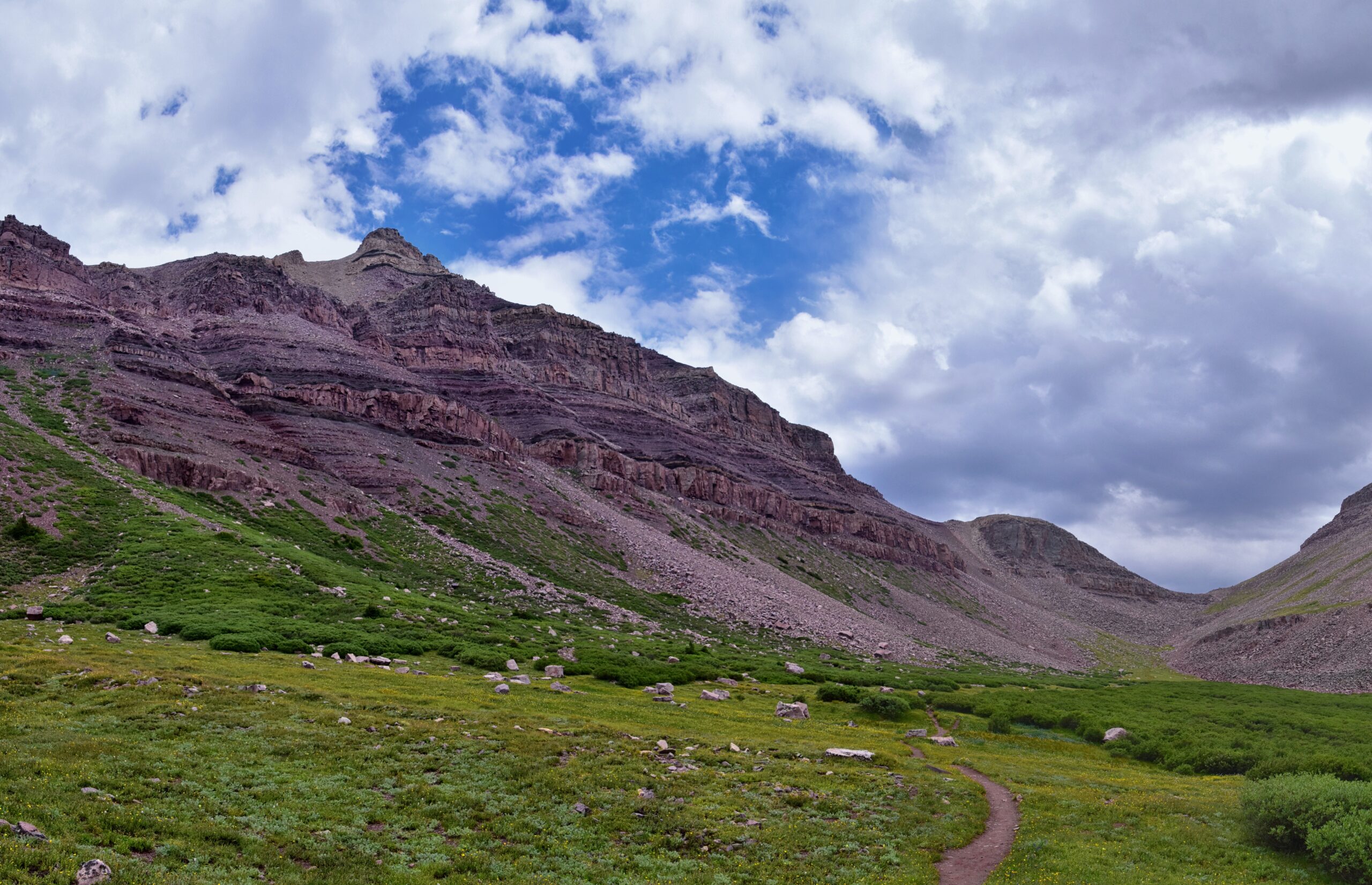
Past Elkhorn Crossing the forest opens into the broad Henrys Fork meadows. This is the visual payoff of the approach: the upper Uinta basin stretching south, the cathedral walls of Henrys Fork Peak on the right (the rounded high mountain that frames the basin), and Kings Peak itself visible far to the south as a dark, blocky summit. Dollar Lake sits at about 8 miles in, roughly 10,800 feet, on a small bench just east of the main trail. Most people camp here. Some push 1 to 2 miles further to Henrys Fork Lake at 10,900 feet for a shorter summit-day approach. We chose Dollar Lake for the views. The backpacking kit that makes a trip like this work is detailed in our expedition pack guide, our layering systems article, our trekking poles guide, and the broader gear context in our crampons and ice axes guide for the snow conditions that linger early season.
We had been climbing for six hours, complaining the whole time about pack weight. Then we crested the small ridge above the lake, and Kings Peak was sitting right there at the south end of the basin, perfectly framed between the ridgelines. Suddenly nobody was complaining anymore.
Camp setup at Dollar Lake means following standard High Uintas Wilderness regulations: camp at least 200 feet from water, no campfires above 10,800 feet (Dollar Lake is right at that line, so practically no fires), and pack out all waste including used toilet paper. The mosquito situation was much better than at the trailhead. The afternoon thunderstorms missed us, but we could see lightning on the ridges to the east starting around 4 PM. We ate dinner early, did our gear prep for summit day, and were asleep by 9 PM.
Phase 3: summit day (Day 2)
Dollar Lake to Kings Peak summit and return
We left camp at 5:00 AM in headlamp light. The summit day timing is the single most important decision of the trip: be off the exposed summit ridge before 1:00 PM, when the standard Uinta afternoon thunderstorms start firing. We aimed for a 10 AM summit, which gave us 3 hours of buffer to be back below Anderson Pass before the lightning risk built up. Some groups push for a 9 AM summit. Either works. A noon summit attempt is asking for trouble.
The trail from Dollar Lake climbs gradually through Henrys Fork Basin for the first 2 miles to Henrys Fork Lake (10,900 feet). From there it steepens toward Gunsight Pass at 11,888 feet. The view from Gunsight Pass is one of the highlights of the whole trip: looking south into Painter Basin and the upper Uinta drainage with Kings Peak rising at the southwest corner. The boulder field on the summit ridge is visible from here, which is sobering. From Gunsight Pass, the trail drops 300 feet into the basin then climbs steadily for the next 1.5 miles to Anderson Pass at 12,800 feet.
Anderson Pass is where the trail ends and the route begins. The summit ridge runs 1.5 miles roughly west to the Kings Peak summit, all of it class 2 boulder hopping over car-sized blocks of quartzite. There is no exposure (the ridge is wide and the drops on either side are gentle), but the cumulative fatigue is significant. We averaged about 0.7 miles per hour on the boulder section. Trekking poles helped on the easier parts and were a nuisance on the larger blocks. Most experienced hikers stow them after the first 10 minutes of bouldering.
The summit register is bolted to a USGS marker on a flat slab at the high point. We signed our names, took the obligatory summit photographs, and looked east. The view stretches all the way into Wyoming, out to the Wind River Range, with the entire eastern Uinta basin spread out below. The most striking thing is how flat the surrounding terrain is once you are this high: Kings Peak is meaningfully taller than anything around it for fifty miles in any direction.
We spent 25 minutes on the summit, ate a quick lunch, and started the descent at 10:45 AM. The boulder hop on the way down was actually harder than the way up: tired legs, less concentration, more weight on the knees with each step. Two of our group rolled ankles within the first 20 minutes. We slowed the pace, took breaks every 15 minutes, and reached Anderson Pass at 12:15 PM. Lightning was visible on the high ridges to the east as we descended, which validated the early-start strategy. We rolled back into camp at Dollar Lake at 3:30 PM, exhausted but with the summit secured. The altitude physiology that makes a 13,528 foot summit meaningful even for Utah-acclimated hikers is detailed in our altitude acclimatization explainer, with the symptoms framework in our altitude sickness guide and the broader peak progression context in our conquer-peaks mountaineering hub.
Phase 4: packing out (Day 3)
Dollar Lake to Henrys Fork Trailhead
The pack out is the easiest day of the trip. We broke camp at 7:30 AM, hiked the 8 miles back to the trailhead by noon, and were sitting in a diner in Mountain View by 1:30 PM eating something that involved bacon. The 3-hour drive back to Salt Lake got us home by 5:30 PM, exactly 72 hours after we had left on Friday.
The descent through Henrys Fork basin in the morning light is beautiful in a different way than the inbound trip. The angle of light hits the wildflower meadows from the east instead of overhead, and the entire basin glows for the first hour after sunrise. The mosquitoes at the trailhead were just as aggressive on the way out as they had been on Friday, which was a fitting reminder of where we had been.
What it actually cost us
Total: roughly $150 to $250 per person for 3 days. Kings Peak is one of the cheapest meaningful peak experiences in the American West, mostly because the trailhead is free, the wilderness is free, and the distance from Salt Lake (3 hours) keeps fuel costs low. The biggest variable is gear: if you already own backpacking equipment, the trip is essentially food, fuel, and the trailhead campground. Solo hikers spend more (no shared fuel or food), groups of 4 to 6 share most costs.
| Line item | Per person | What it covered |
|---|---|---|
| Gas (Salt Lake to Henrys Fork, round trip) | ~$35 | ~360 miles total, shared 4 ways |
| Trailhead campground (1 night) | $3 | $10 site shared 4 ways |
| Permits and park fees | $0 | None required |
| Food (3 days backpacking) | $45 | Mix of dehydrated meals and snacks |
| Fuel (canister) and shared cooking | $8 | Half canister per person |
| Diner stop on the way home | $25 | Real food in Mountain View |
| Bug spray and odds and ends | $10 | Permethrin spray, batteries |
| ALL-IN PER PERSON | ~$126 | 3-day trip total |
Add gear if you do not already own it: a 3-season backpacking tent ($200-$500), a 60-70L pack ($200-$350), a 20-degree sleeping bag ($150-$350), a sleeping pad ($80-$150), a stove and pot system ($60-$120), and trekking poles ($60-$150). A complete kit from scratch runs $750-$1,600. Most Utah backpackers build this kit incrementally over a few seasons. The full backpacking and climbing kit framework lives in our expedition gear list, with the specialized items broken out in our boots guide and our sleeping bags article.
What we would do differently
Six honest takeaways from our trip that we wish someone had told us:
- Camp closer to Anderson Pass if you can. We camped at Dollar Lake (8 miles in, 10,800 feet). Several groups we passed had pushed another 2 to 3 miles to camps at Henrys Fork Lake or even higher in the basin. The summit day from Henrys Fork Lake is roughly 2 hours shorter round trip, which means a 7 AM start gets you the same 10 AM summit window with less pre-dawn hiking. Trade-off is a heavier first day and a slightly less scenic camp.
- Treat the mosquitoes seriously. Permethrin-treat your hiking pants and long-sleeve shirts before you leave. DEET works in the moment but wears off. A bug net hat saves the morning and evening hours at camp. We did not do enough on this and paid for it.
- Start summit day at 5 AM, not 6. An extra hour of buffer before the 1 PM thunderstorm window is the difference between a relaxed summit and a frantic descent. Headlamps are a small investment for a much bigger margin of safety.
- Watch your knees on the boulder descent. The summit ridge boulder field is harder on the descent than the ascent. We had two ankle rolls within 20 minutes. Take breaks, slow down, and consider knee braces if you have any history of knee issues.
- Bring more water than you think. The trail crosses Henrys Fork creek several times and there is water at Dollar Lake and Henrys Fork Lake. From Anderson Pass to the summit there is no water, and the round-trip from camp to summit and back is 6 to 8 hours. We each carried 3 liters and that was barely enough on a hot August day.
- Check trail conditions before going. Snow lingers on the north-facing slopes into early July, and the Gunsight Pass area can hold snow even later in cool years. Check the High Uintas Wilderness reports on the Ashley National Forest website before you commit to dates. The mountain weather framework that helps with this decision is in our mountain weather guide.
The thunderstorm risk that locals take seriously
The standard Uinta afternoon thunderstorm pattern is predictable and dangerous. Through July and August, daytime heating in the basins drives convective storms that build over the high ridges starting around 1 PM and peak between 3 PM and 6 PM. Kings Peak sits at the highest point for fifty miles in any direction, which means it attracts lightning preferentially when the storms come through. Hikers have died on the summit ridge from electrical strikes within the past two decades, and the local search-and-rescue teams in Daggett and Summit counties know the pattern well. The protocol is simple: be off the summit by 1 PM. Anyone you meet on the trail going up after 11 AM is taking unnecessary risk.
The good news is that thunderstorm risk is forecastable. The National Weather Service Salt Lake City office issues thunderstorm probability forecasts for the High Uintas zone, and the percentages are usually accurate within plus or minus 20 percent. A day with 40% afternoon thunderstorm probability means most groups have a clean weather window before 1 PM. A day with 70% probability means many groups end up in storms by mid-afternoon. We did not climb on a 70% day. If you are flexible on dates, watching the forecast for a low-thunderstorm-probability window is the highest-impact preparation decision you can make. The cold-weather and storm-safety context that applies above tree line is in our frostbite prevention article and the broader high-altitude framework in our high-altitude training program.
Kings Peak in the broader peak-bagging context
Kings Peak is the second-easiest state high point west of the Mississippi (after Black Mesa in Oklahoma at 4,975 feet). The 50 US state high points are a peak-bagging objective that draws thousands of completers each year, with Kings Peak typically attempted as one of the western Rocky Mountain group. The harder state high points (Denali in Alaska at 20,310 feet, Granite Peak in Montana at 12,799 feet with technical climbing, Gannett Peak in Wyoming at 13,809 feet) require expedition-level commitment. Kings Peak is the gateway state high point that introduces hikers to multi-day backpacking at meaningful elevation without requiring technical climbing skills. The bigger 50-state high point progression and the global 7-Summits framework that often parallels it lives in our Seven Summits guide and our master mountaineering hub.
For Utah climbers, Kings Peak is also the entry point into the High Uintas Wilderness as a backpacking destination beyond a single peak. The Uintas hold dozens of peaks above 12,000 feet, hundreds of alpine lakes, and roughly 1,000 miles of trail. Kings Peak is the most-climbed peak in the range but represents a small fraction of what the wilderness offers. Hikers who complete Kings Peak and want more typically progress to Gilbert Peak, Mount Lovenia, Mount Emmons, or the Painter Basin and West Fork Whiterocks loop. The Uintas reward repeat visits and are the most underrated multi-day wilderness in the lower 48.
After Kings Peak: where to go next
Kings Peak is a great stepping stone if your bigger ambition is high-altitude expedition climbing. The skills it builds (multi-day pack carrying, camping above 10,000 feet, navigating exposed terrain above tree line, managing thunderstorm risk) are foundational for objectives like Mount Whitney (14,505 feet) and the broader Sierra high country. From Whitney the natural progression is Aconcagua, the South American 7-Summits peak we have covered in detail in our Aconcagua trip report and Aconcagua routes guide. The decision framework for picking the next mountain after Kings Peak depends on whether you want to stay in the western US (Whitney, then Rainier or Hood) or skip directly to international objectives (Kilimanjaro or Aconcagua). The framework for that decision is in our Kilimanjaro vs Aconcagua first-7-summit framework.
The bottom line on Kings Peak
Kings Peak is the right first multi-day peak experience for Utah hikers who want to step up from day-hiking. The trail is straightforward, the elevation is real but manageable, the cost is minimal, and the payoff (standing on the highest point in Utah with the entire eastern half of the state spread out below) is genuinely meaningful. The two structural risks (afternoon thunderstorms and the boulder field) are well-understood and avoidable with reasonable planning. Pick a low-thunderstorm-probability window in late July or August, start your summit day at 5 AM, treat your bug spray seriously, and you will likely have a great trip. The cross-region peak progression context that places Kings Peak alongside other mountain objectives lives in our master mountaineering hub, with the broader trekking and expedition framework in our mountaineering for beginners guide.
Plan your next mountain trip
Routes, training timelines, gear lists, cost frameworks, and trip reports from every major peak and high-point objective we cover.
Visit the Master Hub →Frequently asked questions
How hard is Kings Peak from Henrys Fork?
Kings Peak via Henrys Fork is moderate for fit backpackers and challenging for casual hikers. The route is 29 miles round trip with roughly 4,100 feet of total elevation gain across 3 days. The trail is non-technical (no ropes, no exposure beyond class 2 boulder hopping on the summit ridge), but the distance, altitude (summit at 13,528 feet), and weather exposure above tree line make it a real undertaking. Most people complete it as a 3-day trip with one night each at Dollar Lake or nearby.
How long does it take to hike Kings Peak?
The standard itinerary is 3 days: Day 1 backpack 8 miles in to Dollar Lake, Day 2 summit (12 to 14 miles round trip including the summit ridge), Day 3 pack 8 miles out. Strong hikers can complete it as a 2-day trip with one night at Dollar Lake or higher. The single-day push (29 miles in one day) is done by experienced peak baggers but is not recommended for first-timers due to elevation exposure and storm risk above tree line.
When is the best time to climb Kings Peak?
Late July through mid September is the standard window. Snow lingers on north-facing slopes and at the higher passes into early July. After mid September, the weather becomes unpredictable and the first snow storms typically hit by late September. Peak conditions are usually the first three weeks of August: trail snow-free, mosquitoes diminishing, and afternoon thunderstorm risk still present but more predictable. Avoid August weekends if you want solitude.
Where is the Henrys Fork Trailhead and how do you get there?
The Henrys Fork Trailhead is at 9,400 feet in the Ashley National Forest, accessed via Mountain View, Wyoming (despite climbing Utah’s high point). Drive from Salt Lake City takes 3 to 3.5 hours: I-80 east into Wyoming, exit at Lyman, drive south on Wyoming 410 to Mountain View, then continue on Forest Road 17 to the trailhead. The last 15 miles of dirt road is passable by 2WD in dry conditions but becomes difficult after rain. No fees, no permits required for the trailhead.
How dangerous are the afternoon thunderstorms on Kings Peak?
Significant. The exposed summit ridge above Anderson Pass is the highest terrain for many miles in any direction and attracts lightning strikes during the afternoon thunderstorm pattern that hits the Uintas almost daily in summer. Standard protocol is to be off the summit by 1:00 PM, which means starting the summit push from Dollar Lake by 5:00 AM or earlier. Hikers caught above tree line during electrical storms have died on Kings Peak. The risk is real and locally well-known.
What is the boulder field on the summit ridge like?
The summit ridge from Anderson Pass to Kings Peak is roughly 1.5 miles of class 2 boulder hopping. The boulders are car-sized in places and require continuous attention to foot placement. No exposure (the ridge is wide), no climbing skill required, but the cumulative fatigue of two solid hours of boulder hopping after a long approach is what wears most hikers down. Trekking poles are mixed: useful for balance but a pain to manage on the larger blocks. Most experienced hikers stow them on the boulder section.
Do you need any permits for Kings Peak?
No permits required. Henrys Fork Trailhead is on Ashley National Forest land with no fees, no quota system, and no advance registration. Standard wilderness regulations apply: groups limited to 14 people, camp at least 200 feet from water, no campfires above 10,800 feet in the High Uintas Wilderness, and pack out all waste. The free trailhead self-registration at the kiosk is for trail counts and search-and-rescue purposes.