
Last updated June 14, 2026
Mount Elbrus Routes 2026 — South Route vs North Route Complete Comparison: Garabashi Barrels Huts, Pastukhov Rocks, the Saddle at 5,300m, the Wild North Route from Emanuel Glade, and Which Path Fits Your Experience
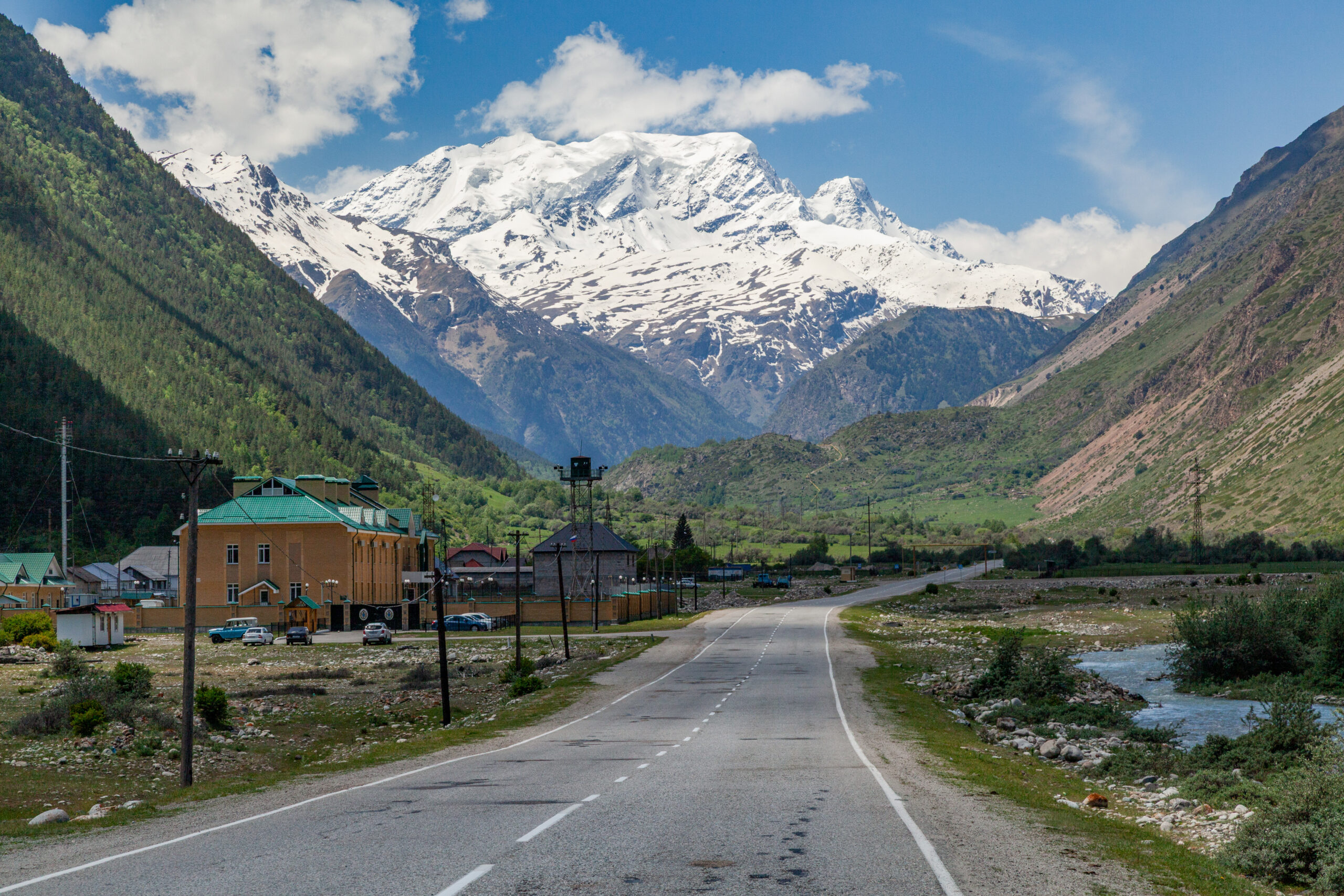
Mount Elbrus (5,642 m / 18,510 ft) is the highest peak in Europe and one of the Seven Summits. It offers two main climbing routes that could not be more different. Generally, the South Route is the standard commercial line. It is supported by cable cars, the iconic Garabashi Barrels Huts at 3,800 m, snowcat access to Pastukhov Rocks, and a network of high-altitude huts. Specifically, the North Route is the wild, infrastructure-free alternative from Emanuel Glade (2,500 m). It has no cable cars and no snowcats. Climbers ascend entirely on foot, just as Khillar Khachirov first did in 1829. Notably, both routes reach the same West Summit but demand very different commitments. This guide compares them head-to-head: camps, elevations, summit-day logistics, difficulty grades, success rates, and which route fits your experience level.
Mount Elbrus rises 5,642 m above the Caucasus as the highest peak in Europe and one of the Seven Summits. Generally, the mountain offers two principal climbing routes — the South Route and the North Route — that represent two completely different mountaineering experiences. Specifically, the South Route is the convenient, hut-supported standard line, while the North Route is the wild, self-sufficient expedition alternative. Notably, choosing between them is the single most important decision a prospective Elbrus climber makes, and this guide compares them on every factor that matters.
This page is part of the complete Mount Elbrus Climb Guide system. For the full picture, pair this comparison with three sibling guides. Read our Elbrus permits guide, the complete gear list, and the Elbrus training plan. Generally, climbers building toward the full Seven Summits have two more resources. Review our Elbrus progression plan and the Aconcagua vs Denali vs Elbrus comparison for first-big-mountain decisions.
South Route vs North Route — The Quick Comparison
Before diving into route details, here is the head-to-head comparison that answers most climbers’ core question. Generally, the South Route wins on convenience, success rate, and accessibility, while the North Route wins on solitude, authenticity, and adventure. Specifically, the table below summarizes the decisive differences. Notably, both routes summit the same 5,642 m West Summit and require identical crampon, ice axe, and cold-weather competence.
Find Hotels, Flights & Trips for the World’s Best Hiking Destinations
The Global Summit Guide Travel Shop on Expedia — curated for outdoor adventurers, mountaineers, and serious hikers. Patagonia to the Alps. Nepal to the Rockies. Curated lodging for every region we cover.
Explore Travel Shop on Expedia →| Factor | South Route | North Route |
|---|---|---|
| Base / start | Azau (~2,350 m) · cable car access | Emanuel Glade (2,500 m) · 4×4 access |
| High camp | Garabashi Barrels Huts (3,800 m) | High Camp huts (3,800 m) |
| Mechanical support | Cable cars + chairlift + snowcats | None — entirely on foot |
| Accommodation | Barrels, Leaprus, Heart of Elbrus huts | Basic huts / tents at base + high camp |
| Acclimatization high point | Pastukhov Rocks (4,700-4,800 m) | Lenz Rocks (4,800 m) |
| Difficulty grade | Russian 2A · basic snow/ice | Russian 2B · longer, more committing |
| Typical program | 7-8 days | 10-11 days |
| Success rate | 80-90% | 50-70% |
| Crowds | Busy · most popular route | Quiet · few climbers |
| Best for | First-timers · Seven Summits aspirants | Experienced climbers · expedition purists |
| Historic significance | Modern commercial standard | 1829 first-ascent line (Khachirov) |
The South Route — Cable Cars, Barrels, and Snowcats
South Route — The Standard Commercial Line
The South Route is by far the most frequented Elbrus line and the standard path for the majority of climbers. Generally, the route benefits from a network of cable cars, chairlifts, huts, and snowcats that handle logistics and aid acclimatization. Specifically, climbers start from Azau in the Baksan Valley at approximately 2,350 m. From there they ride a series of cable cars plus a final chairlift to Garabashi Station at around 3,800 m. Notably, this mechanical support makes the South Route the easiest of the Seven Summits ascents in terms of technical demand.
The iconic Barrels Huts (Bochki) at 3,800 m serve as the standard high camp. Generally, these are large metal cylinders — former Soviet-era fuel storage tanks — repurposed into insulated shelters, each sleeping 6 climbers. Specifically, the Garabashi base sits 50 meters from the chairlift’s top station and includes a separate dining building. Notably, higher and more comfortable alternatives exist. These include the Leaprus Eco-Hotel (3,910 m), the Heart of Elbrus hotel (3,820 m), and the historic Diesel Hut (4,050 m). The Shelter 11 site marks the remains of what was once the highest mountain hotel in Europe before it burned down.
Acclimatization on the South Route centers on Pastukhov Rocks at 4,700-4,800 m. Generally, climbers hike to the rocks and return to the Barrels over one or two acclimatization days. Specifically, a snowcat can ferry climbers as high as Pastukhov Rocks on summit day, significantly reducing the physical load. Notably, this snowcat option is one of the defining features of the South Route. It lets climbers start summit day from 4,800 m rather than 3,800 m. This dramatically improves success rates for those who use it.
Summit day begins around 1-2 AM. Generally, the climb from the Barrels (or the snowcat drop at Pastukhov Rocks) takes 6-9 hours to the West Summit. Specifically, the route ascends to the Kosaya Shelf — a long diagonal traverse — then reaches the Saddle at 5,300 m between the two summits. Notably, climbers rest at the Saddle before the final steep push to the West Summit at 5,642 m. The total height difference between the Barrels and the West Summit is approximately 1,800-1,900 m. Descent takes an additional 2-3 hours back to the Barrels.
The snowcat advantage. Generally, the South Route’s optional snowcat transport to Pastukhov Rocks (4,700-4,800 m) is the single biggest factor in its high success rate. Specifically, climbers who use the snowcat begin summit day already at 4,800 m. This cuts roughly 1,000 m of climbing and several hours off the summit push. Notably, purists climb the full route on foot, but most commercial operators include the snowcat option for summit day. The combination of cable cars for the approach and snowcats for the summit makes the South Route uniquely accessible among the Seven Summits. Even so, altitude, cold, and wind still make it a serious undertaking. See our Elbrus training plan to prepare properly regardless of route.
The North Route — Wild, On Foot, and Historic
North Route — The 1829 First-Ascent Line
The North Route is the wild, infrastructure-free alternative to the South Route. Generally, there are no hotels, restaurants, cable cars, or snowcats on the northern side. Specifically, climbers make the entire ascent on foot, just as the first ascensionists did in 1829. Notably, the North Route is the historic line. Khillar Khachirov reached the East Summit via the north side on July 10, 1829. He climbed during General Georgy Emanuel’s Russian Academy of Sciences expedition.
The journey begins in the spa town of Kislovodsk. From there a 4×4 vehicle carries climbers to the base camp on Emanuel Glade (also called Emanuel Meadows) at 2,500 m. Generally, the nearby Dzhily-Su area is famous for its curative mineral springs. Specifically, the base camp offers basic facilities. Some operators provide huts with showers and toilets. Even so, the experience is fundamentally more rustic than the South Route. Notably, the approach to High Camp at 3,800 m leads through a gorge and alpine meadows. It passes the Mikelchiran Glacier moraine, then climbs a steep slope.
Acclimatization on the North Route centers on Lenz Rocks at 4,800 m. Generally, climbers ascend through snow and ice fields to the rocks and return to High Camp. Specifically, the crevasse zone begins around 3,900 m, where climbers put on crampons, rope up, and move as a team. Notably, the North Route requires roped glacier travel skills earlier and more consistently than the South Route. See our glacier travel basics and crevasse rescue basics guides for essential preparation.
Summit day on the North Route is longer and more committing than the South. Generally, the lack of mechanical assistance means climbers carry heavier loads and cover more vertical on foot. Specifically, the route can reach either the East Summit (5,621 m, the 1829 first-ascent peak) or continue to the higher West Summit (5,642 m). Notably, North Route programs typically run 10-11 days versus 7-8 for the South Route, reflecting the longer approach and more conservative acclimatization. The reward is solitude, untouched wilderness, and an authentic alpine experience away from the South Route crowds.
The North Route demands more. Generally, the North Route’s 50-70% success rate (versus 80-90% on the South) reflects its greater demands rather than greater technical difficulty. Specifically, climbers face heavier loads, longer summit days, no snowcat shortcut, and more basic accommodation. Notably, the North Route suits experienced mountaineers who have already climbed at altitude and want a true expedition rather than a hut-to-hut climb. First-time high-altitude climbers should choose the South Route. Review our mountaineering fitness standards and fitness assessment checklist to gauge readiness for either route.
Alternative and Less-Traveled Routes
East Route, West Route, and Traverse Options
Beyond the South and North Routes, several alternative lines exist for experienced climbers. Generally, these routes see far less traffic and demand greater self-sufficiency, route-finding, and technical skill. Specifically, the East Route approaches from the Irikchat Pass and is sometimes combined with ski descents. Notably, the West Route is the least-traveled standard approach and requires full expedition logistics with no infrastructure whatsoever.
The most ambitious option is the full Elbrus Traverse, crossing from one side of the massif to the other over both summits. Generally, this requires strong acclimatization, settled weather, and experienced guiding. Specifically, the traverse combines the wilderness character of the North Route with the logistics of a point-to-point expedition. Notably, these alternatives are rarely offered commercially — most climbers choosing variety beyond the South Route opt for the North Route instead. For climbers weighing Elbrus against other first big mountains, our Aconcagua vs Denali vs Elbrus comparison provides decision frameworks.
Gear Differences Between the Routes
Both routes require the same core mountaineering kit, but the North Route demands additional self-sufficiency. Generally, the South Route’s hut network and snowcat support reduce what climbers must carry. Specifically, the North Route requires more robust camping gear, heavier loads, and full glacier-travel equipment carried throughout. Notably, the table below summarizes the route-specific differences — for the complete kit, see the dedicated Elbrus gear list.
| Gear Category | South Route | North Route |
|---|---|---|
| Boots | Insulated double mountaineering boots (B2/B3) | Same · stiffer technical boots for longer days |
| Crampons + ice axe | 12-point crampons · single ice axe | Same · used earlier and more consistently |
| Glacier travel kit | Harness · prusiks · 1-2 carabiners | Full kit · roped travel from 3,900 m crevasse zone |
| Clothing | Layered system · expedition down jacket | Same plus extra insulation for colder, exposed camps |
| Sleeping system | Hut bedding often available · bag to -15°C | Expedition bag to -20°C · self-sufficient camping |
| Pack size | 40-50 L (huts reduce carried load) | 60-70 L (more self-carried gear) |
| Navigation | GPS · marked route · guide-led | GPS essential · less-marked wilderness terrain |
| Safety gear | Basic first aid · communication device | Comprehensive first aid · satellite device essential |
Success Factors — What Separates Summit From Turnaround
Elbrus success on either route depends far more on preparation and weather than on technical skill. Generally, the mountain is non-technical but unforgiving of poor acclimatization, weak fitness, and bad weather decisions. Specifically, four factors drive the difference between the South Route’s 80-90% success and the North Route’s 50-70%. Notably, climbers can directly influence three of the four.
| Success Factor | Why It Matters | How to Optimize |
|---|---|---|
| Acclimatization | 5,642 m summit causes AMS in poorly acclimatized climbers | Follow staged ascent · climb-high-sleep-low · Pastukhov/Lenz Rocks hikes |
| Physical fitness | 6-9 hr (South) or longer (North) summit days demand endurance | 3-4 months training · long hikes with elevation gain |
| Weather window | Storms and wind force turnarounds even from the Saddle | Build buffer days · climb July-August · honor turnarounds |
| Route choice | Snowcat support (South) dramatically aids summit day | Match route to experience · use snowcat if available |
Hypoxic training research. Generally, beyond traditional acclimatization, some studies suggest pre-trip hypoxic training improves high-altitude performance. Specifically, a 2017 study by V. Mulyk found that intermittent hypoxic training in a 15-15 mode before an Elbrus ascent significantly increased attention metrics of qualified climbers at different altitude levels. Notably, while not a substitute for proper acclimatization on the mountain, hypoxic pre-conditioning may offer marginal gains for serious climbers. The foundation remains staged acclimatization — see our altitude acclimatization guide and AMS risk calculator for evidence-based protocols.
Mount Elbrus Route History — Khachirov to Modern Climbing
The two routes carry distinct historical significance. Generally, the North Route is the line of the first ascent, while the South Route became the modern commercial standard with Soviet-era infrastructure. Specifically, the climbing history of Elbrus spans nearly two centuries from the 1829 first ascent to today’s cable-car-supported climbs. Notably, understanding this history enriches the route choice — climbing the North Route follows literal first-ascent footsteps.
| Year | Event | Route Significance |
|---|---|---|
| July 10, 1829 | Khillar Khachirov first ascent of East Summit | North side · General Emanuel’s Academy of Sciences expedition |
| 1829 | Akhia Sottaiev also reaches East Summit | Balkar guide · would later guide the West Summit first ascent |
| 1874 | West Summit first ascent | F. Crauford Grove + Gardiner + Walker + Knubel + Sottaiev |
| 1874 | Sottaiev becomes first to climb both summits | Age 86 · 45 years after his 1829 East Summit climb |
| 1960s | Soviet cable car system built | Establishes the South Route as the accessible standard |
| 1956 | 400-climber mass ascent | 400th anniversary of Kabardino-Balkaria |
| September 13, 1997 | Land Rover driven to summit | Alexander Abramov · Guinness world record vehicle ascent |
| Modern era | Seven Summits popularity | South Route becomes a Seven Summits standard objective |
The 1829 first ascent remains the defining historical event. Generally, General Georgy Emanuel led the Imperial Russian army scientific expedition, organized with support from the Russian Academy of Sciences. Specifically, only the Karachay/Kabardian guide Khillar Khachirov reached the East Summit (5,621 m), marking his achievement by firing three rifle shots. Notably, the West Summit — only about 21 m higher at 5,642 m — was not climbed until 1874 by F. Crauford Grove’s British expedition. The Balkar guide Akhia Sottaiev had reached the East Summit in 1829. He guided that 1874 West Summit ascent and became the first person to summit both peaks at the remarkable age of 86.
Summit Day Breakdown by Route
Summit day differs significantly between the two routes. Generally, both start in the early morning hours and demand 8-12 total hours of effort. Specifically, the South Route’s snowcat option can shorten the climb significantly, while the North Route requires the full ascent on foot. Notably, the table below breaks down the summit-day stages for each route.
| Stage | South Route | North Route |
|---|---|---|
| Wake / start | 1-2 AM from Barrels (3,800 m) | 1-2 AM from High Camp (3,800 m) |
| Optional transport | Snowcat to Pastukhov Rocks (4,800 m) | None — on foot |
| Mid-mountain landmark | Pastukhov Rocks (4,700-4,800 m) | Lenz Rocks (4,800 m) |
| Traverse | Kosaya Shelf diagonal traverse | Glacier slopes to summit plateau |
| Final rest | Saddle at 5,300 m | Summit plateau approach |
| Summit | West Summit 5,642 m | East (5,621 m) or West (5,642 m) |
| Ascent time | 6-9 hours | 8-12 hours |
| Descent time | 2-3 hours to Barrels | 3-4 hours to High Camp |
Best Time to Climb Each Route
Both Elbrus routes share the same primary climbing season. Generally, the window runs from late June through early September, with July and August offering the most stable weather. Specifically, the cable cars, barrel huts, and snowcats on the South Route remain open and accessible throughout this window. Notably, outside this season climbing becomes more technical because of heavier snowfall, colder temperatures, and reduced visibility on both routes.
| Period | Conditions | Route Notes |
|---|---|---|
| May – mid June | Early season · more snow · colder | South Route possible · North Route challenging · ski season overlap |
| Late June – July | Peak season opening · stabilizing weather | Both routes optimal · firmer snow · full infrastructure open |
| August | Peak season · most stable weather | Best success rates both routes · busiest on South Route |
| Early September | Late season · still good · cooling | Good window · fewer crowds · weather check essential |
| October – April | Off-season · winter conditions | Technical winter climbing only · most operators closed |
Which Route Should You Choose?
The route decision comes down to experience, goals, and tolerance for hardship. Generally, the South Route is the right answer for most climbers, while the North Route rewards those seeking a wilder experience. Specifically, the decision framework below maps climber profiles to the best route. Notably, both routes reach the same summit and neither is technically difficult — the choice is about the style of experience.
Choose the South Route If…
The South Route suits the majority of Elbrus climbers. Generally, it is the right choice for first-time high-altitude climbers and Seven Summits aspirants. Specifically, choose the South Route if you match these criteria:
- This is your first major high-altitude climb or first Seven Summit
- You want mechanical support — cable cars for the approach, snowcats for summit day
- You prefer hut accommodation (Barrels, Leaprus, Heart of Elbrus) over camping
- You value the highest success rate (80-90%)
- You have a tighter schedule (7-8 day programs)
- You are building toward the Seven Summits and want an efficient Elbrus tick
- You want maximum on-mountain support and infrastructure
Choose the North Route If…
The North Route suits experienced mountaineers seeking authenticity. Generally, it is the right choice for climbers who have already climbed at altitude and want a true expedition. Specifically, choose the North Route if you match the criteria below:
- You are an experienced high-altitude climber with prior glacier experience
- You want a wild, expedition-style experience with no mechanical assistance
- You prefer solitude and want to avoid the South Route crowds
- You want to climb the historic 1829 first-ascent line
- You can commit to a longer 10-11 day program
- You are comfortable carrying heavier loads and camping in basic conditions
- You have solid glacier travel and crevasse rescue skills
Frequently Asked Questions About Mount Elbrus Routes
What is the difference between the Mount Elbrus South Route and North Route?
The South Route is the standard commercial line supported by cable cars, the Garabashi Barrels Huts at 3,800 m, snowcat access to Pastukhov Rocks, and multiple high-altitude huts. The South Route handles the vast majority of climbers and has success rates of 80-90%. The North Route is a wild, infrastructure-free alternative from Emanuel Glade base camp (2,500 m) — no cable cars, hotels, restaurants, or snowcats. Climbers make the North Route ascent entirely on foot via High Camp (3,800 m) and Lenz Rocks (4,800 m). This is the same line Khillar Khachirov used for the first ascent in 1829. The North Route has lower success rates (50-70%) because of the longer approach, heavier loads, and lack of mechanical support. The South Route suits first-time climbers while the North Route suits experienced mountaineers seeking a true expedition experience.
Who first climbed Mount Elbrus?
Khillar Khachirov, a local Karachay/Kabardian guide, made the first recorded ascent of Mount Elbrus’s East Summit (5,621 m) on July 10, 1829. He climbed as part of General Georgy Emanuel’s Russian Academy of Sciences scientific expedition organized and financed by the Imperial Russian army. Only Khachirov reached the summit, marking his achievement by firing three rifle shots. The higher West Summit (5,642 m) was first climbed in 1874 by a British expedition led by F. Crauford Grove, including Frederick Gardiner, Horace Walker, and Swiss guide Peter Knubel. The Balkar guide Akhia Sottaiev had reached the East Summit in 1829. He guided the 1874 West Summit ascent and became the first person to climb both summits, at age 86. The first ascent route from the north is still climbed today as the North Route.
How hard is the Mount Elbrus South Route?
The Mount Elbrus South Route is graded Russian 2A. It is a basic snow and ice climb requiring crampons and an ice axe, but no prior technical climbing experience. The route is considered the easiest of the Seven Summits ascents. The difficulty comes from altitude (5,642 m summit), summit-day length, cold, and strong winds. The terrain itself is not technical. The South Route benefits from cable cars to Garabashi (3,800 m), a network of huts, and optional snowcat transport to Pastukhov Rocks (4,700-4,800 m). The snowcat significantly reduces summit-day physical load. The crux sections are the Kosaya Shelf traverse and the steep climb from the Saddle (5,300 m) to the West Summit. Success rates run 80-90% for properly acclimatized climbers in good weather.
What are the camps on the Mount Elbrus South Route?
The Mount Elbrus South Route uses a series of cable-car-accessed high-altitude shelters rather than traditional tent camps. Climbers start at Azau (around 2,350 m) and take cable cars and a chairlift to Garabashi Station at approximately 3,800 m. The iconic Barrels Huts (Bochki) at 3,800 m are repurposed metal fuel-storage cylinders, each sleeping 6 climbers. Higher options include the Diesel Hut (4,050 m), the Leaprus Eco-Hotel (3,910 m), and the Heart of Elbrus hotel (3,820 m). The historic Shelter 11 site marks the remains of what was once the highest mountain hotel in Europe before it burned down. Pastukhov Rocks (4,700-4,800 m) serve as the standard acclimatization high point and the optional snowcat drop-off for summit day. The Saddle at 5,300 m is the final rest point between the two summits before the West Summit push.
Which Mount Elbrus route should I choose?
Choose the South Route if you are a first-time high-altitude climber, want mechanical support (cable cars and snowcats), prefer hut accommodation, value higher success rates (80-90%), or have a tighter schedule (7-8 day programs). The South Route is the standard choice for the majority of Elbrus climbers and Seven Summits aspirants. Choose the North Route if you are an experienced mountaineer, want a wild expedition-style experience with no mechanical assistance, prefer solitude away from crowds, want to climb the historic 1829 first-ascent line, and can commit to a longer 10-11 day program with heavier loads. The North Route demands greater self-sufficiency, fitness, and tolerance for basic conditions but rewards climbers with an authentic alpine experience. Both routes reach the same 5,642 m West Summit and require the same crampon, ice axe, and cold-weather skills.
Can you take a snowcat on Mount Elbrus?
Yes, snowcats are available on the South Route and can ferry climbers as high as Pastukhov Rocks (4,700-4,800 m) on summit day. This option significantly reduces the summit-day physical load by cutting roughly 1,000 m of climbing and several hours from the ascent. Climbers who use the snowcat begin summit day already at 4,800 m rather than 3,800 m. This is the single biggest factor behind the South Route’s high 80-90% success rate. Most commercial South Route operators include the snowcat option for summit day, though purists climb the full route on foot. The North Route has no snowcat access. Climbers make the entire ascent on foot. This is one reason its success rate is lower at 50-70%.
How long does it take to climb Mount Elbrus?
A South Route Mount Elbrus expedition typically takes 7-8 days including acclimatization hikes, rest days, and a weather buffer day. The North Route takes longer at 10-11 days because of the longer approach and more conservative acclimatization schedule. On summit day itself, the South Route climb takes 6-9 hours to the West Summit plus 2-3 hours descent. The North Route takes 8-12 hours ascent plus 3-4 hours descent. The total height difference between the Barrels Huts (3,800 m) and the West Summit (5,642 m) is approximately 1,800-1,900 m. Climbers using the snowcat to Pastukhov Rocks (4,800 m) shorten summit day considerably. Both routes require several days of acclimatization before the summit attempt to safely adjust to the 5,642 m altitude.
When is the best time to climb Mount Elbrus?
The best time to climb Mount Elbrus on either route is July through September, the main climbing season. During these months the weather is relatively stable and the snow is firmer. The cable cars and barrel huts remain open and accessible on the South Route. July and August offer the most stable weather and highest success rates. Late June and early September are good shoulder periods with fewer crowds. Outside this window, climbing becomes more technical because of heavier snowfall, colder temperatures, and reduced visibility. October through April is winter climbing only, with most operators closed. Climbers should always build buffer days into their schedule to allow for weather delays. Storms and high winds can force summit-day turnarounds on both routes.
How high is Mount Elbrus and how many summits does it have?
Mount Elbrus has two summits. The West Summit reaches 5,642 m (18,510 ft) and the East Summit 5,621 m (18,442 ft), about 21 m lower. The West Summit is the true highest point of Europe and the standard Seven Summits objective. Mount Elbrus is a dormant stratovolcano in the Caucasus range of southwest Russia, near the Georgian border. It is the tenth-most prominent peak in the world and the highest volcano in Eurasia. The East Summit was first climbed in 1829 by Khillar Khachirov, while the West Summit was first reached in 1874. The mountain’s last recorded eruption occurred around 50 AD. Both the South Route and North Route can reach either summit, though most climbers target the higher West Summit.
Mount Elbrus Routes Related Resources
Sources & Verified References
- Wikipedia: Mount Elbrus — Summit elevations, first ascent history, and geological data
- RMH Elbrus Guides (russianmountainholidays.com) — North Route itinerary, Lenz Rocks, 1829 history
- Elbrus Tours (elbrustours.ru) — South and North Route itineraries, camps, and acclimatization schedules
- MountainIQ (mountainiq.com) — Garabashi Barrels Huts, Shelter Maria, and South Route logistics
- Adventure Pulse (adventure-pulse.com) — 2026 South Route Seven Summits itinerary and hut details
- Snowrush (snowrush.net) — North and South Route comparison, Diesel Hut, summit times
- Lifetrek (lifetrek.eu) — South Route cable car, snowcat, and Pastukhov Rocks logistics
- Elbrus Barrels (elbrus-barrels.com) — Garabashi base camp accommodation details
- Trek The Himalayas (trekthehimalayas.com) — 2026 Elbrus expedition season and itinerary structure
- V. Mulyk (2017) — “Hypoxic Training for Mount Elbrus Ascent” attention metrics study
- Effective Expedition Planning (1997) — Expedition planning methodology reference
Last updated: May 27, 2026. Next scheduled update: October 2026 (post-season update incorporating 2026 climbing season data, updated South Route hut and snowcat operations, and any North Route access changes).
Plan Your Mount Elbrus Climb
The South Route and North Route offer two completely different paths to Europe’s highest summit. Generally, the South Route is the convenient, high-success standard while the North Route is the wild, historic alternative. Notably, your route choice shapes everything else — permits, gear, training, and itinerary. Continue with the full Elbrus guide system to plan every detail of your 5,642 m ascent.
Return to Main Elbrus Guide →This peak is one of the Seven Summits — the highest peak on every continent
The Seven Summits are mountaineering’s most iconic geographic challenge — climbing the highest peak on each of the seven continents. See the complete collection covering Bass vs Messner lists, all 7 peaks in detail, full Dick Bass to Nims Purja history, and realistic cost breakdown from $150K to $300K+ across 3-7 years.
View All Seven Summits →🏔 Part of the Seven Summits
One of the highest peaks on each continent. See all 7 with Bass vs Messner lists, costs, and history.
View All Seven Summits →Mount Everest belongs to both the Seven Summits and the 14 Eight-Thousanders
As the highest peak on Earth (8,849m), Mount Everest is the headline summit of mountaineering’s two most iconic collections. The Seven Summits requires climbing the highest peak on every continent; the 14 Eight-Thousanders requires climbing every mountain above 8,000 meters.
Seven Summits → 14 Eight-Thousanders →Mount Elbrus is the Anchor Peak of the Caucasus Range
Mount Elbrus (5,642m) is Europe’s highest peak, a Seven Summit, and the anchor of the Caucasus mountain range — which contains 12 peaks above 5,000 meters, more than the entire European Alps. The full Caucasus collection covers all 10 major peaks across Russia, Georgia, Armenia, and Turkey.
Generally, Elbrus is the most-climbed of the Caucasus high peaks (~15,000-20,000 attempts per year). Specifically, the broader collection includes the technical Bezengi Wall (Dykh-Tau, Shkhara, Koshtan-Tau), the sacred Mount Kazbek in Georgia, biblical Mount Ararat in Turkey, and the Matterhorn-like Ushba.
Caucasus Mountains Collection → Mount Kazbek (Georgia) →Was this helpful?
🏔Related guides
🧭Explore & compare
Global Summit Guide is an independent mountaineering resource founded in 2026. The team combines first-hand trekking and climbing experience with in-depth research and professional health and nutrition review to help climbers choose objectives, prepare properly, and stay safe.
Health, altitude, and nutrition content is reviewed by Taylor Ludlow (Registered Nurse) and Brigg Hoopes (Nutritionist).
What We Don't Know Yet
Mountain information changes quickly. This box explains the limits of what this page can responsibly promise.
- Route conditions, trailhead access, crevasse exposure, stream crossings, and rescue access may vary from published planning guidance.
- Comparisons simplify complex decisions; the better mountain depends on current conditions, skills, timing, budget, and risk tolerance.
- Route conditions, snowpack, closures, and weather can change quickly after this page is updated.
- Permit rules, fees, quotas, and reservation windows may change between review cycles.
- Operator availability, pricing, guide ratios, and cancellation terms can change by season.
Verify current conditions with official land managers, guide services, local forecasts, and current route reports before booking or climbing.
Part of this Global Summit Guide cluster
Explore the complete Mountains guide for more context, routes, planning links, and related resources.
Mountaineering, rock and ice climbing, glacier travel, and high-altitude activity are inherently dangerous and can result in serious injury or death. The information on Global Summit Guide is provided for general informational and educational purposes only and is not a substitute for professional instruction, qualified guiding, proper equipment, or your own judgment and experience.
Route conditions, weather, snowpack, permits, regulations, and hazards change constantly and may differ from what is described here. Details may be incomplete, out of date, or contain errors. Always verify current information with local authorities, certified guides, and official sources before making any decision in the mountains.
Nothing on this site is medical, legal, or financial advice. Our fitness, acclimatization, altitude, and nutrition content is general in nature; consult a qualified physician before beginning any strenuous exercise program or exposing yourself to high altitude.
You are solely responsible for your own safety and decisions. To the fullest extent permitted by law, Global Summit Guide and its team accept no liability for any loss, injury, damage, or expense arising from use of, or reliance on, this information. By using this site you acknowledge these risks and accept these terms.
Some links on this site may be affiliate links. If you buy through them we may earn a small commission at no extra cost to you; this never affects our recommendations.
Global Summit Guide recommendation path
Next Best Mountain to Research
Use these recommendations to continue the right planning path instead of stopping on one page.
Use current permit, weather, route, and operator information before booking or climbing.