
Last updated July 10, 2026
Mount Ruapehu: Ski Fields, the Crater Lake & the Summit
The North Island’s highest mountain is a rare one: two ski fields, an active Crater Lake, a serious alpine summit, and the world-famous Tongariro Crossing next door — all on one volcano in one national park. Here’s how the pieces fit together, and what’s actually true in 2026.
Mount Ruapehu (2,797 m) is the highest peak in New Zealand’s North Island and one of the world’s most active volcanoes. It offers three very different experiences: easy lift-served skiing and sightseeing at Whakapapa and Tūroa; a demanding alpine walk to the Crater Lake and summit; and, right next door in the same park, the famous Tongariro Alpine Crossing.
The single most important thing to get straight: the Tongariro Crossing is not on Ruapehu. It’s on the neighbouring Tongariro and Ngauruhoe volcanoes. People often base near Ruapehu and do both — but they’re separate days on separate mountains. And because Ruapehu is a live volcano, every plan starts with the GeoNet alert level.
On this page
Where it is
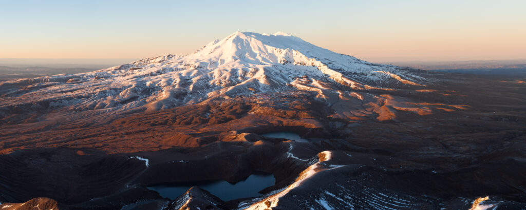
Central North Island — Tongariro National Park, with a ski field on each flank.
Find Hotels, Flights & Trips for the World’s Best Hiking Destinations
The Global Summit Guide Travel Shop on Expedia — curated for outdoor adventurers, mountaineers, and serious hikers. Patagonia to the Alps. Nepal to the Rockies. Curated lodging for every region we cover.
Explore Travel Shop on Expedia →Ruapehu sits at the southern end of the Taupō Volcanic Zone in Tongariro National Park, central North Island. Two ski areas face opposite ways — Whakapapa on the northern slopes (accessed from Whakapapa Village) and Tūroa on the southwestern slopes (accessed from Ohakune) — with the Crater Lake near the summit between them.
The mountain, in brief
An active volcano, an ancestor, and a film set.
At 2,797 m, Ruapehu is the highest mountain in the North Island and one of the world’s most active composite (andesitic) volcanoes, last erupting in a major way in 1995–96. Its true summit is Tahurangi; near it sits the active vent, filled by the Crater Lake, Te Wai ā-moe. Three summit craters have been active over the last 10,000 years, and the mountain regularly produces lahars — volcanic mudflows — when lake water is thrown onto the surrounding snow and ice.
Ruapehu is deeply sacred to Ngāti Tūwharetoa. In 1887 the paramount chief Te Heuheu Tūkino IV (Horonuku) gifted the sacred peaks to the nation, creating Tongariro — the world’s first national park established through such a gift, and the fourth national park anywhere. Film fans will also recognise Ruapehu’s slopes as Mordor in The Lord of the Rings (neighbouring Ngauruhoe played the cone of Mount Doom). Treat the mountain as the living ancestor it is to the people who hold it.
Four ways to experience it
Pick the one that matches your plans — they’re very different days.
| Experience | Effort | Season | What it is |
|---|---|---|---|
| Ski / sightsee | Easy–hard | Winter (Jun–Oct) | Lift-served skiing, tubing, and gondola sightseeing at Whakapapa or Tūroa |
| Crater Lake / Summit Plateau | Hard | Summer best | Unformed alpine walk/climb to the crater rim and summit — guided or expert-independent |
| Round the Mountain Track | Multi-day | Summer | ~66 km, 4–6 day advanced tramping loop around the whole massif |
| Tongariro Alpine Crossing | Moderate–hard | Summer best | The famous day walk — on the neighbouring Tongariro/Ngauruhoe, same park |
Skiing: Whakapapa & Tūroa
New Zealand’s two biggest ski areas — under new management for 2026.
Ruapehu is home to the North Island’s only commercial skiing, across two areas on opposite flanks. After the former operator, Ruapehu Alpine Lifts, collapsed in 2022–23, the fields were split: Whakapapa is now run by Whakapapa Holdings and Tūroa by Pure Tūroa, each on a 10-year Department of Conservation concession. Both operate for the 2026 winter.
| Field | Side / base town | Signature | 2026 operator |
|---|---|---|---|
| Whakapapa | North · Whakapapa Village | NZ’s largest area (~550 ha); Sky Waka gondola; Happy Valley beginner zone | Whakapapa Holdings |
| Tūroa | Southwest · Ohakune | Australasia’s longest vertical (722 m); base ~1,600 m, top lift ~2,322 m | Pure Tūroa |
| Tūkino | East | Small volunteer-run club field; weekends when snow allows | Tūkino club |
The season generally runs from around late June or early July into October, entirely snow-dependent. Beyond skiing and snowboarding, both fields sell sightseeing: Whakapapa’s Sky Waka gondola runs year-round to the Knoll Ridge Chalet, and there’s tubing and snowplay for non-skiers. In summer the lower mountain opens up for walks. One practical note for planners: the historic Chateau Tongariro hotel in Whakapapa Village remains closed, so book accommodation in Whakapapa Village, National Park Village, Ohakune, or Tūrangi instead.
The Crater Lake & summit walk
The classic Ruapehu objective — and more serious than it looks.
The upper mountain is an unmarked alpine environment, not a graded track. The most common objective is the crater rim and the Dome (about 2,672 m), reached from the top of the Whakapapa lifts — roughly a 7-hour return alpine route in good summer conditions. The true summit, Tahurangi (2,797 m), is a further, more committing objective. Many visitors do this as a guided Summit Plateau day hike (~9 hours) rather than independently.
Crater Lake / Summit Plateau (from Whakapapa)
Climb above the ski-field terrain toward the summit plateau and the crater-lake viewpoint. Non-technical in stable summer conditions, but it demands fitness, navigation, and good timing — and note the exclusion zone below means you view the lake from a distance rather than reaching its shore.
The Tongariro Crossing (next door)
The famous walk everyone means — on the neighbouring peaks.
Practical notes for 2026: the Crossing is point-to-point, so nearly everyone uses a shuttle (parking at the Mangatepopo trailhead is time-limited), and DOC now runs a booking system to manage numbers — check the current requirement before you go. It’s often closed or crampons-only in winter, and like Ruapehu it sits in a volcanic hazard zone: Tongariro and Ngauruhoe normally sit at Alert Level 0, and the track closes if that rises.
The Crater Lake & volcanic risk
Why every plan here starts with GeoNet.
The Crater Lake, Te Wai ā-moe, sits at about 2,300 m and is heated from below by the volcano. Its temperature cycles over months — often around 20–30°C, and historically swinging roughly between about 12°C and 40°C as heat flow rises and falls (in early 2026 it was running cool, near 18°C). The lake is the source of Ruapehu’s defining hazard: lahars. In 1953 a lahar from the lake destroyed a rail bridge at Tangiwai moments before a train crossed, killing 151 people — New Zealand’s worst rail disaster. A large lahar in 2007 was safely managed by a purpose-built warning system.
Upper-mountain weather
Live 7-day forecast for the upper mountain — updates automatically.
Ruapehu’s weather is notoriously fast-changing: clear skies can become whiteout and high wind within an hour, and it can snow in any month up high. The forecast below is for the upper mountain and refreshes each time the page loads. Villages and ski bases lower down are milder than these figures.
Mount Ruapehu — upper-mountain 7-day forecast
Loading live data…Getting there & when to go
Easy to reach — from either side of the mountain.
| Whakapapa Village (north) | ~4–4.5 hrs drive from Auckland; ~1.5 hrs from Taupō. Gateway to the Whakapapa ski field and Summit Plateau. |
| Ohakune (southwest) | Base town for the Tūroa ski field; lively in winter, good food and lodging. |
| National Park Village | Handy hub between Ruapehu and the Tongariro Crossing; on the main rail line. |
| Nearest airports | Taupō and Whanganui for regional flights; Wellington or Auckland for main connections. |
For skiing, aim for July–August (most reliable snow). For the Crater Lake and summit, stable summer conditions (December–March) are easiest and safest; winter and shoulder seasons are full alpine climbs. And whatever the season, the mountain’s real timetable is set by the weather, the avalanche forecast, and the volcano — not the calendar.
Frequently asked questions
Is the Tongariro Crossing on Ruapehu?
No. The Tongariro Alpine Crossing is on the neighbouring Tongariro and Ngauruhoe volcanoes, a short drive north in the same park. Ruapehu has its own walks (Crater Lake / Summit Plateau) and its own ski fields. Many people do both on separate days.
Are the ski fields open in 2026?
Yes — Whakapapa (run by Whakapapa Holdings) and Tūroa (Pure Tūroa) both operate for winter 2026 on 10-year DOC concessions, roughly late June/July to October. The historic Chateau Tongariro hotel remains closed.
Can you reach the Crater Lake?
You can walk to a viewpoint (about 7–9 hours return / guided from Whakapapa), but a 700 m exclusion zone around the lake applies at the current alert level, so you see it from a distance. Winter turns it into a full alpine climb.
How high is Ruapehu, and is it active?
2,797 m (9,177 ft), the North Island’s highest peak and an active andesitic volcano. It normally sits at Volcanic Alert Level 1 (minor unrest) and regularly produces lahars from its Crater Lake.
Do you need a guide?
Not by rule, but strongly recommended for the summit/Crater Lake, especially in winter. There’s no marked track up, weather changes fast, and it’s a live volcano. Guided Summit Plateau hikes are the common choice.
When should I go?
Skiing: July–August. Summit walking: stable summer (Dec–Mar). Always check GeoNet (alert level), MetService, and the avalanche advisory first.
How we built this
Research-based. This guide is compiled from the NZ Department of Conservation, GeoNet volcanic monitoring, and the Whakapapa and Pure Tūroa ski-field operators, cross-checked for elevation, ski operations, access, and the current volcanic alert level.
On Ruapehu, conditions and rules change constantly — ski dates depend on snow, the summit route depends on season, and access depends on the volcano. Treat the details here as planning background and confirm current status with GeoNet, DOC, and the operators before you travel.
Plan your Ruapehu trip the smart way
Decide your day first — ski, summit, or the Crossing next door — then check the volcano. The alert level and the avalanche forecast decide what’s possible; the operators handle the rest.
Ski fields (mtruapehu.com) → GeoNet volcanic status →Was this helpful?
🏔Related peaks nearby
🧭Explore & compare
Global Summit Guide is an independent mountaineering resource founded in 2026. The team combines first-hand trekking and climbing experience with in-depth research and professional health and nutrition review to help climbers choose objectives, prepare properly, and stay safe.
Health, altitude, and nutrition content is reviewed by Taylor Ludlow (Registered Nurse) and Brigg Hoopes (Nutritionist).
What We Don't Know Yet
Mountain information changes quickly. This box explains the limits of what this page can responsibly promise.
- Visa, passport, vaccination, border, insurance, and local transportation rules may change before your trip.
- Route conditions, snowpack, closures, and weather can change quickly after this page is updated.
- Permit rules, fees, quotas, and reservation windows may change between review cycles.
- Operator availability, pricing, guide ratios, and cancellation terms can change by season.
- Your fitness, altitude response, risk tolerance, and experience level may change what is safe or realistic.
Verify current conditions with official land managers, guide services, local forecasts, and current route reports before booking or climbing.
Part of this Global Summit Guide cluster
Explore the complete Mountains guide for more context, routes, planning links, and related resources.
Mountaineering, rock and ice climbing, glacier travel, and high-altitude activity are inherently dangerous and can result in serious injury or death. The information on Global Summit Guide is provided for general informational and educational purposes only and is not a substitute for professional instruction, qualified guiding, proper equipment, or your own judgment and experience.
Route conditions, weather, snowpack, permits, regulations, and hazards change constantly and may differ from what is described here. Details may be incomplete, out of date, or contain errors. Always verify current information with local authorities, certified guides, and official sources before making any decision in the mountains.
Nothing on this site is medical, legal, or financial advice. Our fitness, acclimatization, altitude, and nutrition content is general in nature; consult a qualified physician before beginning any strenuous exercise program or exposing yourself to high altitude.
You are solely responsible for your own safety and decisions. To the fullest extent permitted by law, Global Summit Guide and its team accept no liability for any loss, injury, damage, or expense arising from use of, or reliance on, this information. By using this site you acknowledge these risks and accept these terms.
Some links on this site may be affiliate links. If you buy through them we may earn a small commission at no extra cost to you; this never affects our recommendations.
Global Summit Guide recommendation path
Next Best Mountain to Research
Use these recommendations to continue the right planning path instead of stopping on one page.
Use current permit, weather, route, and operator information before booking or climbing.