
Last updated July 11, 2026
Climbing & Hiking Aoraki/Mount Cook: Hooker Valley, Mueller Hut & the Summit
New Zealand’s highest peak — sacred to Ngāi Tahu, ringed by glaciers, and three completely different mountains in one. An easy valley walk anyone can do, a steep alpine hut hike, and a summit that ranks among the most serious technical climbs in the Southern Hemisphere. Here’s how to match the mountain to what you’re actually here for.
Aoraki/Mount Cook (3,724 m) is really three mountains in one, and conflating them is dangerous. The Hooker Valley Track is an easy, flat walk with the best accessible view of the peak — anyone can do it. Mueller Hut is a steep but non-technical summer hike for fit trampers. The summit is neither: it’s a serious, committing technical alpine climb, guided or expert only, and the deadliest peak in New Zealand.
So decide honestly what you’re here for. For the view, walk the valley. For an alpine hut night, earn Mueller. For the summit, come with real mountaineering experience and a guide — its modest height fools people, and the mountain does not forgive it.
On this page
Find Hotels, Flights & Trips for the World’s Best Hiking Destinations
The Global Summit Guide Travel Shop on Expedia — curated for outdoor adventurers, mountaineers, and serious hikers. Patagonia to the Alps. Nepal to the Rockies. Curated lodging for every region we cover.
Explore Travel Shop on Expedia →Where it is
The Southern Alps, South Island — staged from Aoraki/Mount Cook Village.
Aoraki/Mount Cook stands on the Main Divide of the Southern Alps, in Aoraki/Mount Cook National Park (Canterbury), part of the Te Wāhipounamu UNESCO World Heritage Area. Everything is based at Aoraki/Mount Cook Village (~750 m), reached by State Highway 80 up the shore of Lake Pukaki, about 45 minutes from Twizel. The village is the trailhead for the valley walks and the staging point for flights onto the glacier for climbers.
The peak, in brief
New Zealand’s highest — and a mountain that has literally lost height.
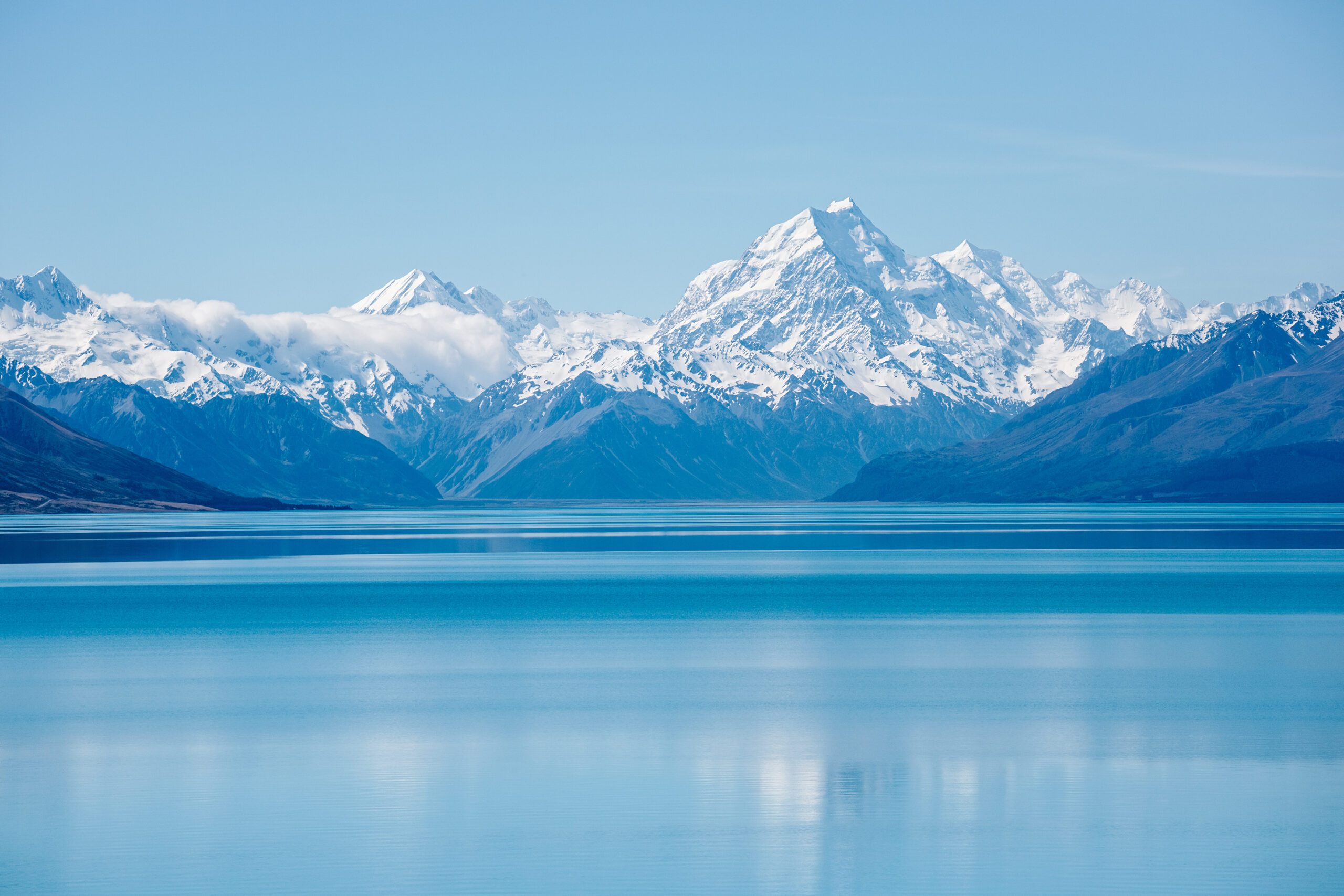
At 3,724 m (12,218 ft), Aoraki/Mount Cook is the highest mountain in New Zealand and the centrepiece of a park holding more than 140 peaks over 2,000 m and 72 glaciers. It has three summits — the Low Peak (3,593 m), Middle Peak (3,717 m), and the true High Peak (3,724 m). That height figure is newer than you might expect: a December 1991 rock avalanche tore roughly 10 m off the top, and after further ice loss the official height was revised from 3,754 m to 3,724 m in 2014. Despite its modest elevation by world standards, the mountain’s vertical relief, heavy glaciation, and violent maritime weather make it a seriously demanding peak.

Three mountains in one
Match your plan to your experience — the gap between them is enormous.
| Experience | Who it’s for | What it takes |
|---|---|---|
| Hooker Valley Track | Everyone | Easy, flat ~3 hr return walk; no experience needed |
| Mueller Hut Route | Fit hikers | Steep but non-technical in summer; a real alpine environment |
| The summit (Linda Glacier) | Expert / guided | Serious technical alpinism; glacier travel, mixed climbing, high objective hazard |
1 · The Hooker Valley Track
The best view of Aoraki that almost anyone can reach.
Hooker Valley Track to Hooker Lake
The park’s signature walk: a mostly flat, well-formed track from near the village, crossing three swing bridges up the Hooker Valley to Hooker Lake, a glacial lake that often carries floating icebergs, with Aoraki filling the head of the valley. It’s suitable for families and needs no experience — just layers, since valley weather turns fast.
2 · The Mueller Hut Route
A steep, rewarding alpine hike — a real taste of the high country.
Mueller Hut Route
A steep climb up the Sealy Range — past the Sealy Tarns steps and on up a marked route — to Mueller Hut (1,800 m), with a panorama of Aoraki, Mount Sefton, and the glaciers below. In summer (roughly December–April) it’s a non-technical but strenuous day hike or overnight; the hut is a popular DOC hut (28 bunks) that you should book ahead.
3 · The summit climb
New Zealand’s deadliest peak — serious, committing, and guided or expert only.
There is no walk-up route to the top of Aoraki. The standard line, the Linda Glacier route (with the North-East Ridge), grades NZ 3+/4 (roughly AD/D) and is used by around 80% of ascents — and even that is a long, hazardous climb that guides say is harder than Liberty Ridge on Mount Rainier.
| Base | Plateau Hut (2,200 m) on the Grand Plateau, reached by ski-plane or helicopter from Mount Cook Airport (most climbers fly in rather than make the long glacier approach). |
| Summit day | A ~1 a.m. start; 15–24 hours return with about 1,700 m of ascent. Up the Linda Glacier, across the Linda Shelf, past the ice-cliff “Gunbarrels,” through the mixed rock-and-ice Summit Rocks (several pitches) to the ice cap and summit — with abseils on descent. |
| Hazards | Crevasses, avalanche, and rock & ice fall from hanging glaciers overhead. The route passes below séracs that collapse without warning; speed and conditions are everything. |
| Season | Narrowed largely to November–December — earlier means soft snow and avalanche risk; later, the glacier becomes too broken and hazardous to guide. |
Getting there
Fly to Christchurch or Queenstown, drive to the village.
Most visitors reach Aoraki/Mount Cook Village by road from Christchurch (~4.5 hrs), Queenstown (~3.5 hrs), or nearby Twizel and Lake Tekapo, via SH8 and SH80 along Lake Pukaki. The village has the DOC visitor centre (weather, track status, the intentions system for climbers), a hotel and lodges, a campground, and cafés — but limited supplies, so stock up in Twizel. Climbers stage flights onto the glacier from Mount Cook Airport nearby.
Weather & season
Fast-changing maritime alpine weather — and a summit far colder than the village.
Aoraki sits on the Main Divide and catches the full force of Tasman Sea weather: it can shift from clear to storm within hours, with heavy precipitation and fierce nor’westers. The walks are year-round (wintry and icy from about May to September); the summit season is narrow, roughly November–February, with the Linda Glacier best in November–December. The live forecast below is for the village and refreshes on load.
Aoraki/Mount Cook Village (~750 m)
Loading live data…Name, meaning & history
A sacred ancestor — and a Christmas Day race to the top.
To Ngāi Tahu, the iwi of the South Island, Aoraki is the most sacred of ancestors — the source of the iwi’s identity. In tradition, Aoraki and his brothers came down from the sky in a canoe, were stranded when it capsized, and were turned to stone as the highest peaks of the Southern Alps. The Māori name (often glossed as “Cloud Piercer”) became the official first part of the dual name Aoraki/Mount Cook in 1998, through the Ngāi Tahu Claims Settlement.
The first recorded summit came on Christmas Day 1894, when three New Zealanders — Tom Fyfe, Jack (James) Clarke, and George Graham — climbed the north side, racing to beat a well-known European expedition to the prize. Matthias Zurbriggen made the second ascent in 1895 (via the ridge that now bears his name), and Freda du Faur became the first woman to summit in 1910. The 1991 avalanche that reshaped the summit is only the most dramatic chapter in a long, and often tragic, climbing history on New Zealand’s great mountain.
Frequently asked questions
How high is Aoraki/Mount Cook?
3,724 m (12,218 ft), the highest in New Zealand. That’s the 2014 figure — a 1991 rock avalanche removed ~10 m, and the official height was revised from 3,754 m to 3,724 m. It has three summits; the High Peak is the true top.
Can I walk up it?
No — there’s no walk-up to the summit. But you don’t need to summit to enjoy the mountain: the Hooker Valley Track is an easy flat walk with a superb view, and Mueller Hut is a steep non-technical summer hike. The summit is a serious climb.
How hard is the summit climb?
NZ 3+/4 via the Linda Glacier — a 15–24 hour summit day with ~1,700 m of ascent, glacier travel, and mixed climbing, under serious objective hazard. Guides rate it harder than Rainier’s Liberty Ridge. It’s New Zealand’s deadliest peak.
What does it cost and when’s the season?
Guided ascents run ~NZ$5,000–8,000+ for 4–7 days, plus NZ$400–1,200 each way for Plateau Hut flights. The climbing season has narrowed mainly to November–December; success runs ~30–50%.
What experience do I need to climb it?
A real technical base: prior glaciated ascents (e.g. Aspiring or Dixon), crevasse rescue, rock to ~Aus 14 / US 5.7, and the fitness for ~1,000 m in ~3–3.5 hours. Most guides only take clients who’ve done comparable peaks. Not a first big mountain.
Why “Aoraki/Mount Cook”?
Aoraki is the Ngāi Tahu name for the peak — their most sacred ancestor — made the official first part of the dual name in 1998. Climbers are asked to respect the mountain and, by tradition, not to stand on the exact summit.
How we built this
Research-based. This guide draws on the NZ Department of Conservation, ClimbNZ, and the IFMGA guide services that operate on Aoraki, cross-checked for elevation, routes, access, and season. We’ve been careful to keep the three experiences distinct — an easy valley walk, a hard alpine hike, and a deadly technical summit are not the same mountain — and to give the current 3,724 m height with its 1991/2014 back-story.
Track status, hut availability, fire and avalanche conditions, and prices change. Confirm current details with DOC, MetService, and your guide before any trip.
Meet New Zealand’s greatest mountain — at your level
Walk the Hooker Valley for the view of a lifetime, earn a night at Mueller Hut, or — with real alpine experience and a guide — take on the summit itself. Whatever you choose, check DOC and the forecast, and treat Aoraki with the respect it’s owed.
Oceania Icons → Glacier travel basics →Was this helpful?
🏔Related peaks nearby
🧭Explore & compare
Global Summit Guide is an independent mountaineering resource founded in 2026. The team combines first-hand trekking and climbing experience with in-depth research and professional health and nutrition review to help climbers choose objectives, prepare properly, and stay safe.
Health, altitude, and nutrition content is reviewed by Taylor Ludlow (Registered Nurse) and Brigg Hoopes (Nutritionist).
What We Don't Know Yet
Mountain information changes quickly. This box explains the limits of what this page can responsibly promise.
- Permit availability, reservation windows, quotas, and official fee rules may change after this page is updated.
- Guide-company prices, departure dates, guide ratios, included services, and cancellation rules can change without notice.
- Weather, snowpack, avalanche risk, road access, and route conditions can change quickly and may be different on your climbing dates.
- Route conditions, trailhead access, crevasse exposure, stream crossings, and rescue access may vary from published planning guidance.
- Total trip cost can change with flights, lodging, guide pricing, permits, gear rentals, transportation, and exchange rates.
Verify current conditions with official land managers, guide services, local forecasts, and current route reports before booking or climbing.
Part of this Global Summit Guide cluster
Explore the complete Mountains guide for more context, routes, planning links, and related resources.
Mountaineering, rock and ice climbing, glacier travel, and high-altitude activity are inherently dangerous and can result in serious injury or death. The information on Global Summit Guide is provided for general informational and educational purposes only and is not a substitute for professional instruction, qualified guiding, proper equipment, or your own judgment and experience.
Route conditions, weather, snowpack, permits, regulations, and hazards change constantly and may differ from what is described here. Details may be incomplete, out of date, or contain errors. Always verify current information with local authorities, certified guides, and official sources before making any decision in the mountains.
Nothing on this site is medical, legal, or financial advice. Our fitness, acclimatization, altitude, and nutrition content is general in nature; consult a qualified physician before beginning any strenuous exercise program or exposing yourself to high altitude.
You are solely responsible for your own safety and decisions. To the fullest extent permitted by law, Global Summit Guide and its team accept no liability for any loss, injury, damage, or expense arising from use of, or reliance on, this information. By using this site you acknowledge these risks and accept these terms.
Some links on this site may be affiliate links. If you buy through them we may earn a small commission at no extra cost to you; this never affects our recommendations.
Global Summit Guide recommendation path
Next Best Mountain to Research
Use these recommendations to continue the right planning path instead of stopping on one page.
Use current permit, weather, route, and operator information before booking or climbing.