
Last updated October 3, 2026
Hiking Mount Olympus in Greece: Mytikas Summit Guide
Mount Olympus is a strenuous hike until the final Mytikas section, where it becomes an exposed scramble. The classic route starts at Prionia, climbs to Spilios Agapitos Refuge, continues to Skala, then follows the rocky Kakoskala line to Greece’s highest point at 2,918 metres.
The Hike Is Strenuous. Mytikas Is the Scrambling Part.
For most of the classic ascent, Mount Olympus is a steep mountain hike. From Prionia at about 1,100 m, the E4 climbs through forest to Spilios Agapitos Refuge at about 2,100 m, then continues through open alpine terrain toward Skala.
The character changes after Skala. The route to Mytikas, 2,918 m, follows marked rocky terrain across Kakoskala with real exposure and places where a slip could have severe consequences. Visit Greece calls the Skala-to-Mytikas route challenging, and Refuge A rates the complete Prionia-to-Mytikas ascent Very Difficult.
If the final scramble is beyond your comfort level—or wind, wet rock or cloud makes it a poor day for exposed terrain—Skolio is the better alternative. It reaches nearly the same height without requiring the same Mytikas finish.
Prionia → Refuge A → Skala → Mytikas
Refuge A publishes the complete uphill line at 11.5 km, 1,830 m of ascent and about 7 hours. Those are route-directory planning numbers, not a promise of how long your party will take.
| Section | Distance | Gain | Published Time | Character |
|---|---|---|---|---|
| Prionia → Refuge A | about 6 km | about +1,000 m | about 3 h | Forested E4 hiking; sustained but non-technical in normal summer conditions. |
| Refuge A → Skala → Mytikas | 3 km | +818 m | 3 h | Steep open trail to Skala, then exposed rocky scrambling to Mytikas. |
| Prionia → Mytikas complete | 11.5 km | +1,830 m | 7 h uphill | Refuge A: Very Difficult |

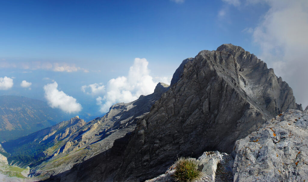
This Is Where the Mountain Changes Character.
From Skala, the line to Mytikas leaves ordinary hiking behind. The marked Kakoskala route crosses steep, exposed rock before reaching the highest point in Greece.
Photo: Stolbovsky / Wikimedia Commons · CC BY-SA 3.0
Mytikas, Skolio or Louki?
Olympus gives you more than one good objective. The right choice depends on exposure tolerance, conditions and experience rather than summit prestige alone.
| Route | From Refuge A | Gain | Time | Published Rating | Best Use |
|---|---|---|---|---|---|
| Skala → Mytikas via Kakoskala | 3 km | +818 m | 3 h | Medium Difficult | Classic first Mytikas route for hikers already comfortable with exposed scrambling. |
| Skala → Skolio | 3.1 km | +816 m | 3 h | Medium | Best lower-exposure alternative |
| Zonaria → Louki → Mytikas | 3.2 km | +865 m | 3.5 h | Very Difficult | More experienced parties; Refuge A explicitly says helmets are required. |
The Standard Mytikas Decision
Reach Skala first. If the rock is dry, visibility is good, wind is manageable and exposed scrambling feels normal rather than intimidating, continue toward Mytikas. If not, turn toward Skolio or descend.
The Strong Alternative
Skolio reaches the high Olympus skyline without the same exposed summit finish. It is not a consolation prize; for many hikers it is the smarter objective on a marginal-weather day or a first visit.
The Crux Is Exposure, Loose Rock and a Long Day
At 2,918 m, Olympus is not primarily an extreme-altitude problem. The upper rock, weather, route timing and total vertical effort matter more.
A Slip Can Matter
The Kakoskala finish crosses steep rocky ground with significant exposure. This is the central reason a confident trail hiker may still decide not to summit Mytikas.
Other Hikers Change the Hazard
Broken limestone and people above can create rockfall. Keep spacing, avoid knocking stones onto lower parties and consider a helmet on the summit terrain.
Fog and Wind Change the Route Fast
Cloud can make markings harder to follow, while strong wind or wet rock increases consequence on exposed steps. The summit section should feel conservative in the conditions you actually have.
1,830 Metres Before the Descent
The published Prionia-to-Mytikas line gains 1,830 m. A hiker who arrives at Skala depleted has already received useful information about whether to continue.
Busy Rock Takes Patience
Passing and descending parties can slow the narrow upper route. Build enough time into the plan that crowds do not create pressure to rush exposed terrain.
You Have to Reverse the Terrain
Comfort climbing upward does not automatically mean comfort descending the same rocky steps. If down-climbing exposure is unfamiliar, a guide or a Skolio objective may be the better plan.

The Upper Mountain Is Open, Rocky and Weather-Exposed.
Summer can look benign from Litochoro while wind, cloud and colder air are already affecting the summit ridge. Treat the upper-mountain forecast as its own decision.
Photo: kallerna / Wikimedia Commons · CC BY-SA 4.0
The Refuge Makes the Classic Two-Day Plan Work
As of September 3, 2026, the refuge website reports Refuge A fully open and publishes live bed availability.
What to Expect
- Elevation: about 2,100 m
- Capacity: up to 103 guests
- Normal season: beginning of May through end of October
- Meals available daily during operation
- Reservations strongly recommended in peak periods
- Boots stay out of the sleeping/dining interior areas
More Margin on Summit Day
- Splits the 1,830 m ascent across two days.
- Lets you start the upper mountain with fresher legs.
- Creates a natural point to ask about current weather and route conditions.
- Reduces pressure to force Mytikas because the approach took longer than expected.
- Gives Skolio more value as a same-day alternative.
When Is the Best Time to Hike Mount Olympus?
Visit Greece describes June through October as the most accessible climbing period. For a first Mytikas attempt, the cleaner summer window is usually narrower.
| Period | Typical Character | Best For | Main Caution |
|---|---|---|---|
| May–June | Spring / early season | Lower trails, quieter refuge trips | Snow or ice may remain high and change the Mytikas problem. |
| July–September | Main summer window | Most first-time Mytikas hikers | Heat lower down, afternoon storms, wind and summit traffic. |
| October | Autumn shoulder season | Experienced hikers using stable forecasts | Shorter daylight and faster return of winter conditions. |
| Winter | Snow / ice mountaineering | Experienced winter teams | The mountain is no longer the same hiking objective described on this page. |
Conditions Matter More Than the Calendar
The route grade is a planning baseline. The decision at Skala should be made from the actual rock, cloud, wind and forecast in front of you.
Good Signals
- Dry rock
- Clear or stable visibility
- Manageable wind
- No thunderstorm threat during the exposed section
- Enough energy for the full descent
- Comfortable down-climbing exposed rock
Bad Signals
- Wet or icy rock
- Fog obscuring markings
- Strong gusts
- Thunderstorms building
- Late timing
- Fatigue, hesitation or loss of concentration at Skala
What to Carry for the Classic Mytikas Route
The equipment list is not expedition-heavy. The important details are grip, weather protection, head protection and enough reserve for a very long descent.
| Gear | Why It Matters | Mytikas Note |
|---|---|---|
| Grippy hiking or approach footwear | Loose gravel, limestone and long descent | More important once the route becomes exposed rock. |
| Helmet | Loose rock and parties above | Prudent on Mytikas; explicitly required by Refuge A on Louki. |
| Windproof / waterproof shell | Rapid upper-mountain weather change | Exposure magnifies wind and cold. |
| Warm layer + light gloves | Large temperature change from Prionia to summit | Useful even on warm days below. |
| Headlamp | Predawn start or delayed descent | Carry one even on a planned daylight itinerary. |
| Food + water | Large vertical day | Do not plan on finding water on the exposed summit section. |
| Offline map / GPX | Fog or navigation uncertainty | Official Refuge A GPX tracks are available to download. |
Do You Need a Guide for Mytikas?
The useful question is whether your party already has the movement and judgment needed for exposed scrambling—not whether you can physically hike to Skala.
You Already Know This Terrain
- Exposed scrambling does not change your pace or decision-making.
- You are comfortable descending the same rocky ground you climb.
- You can navigate if cloud removes obvious visual cues.
- You will turn around without debate if conditions deteriorate.
The Summit Section Is New to You
- Mytikas would be your first exposed mountain scramble.
- You want rope protection or coaching where appropriate.
- You are unsure how to read wet rock, wind or cloud on the upper route.
- You want local route knowledge rather than learning the line while exposed.
Two Days Is the Better First-Time Plan
The one-day ascent is possible for strong hikers. The refuge plan is better at separating endurance from the exposed summit decision.
Start at about 1,100 m after checking the latest upper-mountain forecast.
Climb roughly 1,000 m through forest, eat, rest and ask about conditions.
Reach the decision point with fresh legs. Mytikas is optional from here.
Choose the summit that fits the weather, terrain and your actual comfort.
Litochoro → Prionia
Litochoro is the standard gateway town. Prionia is the classic road-access starting point for the Refuge A / Mytikas itinerary.
Base Before the Mountain
Use Litochoro for lodging, food and last-minute supplies. Visit Greece also uses Litochoro as the natural starting gateway for Olympus and the Enipeas Gorge.
Highest Road-Access Start
Refuge A describes Prionia as the highest point on Olympus accessible by car, about 18 km from Litochoro, with parking, toilets, spring water and a café/restaurant.
Official Olympus Route Information
Prionia → Mytikas Route
Publishes the 11.5 km, +1,830 m, 7-hour uphill route and the Very Difficult rating for the complete ascent.
Open route →Upper Route Directory
Publishes the Mytikas-via-Skala, Skolio and Louki alternatives with distances, elevation gain, time and route ratings.
Compare routes →Visit Greece
Confirms Prionia at 1,100 m, Spilios Agapitos around 2,100 m, Mytikas at 2,918 m and the challenging Skala-to-Mytikas finish.
Open Visit Greece →Official Trail Map
The national-park map identifies Prionia–Spilios Agapitos, Refuge A–Skala–Mytikas and Louki as distinct marked route systems.
Open official map →European Peaks & Mountain Skills
Best Mountains in Europe
Compare Olympus with hiking peaks, alpine classics and higher technical objectives across Europe.
Explore Europe →Scrambling comparisonMount Triglav
Compare another national high point where straightforward hiking transitions into exposed upper-mountain movement.
Compare Triglav →MediterraneanMount Etna
A very different Mediterranean mountain problem shaped by volcanic access and current eruption restrictions.
Open Etna →High summit hikingMount Teide
Compare higher elevation with simpler summit terrain and a permit / cable-car planning system.
Open Teide →WeatherMountain Weather for Climbers
Read wind, cloud, freezing level and storm timing before entering exposed upper-mountain terrain.
Read weather →Guide decisionGuided vs Independent Climbing
Use this when the Mytikas scramble is a new movement problem rather than just another long hike.
Compare approaches →NavigationNavigation & Emergency Communication
Build a backup plan for cloud, route uncertainty and limited communication in mountain terrain.
Review navigation →Country high pointsHighest Mountain in Every Country
Place Mytikas in the broader world of national high points without turning this hiking page into a global list.
Compare high points →Mount Olympus Greece FAQ
How hard is it to hike Mount Olympus to Mytikas?
The approach to Skala is a strenuous mountain hike; the final section from Skala to Mytikas is exposed scrambling. Refuge A rates the complete Prionia–Refuge A–Skala–Mytikas ascent Very Difficult, with 11.5 km, 1,830 m of gain and about 7 hours uphill.
How high is Mytikas?
Mytikas is the highest summit of Mount Olympus and the highest point in Greece at 2,918 metres in current Visit Greece and Refuge A material.
How long does it take to hike from Prionia to Mytikas?
Refuge A publishes about 7 hours uphill for the complete 11.5 km route with 1,830 metres of ascent. That does not include the full return to Prionia.
Is Skolio easier than Mytikas?
Yes. Refuge A rates the route to Skolio Medium, while Mytikas requires the more exposed Kakoskala finish. Skolio is a strong alternative when conditions or comfort make Mytikas a poor choice.
Is Refuge A open in September 2026?
Yes as of September 3, 2026. The Spilios Agapitos Refuge website currently reports the refuge fully open and shows live availability. Its normal operating season runs from the beginning of May through the end of October.
Do I need a helmet for Mytikas?
A helmet is prudent on the exposed rocky summit terrain because of loose rock and climbers above. Refuge A explicitly requires helmets on the more serious Louki route.
Can I climb Mount Olympus in one day?
Strong and experienced hikers can complete the Prionia–Mytikas line in one long day, but Refuge A’s published time is about 7 hours uphill before the full descent. Two days gives more margin for weather and fatigue.
When is the best time to hike Mount Olympus?
Visit Greece describes June through October as the most accessible climbing period. July through September is generally the cleanest first-time summer window, although upper-mountain weather still changes quickly.
Where should I stay on a two-day Olympus hike?
Spilios Agapitos Refuge A is the standard overnight stop on the Prionia approach. It sits at about 2,100 metres and currently accommodates up to 103 guests.
What is the best alternative if I do not want the Mytikas scramble?
Skolio. From Refuge A, the official route is 3.1 km, gains 816 metres and is rated Medium. It gives you a high Olympus summit without the same exposed Kakoskala finish.
Hike to Skala. Decide on Mytikas There.
For a first visit, the strongest Mount Olympus plan is two days: Prionia to Refuge A, then an early climb to Skala. If the rock is dry, visibility is good and exposed scrambling is already within your comfort zone, continue to Mytikas. If not, turn toward Skolio or descend. The trip remains a complete Mount Olympus experience without forcing the mountain’s most exposed hiking route.
Mount Olympus: Home of the Gods
No mountain has shaped the Western imagination more. For the ancient Greeks, cloud-wrapped Olympus was the very home of the gods – and though the gods have gone quiet, the mountain still carries three thousand years of myth on its summit.
The Palace Above the Clouds
In Greek mythology, Olympus is the home of the twelve Olympian gods, its highest, cloud-hidden peak the palace of Zeus – a divine realm set deliberately beyond the reach and sight of mortals.
The Earthly Gateway
At the mountain’s foot lay Dion, the sacred city where the Macedonians offered sacrifice to Olympian Zeus – the human threshold to a mountain thought too holy to climb.
Protected as It Was Revered
Untrodden to its summit until 1913, Olympus became Greece’s first national park in 1938 and a UNESCO Biosphere Reserve – guarded now for its nature as it once was for its gods.
The Peaks That Crown the Myth
Its highest summit, Mytikas at 2,918 m, and the great rock buttress of Stefani – the ‘Throne of Zeus’ – give a real and dramatic shape to the mountain that gave the West its gods.
Olympus Among the Sacred Peaks of the World
The home of the Greek gods is one of the world’s great sacred mountains. Explore the collection and the other holy summits below.
Was this helpful?
🏔Related peaks nearby
🧭Explore & compare
Global Summit Guide is an independent mountaineering resource founded in 2026. The team combines first-hand trekking and climbing experience with in-depth research and professional health and nutrition review to help climbers choose objectives, prepare properly, and stay safe.
Health, altitude, and nutrition content is reviewed by Taylor Ludlow (Registered Nurse) and Brigg Hoopes (Nutritionist).
What We Don't Know Yet
Mountain information changes quickly. This box explains the limits of what this page can responsibly promise.
- Route conditions, trailhead access, crevasse exposure, stream crossings, and rescue access may vary from published planning guidance.
- Visa, passport, vaccination, border, insurance, and local transportation rules may change before your trip.
- Route conditions, snowpack, closures, and weather can change quickly after this page is updated.
- Permit rules, fees, quotas, and reservation windows may change between review cycles.
- Operator availability, pricing, guide ratios, and cancellation terms can change by season.
Verify current conditions with official land managers, guide services, local forecasts, and current route reports before booking or climbing.
Mountaineering, rock and ice climbing, glacier travel, and high-altitude activity are inherently dangerous and can result in serious injury or death. The information on Global Summit Guide is provided for general informational and educational purposes only and is not a substitute for professional instruction, qualified guiding, proper equipment, or your own judgment and experience.
Route conditions, weather, snowpack, permits, regulations, and hazards change constantly and may differ from what is described here. Details may be incomplete, out of date, or contain errors. Always verify current information with local authorities, certified guides, and official sources before making any decision in the mountains.
Nothing on this site is medical, legal, or financial advice. Our fitness, acclimatization, altitude, and nutrition content is general in nature; consult a qualified physician before beginning any strenuous exercise program or exposing yourself to high altitude.
You are solely responsible for your own safety and decisions. To the fullest extent permitted by law, Global Summit Guide and its team accept no liability for any loss, injury, damage, or expense arising from use of, or reliance on, this information. By using this site you acknowledge these risks and accept these terms.
Some links on this site may be affiliate links. If you buy through them we may earn a small commission at no extra cost to you; this never affects our recommendations.
Global Summit Guide recommendation path
Next Best Mountain to Research
Use these recommendations to continue the right planning path instead of stopping on one page.
Use current permit, weather, route, and operator information before booking or climbing.
Explore Travel Options for Your Destination
Once your mountain, dates and route are taking shape, compare flights, hotels and other travel options that fit the trip.
Affiliate link. We may earn a commission at no additional cost to you.