
Last updated September 20, 2026
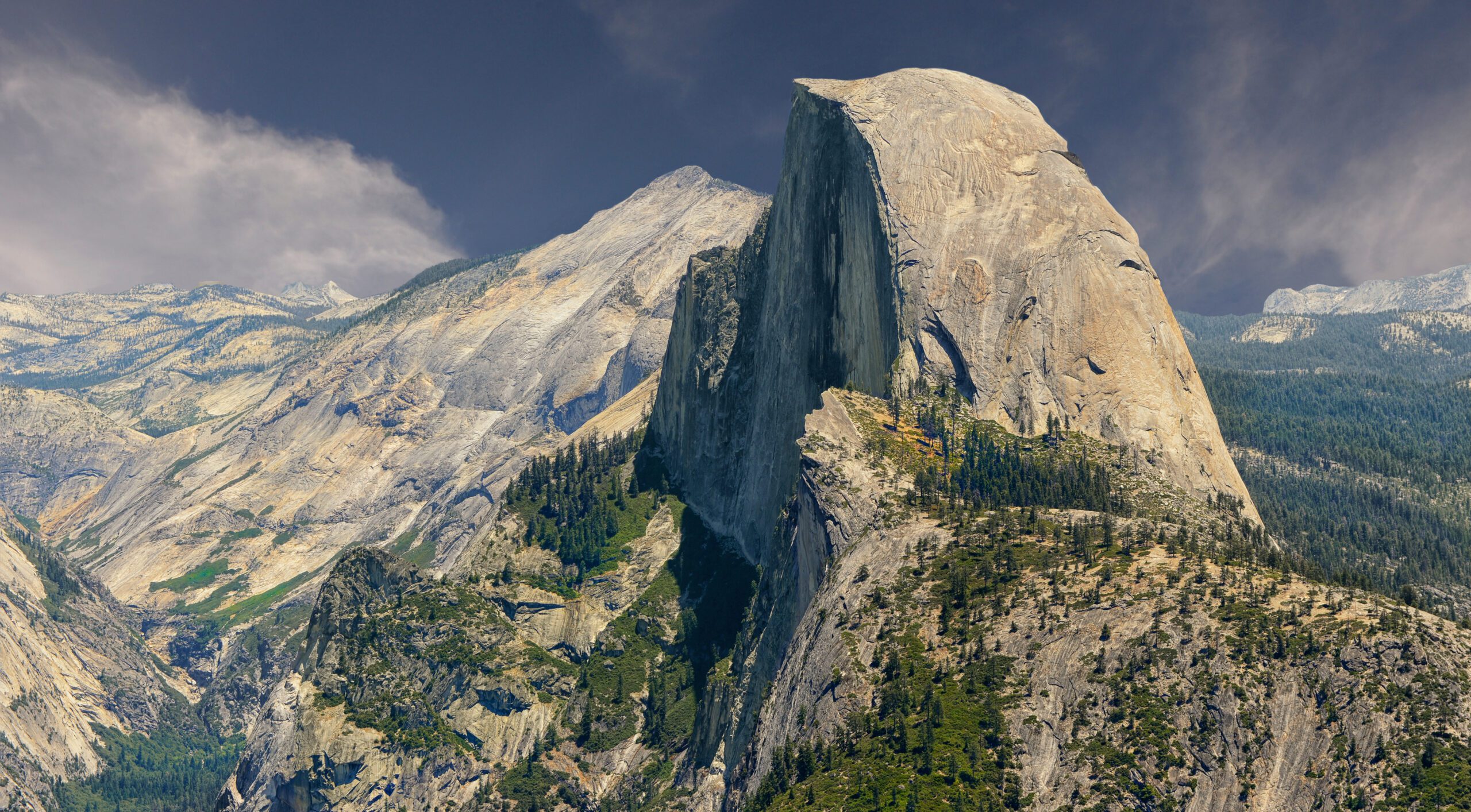
Half Dome Hike Guide: Permits, Cables, Difficulty & Route
Half Dome is a 14–17 mile, roughly 4,800-foot-gain Yosemite day hike that usually takes 10–14 hours. The standard hiking route is nontechnical while the cables are installed, but the final 400 vertical feet are steep, exposed and permit-controlled. For most hikers, the real decisions are permit timing, route choice, readiness, weather and whether to turn around before the cables.
Is Half Dome Worth Hiking?
Yes—if you want one of America’s most iconic strenuous day hikes and are comfortable with exposure. The standard route combines Vernal Fall, Nevada Fall, Little Yosemite Valley, Subdome and the famous cable ascent into one long day.
The cables make the final section accessible to strong hikers without technical rock-climbing skills, but they do not make Half Dome easy. The hike is long, the elevation gain is substantial, and wet granite or thunderstorms can turn the cable section into a poor decision very quickly.
Half Dome Permits: What You Need to Know
Permits are required seven days per week when the cables are up.
| Permit path | When | Who it fits | Key rule |
|---|---|---|---|
| Preseason lottery | March 1–31 | Best for planned trips | 225 day-hiker permits available per date |
| Daily lottery | 2 days before hike | Flexible / last-minute hikers | Availability depends on cancellations and under-use |
| Backpacker permit | With wilderness permit process | Overnight itineraries | Separate process from day-hiker lottery |
Which Route Should You Take to Half Dome?
| Route strategy | Best use | Advantages | Tradeoff |
|---|---|---|---|
| Mist Trail up / JMT down | Best overall choice | Most scenic ascent; gentler descent | Wet / steep Mist Trail stairs |
| JMT both directions | More gradual approach | Less steep than Mist Trail | Longer mileage |
| Mist Trail both directions | Shortest lower route | Direct | Harder on knees; slippery when wet |
What Are the Half Dome Cables Actually Like?
The cables are the psychological and safety crux of the standard route.
Steep Granite
The final section climbs the steep east face using two steel cables raised on posts. Falling consequences are serious.
Two-Way Movement
Ascending and descending hikers use the same cable system. Crowding can slow progress and increase stress.
Dry Granite Only
Rain dramatically reduces traction. Thunderstorms add lightning exposure on an open granite summit.
Controlled, Not Rushed
Maintain space, use deliberate foot placements and do not allow faster hikers behind you to dictate unsafe pacing.
Are You Ready for Half Dome?
Fitness is necessary, but exposure and decision-making matter too.
| Readiness test | Good benchmark | If not |
|---|---|---|
| Long hike | 12–15 miles in one day | Build endurance first |
| Vertical gain | 3,000–4,000 ft comfortably | Add sustained climbing workouts |
| Time on feet | 8+ hours without major breakdown | Increase long-day durability |
| Downhill tolerance | Controlled descent after fatigue | Train quads / knees |
| Exposure | Can function calmly near steep drop-offs | Choose lower-exposure objectives first |
| Turnaround discipline | Willing to skip summit in bad weather | Do not attempt yet |
When Should You Hike Half Dome?
Waterfalls Peak
Vernal and Nevada Falls can be spectacular, but wet trail surfaces and lingering snow can complicate the day.
Longest Days
Most predictable cable access, but also heat, crowds and afternoon thunderstorm risk.
Best Balance
Cooler temperatures and generally lower weekday demand make September a strong target, though early storms remain possible.
Closing Window
Cooler hiking but shorter days and increasing chance of early winter weather before cables come down.
What Should You Bring?
| Item | Why |
|---|---|
| Reliable hiking footwear | Long mileage plus granite stairs and cable traction |
| Work gloves | Grip and hand protection on the cables |
| Headlamp | Pre-dawn start / delayed return |
| 3–4L water capacity + treatment | Long exposed day |
| Food / electrolytes | 10–14 hour effort |
| Rain shell + insulation | Sierra weather changes rapidly |
| Sun protection | Long exposed granite sections |
| Permit + ID | Ranger check near Subdome |
When Should You Turn Around?
Thunderstorms Building
Do not wait until lightning is overhead. Half Dome’s exposed granite is not where you want to discover the forecast was wrong.
Cables Are Wet
Wet granite materially changes the cable section. A permit is not an obligation to climb.
Behind Schedule
Protect daylight and reserve energy for the long descent back to Yosemite Valley.
Already Depleted at Subdome
The summit is not halfway psychologically, but the descent still contains thousands of feet of work.
What About Technical Climbing Routes on Half Dome?
The standard Half Dome hike and technical Half Dome climbing are separate objectives. Snake Dike and the Regular Northwest Face require climbing-specific skills, protection systems and route planning. This page owns the hiking/cables intent; technical climbers should use route-specific climbing resources rather than applying hiking advice to technical terrain.
Current official facts checked
- Half Dome permit requirement while cables are up
- 300-person daily cap beyond Subdome
- March preseason lottery
- Daily lottery two days before
- Typical cable season timing
- 2026 Yosemite entrance reservation status
What must be rechecked before hiking
- Exact cable installation/removal dates
- Trail closures
- Wildfire / smoke conditions
- Thunderstorm forecast
- Water availability
- Permit confirmation and ID
Half Dome FAQ
How hard is the Half Dome hike?
Half Dome is an extremely strenuous day hike: roughly 14–17 miles round trip, about 4,800 feet of gain and often 10–14 hours.
Do you need a permit to hike Half Dome?
Yes. A permit is required seven days per week when the cables are up.
When are the Half Dome cables up?
Normally from the Friday before Memorial Day until the day after the second Monday in October, subject to conditions.
Can a beginner hike Half Dome?
A strong hiker can complete the standard route without technical climbing skills, but Half Dome should not be a first major hike.
What is the best route?
Mist Trail up and John Muir Trail down is a strong balance of scenery, efficiency and a gentler descent.
How many Half Dome permits are available?
NPS allows up to 300 hikers per day beyond Subdome, including about 225 day hikers and 75 backpackers.
Is Half Dome dangerous in rain?
Yes. Wet granite dramatically reduces traction on the cables. Do not attempt the cables in rain or thunderstorms.
How early should I start?
Many hikers start before sunrise to protect daylight and reduce exposure to afternoon heat, crowds and storms.
Win the Permit. Train for the Day. Earn the Summit Only If Conditions Cooperate.
Half Dome is memorable because the route demands more than mileage. Good planning means reaching the cables with enough fitness, daylight and judgment to decide whether continuing is still the right call.
More Mountains in California
Other major peaks nearby, each with a full guide to routes, permits and difficulty.
The Cables Are Up—and the Weekday Mist Trail Detour Matters.
Yosemite’s September 18, 2026 conditions update says the Half Dome cables are up for the season, so a permit is required beyond Subdome. Yosemite does not require an entrance reservation in 2026; the Half Dome permit remains a separate requirement.
Through October, the Mist Trail between the John Muir Trail junction above Vernal Fall Footbridge and the top of Vernal Fall is normally closed for repair work Monday–Thursday from 7:00 a.m. to 3:30 p.m., subject to change. The John Muir Trail is the alternate during that closure window.
How the Half Dome Lottery Actually Works
The details below are the pieces most likely to affect whether your permit is valid—and whether your application is competitive.
| Permit path | When | Current rule | Best strategy |
|---|---|---|---|
| Preseason lottery | March 1–31 | 225 day-hiker permits per date; up to 6 people per application | Use date flexibility and prioritize weekdays when possible. |
| Permit holder + alternate | Set during preseason application | One must be present; names cannot be changed later | Add an alternate during the original application if there is any chance the primary applicant cannot hike. |
| Daily lottery | Two days before; midnight–4 p.m. Pacific | Supply comes from estimated cancellations / under-use; no alternate | NPS says weekdays, especially from late August, generally have better odds. |
| Backpacker permit | Wilderness-permit process | About 75 people/day are included in the 300-person Half Dome cap | Use this route if Half Dome is part of an overnight wilderness trip. |
| Application fee | When applying | $10 per application; non-refundable | Use realistic dates and group size. |
| Awarded permit fee | When awarded | $10 per person | NPS allows this fee to be refunded with timely cancellation under its stated rules. |
Permit odds reward flexibility more than tricks.
The permit holder or accepted alternate must be with the group at Subdome. There is no legitimate transfer workaround.
Half Dome Timing: Cables, Weather, Water and the Descent
Start with daylight, weather and return margin—not only a target summit time.
Protect Daylight
A pre-dawn start creates margin for cable traffic, trail detours and a slower-than-expected descent.
Check the Detour
Current weekday repair closures can push hikers onto the John Muir Trail during daytime work hours.
Carry a Real Hydration Plan
NPS has advised roughly one gallon / 4 liters per person for Half Dome in hot conditions, adjusted for weather and safe refill opportunities.
Reassess Before the Cables
Fatigue, wet granite, building cloud or a late arrival are all valid reasons to turn around.
Do Not Wait Out Lightning
An exposed granite summit is the wrong place to discover that a storm is moving faster than expected.
Save Energy for Thousands of Feet Down
Protect knees, daylight, food and water for the return to Yosemite Valley.
September 2026: Yosemite’s wilderness update says freezing nights are becoming common at higher elevations and some water sources are scarce. Fall can be excellent, but it still requires a live forecast and water plan.
Mist Trail Up / JMT Down Is Still the Best Default—When the Mist Trail Is Open
The mixed loop remains a strong balance of scenery and descent comfort, but 2026 repair work can alter the lower route.
| Choice | Why use it | Tradeoff | 2026 note |
|---|---|---|---|
| Mist up / JMT down | Scenic ascent; gentler descent | Steep, wet stairs | Best when Mist Trail is open at your passage time. |
| JMT both ways | More gradual lower approach | Longer distance | Practical weekday detour when repair closure is active. |
| Mist both ways | Most direct lower route | Hard descent; slippery granite | May not be available during weekday work hours. |
| Little Yosemite Valley overnight | Splits the physical effort | Wilderness-permit logistics | Request Half Dome access with the wilderness permit. |
Yosemite Valley → Vernal Fall → Little Yosemite Valley → Half Dome
Orientation only—not a substitute for an offline trail map.
Where to Go After Half Dome
Compare another Sierra objective, strengthen weather planning, or move into a broader nontechnical-peak progression.
Half Dome 2026 FAQ
Current details that complement the main page FAQ.
Are the Half Dome cables up right now?
Yes. Yosemite’s September 18, 2026 conditions update says the cables are up for the season.
Does Yosemite require an entrance reservation in 2026?
No. An entrance reservation is not required in 2026, but a Half Dome permit is still required when the cables are up.
How much does the Half Dome lottery cost?
The application fee is $10 per application. If awarded, the permit fee is another $10 per person.
Can I transfer my permit?
No. The permit holder or accepted alternate must be present; names cannot be changed after submission.
Is the Mist Trail open on weekdays in September 2026?
Partially. Through October, the section above Vernal Fall Footbridge is normally closed Monday–Thursday from 7:00 a.m. to 3:30 p.m., subject to change, with the John Muir Trail as the alternate.
What days usually have better daily-lottery odds?
NPS says chances are generally better on weekdays, especially beginning near the end of August. Historical statistics do not guarantee a future result.
Was this helpful?
🏔Related peaks nearby
🧭Explore & compare
Global Summit Guide is an independent mountaineering resource founded in 2026. The team combines first-hand trekking and climbing experience with in-depth research and professional health and nutrition review to help climbers choose objectives, prepare properly, and stay safe.
Health, altitude, and nutrition content is reviewed by Taylor Ludlow (Registered Nurse) and Brigg Hoopes (Nutritionist).
What We Don't Know Yet
Mountain information changes quickly. This box explains the limits of what this page can responsibly promise.
- Permit availability, reservation windows, quotas, and official fee rules may change after this page is updated.
- Route conditions, trailhead access, crevasse exposure, stream crossings, and rescue access may vary from published planning guidance.
- Visa, passport, vaccination, border, insurance, and local transportation rules may change before your trip.
Verify current conditions with official land managers, guide services, local forecasts, and current route reports before booking or climbing.
Mountaineering, rock and ice climbing, glacier travel, and high-altitude activity are inherently dangerous and can result in serious injury or death. The information on Global Summit Guide is provided for general informational and educational purposes only and is not a substitute for professional instruction, qualified guiding, proper equipment, or your own judgment and experience.
Route conditions, weather, snowpack, permits, regulations, and hazards change constantly and may differ from what is described here. Details may be incomplete, out of date, or contain errors. Always verify current information with local authorities, certified guides, and official sources before making any decision in the mountains.
Nothing on this site is medical, legal, or financial advice. Our fitness, acclimatization, altitude, and nutrition content is general in nature; consult a qualified physician before beginning any strenuous exercise program or exposing yourself to high altitude.
You are solely responsible for your own safety and decisions. To the fullest extent permitted by law, Global Summit Guide and its team accept no liability for any loss, injury, damage, or expense arising from use of, or reliance on, this information. By using this site you acknowledge these risks and accept these terms.
Some links on this site may be affiliate links. If you buy through them we may earn a small commission at no extra cost to you; this never affects our recommendations.
Global Summit Guide recommendation path
Next Best Mountain to Research
Use these recommendations to continue the right planning path instead of stopping on one page.
Use current permit, weather, route, and operator information before booking or climbing.
Search Flights, Hotels & Rental Cars
Have the mountain or destination picked? Use Expedia to compare the flights, lodging and rental cars that fit your actual trip dates. For mountain travel, consider arriving early enough for delays and adding a buffer night after the climb before a fixed flight home.
Compare current flight, hotel and car options.
Affiliate disclosure: Global Summit Guide may earn a commission if you book through this link, at no additional cost to you.